
A slow moving front extending from the Great Lakes region into the Plains will bring snow, wintry mix, and ice accumulation north of the front from the Upper Midwest into New England, and severe weather and heavy rain south of the front. Scattered severe thunderstorms with damaging gusts, severe hail, and heavy rain are expected across parts of the Great Lakes/Midwest through tonight. Read More >
March 23, 2007 Lea County Severe Weather
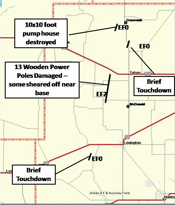
On Saturday, March 24, 2007, the National Weather Service in Midland conducted a damage survey of storms that affected Lea County, New Mexico. The following provides the results of that survey.
Around 12:30 pm MDT on Friday, March 23, thunderstorms began to develop over the Guadalupe Mountains of Eddy County. Thunderstorms continued to rapidly develop, becoming severe over portions of Eddy County 1:45 pm MDT. Thunderstorms also were developing over eastern portions of Culberson County during this time and these thunderstorms would eventually affect Lea County later in the afternoon.
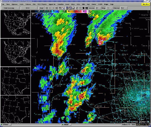
At 3:39 pm MDT, a thunderstorm located in western portions of Lea County just northwest of the community of Halfway began to exhibit supercellular characteristics. This prompted the National Weather Service in Midland
to issue a Severe Thunderstorm Warning at 3:42 pm MDT for western portions of Lea County. As the supercell thunderstorm moved northeast at 30 mph, the storm continued to intensify. The presence on radar of an intensifying mesocyclone (storm rotation) and a bounded weak echo region, along with key spotter information relayed into our office through amateur radio Net Control Operations prompted an upgrade to a tornado warning. Spotters indicated a developing wall cloud over the area had become “fully formed” with increasing surface wind inflow. The National Weather Service in Midland issued a tornado warning for northern portions of Lea County at 4:28 pm MDT.
At 4:32 pm MDT, Jim Morrison, Area Skywarn Coordinator for Lea County, reported a tornado touchdown with a small debris cloud approximately 12 miles west southwest of the city of Lovington. At 4:36 pm MDT, trained spotters
also viewed the same tornado from State Highway 457 looking southward. Damage survey interviews with officials and residents revealed that the brief tornado remained over pasture lands. An EF0 rating was assigned to this first tornado west southwest of Lovington.
At 4:50 PM MDT, spotters indicated the presence of two wall clouds. Primary indications are that the new wall cloud spawned a second tornado with the supercell thunderstorm 7 ½ miles west of the community of McDonald, just
south of County Road 147. Survey of damage along County Road 147 led to an estimation of tornado width at 50 yards at this point
Tornadic thunderstorm while southwest of Tatum.
The tornado continued to intensify as it moved northeast. Significant damage was seen 7 ½ southwest of the community of Tatum over ranchland. At this location, 13 wooden power poles were damaged, three snapped off at
ground level and others snapped 3-12 feet above ground. A water trough weighing an estimated 300 pounds was thrown from the tornado for several hundred feet. Utilizing tornado wind speed estimation techniques from the
Enhanced Fujita Scale, wind speed estimates have been placed at approximately 118 mph based on visible damage and an EF2 rating has been assigned for this second tornado. The tornado was visually estimated at this location to be ½ mile in width and was described as “clean” in appearance.
Redeveloping circulation seen 6 miles southwest of Crossroads.
Damage along this track supports this estimate. It is believe that tornado lifted just south of State Highway 380, 6 ½ miles west of Tatum. This would place the damage path length at approximately 9 miles. Spotters also
confirmed that the tornado exhibited multiple vortex structure at times during its life cycle. The National Weather Service in Midland extended the tornado warning until 6:30 pm MDT based on both radar and spotter information.
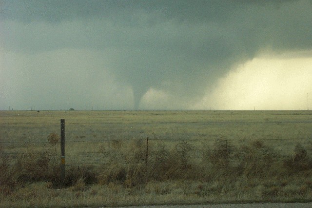
Image provided by Jim Morrison.
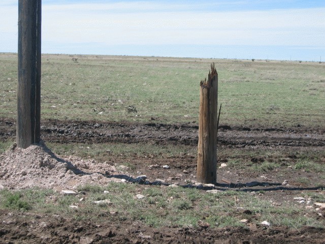
Sheared power poles 7 miles southwest of Tatum
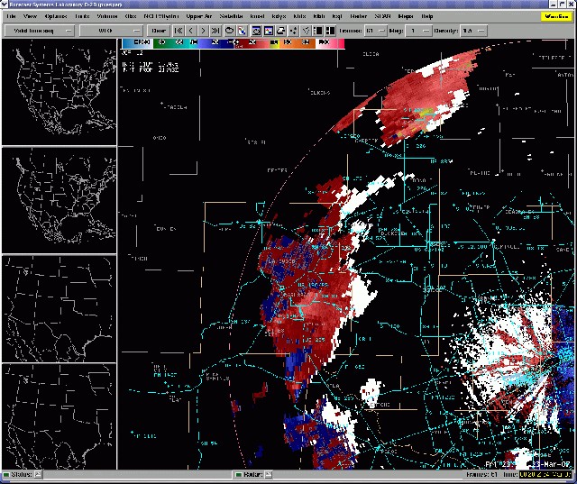
The supercell thunderstorm, continued to display cyclical characteristics. At 5:34 pm MDT, Storm Relative Velocity data showed the presence of a weakening mesocyclone (storm rotation) and the redevelopment of a new stronger mesocyclone (circulation) just west of State Highway 206, 5 miles south of the community of Crossroads. At 5:36 pm MDT, spotters had visual indications of a rope tornado 6 miles south of Crossroads. This remained over range land just west of State Highway 206. An EF0 rating has been assigned for this third tornado.
A fourth tornado was also witnessed 3 miles southwest of the community of Crossroads where is destroyed a 10 x 10 foot oil field pump house. This tornado also remained over open country and is being assigned an EF0 rating.
As an interesting note, hail between pea size up to nearly quarter size was seen on the ground, 16 hours after the event’s conclusion. Residents 3 miles west of Crossroads also noted that hail accumulated to approximately
6 inches in depth with the storm. The largest hail that fell near Crossroads was estimated at baseball size based on ground indentations. However, the majority of the accumulated hail was believed to have been between
quarter and golf ball size.
The final map of the damage tracks for the Lea County tornadoes are indicated in the image below.
If you have additional questions about the Lea County damage survey, please contact the National Weather Service in Midland at 432-563-5006.

