
More than 200 record or near record maximum temperatures are forecast across the southern half of the U.S. through the end of this week before additional record temperatures center back over the Southwest U.S. into the Rockies this weekend. Widespread record breaking warmth, low humidity, and gusty winds will produce critical fire weather today in the central Rockies to Plains. Read More >
January 23, 2007 Heavy Snow
Recent winter weather has left some questions unanswered.
An event that appeared to be more of a nuisance type snow event for portions of southeast New Mexico and the mountains of southwest Texas became a much more significant winter storm. The following are total snowfall accumulations that have been reported to the National Weather Service in Midland.
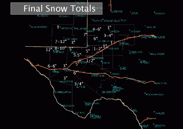
An upper level storm system unexpectedly became nearly stationary over the western portions of the Texas Permian Basin early this morning. This allowed for much of southeast New Mexico, the Guadalupe Mountains, and the western and northwest portions of the Texas Permian Basin to received much more snow than originally anticipated.
The close proximity of the upper level storm system, which stalled over Winkler County, allowed temperatures to cool sufficiently above the ground to produce snow. Favorable positioning of the jet stream in the upper levels of the atmosphere provided more enhancement to the lifting air. The end result of these subtle changes was a major increase in expected snowfall.
This cooling of the air above the ground was similar to what had been expected last week. By the middle of last week, computer forecast models were indicating the potential for a winter weather snow event over West Texas. Computer models showed sufficiently cold air to moisture for as much as 10-12 inches of snow from Midland to Andrews and into southeast New Mexico.
Winter Storm Watches were issued by the forecasters at WFO Midland on Wednesday. As more information became available on Thursday, Winter Storm Watches were upgraded to Winter Storm Warnings for much of the area.
A Winter Storm Warning implies that hazardous winter weather, weather that is a threat to life and property, is imminent or will occur. That winter weather can come in the form of a quarter inch or greater of sleet or ice from freezing rain, 4 inches or more of snow in 12 hours, or 6 inches of snow or more in a 24 hour period. Based on overwhelming computer model indications and office experience, it was thought that snow would be predominent. In reality, a shallow layer of air 2-3 degrees above freezing between 2000 and 8000 above the ground resulted in a totally different outcome.
While Winter Storm Warnings were still warranted, the subtle increase in temperature, not seen in the forecast models, resulted in a mix of rain, freezing rain, and very little sleet. Hazardous conditions did exist, but not in the form expected.
Winter weather is challenging. A small change in storm position and temperature can result in big changes in the end result. The National Weather Service in Midland will continue to investigate these types of events to make advances in future events as we continue to meet our mission to protect the lives and property of those living in southeast New Mexico and west Texas.

