
Dangerous heat will expand from the Gulf Coast into the Southern Plains and Desert Southwest through week's end. Additional extreme heat impacting the Pacific Northwest will shift to the northern Plains by the weekend. Tropical Storm Bertha is expected to continue to impact portions of the northwestern Gulf Coast from south central Louisiana to the upper Texas coast today. Read More >
SE NM and Permian Basin Wildfires January 1
A strong low pressure system deepened across northern Oklahoma and southern Kansas on New Year's Day. Strong winds and low relative humidity values swept into West Texas and Southeastern New Mexico behind this system. These conditions created favorable conditons for rapid and explosive fire growth and spread. Several wildfires broke out across the region, and the most damaging fires affected Lea county in southeast New Mexico.
The following graphics illustrate the weather conditions which affected the region during the middle afternoon hours of January 1, 2006.
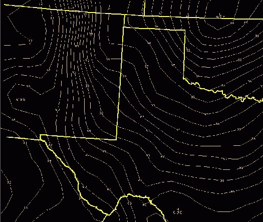
This first graphic is an analysis of the surface pressure pattern across the region around 3 pm CST Sunday afternoon. Surface low pressure was deepening across northern Oklahoma and southern Kansas. A tight surface pressure gradient extended into West Texas and Southeastern New Mexico, which resulted in the very strong wind speeds.
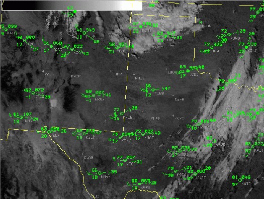
This is a visible satellite image with surface observations overlaid. The time of this image was around 3 pm CST (2 pm MST). If you look closely, you can probably make out a plume of dust, and likely smoke from wildfires in Lea County N.M., which was spreading across the Texas South Plains and the northern Permian Basin.
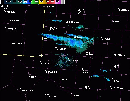
Here is a NWS Midland doppler radar image taken roughly around 4:30 pm CST (3:30 pm MST). The weak echoes you see across the northern Permian Basin is actually the plume of dust, and smoke from wildfires in Lea County N.M., that was spreading over these locations.
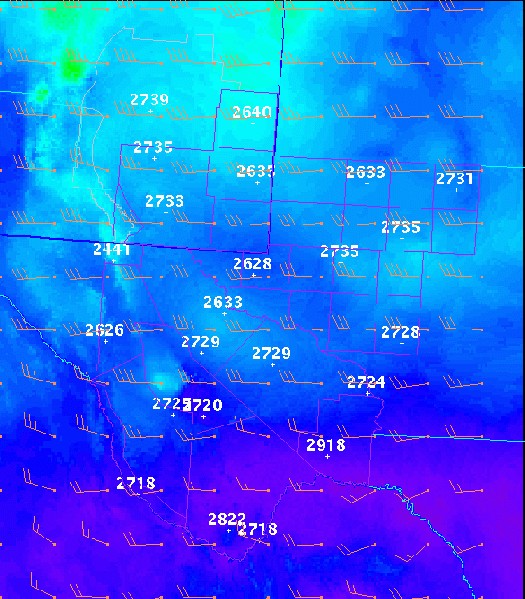
This graphic, which was processed locally on our Graphical Forecast Editor software, shows sustained wind speeds at 3 pm CST (2 pm MST) Sunday afternoon. As you can see, sustained surface wind speeds ranged from 30-35 mph, with higher gusts. The strongest wind speeds affected areas from the Guadalupe mountains, the southeastern plains of New Mexico, and the northern Permian Basin.
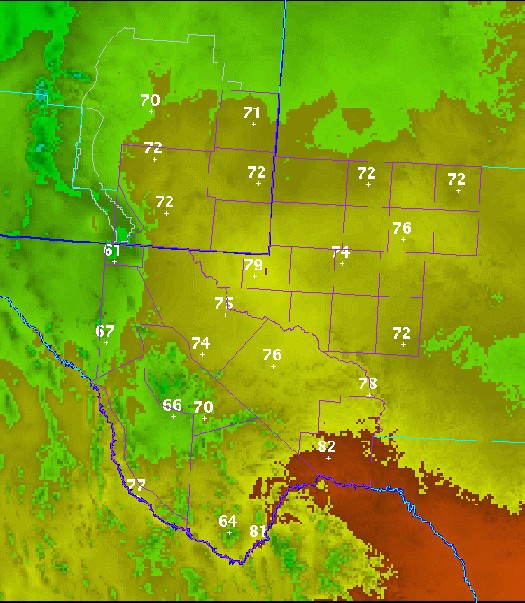
Here is a graphic illustrating surface temperatures at 3 pm CST (2 pm MST) Sunday. As you can see, temperatures were very warm, mostly in the 70s across a good portion of the region.
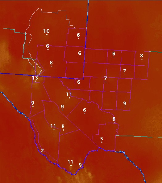
With the very warm temperatures, and the very dry air in place, relative humidity values were very low. This graphic illustrates the relative humidity values in percent. Most locations had relative humidity values less than 10 percent!
All of these conditions combined to produce very dangerous conditions regarding fire growth and spread. One of the most damaging fires occurred just west of the community of Tatum in northern Lea county New Mexico. These fires were reportedly generated by downed power lines due to the high winds. The strong winds fueled the flames eastward, and residents in Tatum were briefly evacuated as the fire approached within 2 miles of the city limits. The fire ended up burning more than 30,000 acres of land. Other damaging fires broke out near Buckeye and Hobbs.
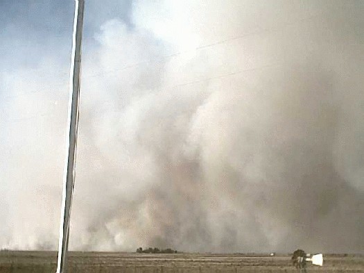
A massive plume of smoke rises from the raging fire west of Tatum. Image courtesy of James Hale.
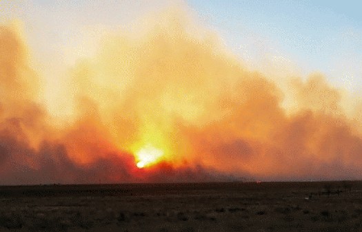
Another view of the fire about 4 miles west of Tatum. Image courtesy of Nathan Good.
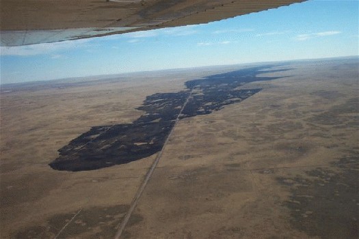
An aerial photo showing the remnants of the fire. Image courtesy of James Hale and Michael Cunningham.

