
A slow moving front extending from the Great Lakes region into the Plains will bring snow, wintry mix, and ice accumulation north of the front from the Upper Midwest into New England, and severe weather and heavy rain south of the front. Scattered severe thunderstorms with damaging gusts, severe hail, and heavy rain are expected across parts of the Great Lakes/Midwest through tonight. Read More >
Extremely heavy rainfall in eastern Terrell County resulted in record flooding along the Independence and Dry Creeks. Radar estimates of rainfall in north central Terrell County reached as high as between 11 and 12 inches. This flooding produced damage to homes and Texas Highway 349 in eastern Terrell County. In addition, Independence Creek set a record crest east of Texas Highway 349 on Sunday, July 25th, of 18.31 feet. The previous record of 17.95 feet was set in 1974. While rising to this crest, the creek rose 15 feet in less than 2 hours. According to the USGS in San Angelo, the estimated discharge at the Chandler Ranch guage site created by this flooding was 78,000 cfs (cubic feet per second). The normal discharge is estimated to be 40 cfs.
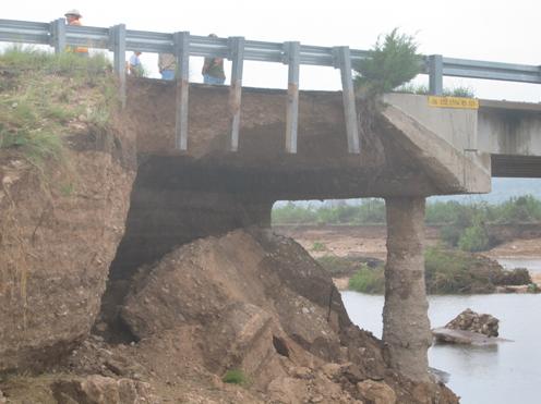
Damage to the northern end of the Dry Creek Bridge on the up-creek side.
The next several pictures show some of the damage observed in Terrell County from this devastating flash flood. Some of the pictures were taken from the Chandler Ranch along Independence Creek, and some were taken along Texas Highway 349 south of both Sheffield and the intersection of TX 349 and FM 2400. The worst damage from this flood was seen near the Dry Creek and along Texas Highway 349 as it runs parallel with Dry Creek. The damage to the Chandler Ranch is along Independence Creek below where Dry Creek empties into Independence Creek.

This picture shows where a stretch of approximately 300 feet of asphalt has been peeled off of TX 349 just before the Dry Creek Bridge by the rushing floodwaters.

This image shows some of the debris left behind by the flood on and near the Dry Creek Bridge on TX 349.

A view of the most heavily damaged northern end of Dry Creek Bridge from the down creek side.

Debris left on the Dry Creek Bridge from the 18 foot wall of water.

Debris can be seen in the guardrails of the bridge over Dry Creek. This shows that the water was clearly running over the top of the bridge.

This is an image of the less extensive damage done to the south side of the Dry Creek Bridge.

An image of what is believed to be Independence Creek during the flooding as it runs under TX 349 on Sunday, July 25th.

An image of asphalt peeled up by the flood along TX 349 between FM 2400 and the Dry Creek Bridge.

This picture shows a layer of earth, rocks and other debris approximately 4 feet deep swept over TX 349 by water rushing into Dry Creek as it flows parallel to TX 349.

This image shows the cracked foundation of the house due to the high floodwaters.

This image shows the light post that was bent over by the strength of the flood waters. Debris carried by the rushing water can be seen in the pool, and also wrapped around trees in the yard.

This pictures shows debris deposited by the flood as the water moved over the property. Independence Creek normally flows about 50 feet behind the vantage point of this photograph.

This picture shows how high the floodwaters rose into the yard of the house along Independence Creek. The line of leaves shows the estimated high water mark, clearly indicating that the water was into the house.

