
Severe thunderstorms are forecast through this weekend along a slow moving cold front and secondary storm system that will impact areas from the southern Plains to the Great Lakes. Large hail and isolated damaging wind gusts are the main threats with these storms along with a risk for heavy to excessive rainfall which could bring flooding. Read More >
Record flooding, tornadoes, and severe thunderstorms associated with 3 to 4 days of thunderstorms and heavy rain occurred over West Texas and southeastern New Mexico between April 2 and April 4. A powerful upper level low pressure system located in southwestern Arizona from Thursday, April 1 through Monday, April 5 played a major role in the development of thunderstorms over the Midland County Warning Area (CWA). A series of mid and upper level disturbances rounded the base of the low and tracked across the WFO Midland CWA during the first week in April. Near the surface, moist, easterly upslope flow helped feed abundant amounts of moisture into the area. Intensification of thunderstorms was noted in areas of locally maximized instability and upper level diffluent flow, and closely coincided with the timing of mid-level shortwave troughs crossing the area.
During this severe weather outbreak, the National Weather Service in Midland was in close contact with emergency management and other officials within our county warning area. It was only through the dedicated teamwork of emergency management, state and local law enforcement personnel, the media, the amateur radio community, SKYWARN spotters, firefighters, EMS personnel, the National Weather Service, and many other groups working together that these early April severe weather events resulted in no direct fatalities. We are accustomed to severe weather during the springtime across West Texas and southeastern New Mexico. However, the extreme nature of these events within such a short span of time, make the severe weather episodes of April 2004 quite historic.
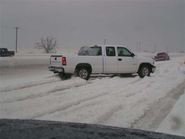
Thunderstorms developed over Lea County, New Mexico during Saturday afternoon on April 3. The most notable of these thunderstorms was a supercell thunderstorm that developed near Eunice at 3:36 PM and moved northeast into Gaines County. This storm moved slowly northeast across western portions of Gaines County, crossing Highway 62/180 from 15 miles west of Seminole to the New Mexico border.
Due to the slow storm movement and the large size of the storm, higher intensities stayed over Highway 62/180 from 3:54 PM to 5:00 PM. This resulted in up to 1 ½ feet of hail accumulation and the closing of Highway 62/180. Below is a photo from this hail event taken during the late afternoon on April 3.
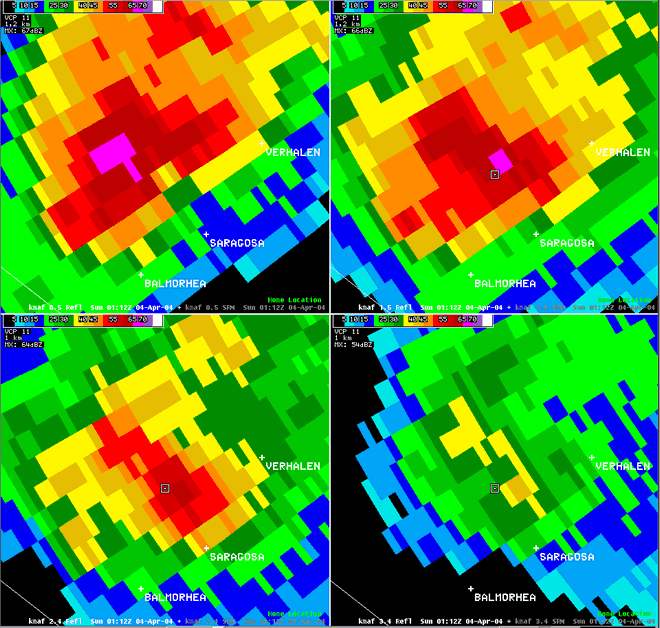
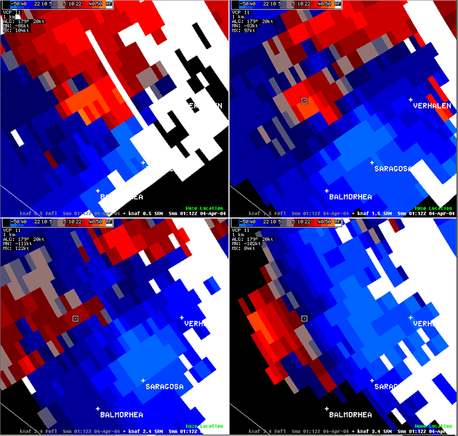
Two more supercell thunderstorms developed after the initial storm moved north of Gaines County. One storm formed in extreme northwestern Andrews County, and moved into southwestern Gaines County just after 6:00 PM. The second thunderstorm produced a brief tornado at 7:05 PM, thirteen miles southwest of Seminole. No damage was reported with this tornado. This thunderstorm continued to produce funnel clouds as it slowly drifted to the north over Gaines County. The third thunderstorm developed over eastern Lea County in New Mexico by 7:00 PM CST, causing flash flooding in Lea County and nickel size hail in Eunice, NM.
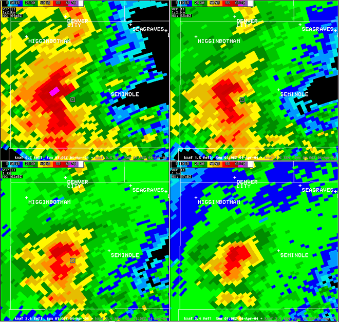
Reflectivity radar image of tornadic thunderstorms over western Gaines county.
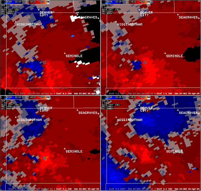
Storm relative velocity radar image of tornadic thunderstorms over western Gaines county.
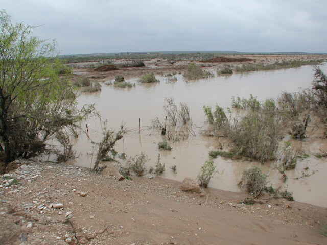
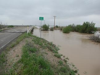
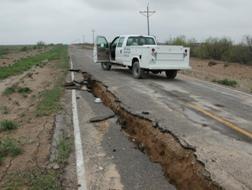
Flash flooding of Salt Draw near Toyah, TX (west of Pecos) caused the failure of a protective levee around Toyah, extensive flooding of most homes and property in Toyah, and the destruction of the I-20 bridge over Salt Draw between Toyah and Pecos, TX in Reeves County. Indirectly, 5 lives were also lost in a weather related traffic accident on U.S. Hwy. 285 south of Pecos, which was being used as a detour because of the bridge failure.
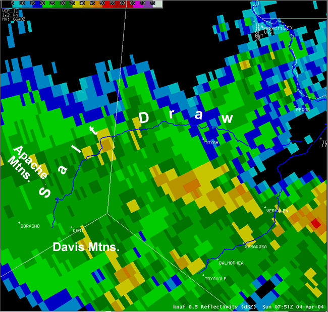
This radar image shows widespread rain over the Davis and Apache mountains as well as western Reeves county. Notice how Salt Draw originates at the foothills of the Davis and Apache mountains.
The weather-related fatalities in West Texas occurred in a four-vehicle wreck at about 4:30 a.m. on U.S. Hwy. 285 in southeastern Reeves County, according to the Texas Department of Public Safety. That two-lane highway was used as a detour for eastbound traffic on I-20 after a bridge over the normally dry Salt Draw was washed away Sunday evening by fast-moving water that had broken an upstream dam earlier in the day. No one was hurt when the I-20 bridge crumbled into the Salt Draw about 15 miles west of Pecos. Authorities said they had advance warning that the collapse was coming and were able to close the road to both eastbound and westbound traffic.
Bill Powell, a spokesman for the Texas Department of Transportation in Austin, said that about 80 feet of roadway in the eastbound lanes fell into the river, and that additional 40-foot segments on each side of the river were also damaged. On the westbound side, Powell said one of the upright supports holding up the bridge had moved six to eight inches, opening a crack in the roadway. He said TxDOTengineers were assessing the extent of the damage. "The water below the bridge looks like the Mississippi -- strong, muddy-brown currents," he said. "It's very strong under the bridge."
The following are images from this catastrophic weather event that impacted Reeves County.
This section of protective levee around Toyah washed out causing flash flooding through the town. The levee was built in 1940 to protect the town from flooding. A debris line exists along remaining sections of the levee very near the top, suggesting that the failure was caused by water going over the top.
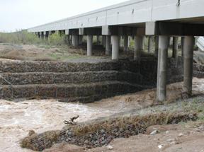
This bridge over Salt Draw is immediately downstream of the point of failure in the levee. This bridge was most likely a contributing cause of the failure as it acted as a dam across Salt Draw during high flow. Although water flowed around the bridge through a wide low lying section to it’s north, one cannot help but notice that the point of failure was immediately upstream of the bridge.
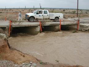
This bridge was about ½ mile downstream of the other bridge at the point of levee failure. Looking at the high water debris line, it was obvious that even this lower profile bridge was acting as a dam. The high water mark was within 6 inches of topping the levee at this point. One can only speculate as to whether the levee would have been topped if the bridge were not existent or if both were of this lower profile.
A faint line across the road near the top of the levee indicates the high water debris line. Note it sloped downward to the left or downstream side of the bridge.
Another view of the section of levee that failed
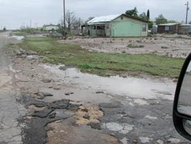
This is a typical home in Toyah. Most buildings in Toyah experienced 2 to 4 feet of muddy flood waters. We were told that almost all of the cities dumpsters, spare lumber, and everything else outside was washed downstream and lost.
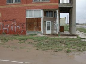
Note the high-water mark on brick (dark section lower left) on an old bank building in downtown Toyah.
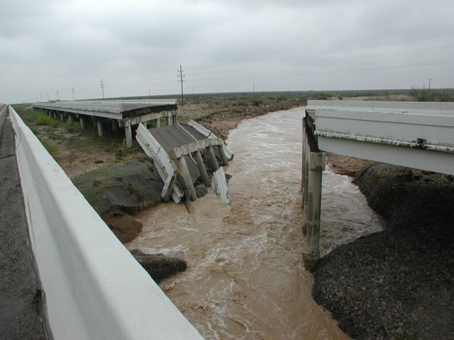
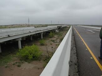
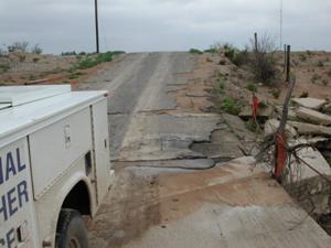
Collapsed east bound lane of I-20 bridge between Toyah and Pecos over Salt Draw
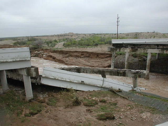
Notice the middle bridge support is tilted and lower than the others
In the next 3 photos, notice the drop in the stream level as it enters the bridge area. It is believe the rock embankment caused a hydrologic jump with associated standing wave, which undermined the bridge supports and very significantly deepened the channel through the bridge area. It should be noted that the high watermark line was well below the bridge level. At the ends of the bridge area, it was up about 1 foot on the concrete embankment at the west end.
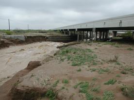
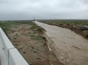
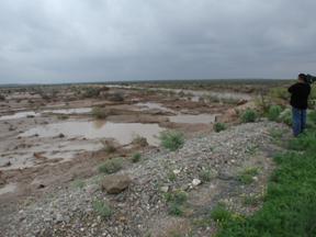
This is a view of Salt Draw upstream from the bridge. This wash is normally dry. The photo was taken the day after the bridge collapsed.
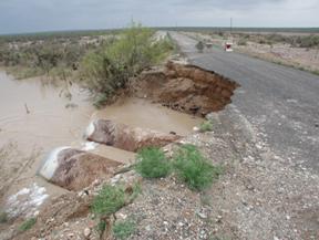
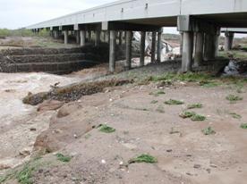
This is Salt Draw crossing a county road southwest of Pecos, TX (downstream from the bridge collapse).
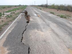
A sinkhole was beginning to open up along this county road southwest of Pecos.
In addition to the flooding near Toyah, a tornado was reported a few miles northwest of Balmorhea around 7:17 pm. See the radar imagery of this torm below.
Reflectivity image at four elevations of tornadic thunderstorm over Reeves County.
Storm-relative velocity image at four elevations of tornadic thunderstorm over Reeves County.
In addition, this supercell thunderstorm near Verhalen likely produced large hail as it moved across southern Reeves county.
Reflectivity image at four elevations of severe thunderstorm producing hail over Reeves County.
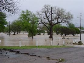
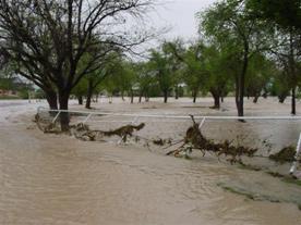
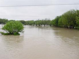
A high precipitation supercell formed in extreme southwestern Pecos County early in the morning on Sunday, April 4th, and moved to the northeast, eventually affecting Fort Stockton. This thunderstorm produced extremely heavy rainfall, very high wind gusts (80 mph estimated), hail up to the size of golfballs, and flooding as it moved across the city of Fort Stockton. Several areas of Fort Stockton were affected by the storm. One of the hardest hit areas was the James Rooney Memorial Park. Comanche Creek, which runs through this park, was well out of its banks as can be seen in the following pictures. The radar imagery and loop shows that the most intense reflectivities of the storm went over the southeastern half of the city, which is where the park is located.
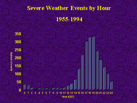
The storm hit the Fort Stockton area at around 5 AM CDT. While possible, early morning severe weather events are quite rare across West Texas and southeastern New Mexico. The following chart shows a 40-year climatology of severe weather events for this area broken down by hour of the day.
The following are some images from James Rooney Memorial Park in Fort Stockton showing the extent of the flooding that occurred. Photos are courtesy of Ron M. in Fort Stockton.
In a rare early morning event such as this, receiving warning information can be very difficult. When people are asleep, radios and televisions are often turned off. Additionally, loss of power can result in the loss of key weather information during an event. Having NOAA Weather Radio (NWR) with a battery backup can make a huge impact by providing a tone alert, which allows for those that are sleeping to awaken and receive vital life saving information.
Currently, Reeves County, adjacent to Pecos County, is in the process of applying for a Rural Utility Services Grant Program through the USDA to fund the installation of a NOAA Weather Radio transmitter in Reeves County. If approved and installed, this NOAA Weather Radio system will not only provide key information to the communities of Pecos, Saragosa, and Balmorhea, but also provide coverage in the Fort Stockton area.
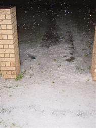
Here are additional photos showing some of the hail that fell during this rare early morning severe weather event.

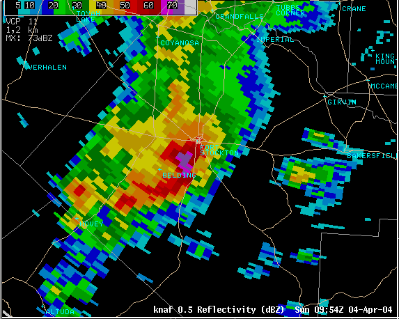
This radar image shows the severe thunderstorm as it moves into the Fort Stockton area.
The Eddy County flood survey revealed that three different factors contributed to the record flooding in and near Carlsbad. Floodwaters from Rocky Arroyo Draw fed into the Pecos River north of Avalon Reservoir. This flow along with heavy rainfall from thunderstorms resulted in a required release of water from the Avalon Reservoir. Radar estimated rainfall totals of 3 to 4 inches fell near and west of Avalon Reservoir between 900 PM MST on April 3rd through 100 AM MST on Sunday, April 4th. Releases from the reservoir began near 800 PM MST on April 3rd, with a measured peak rate of 14,800 cfs (cubic-feet per second) at around 400 AM MDT Sunday morning. This release of water eliminated the potential danger of a dam failure, but resulted in the washout of Callaway Drive just downstream from the release point on Avalon Reservoir. The following pictures are of the main release point of Avalon Reservoir and the effects of the release on Callaway Drive.
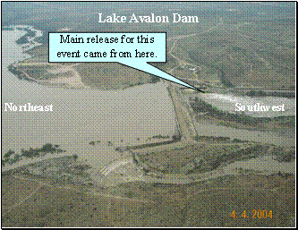
Figure 1. Avalon Reservoir
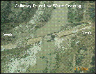
Figure 2. Pecos River washing our Callaway Drive
The second factor contributing to the record flooding was extremely high flow through the Dark Canyon Draw into downtown Carlsbad. Radar estimated rainfall of 1 to 3 inches fell over and southwest of Dark Canyon during the evening and overnight hours of Saturday April 3rd. This rainfall led to catastrophic flash flooding along the Dark Canyon Draw from southwest portions of Carlsbad into the downtown area. A wall of water moved down Dark Canyon Draw at approximately 1:30 AM MST Sunday morning. The pictures below show some of the effects of the flooding. The first picture shows a water tanker that flowed down Dark Canyon Draw, and eventually was pushed up against the Atchison Topeka and Santa Fe Railroad Bridge just east of Highway 285 bridge. The second picture shows the washout of Hidalgo Road at Dark Canyon Draw. The third picture shows the washout of Boyd Drive at Dark Canyon Draw.
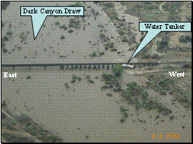
Figure 3. Dark Canyon flowing across railroad bridge.

Figure 4. Dark Canyon Draw flowing across Hidalgo Road
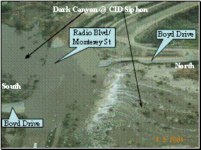
Figure 5. Dark Canyon Draw washing out Boyd Drive.
The third factor that contributed to the flooding was the failure at several points of the CID (Carlsbad Irrigation District) canals. These CID channels, used primarily to irrigate areas alfalfa fields, began failing due to runoff from the 8-12 inches of rainfall over the three days crossing perpendicular to the CID channels. Erosion of the channels began occurring due to the high volume of water flowing over them. As the channels finally failed, water flowed into adjacent neighborhoods. The community hardest hit by this runoff was the La Huerta neighborhood in northeastern Carlsbad. The following picture shows the major points at which the CID canals were breached and allowed water to flow through the La Huerta neighborhood. As a result of this flooding, 6 to 12 inches of water was left standing throughout most of the La Huerta area with higher amounts at isolated points.
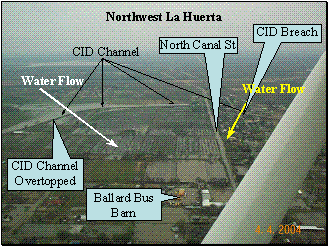
Figure 6.
PRELIMINARY LOCAL STORM REPORT
NATIONAL WEATHER SERVICE MIDLAND/ODESSA TX
106 AM CST SAT APR 03 2004

..TIME...   ...EVENT...     ...CITY LOCATION...      ...LAT.LON...
..DATE...   ....MAG....     ..COUNTY LOCATION...ST.. ...SOURCE....
            ..REMARKS..

1115 PM     HAIL             CARLSBAD                32.40N 104.24W
04/02/2004  1.00 INCH        EDDY               NM   PUBLIC

1123 PM     HAIL             CARLSBAD                32.40N 104.24W
04/02/2004  1.25 INCH        EDDY               NM   TRAINED SPOTTER

            QUARTER TO HALF DOLLAR SIZED HAIL COVERING THE GROUND IN
            CARLSBAD.

1136 PM     HAIL             CARLSBAD                32.40N 104.24W
04/02/2004  0.88 INCH        EDDY               NM   TRAINED SPOTTER

1140 PM     FLOOD            CARLSBAD                32.40N 104.24W
04/02/2004                   EDDY               NM   TRAINED SPOTTER

            1 FOOT OF WATER REPORTED COVERING CITY STREETS IN
            CARLSBAD.

1140 PM     HAIL             CARLSBAD                32.40N 104.24W
04/02/2004  1.75 INCH        EDDY               NM   PUBLIC

            GOLFBALL SIZED HAIL.

1140 PM     HAIL             CARLSBAD                32.40N 104.24W
04/02/2004  1.50 INCH        EDDY               NM   TRAINED SPOTTER

            QUARTER TO PING PONG BALL SIZED HAIL COVERING THE GROUND.


1145 PM     FLOOD            CARLSBAD                32.40N 104.24W
04/02/2004                   EDDY               NM   TRAINED SPOTTER

            4 FEET OF WATER COVERING THE STREETS IN CARLSBAD.

1205 AM     FLOOD            10 WSW CARLSBAD         32.35N 104.39W
04/03/2004                   EDDY               NM   LAW ENFORCEMENT

            ROADS REPORTED TO BE IMPASSABLE DUE TO HIGH WATER ON DARK
            CANYON ROAD.

1205 AM     HAIL             10 WSW CARLSBAD         32.35N 104.39W
04/03/2004  1.00 INCH        EDDY               NM   LAW ENFORCEMENT

            QUARTER SIZED HAIL ON DARK CANYON ROAD.


&&

$$


PRELIMINARY LOCAL STORM REPORT
NATIONAL WEATHER SERVICE MIDLAND/ODESSA TX
1252 AM CST SUN APR 04 2004

..TIME...   ...EVENT...     ...CITY LOCATION...      ...LAT.LON...
..DATE...   ....MAG....     ..COUNTY LOCATION...ST.. ...SOURCE....
            ..REMARKS..

0422 AM     HAIL             20 SW TOYAH             31.11N 104.03W
04/03/2004  4.25 INCH        REEVES             TX   LAW ENFORCEMENT

0445 PM     HAIL             10 W PAYNES CORNER      32.73N 102.97W
04/03/2004  0.75 INCH        GAINES             TX   AMATEUR RADIO

0450 PM     HAIL             10 E PRESIDIO           29.56N 104.20W
04/03/2004  1.00 INCH        PRESIDIO           TX   LAW ENFORCEMENT

0508 PM     HAIL             36 NW FORT DAVIS        30.96N 104.33W
04/03/2004  1.75 INCH        JEFF DAVIS         TX   LAW ENFORCEMENT

0508 PM     HAIL             15 W TOYAH              31.32N 104.05W
04/03/2004  1.75 INCH        REEVES             TX   LAW ENFORCEMENT

0525 PM     HAIL             LAJITAS                 29.26N 103.77W
04/03/2004  0.75 INCH        BREWSTER           TX   TRAINED SPOTTER

0535 PM     HAIL             20 W SEMINOLE           32.72N 103.00W
04/03/2004  2.75 INCH        GAINES             TX   LAW ENFORCEMENT

0547 PM     HAIL             LAJITAS                 29.26N 103.77W
04/03/2004  4.25 INCH        BREWSTER           TX   PUBLIC

0547 PM     HAIL             20 SW MARFA             30.11N 104.26W
04/03/2004  1.00 INCH        PRESIDIO           TX   PUBLIC

0555 PM     HAIL             VALENTINE               30.59N 104.50W
04/03/2004  0.88 INCH        JEFF DAVIS         TX   TRAINED SPOTTER

0615 PM     HAIL             6 W TOYAH               31.32N 103.90W
04/03/2004  1.00 INCH        REEVES             TX   PUBLIC

0635 PM     FLASH FLOOD      HOBBS                   32.73N 103.16W
04/03/2004                   LEA                NM   LAW ENFORCEMENT

            HIGHWAY 62/180 HOBBS TO SEMINOLE AND HIGHWAY 18 HOBBS TO
            EUNICE CLOSED DUE TO FLOODING

0637 PM     HAIL             EUNICE                  32.44N 103.19W
04/03/2004  0.88 INCH        LEA                NM   TRAINED SPOTTER

0705 PM     TORNADO          13 SW SEMINOLE          32.59N 102.81W
04/03/2004                   GAINES             TX   TRAINED SPOTTER

            CONFIRMED TORNADO MOVING NORTHEAST 15 MPH TOWARD SEMINOLE


0717 PM     TORNADO          2 NW BALMORHEA          31.00N 103.77W
04/03/2004                   REEVES             TX   LAW ENFORCEMENT

            CONFIRMED TORNADO MOVING EAST AT 10 MPH

0751 PM     TORNADO          5 SW PECOS              31.36N 103.56W
04/03/2004                   REEVES             TX   LAW ENFORCEMENT

            CONFIRMED TORNADO MOVING NORTHEAST 1O MPH TOWARD PECOS

0809 PM     FUNNEL CLOUD     5 SW SEMINOLE           32.67N 102.71W
04/03/2004                   GAINES             TX   PUBLIC

            NUMEROUS REPORTS OF FUNNEL CLOUD OR UNCONFIRMED TORNADO

0810 PM     HAIL             8 W EUNICE              32.44N 103.33W
04/03/2004  0.75 INCH        LEA                NM   FIRE DEPT/RESCUE

0810 PM     FLASH FLOOD      EUNICE                  32.44N 103.19W
04/03/2004                   LEA                NM   LAW ENFORCEMENT

            ALL ROADS LEADING OUT OF EUNICE CLOSED DUE TO FLOODING

0834 PM     HAIL             15 S PECOS              31.20N 103.50W
04/03/2004  1.75 INCH        REEVES             TX   LAW ENFORCEMENT

0835 PM     HAIL             15 SW SEMINOLE          32.56N 102.83W
04/03/2004  1.00 INCH        GAINES             TX   TRAINED SPOTTER

            FUNNEL CLOUDS ALSO REPORTED BY SPOTTERS


&&

$$


PRELIMINARY LOCAL STORM REPORT
NATIONAL WEATHER SERVICE MIDLAND/ODESSA TX
506 PM CDT SUN APR 04 2004

..TIME...   ...EVENT...     ...CITY LOCATION...      ...LAT.LON...
..DATE...   ....MAG....     ..COUNTY LOCATION...ST.. ...SOURCE....
            ..REMARKS..

0940 PM     FLASH FLOOD      12 NW WHITES CITY       32.18N 104.38W
04/03/2004                   EDDY               NM   OFFICIAL NWS OBS

            DARK CANYON ROAD 5 MILES EAST OF HIGHWAY 137 UNDER 7 FEET
            OF WATER.

0940 PM     FLASH FLOOD      CARLSBAD                32.40N 104.24W
04/03/2004                   EDDY               NM   OFFICIAL NWS OBS

            SEVERAL ROADS IN THE CARLSBAD AREA UNDER WATER.

1035 PM     FLASH FLOOD      10 N BALMORHEA          31.13N 103.74W
04/03/2004                   REEVES             TX   EMERGENCY MNGR

            FLOODING ALONG PORTONS OF FM 2903 BETWEEN TOYAH AND
            BALMORHEA WITH ROAD IMPASSABLE.

1210 AM     FLASH FLOOD      7 SSE SEVEN RIVERS      32.51N 104.37W
04/04/2004                   EDDY               NM   OFFICIAL NWS OBS

            HIGHWAY 285 IMPASSABLE BETWEEN CARLSBAD AND ARTESIA.

0123 AM     HAIL             5 ENE ALPINE            30.39N 103.59W
04/04/2004  1.75 INCH        BREWSTER           TX   LAW ENFORCEMENT

            REPORTED BY SHERIFFS OFFICE

0300 AM     FLASH FLOOD      7 WSW PECOS             31.39N 103.61W
04/04/2004                   REEVES             TX   LAW ENFORCEMENT

            FLOODING OCCURRING ALONG FM 869.

0300 AM     FLASH FLOOD      TOYAH                   31.32N 103.79W
04/04/2004                   REEVES             TX   LAW ENFORCEMENT

            DIKE BROKE NEAR TOYAH RESULTING IN MAJOR FLOODING AND
            EVACUATION. WATER WAIST DEEP IN SOME HOMES. FLASH
            FLOODING ALSO OCCURRING ALONG FM 2903 NEAR TOYAH.

0330 AM     HAIL             25 W FORT STOCKTON      30.94N 103.30W
04/04/2004  0.88 INCH        PECOS              TX   LAW ENFORCEMENT

0335 AM     HAIL             1 SE HOVEY              30.59N 103.33W
04/04/2004  1.75 INCH        PECOS              TX   LAW ENFORCEMENT

            REPORTED BY SHERIFFS DEPUTY

0410 AM     FLASH FLOOD      8 SW CARLSBAD           32.32N 104.32W
04/04/2004                   EDDY               NM   LAW ENFORCEMENT

            EVACUATIONS DUE TO FLOODING ALONG COUNTY ROADS 658 AND
            672 SOUTHWEST OF CARLSBAD.

0459 AM     HAIL             FORT STOCKTON           30.89N 102.89W
04/04/2004  1.75 INCH        PECOS              TX   LAW ENFORCEMENT

0500 AM     HAIL             FORT STOCKTON           30.89N 102.89W
04/04/2004  1.75 INCH        PECOS              TX   LAW ENFORCEMENT

0510 AM     HAIL             FORT STOCKTON           30.89N 102.89W
04/04/2004  1.00 INCH        PECOS              TX   PUBLIC

            QUARTER TO GOLFBALL SIZED HAIL REPORTED BY THE PUBLIC FOR
            A 10 MINUTE DURATION. REPORTS OF HAIL UP TO 3 INCHES IN
            DEPTH ON ROADWAYS.

0515 AM     TSTM WND GST     FORT STOCKTON           30.89N 102.89W
04/04/2004  80 MPH           PECOS              TX   LAW ENFORCEMENT

            REPORTED BY A SHERIFFS DEPUTY

0625 AM     FLASH FLOOD      5 ENE BELDING           30.83N 102.95W
04/04/2004                   PECOS              TX   LAW ENFORCEMENT

            OLD ALPINE HIGHWAY CLOSED. ROAD CLOSED BETWEEN FORT
            STOCKTON TO BELDING.

0838 AM     HAIL             FORT DAVIS              30.59N 103.90W
04/04/2004  0.88 INCH        JEFF DAVIS         TX   PARK/FOREST SRVC

0900 AM     FLASH FLOOD      NADINE                  32.62N 103.13W
04/04/2004                   LEA                NM   LAW ENFORCEMENT

            HIGHWAY 18 BETWEEN EUNICE AND HOBBS CLOSED DUE TO
            FLOODING.

0930 AM     FLASH FLOOD      4 WSW PAYNES CORNER     32.73N 102.80W
04/04/2004                   GAINES             TX   EMERGENCY MNGR

            FLOODING AT THE INTERSECTION OF COUNTY ROAD 331 AND
            HIGHWAY 180 AT SEMINOLE DRAW.

1020 AM     FLASH FLOOD      PECOS                   31.41N 103.50W
04/04/2004                   REEVES             TX   LAW ENFORCEMENT

            FLOODING REPORTED ALONG HIGHWAY 285.

1027 AM     FLASH FLOOD      BARSTOW                 31.46N 103.39W
04/04/2004                   WARD               TX   LAW ENFORCEMENT

            FLOODING REPORTED IN BARSTOW.

1125 AM     FLASH FLOOD      4 WSW THORNTONVILLE     31.56N 102.99W
04/04/2004                   WARD               TX   LAW ENFORCEMENT

            FLOODING REPORTED AT THE JUNCTION OF FM 1219 AND
            INTERSTATE 20.

1203 PM     FLASH FLOOD      4 SW CARLSBAD           32.36N 104.29W
04/04/2004                   EDDY               NM   OFFICIAL NWS OBS

            FLOODING OF LOW LYING AREAS AROUND CARLSBAD CONTINUING
            ALONG THE PECOS RIVER...DARK CANYON DRAW...DAGGER
            DRAW...HACKBERRY DRAW...AND HIGBY HOLE...


&&

$$


PRELIMINARY LOCAL STORM REPORT
NATIONAL WEATHER SERVICE MIDLAND/ODESSA TX
852 PM CDT SUN APR 04 2004

..TIME...   ...EVENT...     ...CITY LOCATION...      ...LAT.LON...
..DATE...   ....MAG....     ..COUNTY LOCATION...ST.. ...SOURCE....
            ..REMARKS..

0110 PM     FLASH FLOOD      PECOS                   31.41N 103.50W
04/04/2004                   REEVES             TX   LAW ENFORCEMENT

            HWY 17, 2903, 869, AND 1450 CLOSED DUE TO FLOODING.

0143 PM     FLASH FLOOD      NE ODESSA               31.85N 102.37W
04/04/2004                   ECTOR              TX   LAW ENFORCEMENT

            ALL LOW LYING AREAS IN NE ODESSA TO W ODESSA ARE FLOODED.


0145 PM     FLASH FLOOD      18 W SEMINOLE           32.72N 102.96W
04/04/2004                   GAINES             TX   TRAINED SPOTTER

            FLOODING ACROSS WCS GUARDHOUSE, WATER FLOWING FAST.

0210 PM     FLASH FLOOD      7 SW SEMINOLE           32.65N 102.74W
04/04/2004                   GAINES             TX   LAW ENFORCEMENT

            WATER OVER THE ROAD ON HWY 181. ALSO COUNTY ROAD 308,
            COUNTY ROAD 331, COUNTRY ROAD 347 FLOODED.

0230 PM     FLASH FLOOD      MIDLAND                 32.00N 102.08W
04/04/2004                   MIDLAND            TX   TRAINED SPOTTER

            S.MIDKIFF FROM ANDREWS BLVD TO WALL ST WATER RUNNING CURB
            TO CURB. MIDLAND DR AND LOOP 250 FLOODED.

0333 PM     FLASH FLOOD      W SEMINOLE              32.72N 102.65W
04/04/2004                   GAINES             TX   CO-OP OBSERVER

            SEVERAL FEET OF WATER RUNNING OVER FIELD ROADS IN WESTERN
            ANDREWS COUNTY.

0415 PM     FLASH FLOOD      3 W MIDLAND             32.00N 102.13W
04/04/2004                   MIDLAND            TX   NWS EMPLOYEE

            PORTIONS OF HWY 80 FLOODED WITH WATER RUNNING OVER HWY.


&&

$$


PRELIMINARY LOCAL STORM REPORT
NATIONAL WEATHER SERVICE MIDLAND/ODESSA TX
349 PM CDT MON APR 05 2004

..TIME...   ...EVENT...     ...CITY LOCATION...      ...LAT.LON...
..DATE...   ....MAG....     ..COUNTY LOCATION...ST.. ...SOURCE....
            ..REMARKS..

0235 PM     HAIL             4 W FORT DAVIS          30.59N 103.97W
04/05/2004  0.88 INCH        JEFF DAVIS         TX   PARK/FOREST SRVC

0240 PM     HAIL             20 NW MARFA             30.51N 104.26W
04/05/2004  0.88 INCH        JEFF DAVIS         TX   OTHER FEDERAL


&&

$$

PRELIMINARY LOCAL STORM REPORT
NATIONAL WEATHER SERVICE MIDLAND/ODESSA TX
945 PM CDT MON APR 05 2004

..TIME...   ...EVENT...     ...CITY LOCATION...      ...LAT.LON...
..DATE...   ....MAG....     ..COUNTY LOCATION...ST.. ...SOURCE....
            ..REMARKS..

0504 PM     HAIL             4 N STUDY BUTTE         29.39N 103.53W
04/05/2004  0.75 INCH        BREWSTER           TX   NWS EMPLOYEE

            STORM CROSSED HIGHWAY 118.

0515 PM     HAIL             BALMORHEA               30.98N 103.74W
04/05/2004  1.75 INCH        REEVES             TX   PUBLIC

            PECOS COUNTY SHERIFF REPORTED AT 915 PM LOCAL TIME THAT
            FM 1450 FROM COYANOSA TO PECOS IS CLOSED DUE TO STANDING
            WATER AND HAIL STILL ON THE ROAD.

0557 PM     HAIL             GREENWOOD               32.03N 101.90W
04/05/2004  0.88 INCH        MIDLAND            TX   TRAINED SPOTTER

0620 PM     TSTM WND GST     HEATH CANYON            29.45N 102.82W
04/05/2004  70 MPH           BREWSTER           TX   CO-OP OBSERVER

0620 PM     HAIL             HEATH CANYON            29.45N 102.82W
04/05/2004  4.00 INCH        BREWSTER           TX   CO-OP OBSERVER

            HOUSE WINDOWS AND CARS WERE HEAVILY DAMAGED.

0920 PM     FLASH FLOOD      BIG SPRING              32.25N 101.48W
04/05/2004                   HOWARD             TX   LAW ENFORCEMENT

            HEAVY RAINS FORCED ROAD CLOSURES INSIDE TOWN.


&&

$$


PRELIMINARY LOCAL STORM REPORT
NATIONAL WEATHER SERVICE MIDLAND/ODESSA TX
1124 PM CDT MON APR 05 2004

..TIME...   ...EVENT...     ...CITY LOCATION...      ...LAT.LON...
..DATE...   ....MAG....     ..COUNTY LOCATION...ST.. ...SOURCE....
            ..REMARKS..

1000 PM     FLASH FLOOD      7 N WESTBROOK           32.46N 101.01W
04/05/2004                   MITCHELL           TX   TRAINED SPOTTER

            SIX INCHES OF WATER ON FM 1229

1013 PM     FLASH FLOOD      HERMLEIGH               32.64N 100.76W
04/05/2004                   SCURRY             TX   FIRE DEPT/RESCUE

            ROADS IN TOWN COVERED WITH WATER.

1028 PM     FLASH FLOOD      SNYDER                  32.71N 100.92W
04/05/2004                   SCURRY             TX   TRAINED SPOTTER

            UP TO 18 INCHES OF WATER ON AVEENUE E. CITY CLOSING SOME
            STREETS.

1050 PM     FLASH FLOOD      6 SE HERMLEIGH          32.58N 100.69W
04/05/2004                   SCURRY             TX   LAW ENFORCEMENT

            WATER AND DEBRIS RUNNING ACROSS HWY 84.


&&

$$

