
Unseasonably warm temperatures continue today across the southern U.S., with more than 100 record or near record maximum temperatures forecast through the rest of the week and over the weekend. Dry and gusty winds will produce elevated to critical fire weather in the central and southern Plains and elevated conditions over portions of the Desert Southwest on Friday. Read More >
A series of severe thunderstorms moved through the extreme southern portions of the South Plains and the northern portions of the Texas Permian Basin late Sunday September 7th and early Monday morning on September 8th. These storms produced a variety of severe weather across WFO Midland’s County Warning Area. The following is a summary of findings from the WFO Midland Damage Survey Team.
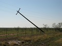
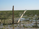
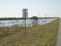
The majority of the damage occurred in Dawson, Martin, and Andrews counties. Martin County and eastern portions of Andrews County experienced high winds and flooding. There were an estimated 38 power poles either damaged or destroyed across these counties. This damage was concentrated near the intersection of Highway 349 and 176. Flooding was also viewed in Martin County along Highway 349...12-15 miles north of the Midland County line as well as in Andrews County along Highways 115 and 176 east of the city of Andrews.
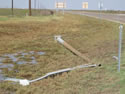
One interesting observation near the intersection of Highways 349 and 176 was that of hail up to the size of quarters, remaining on the ground over nine hours after the last severe storm had passed. Also at that intersection, a 50 foot light pole rated to withstand 80 mph winds, was snapped at the base. All survey observations indicated that the damage was produced by straight line winds.
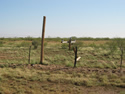
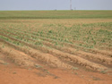
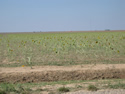
Severe thunderstorms over the western and eastern portions of Dawson County produced large hail and flooding. This resulted in catastrophic damage to cotton, sunflower, and sorghum crops in two separate portions of the county.
Along Farm to Market road 1210, indentations from golf ball to ping pong ball size hail were noted along the sides of the roadway in the muddy areas. Residents in the area noted that it hailed for 20 minutes across this area...while the hail fell for approximately 28 minutes south of Sand in western portions of Dawson County.
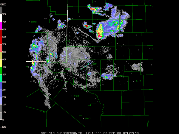
Click on the above image for a radar loop.


PRELIMINARY LOCAL STORM REPORT
NATIONAL WEATHER SERVICE MIDLAND/ODESSA TX
404 AM CDT MON SEP 8 2003

TIME(CDT)  .....CITY LOCATION..... STATE  ...EVENT/REMARKS...
           ....COUNTY LOCATION....

0510 PM    6 E ANDREWS               TX   0.75 INCH HAIL
09/07/03   ANDREWS                        REPORTED ON SH 176
                                          BY PUBLIC.

0605 PM    MIDLAND                   TX   60 MPH TSTM GUST
09/07/03   MIDLAND                        REPORTED IN THE CITY
                                          OF MIDLAND BY OFF DUTY
                                          NWS EMPLOYEE.

0635 PM    MIDLAND                   TX   FLOOD
09/07/03   MIDLAND                        FLOODING AT INTERSECTION
                                          OF LOOP 250 AND FAIRGROUNDS.
                                          CARS STALLED ON ROAD.
                                          REPORTED BY STORM SPOTTER.

0648 PM    5 SE MIDLAND              TX   1.00 INCH HAIL
09/07/03   MIDLAND                        NICKEL TO QUARTER SIZED
                                          HAIL ON SH 158. REPORTED
                                          BY STORM SPOTTER.

0648 PM    5 SE MIDLAND              TX   65 MPH TSTM GUST
09/07/03   MIDLAND                        RECORDED ON SH 158 BY
                                          STORM SPOTTER.

0648 PM    5 SE MIDLAND              TX   1.00 INCH HAIL
09/07/03   MIDLAND                        NICKEL TO QUARTER SIZED
                                          HAIL ON SH 158.

0650 PM    GREENWOOD                 TX   1.00 INCH HAIL
09/07/03   MIDLAND                        REPORTED BY STORM SPOTTER.

0650 PM    GREENWOOD                 TX   FLOOD
09/07/03   MIDLAND                        FLOODING OF CITY STREETS.
                                          REPORTED BY STORM SPOTTER.

0654 PM    3 S  MIDLAND              TX   WIND DAMAGE
09/07/03   MIDLAND                        STORAGE BUILDINGS BLOWN OVER
                                          ON SH 158.

0923 PM    2 E ARVANA                TX   2.75 INCH HAIL
09/07/03   DAWSON                         GOLFBALL TO BASEBALL
                                          SIZED HAIL ALONG FM 2411.
                                          REPORTED BY STORM
                                          SPOTTER.

0925 PM    12 NE LAMESA              TX   1.75 INCH HAIL
09/07/03   DAWSON                         REPORTED BY OFF DUTY NWS
                                          EMPLOYEE.

0930 PM    5 E ARVANA                TX   0.75 INCH HAIL
09/07/03   DAWSON                         PENNY SIZED HAIL COVERING
                                          THE GROUND ON FM 2411.
                                          REPORTED BY STORM SPOTTER.

0945 PM    3 E HANCOCK               TX   1.50 INCH HAIL
09/07/03   DAWSON                         WINDOWS BROKEN BY PING PONG
                                          SIZED HAIL. REPORTED BY
                                          STORM SPOTTER

0950 PM    2 E HANCOCK               TX   1.75 INCH HAIL
09/07/03   DAWSON                         GOLFBALL SIZED HAIL
                                          COVERING THE GROUND.
                                          REPORTED BY STORM SPOTTER.

0955 PM    2 S KEY                   TX   1.75 INCH HAIL
09/07/03   DAWSON                         COTTON CROPS DAMAGED BY
                                          LARGE HAIL ALONG FM 178.
                                          REPORTED BY STORM SPOTTER.

1000 PM    2 N HANCOCK               TX   FLOOD
09/07/03   DAWSON                         WATER COVERING FM 178.
                                          REPORTED BY STORM SPOTTER.

1013 PM    12 NE LAMESA              TX   FLOOD
09/07/03   DAWSON                         CARS STALLED IN WATER
                                          OVER U.S. HWY 87. REPORTED
                                          BY STORM SPOTTER.

1014 PM    3 N KEY                   TX   FLOOD
09/07/03   DAWSON                         5 TO 6 INCHES OF WATER OVER
                                          FM 178 MAKING ROAD
                                          IMPASSABLE. REPORTED BY
                                          STORM SPOTTER.

1200 AM    SAND                      TX   FLOOD
09/08/03   DAWSON                         WATER COVERING U.S. HIGHWAY
                                          180 NEAR SAND. REPORTED BY
                                          LAW ENFORCEMENT OFFICIAL.

0150 AM    15 SW TARZAN              TX   FUNNEL CLOUD
09/08/03   MARTIN                         FUNNEL CLOUD REPORTED 8 MILES
                                          SOUTH OF THE INTERSECTION OF
                                          SH 349 AND SH 176. REPORTED
                                          BY TV METEOROLOGIST AND NWS
                                          EMPLOYEE.

