
Severe thunderstorms are forecast through this weekend along a slow moving cold front and secondary storm system that will impact areas from the southern Plains to the Great Lakes. Large hail and isolated damaging wind gusts are the main threats with these storms along with a risk for heavy to excessive rainfall which could bring flooding. Read More >
A strong upper level storm system combined with an arctic airmass and abundant moisture produced moderate to heavy snows across West Texas and Southeast New Mexico on November 27-28, 2001. The heaviest snows fell in the eastern Permian Basin and in isolated areas near Alpine in northern Brewster county eastward into western Pecos county. A new record daily snowfall was set at the Midland international airport, where 8 inches of snow fell in a 24 hour period. The old record was 6.8 inches of snow which fell in a 24 hour period in January 1974. The record 24 hour snowfall for Midland was 9.8 inches which occurred in December 1998.
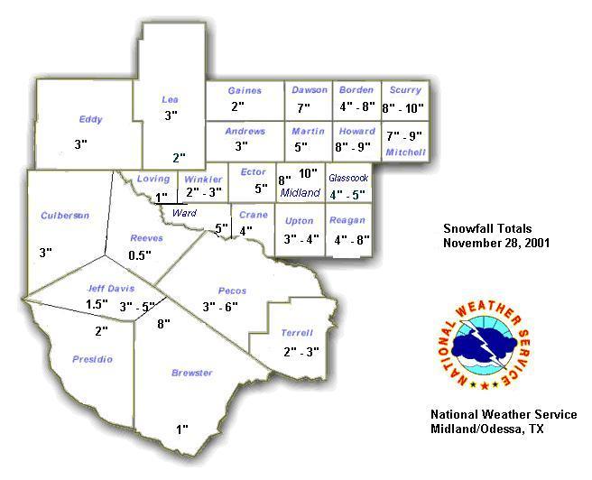
The following plot shows snow totals across the area.
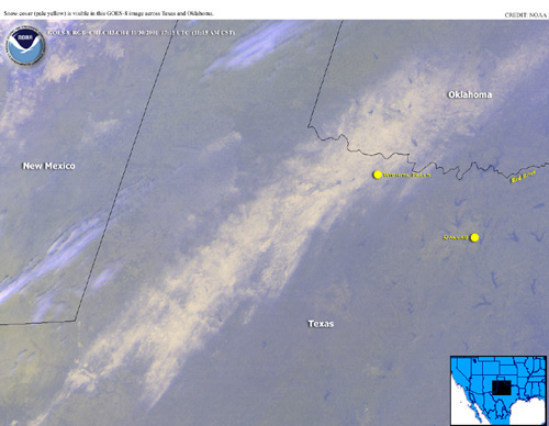
The follow image is a GOES-8 visible satellite depiction of the snowcover following the event.
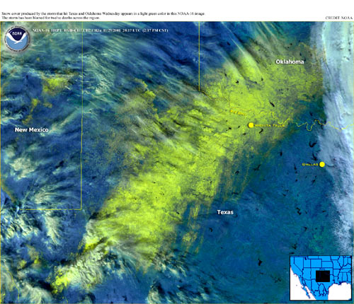
The follow image is a NOAA-16 (polar orbiting) satellite depiction of the snowcover following the event in infrared.
The visible satellite animation below was taken November 29, 2001 from 14:32Z to 20:45Z,one day after a record setting heavy snow storm affected areas from Northern Mexico, East New Mexico, West Texas, and Oklahoma. This shows the extent of the snow coverage from the record setting November snow storm.
Visible satellite animation is an excellent tool for delineating snow coverage. Clouds present in the image, especially high circus clouds do not show up well on visible and normally are in motion. Thus the white pattern that does not move generally could be considered snow cover. But not all of the white pattern is snow. White Sands over south-central New Mexico maintains this appearance year round.
If you look closely, you may notice some landmarks on the satellite image. Some of them have been annotated on the below still image. The heaviest snow occurred from the Davis Mountains, to around Midland/Odessa, to Wichita Falls and into Oklahoma. Amounts within this band ranged from 6-12 inches.
NOUS44 KMAF 291754
PNSMAF

PUBLIC INFORMATION STATEMENT
NATIONAL WEATHER SERVICE MIDLAND/ODESSA TX
1153 AM CST THU NOV 29 2001

...SNOWFALL TOTALS ACROSS WEST TEXAS AND SOUTHEAST NEW MEXICO...

THE FOLLOWING IS A LIST OF SNOWFALL TOTALS ACROSS WEST TEXAS AND
SOUTHEAST NEW MEXICO RECEIVED BY THE NATIONAL WEATHER SERVICE OFFICE
IN MIDLAND FOR NOVEMBER 27-28 2001:

...WEST TEXAS...

LOCATION                        SNOWFALL AMOUNT

ANDREWS COUNTY                  3 INCHES
BORDEN COUNTY (GAIL)            3-4 INCHES
BORDEN COUNTY (EASTERN)         6-8 INCHES
BREWSTER COUNTY (ALPINE)        8 INCHES
BREWSTER COUNTY (BIG BEND PARK) 1 INCH
CRANE COUNTY                    4 INCHES
CULBERSON COUNTY (VAN HORN)     3 INCHES
DAWSON COUNTY (LAMESA)          7 INCHES
ECTOR COUNTY                    5 INCHES
GAINES COUNTY                   2 INCHES
GLASSCOCK COUNTY                4-5 INCHES
HOWARD COUNTY                   8-9 INCHES
JEFF DAVIS COUNTY (FORT DAVIS)  3-5 INCHES
JEFF DAVIS COUNTY (MT. LOCKE)   1.5 INCHES
LOVING COUNTY (MENTONE)         1 INCH
MARTIN COUNTY                   5 INCHES
MIDLAND COUNTY (NWS)            8 INCHES
MIDLAND COUNTY (GREENWOOD)      10 INCHES
MITCHELL COUNTY                 7-9 INCHES
PECOS COUNTY (FORT STOCKTON)    3-6 INCHES
PRESIDIO COUNTY (MARFA)         2 INCHES
REAGAN COUNTY                   4-6 INCHES
REEVES COUNTY (PECOS)           0.5 INCHES
SCURRY COUNTY                   8-10 INCHES
TERRELL COUNTY (SANDERSON)      2-3 INCHES
UPTON COUNTY                    3-4 INCHES
WARD COUNTY (GRAND FALLS)       5 INCHES
WINKLER COUNTY (KERMIT)         2-3 INCHES

...SOUTHEAST NEW MEXICO...

LOCATION                        SNOWFALL AMOUNT

EDDY COUNTY                     3 INCHES
LEA COUNTY (HOBBS)              3 INCHES
LEA COUNTY (JAL)                2 INCHES

THESE TOTALS HAVE BEEN VERIFIED WITH LAW ENFORCEMENT OFFICIALS AND
AREA COOPERATIVE OBSERVERS. THIS LIST WILL BE UPDATED IF ADDITIONAL
REPORTS ARE RECEIVED.

$$

CLL

