
Life-threatening, potentially catastrophic flash flooding expected along the central Gulf Coast as the remnants of Arthur track across the area. Isolated brief tornadoes and damaging gusts remain possible overnight in the Southeast. Isolated to scattered dry thunderstorms may cause lightning-ignited fires and erratic behavior due to gusty winds across parts of the West Friday. Read More >
Midland/Odessa
Weather Forecast Office
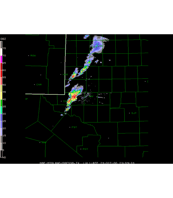
The radar animation below is from the October 24, 2000, severe weather event. It produced tornadic thunderstorms and flash flooding across the central Permian Basin. The sequence of images were taken approximately 5 minutes apart, from 6:00 PM CDT to 10:04 PM CDT.
The many hook shaped echoes that occurred frequently with this event; prompted the issuance of numerous severe thunderstorm and tornado warnings that evening. This severe weather event affected the most populated regions of the Permian Basin; the cities of Odessa and Midland. Very heavy rains from those thunderstorms produced flash flooding too.
Hazards
Spotter Briefing
Outlook
Current Hazards
Storm Report
Severe Weather
Drought
Storm Prediction Center
Weather Prediction Center
National Hurricane Center
Active Alerts
Winter Weather
Past Weather
Cooperative Observations
Local Climate Data
National Climate
Current Weather
Observations
Satellite
Upper Air
West Texas Mesonet
Radar
Forecasts
Activity Planner
Aviation
Climate Prediction Center
Fire
Forecast Discussion
Graphical
Local
Space Weather Center
Information Center
Weather Trivia
Forecast Models
GIS
International Weather
Glossary
Road Conditions
Water
Hydrology
Precipitation Estimates
Quantitative Precipitation Forecasts
US Dept of Commerce
National Oceanic and Atmospheric Administration
National Weather Service
Midland/Odessa
2500 Challenger Dr.
Midland, TX 79706-2606
(432) 563-5006
Comments? Questions? Please Contact Us.

