
Severe thunderstorms are forecast through this weekend along a slow moving cold front and secondary storm system that will impact areas from the southern Plains to the Great Lakes. Large hail and isolated damaging wind gusts are the main threats with these storms along with a risk for heavy to excessive rainfall which could bring flooding. Read More >
Severe weather and flooding affected the West Texas and Southeast New Mexico region. This was an early outbreak of severe weather over our forecast and warning area. Below are some images and links to some of the storm data that occurred with this event.
A number of tornadoes were generated during both events. One tornado that struck the community of Wickett (Ward County) was rated an F0. This tornado did some damage in town. Hail to golfball in size was reported with some of the severe thunderstorms March 21 and early March 22nd. Those storms affected an area from north of Pecos (Reeves County) and Mentone (Loving County), to north of Hobbs (Lea County), Seminole (Gaines County), and Lamesa (Dawson County). Rainfall amounts those storms upwards of 2.56" was measured in Seminole (Gaines County), with radar estimates of over 5" east of Seminole. See the rainfall image for March 21-22nd.
March 22 - 23...
This severe storm and flooding event was even busier. This event started during the early afternoon with a severe thunderstorm warning forUpton County. Many of those thunderstorms were obviously of the supercell variety (per our radar and spotter reports), producing an assortment of severe weather. A few tornado touchdowns were noted from this event, with some damage reported in Upton, Glasscock, and Reagan counties. See the Reagan/Glasscock Damage Report below. We also received numerous reports of large hail and damaging winds associated with those severe thunderstorms.
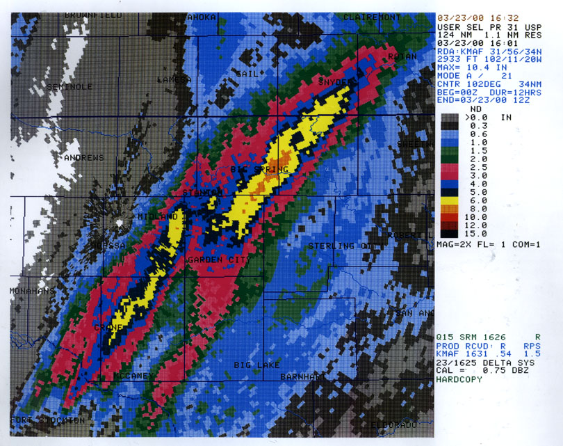
Those storms exhibited a train echoing characteristic (forming and moving over the same location). This produced widespread flooding and flash flooding, covering an area roughly 20 miles either side of a line from north of Bakersfield (Pecos County) to Greenwood (Midland County), to east of Garden City (Glasscock County), to Big Spring (Howard County), and Snyder (Scurry County). Rivers and streams over our eastern and southeastern areas quickly rose to flood stage. Many roads over this area were closed the evening of March 22nd and remained closed through the morning hours.
The most damaging of a series of tornadoes to touch down during the evening of Wednesday, March 22, 2000 was surveyed the next afternoon. Based on eyewitness accounts, weather office telephone logs and radar information, we believe the public initially spotted a tornado around 10:35 PM north of Texon near Stiles along FM 1357 in northern Reagan County.
The initial warning for this tornado was disseminated at 10:17 PM, effective until 11:00 PM, based on weather radar information at 10:14 PM. This tornado continued moving northeast and did telephone pole damage to a major transformer location along of FM 1357 and between Highway 137 and FM 3093. The tornado then crossed FM 1357 and did damage to a wood frame house located 300 yard north of FM 1357, resulting in minor injuries to two adults and a one-year old infant child located inside the house at around 10:45 PM.
A review of the damage of this wood frame house indicated that the house was lifted off its foundation and placed 20 feet northeast of its original location. Two of the four walls were completed blown off the house and the house was found rotated 90 degrees, such that the south facing front door was now facing east. A pickup truck was lifted and found overturned in the yard and two other cars was found heavily damaged after being moved over 100 feet. The roof was completely removed and could not be subsequently found. Damage was estimated to be F-3 on the Fujita Tornado Intensity Scale or 158 to 206 mph winds.
The tornado continued northeast about 5 miles crossing FM 3093 north of FM1357 and completed demolished a storage shed and barn around 11:05 PM. This tornado then continued northeast another mile stuck a trailer home located between FM 3093 and County Road 105 in extreme northern Reagan county. Two adults in the trailer home suffered injuries and were admitted to the Reagan County hospital in Big Lake. The trailer home was tied down with cables connecting the trailer home to two 5 inches diameter pipes submerged in two inches of concrete. The trailer home was found completely destroyed with its frame lifted and then deposited 50 feet northeast of its original location, tie down cables completely severed. Debris was scattered hundreds of yards in all directions. Damage was estimated to be F-2 on the Fujita Tornado Intensity Scale.
The tornado continued northeast, north of FM 3093 for another three miles, reaching a well-built brick house located along the west side of County Road 105 about two miles south of FM 2401, or about two miles southeast of St. Lawrence in extreme southern Glasscock County around 11:15 PM. A tornado warning for Glasscock County was disseminated at 11:10 PM, effective until midnight. The brick house suffered extensive roof damage, with two roof beams breaking off and entering the living area of the house. Six large trees located on the southern side of the house were completely uprooted and facing different directions. Debris was scattered hundreds of yards. Damage was estimated to be F-2 based on the fact that the roof was damaged but not removed and all the brick walls survived the tornadic winds.
The tornado then continued northeast, crossing FM 2401 four miles east of St. Lawrence in southern Glasscock County. A barn was completely demolished and several utility poles were destroyed. The debris from the barn and utility poles were found facing different directions and debris scattered hundreds of yards. Damage was estimated at F-2.
The tornado then continued northeast another mile and stuck several utility poles, completely severing the utility poles along FM 33 about one mile north of FM 2401 near County Road 170.
The resultant tornado track across Reagan and Glasscock Counties was about 100 yards wide and 14 miles long.

REGIONAL TEMPERATURE AND PRECIPITATION TABLE
NATIONAL WEATHER SERVICE MIDLAND TX
1147 AM CST (1047 AM MST) WED MAR 22 2000

LOW TEMPERATURE THIS MORNING
HIGH TEMPERATURE YESTERDAY
24 HOUR PRECIPITATION

.B MAF 0322 DH17/TN/TX/PP
:
:ID     STATION                  LOW    HIGH    PRECIP
:---TEXAS-----------------------------------------------
ALPT2 : ALPINE                :   41  /   80  /  0.00  /
BART2 : BAKERSFIELD           :   58  /   86  /  0.00  /
BILT2 : BIG LAKE DCP          :    +  /    +  /  0.00  /
BIST2 : BIG SPRING            :   56  /   83  /  0.03  /
BOQT2 : BOQUILLAS             :   51  /   95  /  0.00  /
CDET2 : CANDELARIA            :    +  /   87  /   +    /
CSLT2 : CASTOLON              :   52  /   94  /  0.00  /
BBPT2 : CHISOS BASIN          :   50  /   76  /  0.00  /
CDCT2 : COLORADO CITY         :   55  /   84  /  0.00  /
BCPT2 : COPE RANCH            :    +  /    +  /  0.00  /
DYNT2 : DRYDEN 16S            :    +  /    +  /  0.00  /
FDVT2 : FORT DAVIS            :    +  /   79  /   +    /
AGST2 : FORT STOCKTON         :   47  /   84  /  0.00  /
FST   : FORT STOCKTON ARPT    :   55  /   86  /  0.00  /
GAAT2 : GAIL                  :    +  /   81  /   +    /
GDP   : GUADALUPE PASS        :   47  /   73  /  0.00  /
HECT2 : HEATH CANYON          :   66  /   94  /  0.00  /
TELT2 : JOHNSON RANCH         :    +  /    +  /  0.00  /
KENT2 : KENT 8SE              :   40  /   72  /  0.00  /
TGAT2 : LAJITAS               :    +  /   93  /   +    /
LAST2 : LAMESA                :   48  /   78  /  0.83  /
MRNT2 : MARATHON              :   39  /   81  /  0.00  /
MRF   : MARFA AIRPORT         :   37  /   77  /   +    /
MCCT2 : MCCAMEY               :    +  /   87  /  0.00  /
MAF   : MIDLAND               :   57  /   79  /  0.00  /
FDIT2 : MOUNT LOCKE           :   44  /   75  /  0.00  /
ODET2 : ODESSA                :   53  /   83  /  0.00  /
ODO   : ODESSA SCHLEMEYER     :   57  /   80  /  0.00  /
PAJT2 : PANTHER JUNCTION      :   56  /   84  /  0.00  /
PEOT2 : PECOS 8W              :   48  /   83  /  0.06  /
PNWT2 : PENWELL               :   56  /   84  /  0.10  /
PNGT2 : PERSIMMON GAP         :   55  /   89  /  0.00  /
RLAT2 : RED BLUFF DAM         :    +  /   81  /   +    /
SEMT2 : SEMINOLE              :   48  /   76  /  2.56  /
SHFT2 : SHEFFIELD             :    +  /   86  /   +    /
SICT2 : SHEFFIELD 17SE        :    +  /    +  /  0.00  /
STST2 : STILES                :    +  /    +  /  0.00  /
STGT2 : TERLINGUA RANCH       :   49  /   84  /   +    /
6R6   : TERRELL CO AIRPORT    :    +  /    +  /  0.00  /
VALT2 : VALENTINE             :    +  /   78  /   +    /
INK   : WINKLER CO AIRPORT    :   54  /   83  /  0.00  /
:---NEW MEXICO------------------------------------------
ATS   : ARTESIA *             :   42  /   60  /   +    /
ATSN5 : ARTESIA 4E            :    +  /    +  /  0.00  /
ARTN5 : ARTESIA 6S            :   42  /   63  /  0.08  /
CNM   : CARLSBAD AIRPORT      :    +  /   82  /   +    /
CNM   : CARLSBAD ASOS         :   44  /   82  /  0.03  /
CRLN5 : CARLSBAD CAVERNS      :   39  /   64  /  0.01  /
HOPN5 : HOPE                  :   39  /   56  /  0.50  /
JALN5 : JAL                   :    +  /   80  /   +    /
TATN5 : TATUM                 :   38  /   58  /  0.98  /
:
: + - DENOTES MISSING OR UNREPORTED DATA
: * - TEMPERATURES ESTIMATED FROM HOURLY OBSERVATIONS
:
: ASOS - AUTOMATED SURFACE OBSERVING SYSTEM
: DCP  - DATA COLLECTION PLATFORM
: RAWS - REMOTE AUTOMATIC WEATHER STATION. VALUES MAY BE ESTIMATED.
:
.END
REGIONAL TEMPERATURE AND PRECIPITATION TABLE
NATIONAL WEATHER SERVICE MIDLAND TX
1202 PM CST (1102 AM MST) THU MAR 23 2000

LOW TEMPERATURE THIS MORNING
HIGH TEMPERATURE YESTERDAY
24 HOUR PRECIPITATION

.B MAF 0323 DH17/TN/TX/PP
:
:ID     STATION                  LOW    HIGH    PRECIP
:---TEXAS-----------------------------------------------
ACKT2 : ACKERLY 4SE           :    +  /    +  /  2.60  /
ALPT2 : ALPINE                :   39  /   80  /  0.00  /
BART2 : BAKERSFIELD           :   48  /   70  /  0.55  /
BILT2 : BIG LAKE DCP          :    +  /    +  /  0.75  /
BIST2 : BIG SPRING            :   47  /   64  /  4.20  /
BGGT2 : BIG SPRING 5NE        :    +  /    +  /  3.53  /
BOQT2 : BOQUILLAS             :   52  /   98  /  0.00  /
CDET2 : CANDELARIA            :    +  /   86  /   +    /
CSLT2 : CASTOLON              :   54  /   98  /  0.00  /
BBPT2 : CHISOS BASIN          :   41  /   80  /  0.00  /
CDCT2 : COLORADO CITY         :   47  /   74  /   +    /
BCPT2 : COPE RANCH            :    +  /    +  /  1.26  /
CRAT2 : CRANE                 :    +  /    +  /  2.55  /
DOGT2 : DOG CANYON            :   22  /   69  /  0.01  /
DYNT2 : DRYDEN 16S            :    +  /    +  /  0.00  /
FRNT2 : FORSAN                :    +  /    +  /  5.33  /
FDVT2 : FORT DAVIS            :    +  /   79  /   +    /
AGST2 : FORT STOCKTON         :   45  /   74  /  0.05  /
FST   : FORT STOCKTON ARPT    :   45  /   75  /   +    /
GAAT2 : GAIL                  :    +  /   71  /   +    /
GGAT2 : GAIL                  :    +  /    +  /  2.00  /
GDP   : GUADALUPE PASS        :   34  /   60  /  0.00  /
TELT2 : JOHNSON RANCH         :    +  /    +  /  0.00  /
KENT2 : KENT 8SE              :   37  /   62  /  0.00  /
KNPT2 : KNAPP 2SW             :    +  /    +  /  4.18  /
TGAT2 : LAJITAS               :    +  /   94  /   +    /
LAST2 : LAMESA                :   41  /   54  /  0.43  /
MRF   : MARFA AIRPORT         :   30  /   75  /   +    /
MCCT2 : MCCAMEY               :    +  /   75  /  1.98  /
MAF   : MIDLAND               :   44  /   69  /  0.33  /
YEAT2 : MIDLAND BEDFORD       :    +  /    +  /  1.28  /
MDIT2 : MIDLAND 21SE          :    +  /    +  /  5.00  /
FDIT2 : MOUNT LOCKE           :   32  /   72  /  0.00  /
ODET2 : ODESSA                :    +  /   65  /  0.20  /
ODO   : ODESSA SCHLEMEYER     :   46  /   69  /   +    /
PAJT2 : PANTHER JUNCTION      :   49  /   87  /  0.00  /
PEOT2 : PECOS 8W              :   49  /   68  /  0.01  /
PNWT2 : PENWELL               :   43  /   72  /  0.02  /
PNGT2 : PERSIMMON GAP         :   49  /   93  /  0.00  /
PSGT2 : PINE SPRINGS          :   38  /   60  /  0.00  /
PRST2 : PRESIDIO              :    +  /   89  /   +    /
RKNT2 : RANKIN 15NW           :    +  /    +  /  1.75  /
RLAT2 : RED BLUFF DAM         :    +  /   67  /   +    /
SEMT2 : SEMINOLE              :   41  /   53  /  0.03  /
SHFT2 : SHEFFIELD             :    +  /   84  /   +    /
SICT2 : SHEFFIELD 17SE        :    +  /    +  /  0.00  /
SNYT2 : SNYDER                :   46  /   62  /  5.25  /
STST2 : STILES                :    +  /    +  /  1.09  /
STGT2 : TERLINGUA RANCH       :   46  /   88  /   +    /
6R6   : TERRELL CO AIRPORT    :   51  /   84  /  0.00  /
VALT2 : VALENTINE             :    +  /   76  /   +    /
INK   : WINKLER CO AIRPORT    :   42  /   69  /  0.09  /
:---NEW MEXICO------------------------------------------
ATS   : ARTESIA *             :   39  /   55  /   +    /
ATSN5 : ARTESIA 4E            :    +  /    +  /  0.00  /
ARTN5 : ARTESIA 6S            :   37  /   54  /  0.07  /
CNM   : CARLSBAD AIRPORT      :   39  /   54  /   +
CNM   : CARLSBAD ASOS         :    +  /    +  /  0.00  /
HOB   : HOBBS AIRPORT         :   39  /   54  /   +    /
HOPN5 : HOPE                  :   38  /   49  /  0.30  /
:
: + - DENOTES MISSING OR UNREPORTED DATA
: * - TEMPERATURES ESTIMATED FROM HOURLY OBSERVATIONS
:
: ASOS - AUTOMATED SURFACE OBSERVING SYSTEM
: DCP  - DATA COLLECTION PLATFORM
: RAWS - REMOTE AUTOMATIC WEATHER STATION. VALUES MAY BE ESTIMATED.
:
.END
PRELIMINARY LOCAL STORM REPORT
NATIONAL WEATHER SERVICE MIDLAND TX
730 AM CST THU MAR 23 2000
TIME(CDT) .....CITY LOCATION.....STATE ...EVENT/REMARKS...
....COUNTY LOCATION....
252 PM 8 NW RANKIN TX FUNNEL CLOUD
03/22/00 UPTON REPORTED BY LOCAL LAW
ENFORCEMENT.
304 PM 5 N RANKIN TX TORNADO
03/22/00 UPTON REPORTED BY LOCAL LAW
ENFORCEMENT.
410 PM 10 SW MIDKIFF TX 3 INCH HAIL
03/22/00 UPTON REPORTED AT FM 2401 AND TX
349 BY PUBLIC.
410 PM 10 SW MIDKIFF TX 1.75 INCH HAIL
03/22/00 UPTON GOLFBALL HAIL COVERING ROAD
AT FM 2401 AND TX 349.
REPORTED BY PUBLIC.
420 PM 20 NW FORT STOCKTON TX 1.75 INCH HAIL
03/22/00 PECOS GOLFBALL HAIL IN GIRVIN.
REPORTED BY LOCAL LAW
ENFORCEMENT.
450 PM 10 SSE GARDEN CITY TX FUNNEL CLOUD
03/22/00 GLASSCOCK REPORTED BY PUBLIC.
455 PM 10 NE RANKIN TX TORNADO
03/22/00 UPTON REPORTED BY LOCAL LAW
ENFORCEMENT.
550 PM 12 SE BIG SPRING TX TORNADO
03/22/00 HOWARD PUBLIC REPORTED TORNADO.
556 PM 10 E MIDLAND TX FLASH FLOODING
03/22/00 MIDLAND TX 158 UNDER WATER.
REPORTED BY AMATEUR RADIO
SPOTTERS.
615 PM 4 SW GARDEN CITY TX FUNNEL CLOUD
03/22/00 GLASSCOCK REPORTED BY SPOTTER.
620 PM 2 N RANKIN TX FUNNEL CLOUD
03/22/00 UPTON REPORTED BY SPOTTER.
630 PM GARDEN CITY TX 1.75 INCH HAIL
03/22/00 GLASSCOCK GOLFBALL HAIL REPORTED BY
SPOTTER ON THE WEST SIDE
OF GARDEN CITY.
630 PM 4 S WESTBROOK TX TORNADO
03/22/00 MITCHELL REPORTED BY DPS.
640 PM 10 SW MIDKIFF TX TORNADO
03/22/00 UPTON FUNNEL AND DEBRIS CLOUD ON
GROUND NEAR FM 2401 AND TX
349. REPORTED BY AMATEUR
RADIO SPOTTER.
657 PM 10 S SNYDER TX 1 INCH HAIL
03/22/00 SCURRY REPORTED BY LOCAL LAW
ENFORCEMENT.
705 PM CRANE TX FLASH FLOODING
03/22/00 CRANE STREET FLOODING REPORTED
BY LOCAL LAW ENFORCEMENT.
715 PM 14 NW GARDEN CITY TX TORNADO
03/22/00 GLASSCOCK TORNADO CROSSED US 87 2
MILES WEST OF GLASSCOCK/
STERLING COUNTY LINE.
715 PM 14 NW GARDEN CITY TX 2 INCH HAIL
03/22/00 GLASSCOCK LARGE HAIL KNOCKED WINDOWS
OUT OF CARS.
720 PM CRANE TX 1.75 INCH HAIL
03/22/00 CRANE REPORTED BY LOCAL LAW
ENFORCEMENT.
720 PM CRANE TX FLASH FLOODING
03/22/00 CRANE SEVERAL STREETS IN CRANE
UNDERWATER. REPORTED BY
LOCAL LAW ENFORCEMENT.
724 PM 15 N GARDEN CITY TX FLASH FLOODING
03/22/00 GLASSCOCK 1 FOOT OF WATER OVER FM 461
EAST OF TX 33. REPORTED
BY SKYWARN SPOTTERS.
735 PM 16 S GARDEN CITY TX FUNNEL CLOUDS
03/22/00 GLASSCOCK REPORTED BY LOCAL LAW
ENFORCEMENT.
735 PM 16 W GARDEN CITY TX 1.75 INCH HAIL
03/22/00 GLASSCOCK REPORTED BY LOCAL LAW
ENFORCEMENT.
740 PM 5 SW COLORADO CITY TX 1.75 INCH HAIL
03/22/00 MITCHELL REPORTED BY RADIO STATION.
740 PM 13 SW GARDEN CITY TX TORNADO
03/22/00 GLASSCOCK TORNADO REPORTED NEAR FM
2401 BY LOCAL LAW
ENFORCEMENT.
800 PM 16 W GARDEN CITY TX FLASH FLOODING
03/22/00 GLASSCOCK 2 FEET OF WATER COVERING
INTERSECTION OF TX 137 AND
TX 158. REPORTED BY LOCAL
LAW ENFORCEMENT.
810 PM 10 S BIG SPRING TX 1.75 INCH HAIL
03/22/00 HOWARD GOLFBALL HAIL REPORTED AT
THE INTERSECTION OF US 87
AND FM 461.
815 PM 8 W CRANE TX 1.00 INCH HAIL
03/22/00 CRANE REPORTED BY LOCAL LAW
ENFORCEMENT.
836 PM 13 SW MIDLAND TX FLASH FLOODING
03/22/00 MIDLAND WATER COVERING FM 1788 7
MILES SOUTH OF I-20.
REPORTED BY SPOTTER.
910 PM MIDKIFF TX FLASH FLOODING
03/22/00 UPTON REPORTED BY TX DOT.
925 PM 4 N MCCAMEY TX 1.75 INCH HAIL
03/22/00 UPTON GOLFBALL HAIL REPORTED BY
LOCAL LAW ENFORCEMENT.
950 PM 10 N MCCAMEY TX FLASH FLOODING
03/22/00 UPTON 3 INCHES OF WATER OVER US
385 NORTH OF MCCAMEY.
REPORTED BY LOCAL LAW
ENFORCEMENT.
1035 PM 8 N GARDEN CITY TX TORNADO
03/22/00 GLASSCOCK SPOTTERS REPORTED TWO
TORNADOES.
1040 PM TEXON TX TORNADO
03/22/00 REAGAN PUBLIC REPORTED TORNADO
NEAR TEXON AND RELAYED
REPORT TO LOCAL LAW
ENFORCEMENT.
1045 PM 10 NE STILES TX TORNADO
03/22/00 REAGAN TORNADO DESTROYED STORAGE
BUILDING. REPORTED BY
LOCAL LAW ENFORCEMENT.
1045 PM 19 N BIG LAKE TX TORNADO
03/22/00 REAGAN *** 3 INJ ***
TORNADO DESTROYED AT LEAST
2 HOMES CLOSE TO FM 33.
REPORTED BY LOCAL LAW
ENFORCEMENT.
1048 PM 10 S CRANE TX FLASH FLOODING
03/22/00 CRANE US 385 BETWEEN CRANE AND
MCCAMEY UNDER WATER.
REPORTED BY SKYWARN
SPOTTERS.
1048 PM 8 E CRANE TX FLASH FLOODING
03/22/00 CRANE TX 329 BARRICADED EAST OF
CRANE. REPORTED BY SKYWARN
SPOTTERS.
1127 PM 10 S BIG SPRING TX FLASH FLOODING
03/22/00 HOWARD FM 33 SOUTH OF BIG SPRING
FLOODED.
1127 PM 10 S MIDLAND TX FLASH FLOODING
03/22/00 MIDLAND NUMEROUS ROADS IMPASSABLE
FROM HIGH WATER. REPORTED
BY SKYWARN SPOTTERS.
1133 PM 2 SE MIDLAND TX FLASH FLOODING
03/22/00 MIDLAND TX 349 AND TX 158 CLOSED
FROM HIGH WATER. REPORTED
BY SKYWARN SPOTTERS.
1133 PM GREENWOOD TX FLASH FLOODING
03/22/00 MIDLAND FM 307 AND FM 1379 UNDER
WATER. REPORTED BY SKYWARN
SPOTTERS.
1133 PM 13 SE SPRABERRY TX FLASH FLOODING
03/22/00 MIDLAND FM 1357 AND FM 1160 UNDER
WATER. REPORTED BY SKYWARN
SPOTTERS.
1140 PM 18 SW GARDEN CITY TX 0.75 INCH HAIL
03/22/00 GLASSCOCK REPORTED 10 MILES SOUTH OF
THE INTERSECTION OF TX 137
AND TX 158 BY LOCAL LAW
ENFORCEMENT.
1206 AM COUNTYWIDE TX FLASH FLOODING
03/23/00 CRANE US 385 SOUTH TO MCCAMEY
CLOSED FROM HIGH WATER.
ALSO TX 329 EAST TO RANKIN
CLOSED FROM HIGH WATER.
REPORTED BY LOCAL LAW
ENFORCEMENT.
1206 AM 7 E SPRABERRY TX FLASH FLOODING
03/23/00 MIDLAND 2.5 FEET OF WATER COVERING
INTERSECTION OF TX 137 AND
TX 158. REPORTED BY LOCAL
LAW ENFORCEMENT.
1256 AM 10 N RANKIN TX FLASH FLOODING
03/23/00 UPTON TX 349 IMPASSABLE FROM HIGH
WATER.
120 AM GARDEN CITY TX FLASH FLOODING
03/23/00 MIDLAND TX 158 CLOSED FROM GARDEN
CITY TO MIDLAND COUNTY LINE
BY HIGH WATER. REPORTED BY
LOCAL LAW ENFORCEMENT.

