National Weather Service United States Department of Commerce

Here is a local radar view.
There will be some increased potential for strong to severe thunderstorms on Tuesday afternoon and evening, mainly over the northwest half of the state. Large hail, damaging winds, and a tornado or two is possible.
There will be some increased potential for strong to severe thunderstorms on Wednesday into Wednesday night. The primary threats will be damaging wind gusts and large hail. Also, a tornado or two can not be ruled out.
Shown in the graphic on left, excessive rainfall outlook for Tuesday/Tuesday night. The graphic on right, excessive rainfall outlook for Wednesday/Wednesday night. A moderate risk of rainfall exceeding flash flood guidance is possible over western Arkansas on Wednesday into Wednesday night.
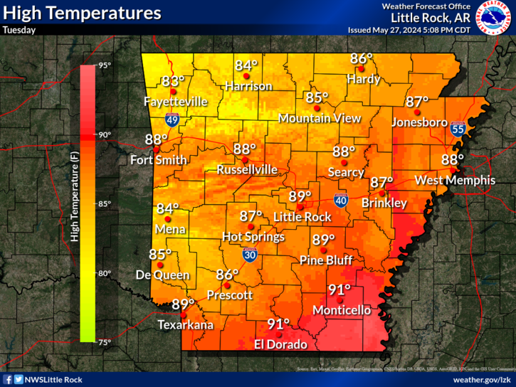
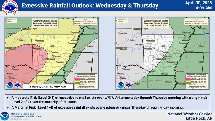
Rainfall is expected Tuesday through Thursday across much of the state as the next weather system brings the chance for severe weather Tuesday and Wednesday in addition to heavy rainfall. Generally, 1-3" of total rainfall is expected over west and northwest Arkansas with locally higher amounts possible. Further south and east, these total amounts are expected to decrease to 0.5-1".

 
Hourly Weather Roundup ( )
Location Sky/Weather Temp Dewpt RH Wind Baro Remarks
Fayetteville
N/A
N/A
N/A
N/A
N/A
N/A
N/A
Harrison
N/A
N/A
N/A
N/A
N/A
N/A
N/A
Mountain Home
N/A
N/A
N/A
N/A
N/A
N/A
N/A
Jonesboro
N/A
N/A
N/A
N/A
N/A
N/A
N/A
Fort Smith
N/A
N/A
N/A
N/A
N/A
N/A
N/A
Russellville
N/A
N/A
N/A
N/A
N/A
N/A
N/A
Mount Ida
N/A
N/A
N/A
N/A
N/A
N/A
N/A
Hot Springs
N/A
N/A
N/A
N/A
N/A
N/A
N/A
Little Rock
N/A
N/A
N/A
N/A
N/A
N/A
N/A
North Little Rock
N/A
N/A
N/A
N/A
N/A
N/A
N/A
West Memphis
N/A
N/A
N/A
N/A
N/A
N/A
N/A
Texarkana
N/A
N/A
N/A
N/A
N/A
N/A
N/A
El Dorado
N/A
N/A
N/A
N/A
N/A
N/A
N/A
Pine Bluff
N/A
N/A
N/A
N/A
N/A
N/A
N/A
Monticello
N/A
N/A
N/A
N/A
N/A
N/A
N/A
Note: "N/A" or "MISG" will be displayed if values are not available. In the LOCATION column, click on links for a list of recent observations at sites of interest. In the WIND column, VRB is "variable" and G is "gust". Wind speeds are in MPH. In the BARO (pressure) column, values are in inches. In the REMARKS column, HX is "heat index", WCI is "wind chill index", and VSB is "visibility" (if shown).
 
 
Point Forecasts
Cities in Arkansas Coordinates (make sure "Lon" is negative)
Lat:   Lon:
 
Local Hazards
Local Hazards
Decision Support
Decision Support
Submit Storm Report
Submit Storm Report
Local Forecast Page
Local Forecast Page
Radar Links
Radar Links
Local Climate Page
Local Climate Page
Local Observations Page
Local Satellite Page
Local Drought Page
Local Drought Page
Local Hydrology Page
Local Fire Page
Local Fire Page
Text Product Viewer
Text Product Viewer