National Weather Service United States Department of Commerce
Click a location below for detailed forecast.

Last Map Update: Thu, Sep 26, 2024 at 5:20:32 pm CDT

Here is a regional radar view.
A storm system ("L") in or near Arkansas will be stuck between areas of high pressure ("H") over the southern Rockies and just off the mid-Atlantic Coast. Moisture from the remnants of tropical system Helene will get pulled toward the system, with heavy rain possible in northeast sections of the state.
Heavy to excessive (flooding) rain is expected from the Florida Gulf Coast to the Tennessee Valley and southern Appalachians. Some areas could receive more than a foot of precipitation. Farther west, the forecast calls for two to three inches of rain in northeast Arkansas.
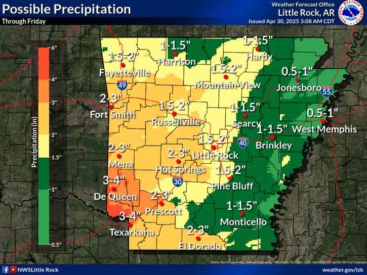
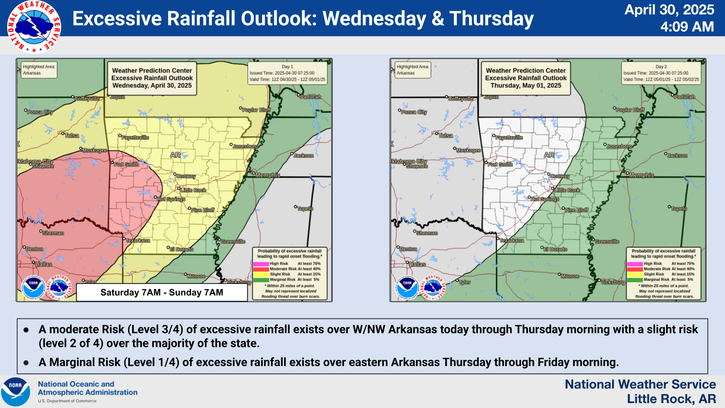
The heaviest rain will be over northeast Arkansas where to to three inch amounts are expected. Farther west toward Little Rock, half inch to inch totals are in the forecast. A tenth of an inch of rain or less will occur over far western and southern sections of thethe forecast calls for two to three inches of rain in northeast Arkansas.
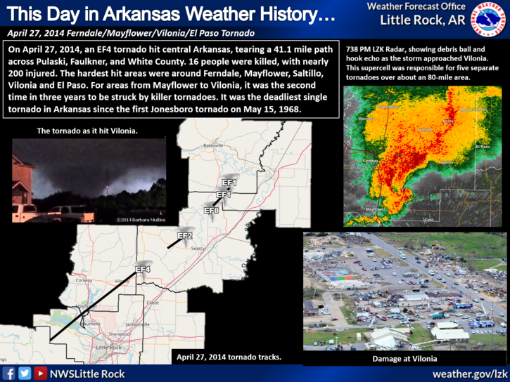
A breezy northwest wind will be noted on Friday, with maximum gusts from 20 to 30 mph in northern and eastern Arkansas.
Risks of destructive wind, severe weather/tornadoes, and catastrophic flooding will be well to the east of Arkansas during this event. However, there is a slight risk of flash flooding in northeast sections of the state.

 
Hourly Weather Roundup ( )
Location Sky/Weather Temp Dewpt RH Wind Baro Remarks
Fayetteville
N/A
N/A
N/A
N/A
N/A
N/A
N/A
Harrison
N/A
N/A
N/A
N/A
N/A
N/A
N/A
Mountain Home
N/A
N/A
N/A
N/A
N/A
N/A
N/A
Jonesboro
N/A
N/A
N/A
N/A
N/A
N/A
N/A
Fort Smith
N/A
N/A
N/A
N/A
N/A
N/A
N/A
Russellville
N/A
N/A
N/A
N/A
N/A
N/A
N/A
Mount Ida
N/A
N/A
N/A
N/A
N/A
N/A
N/A
Hot Springs
N/A
N/A
N/A
N/A
N/A
N/A
N/A
Little Rock
N/A
N/A
N/A
N/A
N/A
N/A
N/A
North Little Rock
N/A
N/A
N/A
N/A
N/A
N/A
N/A
West Memphis
N/A
N/A
N/A
N/A
N/A
N/A
N/A
Texarkana
N/A
N/A
N/A
N/A
N/A
N/A
N/A
El Dorado
N/A
N/A
N/A
N/A
N/A
N/A
N/A
Pine Bluff
N/A
N/A
N/A
N/A
N/A
N/A
N/A
Monticello
N/A
N/A
N/A
N/A
N/A
N/A
N/A
Note: "N/A" or "MISG" will be displayed if values are not available. In the LOCATION column, click on links for a list of recent observations at sites of interest. In the WIND column, VRB is "variable" and G is "gust". Wind speeds are in MPH. In the BARO (pressure) column, values are in inches. In the REMARKS column, HX is "heat index", WCI is "wind chill index", and VSB is "visibility" (if shown).
 
 
Point Forecasts
Cities in Arkansas Coordinates (make sure "Lon" is negative)
Lat:   Lon:
 
Local Hazards
Local Hazards
Decision Support
Decision Support
Submit Storm Report
Submit Storm Report
Local Forecast Page
Local Forecast Page
Radar Links
Radar Links
Local Climate Page
Local Climate Page
Local Observations Page
Local Satellite Page
Local Drought Page
Local Drought Page
Local Hydrology Page
Local Fire Page
Local Fire Page
Text Product Viewer
Text Product Viewer