Read the Hazardous Weather Outlook (click to read)
372 FLUS43 KJKL 300212 HWOJKL Hazardous Weather Outlook National Weather Service Jackson KY 1012 PM EDT Tue Apr 29 2025 KYZ079-080-083>088-107-109-110-112>120-301100- Pulaski-Laurel-Wayne-McCreary-Whitley-Knox-Bell-Harlan-Johnson- Magoffin-Floyd-Breathitt-Knott-Owsley-Perry-Clay-Leslie-Letcher- Martin-Pike- 1012 PM EDT Tue Apr 29 2025 ...SEVERE THUNDERSTORM WATCH 193 IN EFFECT UNTIL 1 AM EDT WEDNESDAY... This Hazardous Weather Outlook is for a portion of eastern Kentucky. .DAY ONE...Tonight. Thunderstorms are possible at times into tonight. Some of the thunderstorms may be severe, especially during the evening hours. Damaging winds are the primary threat. However, isolated large hail can`t be ruled out. .DAYS TWO THROUGH SEVEN...Wednesday through Monday. Thunderstorms are possible at times from Wednesday into Saturday. Some of the thunderstorms Thursday could be strong, with gusty winds being the primary threat. .SPOTTER INFORMATION STATEMENT... Spotters are requested to report any occurrences of damaging wind or hail tonight. $$ KYZ068-069-108-111-301100- Rockcastle-Jackson-Wolfe-Lee- 1012 PM EDT Tue Apr 29 2025 This Hazardous Weather Outlook is for a portion of eastern Kentucky. .DAY ONE...Tonight. Thunderstorms are possible. .DAYS TWO THROUGH SEVEN...Wednesday through Monday. Thunderstorms are possible at times from Wednesday into Saturday. Some of the thunderstorms Thursday could be strong, with gusty winds being the primary threat. .SPOTTER INFORMATION STATEMENT... Spotter activation is not anticipated. $$ KYZ044-050>052-058>060-104-106-301100- Fleming-Montgomery-Bath-Rowan-Estill-Powell-Menifee-Elliott-Morgan- 1012 PM EDT Tue Apr 29 2025 This Hazardous Weather Outlook is for a portion of eastern Kentucky. .DAY ONE...Tonight. No hazardous weather is expected at this time. .DAYS TWO THROUGH SEVEN...Wednesday through Monday. Thunderstorms are possible at times from Wednesday into Saturday. Some of the thunderstorms Thursday could be strong, with gusty winds being the primary threat. .SPOTTER INFORMATION STATEMENT... Spotter activation is not anticipated.. $$ CMC/HAL
Read the Area Forecast Discussion (click to read)
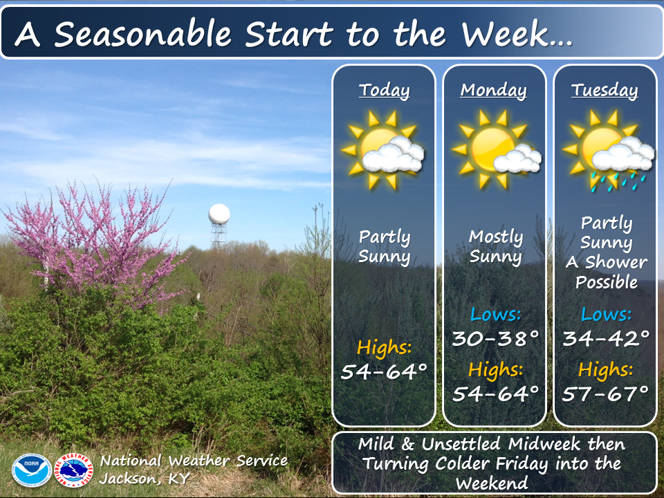
433 FXUS63 KJKL 300130 AFDJKL AREA FORECAST DISCUSSION National Weather Service Jackson KY 930 PM EDT Tue Apr 29 2025 .KEY MESSAGES... - Above normal temperatures will persist through Friday, followed by below normal temperatures over the weekend. - The potential for showers and thunderstorms arrives this afternoon and continues at times through early Saturday. - Some storms late this afternoon and evening may be strong to severe, with strong to damaging winds and heavy rain the primary threats. Hail or a brief spinup tornado cannot be ruled out. - Some of the thunderstorms on Thursday could be strong, with gusty winds and heavy rainfall the primary threats. && .UPDATE... Issued at 929 PM EDT TUE APR 29 2025 A band of thunderstorms is dropping slowly south southeast through the middle of the forecast area. Some cells are occasionally pulsing for a severe threat (mainly wind). Have updated the POP for latest radar trends and model runs, with the current activity dropping further south and weakening late this evening, but redeveloping over our southern counties overnight. && .SHORT TERM...(This evening through Wednesday night) Issued at 300 PM EDT TUE APR 29 2025 CAMS are in excellent agreement on the current MCS traversing out of Missouri into southern Illinois and far western Kentucky combining with new downstream convection over central and northern Kentucky to move across the forecast area this evening. By that time, a moderately unstable environment may exist across western and northwestern parts of the forecast area, with CAPE values of 2000 to 3000 J/kg possible. Additionally, 25 to 35 kts of effective wind shear will support the potential for strong to severe storms, with the highest risk along and north of Interstate 64, with decreasing risk toward the Virginia border. Strong to damaging winds will be the primary severe risk, with large hail a secondary threat. Heavy rainfall will also be possible, but with no impact on area streams or rivers expected. An isolated tornado also cannot be completely ruled out, but is not expected. Thunderstorm activity gradually diminishes after midnight as the cold front gradually moves into northeastern and east-central Kentucky from the north, with widespread low ceilings and light rain/showers expected by Wednesday morning across the north, with potential residual showers across the southern counties. The front stalls across the central part of the forecast area by Wednesday afternoon before lifting north as a warm front late Wednesday into Wednesday ahead of an approaching upper trough that will pass Thursday. With the front over the forecast area Wednesday, another round of showers and thunderstorms is expected, with low to moderate instability again expected by late morning into the afternoon. A passing shortwave late in the morning into the afternoon may provide just enough shear for a stronger storm or two to develop north of a Somerset-to-Salyersville line within an overall environment of scattered to numerous showers and thunderstorms. Damaging winds would again be the primary threat. A brief reprieve from shower and thunderstorm activity is possible late Wednesday into the first half of Thursday as ridging builds ahead of the approaching upper disturbance that will cross the area Thursday. .LONG TERM...(Thursday through Tuesday) Issued at 300 PM EDT TUE APR 29 2025 An energetic upper trough lifts northeast out of Texas through the Ohio River Valley Thursday into Thursday evening, with an amplified upper trough and second cold front following about 24 hours later Friday night into early Saturday. This will bring continued unsettled weather to the region with several rounds of showers and thunderstorms Thursday through Friday night. The Thursday threat will be accompanied by a cold front and will bring with it at least some threat for strong to severe storms, with damaging winds again the primary threat, but it is looking possible that an isolated strong storm or two will be possible even on Friday if sufficient moisture advection can occur behind the Thursday cold front passage. A much cooler and drier regime builds across the area for the weekend behind the departing cold front Saturday morning, with temperatures below normal for the weekend. After bottoming out Saturday and Saturday night, temperatures gradually rise back toward normal into early next week. However, there may be some frost potential in some of the deeper sheltered valleys in the northeastern part of the forecast area Saturday night and perhaps again Sunday night, though this is very low confidence at this time. && .AVIATION...(For the 00Z TAFS through 00Z Thursday evening) ISSUED AT 929 PM EDT TUE APR 29 2025 A band of thunderstorms is dropping south southeast through the JKL forecast area this evening, affecting much of the area except near the TN and VA borders at the start of the period at 00Z. The activity will continue shifting south southeastward this evening, with models suggesting it diminishes to some extent but then redevelops overnight over southeast KY and the Cumberland drainage basin, before eventually mostly dying out on Wednesday morning. The thunderstorms will bring localized IFR or worse conditions. Outside of heavier precipitation, mainly VFR conditions are expected until the overnight hours. Between about 05Z and 10Z, largely MVFR ceilings are forecast to overtake most of the area and last into Wednesday morning before largely dissipating by around mid day. Another increase in showers/thunderstorms may occur on Wednesday afternoon, but there is less confidence as to how this evolves. && .JKL WATCHES/WARNINGS/ADVISORIES... None. && $$ UPDATE...HAL SHORT TERM...CMC LONG TERM...CMC AVIATION...HAL |
||||||||||||||