


Weather Hazards and SafetyTips
Published 2025-03-09
Wet and Cold Winter at Jackson and London
Published 2025-03-05
March 1-7, 2025 is Severe Weather Awareness Week in Kentucky!
Published 2025-03-01
Kentucky Statewide Tornado Drill on Friday, March 7th at 10:07am EST
Published 2025-02-28
Widespread Flooding Occurred Across Kentucky in Mid February 2025. See the Details Here.
Published 2025-02-17
Jackson and London Wetter and Much Colder Than Normal for January
Published 2025-02-05
Normals, Means and Extremes for February
Published 2025-01-31
Annual and December Climate Summaries for Jackson and London
Published 2025-01-03
Normals, Means and Extremes for January
Published 2024-12-31
Tracking Santa Christmas Eve
Published 2024-12-24
Warmer and Drier Conditions across eastern Kentucky for November 2024
Published 2024-12-06
December 1-7 is Winter Weather Awareness Week in Kentucky - Are You Prepared!?
Published 2024-12-01
December 1-7 is designated as Winter Weather Awareness Week across Kentucky. Find out more information here, and also check us out on social media throughout the week for Winter Weather related information!
Normals, Means and Extremes for December
Published 2024-11-30
Warmer than Normal October ends as Driest Ever October at Jackson
Published 2024-11-01
Normals, Means and Extremes for November
Published 2024-10-31
Winter Outlook
Published 2024-10-19
Warmer and Wetter Than Normal September Across Eastern Kentucky
Published 2024-10-03
Normals, Means and Extremes for October
Published 2024-10-03
Soliciting Comments on the Discontinuation of the Max/Min Temp & Precip Table (RTP)
Published 2024-10-03
2024 Fall Weather Safety
Published 2024-09-15
Check out Hurricane Francine and other tropical information from National Hurricane Center
Published 2024-09-10
Summer Warmer Than Normal Across Eastern Kentucky
Published 2024-09-03
Normals, Means and Extremes for September
Published 2024-08-31
Warm and wet July across eastern Kentucky
Published 2024-08-05
Normals, Means and Extremes for August
Published 2024-07-31
Warm June Across Eastern Kentucky
Published 2024-07-02
Normals, Means and Extremes for July
Published 2024-06-30
June 23-29 is National Lightning Safety Awareness Week
Published 2024-06-23
Planning A Beach Trip This Summer? Here's Some Beach Safety Tips
Published 2024-06-04
Warm and Dry Spring at Jackson and London
Published 2024-06-01
Normals, Means and Extremes for June
Published 2024-05-31
Warm and Dry April at Jackson and London
Published 2024-05-02
Normals, Means and Extremes for May
Published 2024-05-02
Please Note: Morgan County's Weather Preparedness Class has been canceled!
Published 2024-04-30
Stay tuned, we will be rescheduling for a later date!
Warm and Dry March at Jackson and London
Published 2024-04-04
Normals, Means and Extremes for April
Published 2024-04-04
Enhanced to Moderate Risk of Severe Thunderstorms Today
Published 2024-04-02
Tornado Safety
Published 2024-04-02
Severe Thunderstorm Safety
Published 2024-04-02
Spring Flood Water and Resources Outlook #3
Published 2024-03-14
Warm and Wet Winter/February at Jackson and London
Published 2024-03-07
12th Anniversary of the March 2, 2012 Tornado Outbreak
Published 2024-03-02
Normals, Means and Extremes for March
Published 2024-02-29
March 1-7, 2023 is Severe Weather Awareness Week across Kentucky! Are you prepared?
Published 2024-02-27
Wetter and Colder January Across Eastern Kentucky
Published 2024-02-01
Normals, Means and Extremes for February
Published 2024-02-01
Eastern Kentucky's Top 5 Weather Events in 2023
Published 2024-01-05
2023 Warmest and 10th Driest Year at Jackson
Published 2024-01-04
Normals, Means and Extremes for January
Published 2023-12-31
Observed Christmas Day Weather at the NWS Jackson, KY Office Since 1981
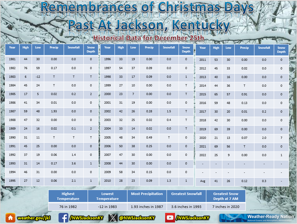
Published 2023-12-22
Here's a look at Christmas Day Weather Data at the Jackson Weather Office since it opened back in 1981.
Winter Weather Safety and Preparedness
Published 2023-12-18
As we continue through the winter season, make sure you are prepared. This website has many great resources for winter safety and preparedness. Feel free to look at it, share it...but most importantly - USE IT! Happy Winter!
The Month of November ranges in the Top 10 driest at both Jackson and London
Published 2023-12-01
Skywarn Recognition Day 2023 is on December 2nd!!!
Published 2023-11-30
Are you a trained spotter/HAM Radio operator? 1) Thank you for helping the NWS! 2) December 2nd is #Skywarn23 - A day to acknowledge you! 3) Help us show the world the amazing spotter network we have by checking into this map on December 2nd!
Normals, Means and Extremes for December
Published 2023-11-28
New! National Water Prediction Service (NWPS) is Available for Preview and Feedback!
Published 2023-11-21
Warmer and Much Drier than Normal October at Jackson and London
Published 2023-11-01
Normals, Means and Extremes for November
Published 2023-10-31
U.S. Winter Outlook: Above Normal Temperatures and Equal Chances of Precipitation Favored for Eastern KY
Published 2023-10-20
Congratulations to McCreary Central High School on being awarded the 2023 Weather Ready Nation Ambassador of Excellence for eastern Kentucky!!!
Published 2023-10-16
Join us for a Community Weather Preparedness Event in London, KY on October 17!
Published 2023-10-10
Warmer and Much Drier than Normal September at Jackson and London
Published 2023-10-01
Normals, Means and Extremes for October
Published 2023-09-30
Check out our latest weather safety graphics, videos, social media posts and more for the Fall
Published 2023-09-02
Cooler than Normal Summer and August Across Eastern Kentucky
Published 2023-09-01
WWG-61 NWR Transmitter in Stanton Down for Maintenance
Published 2023-08-31
Normals, Means and Extremes for September
Published 2023-08-31
Normals, Means and Extremes for August
Published 2023-08-03
Drier than normal conditions across eastern Kentucky
Published 2023-08-01
Skywarn Storm Spotter Training is TONIGHT (August 8th, 2023) in northern McCreary County!
Published 2023-07-28
A look back on the historic July 2022 Flooding
Published 2023-07-28
Today we reflect back on this past year since the historic flooding that impacted our lives forever. Our hearts are with eastern Kentucky. For a look back on the event, visit www.weather.gov/jkl/July2022Flooding
Cooler than Normal June at Jackson and London
Published 2023-07-04
Normals, Means and Extremes for July
Published 2023-06-28
Summer Weather Safety
Published 2023-06-25
Slight to Enhanded Risk of Severe Thunderstorms Late This Evening Into Tonight
Published 2023-06-25
Feedback Requested through 6/16! Take the NWS Survey on the Display of Future Plain Language Headlines HERE...
Published 2023-06-06
Check out our latest weather safety graphics, videos, social media posts, and more for the Summer
Published 2023-06-01
Normals, Means and Extremes for June
Published 2023-05-30
NOAA Predicts a Near Normal 2023 Atlantic Hurricane Season
Published 2023-05-25
Large Hail, Damaging Winds, and a Tornado Affect Eastern Kentucky on Tuesday, May 16th, 2023
Published 2023-05-21
14th Anniversary of May 8th-9th, 2009 Severe Flash Flooding In Owsley, Breathitt, Floyd, and Pike Counties
Published 2023-05-09
April at Jackson was Warmer and Drier than Normal
Published 2023-05-01
Normals, Means and Extremes for May
Published 2023-05-01
Frost Advisory in Effect from 2 AM TO 9 AM EDT Monday
Published 2023-04-09
Warm and Dry March at London and Jackson
Published 2023-04-01
Normals, Means and Extremes for April
Published 2023-04-01
30th Anniversary of Blizzard of 1993
Published 2023-03-13
March 3: Powerful Storm System Brings Damaging Winds
Published 2023-03-11
Warmest Winter and February at Jackson
Published 2023-03-01
Normals, Means and Extremes for March
Published 2023-03-01
Wetter and Much Warmer Than Normal January at Jackson and London
Published 2023-02-02
Normals, Means and Extremes for February
Published 2023-02-02
Top 5 Weather Events of 2022
Published 2023-02-02
2022 Severe Weather Year In Review
Published 2023-02-01
When to Expect the Coldest Day of the Year
Published 2023-02-01
Earth from Orbit: NOAA’s GOES-18 is now GOES West
Published 2023-01-06
Wetter and Warmer Than Normal 2022 at Jackson
Published 2023-01-01
Normals, Means and Extremes for January
Published 2022-12-31
Winter Driving: Watch Out For These 4 'Sneaky' Hazards
Published 2022-12-28
How Do Snowflakes Form? Get the Science Behind Snow
Published 2022-12-28
Track Santa Here!!!
Published 2022-12-25
Minimum Wind Chill Reports
Published 2022-12-23
Winter Weather Safety
Published 2022-12-06
Skywarn Storm Spotter Day 2022
Published 2022-12-01
Are you a trained Weather Spotter or HAM Radio Operator? We want to celebrate YOU! Skywarn Recognition Day is coming up on December 3rd!
Fall 2022 Dry and Cool at Jackson
Published 2022-12-01
Normals, Means and Extremes for December
Published 2022-12-01
NOAA’s Newest Satellite Heads Toward Orbit
Published 2022-11-11
Dry and Cool October Across Eastern Kentucky
Published 2022-11-01
Normals, Means and Extremes for November
Published 2022-10-31
10th Anniversary of Superstorm Sandy's Impacts on East KY
Published 2022-10-30
2022 - 2023 U.S. Winter Outlook: Equal Chances Forecast for Eastern KY
Published 2022-10-20
Damaging Thunderstorm Winds Hit Bath County on October 12
Published 2022-10-17
NWS Jackson KY KJKL Radar SLEP Upgrade/Radar Outage Through October 21, 2022
Published 2022-10-14
NWS Jackson, Radar Life Extension Program (SLEP) Upgrade and Downtime Beginning 14 October 2022, the KJKL WSR-88D radar operated by the National Weather Service in Jackson, KY will be down for approximately 7 days for the replacement of the generator, fuel tanks, and accompanying components. This generator update is part of SLEP, that will keep the radar viable into the 2030s.
Eastern Kentucky Saw Dry and Cool Conditions During September
Published 2022-10-01
***Cancelled-Advanced Skywarn Spotter Training To Be Held December 9th In Mount Vernon, KY-Cancelled***
Published 2022-09-30
Normals, Means and Extremes for October
Published 2022-09-30
Congratulations to WYMT News: Our 2022 Weather Ready Nation Ambassador of Excellence!
Published 2022-09-27
Earth Had Its 6th-Warmest August in 143 Years of Records
Published 2022-09-15
2nd Wettest and 8th Hottest Summer at Jackson
Published 2022-09-01
Normals, Means and Extremes for September
Published 2022-08-31
Skywarn Spotter Training To Be Held September 29th In Harlan, KY
Published 2022-08-31
NOAA Still Expects Above-Normal Atlantic Hurricane Season
Published 2022-08-24
Hurricane Andrew at 30: Where science Has Taken Us
Published 2022-08-24
Severe Thunderstorms Possible This Afternoon and Evening
Published 2022-08-21
Flood Watch Through Late This Evening
Published 2022-08-09
A slow moving cold front will lead to the development of showers and thunderstorms at times across eastern Kentucky through Wednesday, with excessive rainfall a concern.
Heavy Rain Threat / Flood Watches Through Friday Night
Published 2022-08-05
Heat Threat Through Thursday
Published 2022-08-03
Heat Returns for Wednesday and Thursday
Published 2022-08-02
Historic July 26th-July 30th, 2022 Eastern Kentucky Flooding
Published 2022-08-02
Flood Watch Late This Evening Into Tuesday Morning
Published 2022-08-01
A cold front working across the OH Valley will lead to showers and thunderstorms later this evening and into tonight. These will produce heavy rain rates leading to a threat for more flooding.
Wettest July on record for Jackson, 8th wettest July on record for London
Published 2022-08-01
Normals, Means and Extremes for August
Published 2022-07-31
Major Flooding Ongoing Across Eastern Kentucky
Published 2022-07-29
Many areas have seen or area seeing major flooding across eastern Kentucky over the past several days. Additional flash flooding will be possible tonight into Friday.
Fourth Warmest June for Jackson
Published 2022-07-01
Normals, Means and Extremes for July
Published 2022-07-01
10 Years Ago Eastern Kentucky Brushed by a Powerful Derecho - June 29th, 2012
Published 2022-06-30
10 Years Ago Eastern Kentucky Brushed by a Powerful Derecho - June 29th, 2012
Severe Thunderstorms on Friday 6/17/2022 Produce Damaging Wind Gusts Across Much of Eastern KY
Published 2022-06-20
NWS Summer Safety Campaign Started June 1st
Published 2022-06-20
Want to take an IN-PERSON spotter class!? We have 1 coming up on June 21 in Estill County! Click here for more information...
Published 2022-06-15
7th wettest May at Jackson and 8th warmest May at London
Published 2022-06-01
Normals, Means and Extremes for June
Published 2022-05-31
NOAA predicts above-normal 2022 Atlantic Hurricane Season
Published 2022-05-26
EF1 Tornado Confirmed in Pulaski County May 6th, 2022
Published 2022-05-08
April was Drier and Cooler than Normal across Eastern Kentucky
Published 2022-05-01
Normals, Means and Extremes for May
Published 2022-05-01
Freeze Warning/Frost Advisory in Effect Late Tonight/Early Wednesday
Published 2022-04-19
Are You Prepared for Spring Weather Hazards?
Published 2022-04-07
Severe Thunderstorms Possible Late This Afternoon and Evening
Published 2022-04-06
Locations generally along and south of the Mountain Parkway will have the best chance for seeing severe thunderstorms, with damaging winds the primary threat.
March was Very Dry and Warm Across Eastern Kentucky
Published 2022-04-01
Normals, Means and Extremes for April
Published 2022-04-01
Spring Outlook: Drought In Plains and Western U.S. to Expand Amid Warmer Conditions
Published 2022-03-19
Wintry Weather Returns Late Tonight Into Saturday
Published 2022-03-10
Top 5 Weather Events of 2021
Published 2022-03-09
Warm Winter Across Eastern Kentucky
Published 2022-03-02
10th Anniversary of the March 2nd, 2012 Tornado Outbreak
Published 2022-03-02
We revisit the March 2nd, 2012 tornado outbreak on the 10-year anniversary.
Normals, Means and Extremes for March
Published 2022-03-02
Heavy Rain Threat Through Early Friday
Published 2022-02-24
U.S. Saw Its Coolest, Driest January in 8 years
Published 2022-02-14
Winter Storm Brings Significant Icing North of I-64 and on Higher Ridges of the East Kentucky Coalfield (February 3rd and 4th)
Published 2022-02-07
World's Longest Lightning Flash On Record Captured By NOAA Satellites
Published 2022-02-06
Wintry Precipitation Affecting Eastern Kentucky This Morning
Published 2022-02-03
A wintry mix of freezing rain, sleet, and snow will affect Eastern Kentucky this morning. Ice accumulations are expected to average a tenth of an inch or less, with snow and sleet accumulations of less than an inch.
Very Wet January with Colder than Normal Temperatures
Published 2022-02-02
Normals, Means and Extremes for February
Published 2022-02-02
Cold Front and Upper Level Disturbance Bring Snow to Eastern KY (1/27/2022 to 1/29/2022)
Published 2022-01-29
February Outlook: On Average Above Normal Temperatures and Above Normal Precipitation Favored Across East KY
Published 2022-01-20
Rain Changes To Snow 01/19/2022 to 01/20/2022
Published 2022-01-20
A passing cold front allowed for the change over to snow during the late evening hours of the 19th and into the early morning hours of the 20th. Snowfall in most locations generally ranged from 1 to 3 inches, with locally higher amounts near the I-64 corridor.
Rain and Freezing Rain Changed to Heavy Wet Snow - The January 16th to January 17th Winter Storm
Published 2022-01-18
Rain Changing to Snow Anticipated This Evening to Early Thursday Morning
Published 2022-01-18
Significant Winter Storm to Affect Eastern KY Through Tonight
Published 2022-01-13
Widespread Heavy Snow Falls Across Eastern Kentucky 1/6/2022 to 1/7/2022
Published 2022-01-08
Heavy snow developed across eastern Kentucky on Thursday, January 6th as potent low pressure system developed over the Deep South in the morning, rode up the spine of the southern Appalachians during the afternoon, and off to the northeast Thursday night - a climatologically favored track for heavy snow accumulations across eastern Kentucky.
Widespread Heavy Snow Falls Across Eastern Kentucky on 1/6/2022
Published 2022-01-07
Snow Tapering off From West to East
Published 2022-01-05
2021 Ends Warm with the 2nd Warmest Decembers at Jackson and London
Published 2022-01-04
Normals, Means and Extremes for January
Published 2022-01-04
First Winter Storm of the 2021-2022 Snow Season Leaves Winter Wonderland across Portions of Southeast Kentucky
Published 2022-01-04
EF-1 Tornado Confirmed in Estill County on New Years Day 2022
Published 2022-01-03
NWS storm survey team found damage that was the result of an EF-1 tornado with maximum wind speeds estimated at 95 mph. Numerous trees were snapped or uprooted, a barn was collapsed, and the roof of an auto repair facility was damaged.
Second Latest Date of First Measurable Snowfall at Jackson, KY
Published 2022-01-03
U.S. Winter Outlook: Drier, warmer South, wetter North with return of La Nina
Published 2022-01-02
Heavy Rainfall For The New Year
Published 2021-12-31
A stalled boundary across the region will lead to widespread heavy rainfall for much of Kentucky through tonight. A flood watch has been issued for portions of eastern Kentucky and points westward, where the best potential for excessive rainfall exists. Generally 1 to 3 inches is expected across eastern Kentucky during the duration of the event.
The December 2021 Tornado Outbreak Explained
Published 2021-12-21
Damaging Wind Gusts Possible Late Tonight From Severe Storms
Published 2021-12-10
Severe weather damaging winds gusts
We want YOUR feedback on NWS Frost and Freeze products!! Survey closes December 18.
Published 2021-12-06
Very Dry Fall Across East Kentucky
Published 2021-12-01
Normals, Means and Extremes for December
Published 2021-12-01
Light Snow Accumulations and Slick Spots Possible For Elevations Above 2000 Feet Late Tonight and Friday Morning
Published 2021-11-25
Are you a trained Weather Spotter or HAM Radio Operator? We want to celebrate YOU! Skywarn Recognition Day is coming up on December 4th!
Published 2021-11-24
2-pager: La Nina Impacts and Outlook for the Midwest/Ohio Valley
Published 2021-11-19
October 2021 Much Warmer than Normal at Jackson and London
Published 2021-11-01
Normals, Means and Extremes for November
Published 2021-11-01
9th Anniversary of Super Storm Sandy's Impacts on Eastern Kentucky
Published 2021-10-29
The major storm system created as Hurricane Sandy merged with a strengthening upper level disturbance brought wide ranging and severe impacts to the eastern United States between Sunday October 28th and Wednesday October 31st. Record storm surge, damaging hurricane force winds, inland flooding and blizzard conditions were all reported with the storm. Snow fell across portions of East KY.
A Threat for Damaging Wind Gusts Today
Published 2021-10-24
Severe threat for Damaging Wind Gusts today
September Drier with Near Normal Temperatures Across Eastern Kentucky
Published 2021-10-01
Normals, Means and Extremes for October
Published 2021-10-01
NWS Jackson, KY Incident Meteorologists Support Western Wildfires
Published 2021-09-26
NWS Jackson, KY Incident Meteorologists (IMETs) have deployed to western wildfires during
Congratulations to WYMT: Our 2021 Weather Ready Nation Ambassador of Excellence!
Published 2021-09-21
Very Wet and Warm Summer Across Eastern Kentucky
Published 2021-09-02
Normals, Means and Extremes for September
Published 2021-09-02
Meteorological Autumn is Here!!! Check Out The Latest Fall Safety Information!
Published 2021-09-01
Flash Flood Watch In Effect for Much of Southeast Kentucky
Published 2021-08-17
Tropical Depression Fred will bring heavy rains to portions of the Appalachians. A good portion of southeast Kentucky could see between 1 to 2 inches of rainfall, with locally higher amounts possible. A Flash Flood Watch is in effect through 11 AM EDT Wednesday for this area.
Normals, Means and Extremes for August
Published 2021-08-04
Wetter than Normal July with near normal Temperatures across Eastern Kentucky
Published 2021-08-04
9th Warmest June for Jackson and 14th Wettest June for London
Published 2021-07-01
Climate Normals
Published 2021-07-01
Let Your Voice Be Heard! The NWS is soliciting feedback through July 31, 2021 on proposed new Plain Language Headlines.
Published 2021-06-25
Strong to Severe Thunderstorms Possible Into This Evening
Published 2021-06-13
storms, severe, damaging winds
Drier than normal Spring and May Across Eastern Kentucky
Published 2021-06-01
Normals, Means and Extremes for June
Published 2021-06-01
Get ready for Summer weather hazards by visiting our Summer Safety website!Â
Published 2021-06-01
Strong Thunderstorms Possible Today
Published 2021-05-28
Windy Through Early This Evening
Published 2021-05-08
Frost Advisory Along I-64 Early Saturday Morning
Published 2021-05-07
April Dry and Cool Across Eastern Kentucky
Published 2021-05-01
Normals, Means and Extremes for May
Published 2021-05-01
Freeze Warning and Frost Advisory in effect late Tonight into Friday morning.
Published 2021-04-20
March warm and wet across eastern Kentucky
Published 2021-04-01
Normals, Means and Extremes for April
Published 2021-04-01
Heavy Rains Expected Late Tonight into Wednesday - Especially South
Published 2021-03-30
FFW, Heavy rain, flash flooding
Severe Thunderstorms Possible Tonight
Published 2021-03-25
A strong cold front will bring a threat of severe thunderstorms to east Kentucky tonight. Damaging winds will be the main threat; however, isolated tornadoes are also possible, especially along and west of I-75. Isolated flash flooding will also be possible, where thunderstorms persist. Outside of thunderstorms, strong south to southwest winds will occur tonight and a wind advisory is in effect.
Slight Risk of Severe Thunderstorms on Thursday
Published 2021-03-24
Strong to Severe Thunderstorms Possible This Afternoon
Published 2021-03-17
Virginia Statewide Tornado Drill on Tuesday, March 16th at 9:45 AM EDT
Published 2021-03-12
Second wettest February on record for Jackson and Fifth wettest for London
Published 2021-03-04
Climate Normals, Means and Extremes for March 2021
Published 2021-03-04
Several Rounds of Heavy Rain Cause Major Flooding Across East Kentucky (Event Summary; February 27th - March 1st)
Published 2021-03-04
Rounds of Moderate to Heavy Rain Through Sunday Night
Published 2021-02-27
Flood watch and between 2-4 inches of QPF expected across eastern Kentucky this weekend. Flash Flooding and River Flooding potential.
Another Winter Storm Impacts the Region This Evening Through Thursday
Published 2021-02-16
Another storm system is expected to lead to moderate to heavy snow and some icing from this evening to Thursday evening. Some uncertainty remains with the track and timing of this system, which will ultimately determine duration of precipitation types or types in any given location. Continue to monitor the forecast for additional details and updates.
Lingering Affects of Departing Winter Storm Continues
Published 2021-02-15
Precipitation has tapered to a mix of freezing drizzle and flurries. However, power outages continue and new outages are possible. Trees and tree limbs continue to fall and numerous roads are blocked and many roads remain icy and untreated. Travel this morning will be difficult to nearly impossible in many areas.
Winter Storm Through Early Tuesday
Published 2021-02-13
A significant winter storm is expected to impact eastern Kentucky through early Tuesday. Freezing rain, sleet, and some snow are all expected. Power outages, tree damage, and difficult to nearly impossible travel conditions will occur.
Black Ice and Patchy Freezing Drizzle Through Early This Morning
Published 2021-02-12
Heavy Snow Blankets Portions of Southeast Kentucky Early Sunday
Published 2021-02-07
Accumulating Snow Ending this Morning
Published 2021-02-06
January was Warmer and a little Drier Than Normal
Published 2021-02-03
Normals, Means and Extremes for February
Published 2021-02-03
64th Anniversary of the Flood of 1957
Published 2021-01-29
Devastating floods occurred across southeastern Kentucky, southwestern West Virginia, western Virginia, and northeastern Tennessee in late January and early February of 1957. In eastern Kentucky, the headwaters of the Big Sandy, Kentucky and Cumberland Rivers were especially hard hit.
Wintry Mix Possible Along and North of I-64 This Morning
Published 2021-01-24
Widespread Snow Continuing for a Few Areas This Morning
Published 2021-01-19
Widespread light snow will continue for some areas through the morning hours. All of the snow should end by early afternoon, but a few flurries could linger behind. Some light additional snow accumulations will be possible this morning. Slick spots will remain a possibility through the morning hours. Exercise caution if traveling.
Snow Showers Through Tonight
Published 2021-01-15
Scattered to numerous snow showers will impact eastern Kentucky through tonight. The snow showers may mix with rain this afternoon. Light accumulations are possible, mainly tonight.
2020 Warmer and Wetter Than Normal Across Eastern Kentucky
Published 2021-01-07
Normals, Means and Extremes for January
Published 2021-01-07
Heavy Snow on Christmas Eve Provides a Rare White Christmas for East Kentucky
Published 2020-12-27
Public Forecast Line for NWS Jackson, Kentucky Repaired
Published 2020-12-26
The (606)666-8000 phone number with access observational, forecast, and climate information has been repaired.
Christmas Eve Winter Storm
Published 2020-12-23
A potent storm system will bring moderate to heavy accumulating snowfall to eastern Kentucky this afternoon into tonight. This will affect the evening commute. A winter storm warning and winter weather advisory remain in effect mainly from this afternoon through early Christmas morning.
Remembrances of Christmas Days Past
Published 2020-12-20
Snow Across the Higher Elevations of Southeastern Kentucky This Morning
Published 2020-12-14
Snow across the higher elevations of southeastern Kentucky will taper off from west to east this Monday. For elevations above 2000 feet, 1 to 4 inches of storm total snowfall accumulation is expected, leading to a slick Monday morning commute.
Please Help Us By Providing Feedback on Frost and Freeze Products (Due by December 17th)
Published 2020-12-06
The First Accumulating Snowfall of the Season is Expected Continue Through Tuesday
Published 2020-11-29
A potent storm system has pushed colder air into eastern Kentucky, resulting in snow across the area. Light snow accumulations are expected through mid-day Tuesday.
Red Flag Warning Today
Published 2020-11-19
November 15th, 2020 Strong Cold Front - Peak Wind Gusts
Published 2020-11-16
Strong Winds Today
Published 2020-11-14
SKYWARN Recognition Day Ongoing (All Virtual This Year)
Published 2020-11-08
End of the 2020 Frost/Freeze Program
Published 2020-11-02
October Saw Warmer Than Normal Temperatures and Near Normal Precipitation Across Eastern Kentucky
Published 2020-11-01
Normals, Means and Extremes for November
Published 2020-10-31
Freeze Warning In Effect Through 10 AM This Morning
Published 2020-10-31
The Remnants of Zeta Bringing Periods of Moderate to Heavy Rains to Southeastern Kentucky Through Early Afternoon
Published 2020-10-29
NOAA Climate Prediction Center Just Released Their Winter Outlook for 2020/2021!
Published 2020-10-17
The NOAA Climate Prediction Center just released their outlook for this upcoming Winter 2020/2021. It looks like eastern Kentucky will be favoring a warmer but wetter than normal winter. Read more about it here...
Frost / Near Freezing Temperatures Likely Tonight into Saturday Morning
Published 2020-10-15
The first significant frost of the fall is expected tonight into Saturday morning. Those with sensitive plants should take action now to protect them.
Fall Frost/Freeze Climatology
Published 2020-10-05
Normals, Means and Extremes for October
Published 2020-10-01
Near Normal Temperatures and Wetter Than Normal September Across Eastern Kentucky
Published 2020-10-01
Congratulations To The East Kentucky Science Center For Being One Of The 2020 Weather Ready Nation Ambassadors of Excellence
Published 2020-09-21
Recap of Heavy Rain and Flooding September 12th-13th
Published 2020-09-15
Climate Normals/Monthly and Seasonal Climate Summaries for Jackson and London
Published 2020-09-01
Follow Along With This Already Active Tropical Season
Published 2020-09-01
Prepare Now for Fall Weather Hazards
Published 2020-09-01
Have a Meteorologist Virtually Visit Your Classroom! Find Out More Here...
Published 2020-08-27
Summer Safety Information
Published 2020-08-01
Live Virtual Severe Weather Spotter Class Scheduled for July 21, 2020 with WYMT
Published 2020-07-10
Statewide Air Quality Warning for Kentucky Through Sunday
Published 2020-06-27
Join us to talk about Summer Weather Hazards & Safety from 11:30 a.m. - Noon Today!
Published 2020-06-23
Lightning Safety Awareness Week: June 21-27
Published 2020-06-21
Preliminary Storm Reports from June 10th, 2020
Published 2020-06-11
Severe thunderstorms affected portions of eastern KY in advance of a cold front during the late afternoon and evening hours of June 10th, 2020. A summary of reports is below:
Slight Risk of Severe Thunderstorms Today
Published 2020-06-10
Isolated to scattered severe thunderstorms are forecast this afternoon and evening. Strong to damaging wind gusts, hail, and heavy rain will be the primary threats. However, an isolated tornado is also possible.
May 2020 East KY Climate Summary
Published 2020-06-01
May is officially in the record books! It was wet, with at least a trace of rain reported each day for 2/3 of the month. London even ended up 4" above normal for rainfall while rainfall at Jackson was near normal. Despite some warm days, a record cold snap at the start of the month and below normal temperatures to end the month kept our average temps below normal.
In Depth Review of April 12-13th Wind Event
Published 2020-05-22
Busy Atlantic Hurricane Season Expected
Published 2020-05-21
Boating Safety
Published 2020-05-16
Record-Breaking Arctic Air Mass Brings Late-Season Freeze Across Eastern Kentucky on May 9-10th, 2020
Published 2020-05-10
Another Frost and Valley Freeze Tonight
Published 2020-05-09
Valley temperatures will dip into the 20s to low 30s again late tonight and early Sunday morning. Frost is anticipated.
Hard Freeze Early This Morning and Another Frost or Freeze Tonight
Published 2020-05-08
A hard freeze is ongoing this morning. Valley temperatures will dip into the 20s to low 30s again Saturday night as well with frost anticipated.
April 2020 Climate Summary for Jackson, KY and London, KY
Published 2020-05-02
April was colder and wetter than average across East KY.
East KY's Inaugural Severe Weather Awareness Day
Published 2020-04-21
Frost Advisory Late Tonight Into Wednesday Morning
Published 2020-04-21
Freeze Warning Late Tonight Into Wednesday Morning
Published 2020-04-14
Widespread subfreezing temperatures are expected late tonight. A freeze warning has been issued.
Widespread Strong Winds Blow Through East Kentucky on April 12-13, 2020
Published 2020-04-13
Learn About the Weather Here!
Published 2020-04-13
Severe Thunderstorm Potential Tonight
Published 2020-04-12
Strong to severe thunderstorms are possible tonight as a strong low pressure system tracks west of the East KY.
Strong Wind Gusts Through Early Afternoon
Published 2020-04-12
A wind advisory will continue through early afternoon.
Dual Rounds of Severe Thunderstorms Hit Eastern Kentucky on April 8 & 9
Published 2020-04-10
Freeze Warning Late Tonight Through Saturday Morning
Published 2020-04-10
A Freeze Warning has been issued for tonight into Saturday Morning.
Freeze Watch Late Friday Night Through Saturday Morning
Published 2020-04-10
A Freeze Watch has been issued for Friday night Through Saturday Morning.
Severe Storms Possible This Afternoon Through Late Tonight
Published 2020-04-08
A few severe storms capable of hail and damaging winds will be possible this afternoon. The better threat for more organized severe weather will come late this evening into the overnight hours as a complex of storms pushes east across the region. Damaging winds, large hail, and a brief tornado will all be possible.
Strong to Severe Thunderstorms Possible Tonight and Wednesday
Published 2020-04-07
Severe graphics for tonight and Wednesday
Join Us For a Virtual Spotter Training Session April 9th, 6-7:30 pm EDT (All Are Welcome)
Published 2020-04-02
Join Us For a Virtual Educational Weather Talk on April 7th @ 11 am (All Ages Welcome)
Published 2020-04-01
Recording of Facebook Live Weather Spotter Class from March 25, 2020
Published 2020-03-22
U.S. Spring River Flood Outlook
Published 2020-03-19
Summary of Whitley City Tornado on March 12th
Published 2020-03-13
Wet February across eastern Kentucky
Published 2020-03-01
Winter Weather Advisory In Effect
Published 2020-02-28
Normals, Means and Extremes for March
Published 2020-02-27
Flood Threat Will Continue Into This Morning
Published 2020-02-10
Steady rain will continue across east Kentucky through the early morning hours today. Some additional flooding will be a possibility.
Major Flooding Inundates Southeast Kentucky Followed by Light Snow From February 6-7
Published 2020-02-10
150th Anniversary of the National Weather Service
Published 2020-02-07
Snow Will Continue Through Early Afternoon Today
Published 2020-02-06
Flooding Continues for Much of Southeast Kentucky
Published 2020-02-06
Recent heavy rainfall and continued light to moderate rain is leading to ongoing flooding and portions of eastern Kentucky are dealing with significant river flooding.
January Much Warmer Than Normal Across Eastern Kentucky
Published 2020-02-01
Normals, Means and Extremes for February
Published 2020-02-01
Top 10 Weather Events of the Decade Ranging from 2010-2019
Published 2020-01-22
Join Us at the East KY Science Center in Prestonsburg on March 7 to Learn About Severe Weather!
Published 2020-01-17
Strong to Damaging Winds Blow Across Eastern Kentucky on January 11, 2020
Published 2020-01-14
Twenty-four Hour Snowfall Totals for January 7, 2020
Published 2020-01-07
2019 Top 5 Weather Events
Published 2020-01-06
Light Snow This Morning
Published 2020-01-06
Questions on the Use of Flash with NWS Radar
Published 2020-01-06
Temperatures and Precipitation Above Normal for December and 2019
Published 2020-01-01
Normals, Means and Extremes for January
Published 2020-01-01
Heavy Rains Pummeled Eastern Kentucky Overnight From 12/29 to 12/30 - See The Latest Rainfall Totals
Published 2019-12-30
Flood Watch in Effect for Portions of Eastern Kentucky
Published 2019-12-29
A strong storm system will bring moderate to heavy rainfall to eastern Kentucky today and into tonight. A Flood Watch has been issued for portions of eastern Kentucky where up to 2.50 inches of rainfall are possible. This may result in minor flooding of low lying areas.
Flooding Threat Tonight Into Tuesday
Published 2019-12-16
24-Hour Snowfall Totals Ending 12/11/2019
Published 2019-12-11
Warm Autumn but Wet and Cool November
Published 2019-12-01
Normals, Means and Extremes for December
Published 2019-11-30
Strong Winds Bring Power Outages and Some Minor Damage to Eastern Kentucky on Wednesday
Published 2019-11-28
2019 Skywarn Recognition Day December 7th
Published 2019-11-17
A Look Back at The Great Appalachian Storm of 1950
Published 2019-11-17
Some Wintry Weather Expected Tonight/Tuesday
Published 2019-11-10
Severe to Extreme Drought Grips Southeast Kentucky Through September and October
Published 2019-11-07
Wet and Warm October at Jackson and London
Published 2019-11-01
Normals, Means and Extremes for November
Published 2019-11-01
Freeze Watch Late Thursday Night into Friday Morning
Published 2019-10-30
Drought Conditions Being Felt Across East Kentucky
Published 2019-10-18
September 2019 very warm, driest month at Jackson and driest September at London
Published 2019-10-01
Normals, Means and Extremes for October
Published 2019-10-01
Irvine NOAA Weather Radio Transmitter Off Air This Weekend
Published 2019-09-06
Warm and Dry August across eastern Kentucky
Published 2019-09-01
Climate Normals, Means, and Extremes for September
Published 2019-09-01
New Impact Based Flash Flood Warnings Coming This Winter
Published 2019-08-20
http://New Impact Based Flash Flood Warnings Coming This Winter https://www.weather.gov/media/wrn/FFW-IBW-factsheet.pdf
If you’re an educator looking to prepare for the coming school year, click on this link for a collection of resources.
Published 2019-08-04
Wet July at Jackson with seasonable temperatures across eastern Kentucky
Published 2019-08-01
Normals, Means and Extremes for August
Published 2019-08-01
Nationwide Emergency Alert System Test August 7, 2019
Published 2019-07-27
A Look Inside Tornado Alley
Published 2019-07-09
Very wet June across eastern Kentucky with slightly below normal temperatures
Published 2019-07-01
Normals, Means and Extremes for July
Published 2019-06-30
Trio of Thunderstorm Complexes Causes Wind Damage June 21st Through June 24th
Published 2019-06-25
Severe Thunderstorm Watch Until 2 AM
Published 2019-06-19
A severe thunderstorm watch has been issued until 2 am tonight for the shaded areas of eastern Kentucky. Storms are expected to roll into the area after 10 pm, with the threat ending by 2 am. Damaging winds and torrential will be the main impacts from these storms. Be sure to have a way to receive warnings or weather information prior to going to bed tonight.
Severe Thunderstorm Watch in Effect Through 11 p.m. EDT
Published 2019-06-16
Severe thunderstorms will be possible through 11 pm with damaging winds in excess of 70 mph and large hail up to 1.5 inches being the main threats. Locally heavy rain will be secondary threat. Be prepared to seek shelter this evening and have multiple ways to receive warnings. Downed trees and power outages, along with hail damage to vehicles will be possible.
Severe Storms Produce Significant Hail and Damaging Winds on June 5th, 2019
Published 2019-06-06
Severe Thunderstorm Watch Until Midnight
Published 2019-06-05
Severe Tstorm Watch in effect until Midnight. Damaging wind gusts to 60 mph and large hail up to golf ball size are the main threats. Continue to monitor the weather for warnings through the evening.
Spring 2019 and May 2019 Drier and Warmer than Normal at Jackson
Published 2019-06-01
Normals, Means and Extremes for June
Published 2019-06-01
Winds up to 80 mph Cause Damage In Prestonsburg & Far Eastern KY on May 29
Published 2019-05-31
Severe Winds Strike Central Portions of East Kentucky During the Evening of May 26
Published 2019-05-31
Severe Weather Potential Today
Published 2019-05-29
There is a slight risk of severe weather across a large portion of eastern Kentucky today, mainly north of the Hal Rogers Parkway. The primary threats with the strongest storms will be damaging wind gusts, large hail, dangerous cloud to ground lightning, and locally heavy rainfall.
Severe Thunderstorm Watch Until 9 PM
Published 2019-05-26
Severe thunderstorms will be possible through 9 pm with damaging winds in excess of 60 mph being the main threat. Locally heavy rain will be secondary threat. Be prepared to seek shelter this evening and have multiple ways to receive warnings. Downed trees and power outages will be possible.
Flash Flooding Possible in Parts of Eastern Kentucky Tonight
Published 2019-05-04
An area of low pressure is tracking across the Ohio Valley tonight. This system will bring another round of showers and a few thunderstorm to eastern Kentucky tonight. This could lead to locally heavy rainfall and instances of flash flooding for portions of eastern Kentucky.
April 2019 Drier and Warmer than Normal at Jackson and London
Published 2019-05-01
Normals, Means and Extremes for May
Published 2019-05-01
March 2019 Drier and Cooler than Normal at Jackson and London
Published 2019-04-01
Normals, Means and Extremes for April
Published 2019-04-01
Jackson, KY Radar Down this Week for Refurbishment - Click Here for Neighboring Radars
Published 2019-03-18
A Few Severe Storms Possible This Evening
Published 2019-03-14
A few strong storms could develop later this evening. The strongest storms would be capable of damaging winds, but the threat will be very isolated.
Snowfall Reports From This Morning
Published 2019-03-08
Wettest Winter and February at Jackson with Warmer than Normal Conditions
Published 2019-03-01
March 1-7 is Kentucky's Severe Weather Awareness Week
Published 2019-02-28
Normals, Means and Extremes for March
Published 2019-02-28
Heavy Rain/Flooding Possible Through Tonight
Published 2019-02-18
Rounds of rain, moderate to heavy at times, are expected through tonight. A few thunderstorms are also possible. This rain on already saturated soils will lead to rises and flooding of some poor drainage areas. Flooding of creeks, streams, and rivers is also possible. Mud and rock slides are expected.
Flooding Possible Through This Afternoon
Published 2019-02-11
Widespread rainfall will overspread Eastern Kentucky today, bringing the potential for flooding along small streams, creeks, and eventually some of the larger rivers.
Amateur Radio Operator & Avid SKYWARN Spotter Awarded as a Weather-Ready Nation Ambassador of Excellence
Published 2019-02-06
Flooding Possible Through This Morning
Published 2019-02-05
A link to the current weather story and tabs.
Normals, Means and Extremes for February
Published 2019-02-01
Jackson and London end January Warmer and Wetter than Normal
Published 2019-02-01
Bitterly Cold Conditions Continue Through Tonight
Published 2019-01-29
Bitterly cold conditions will continue through tonight with low temperatures falling to around zero degrees in the south and areas north falling below zero. Wind chill values up to 15 below zero are possible in the far north as well. Some light snow will be possible in the south overnight as well. Limit your exposure to the cold through tonight.
Light Accumulating Snow Tonight Into Tuesday Followed By Bitter Cold Air Midweek
Published 2019-01-27
An Arctic cold front moves through the Ohio Valley tonight into Tuesday morning. Expect rain to quickly change over to snow late tonight as bitter cold air rushes in behind the front. A quick burst of wind driven snow will occur with this feature as much of eastern Kentucky receives between 1/2 and 2 inches by Tuesday evening. Bitter cold temperatures are then expected through the day Thursday.
Wintery Precipitation Winding Down Today
Published 2019-01-12
Any remaining snow will mix with or change to rain from south to north during the day. Daytime accumulations will generally be less than an inch.
Wettest Year at Jackson By Over 4 Inches and Other Climate Info
Published 2019-01-01
Normals, Means and Extremes for January
Published 2018-12-31
Windy Conditions Expected Tonight through Friday Morning
Published 2018-12-26
Remembrances of Christmas Days Past (Jackson, KY)
Published 2018-12-18
December 9th Winter Storm Summary
Published 2018-12-10
Winter Storm Affecting Portions of East KY
Published 2018-12-08
A winter storm moving across the Southern States will affect much of East KY today with rain or mixed wintry precipitation changing to some accumulating snow for many locations. The greatest accumulations will be at higher elevations near the VA border.
Accumulating Snow This Morning
Published 2018-12-04
Light snow will continue to move across eastern Kentucky this morning. This will lead to the potential for slick or snow covered road conditions, particularly on untreated and secondary roads, bridges, and overpasses. The morning commute will likely be impacted.
Light Snowfall Possible Tonight into Wednesday
Published 2018-12-04
Strong Wind Gusts This Afternoon
Published 2018-12-02
Wettest Autumn & 5th coolest November at Jackson; 8th coolest & 9th wettest November at London
Published 2018-12-01
Normals, Means and Extremes for December
Published 2018-11-30
Strong Wind Gusts Late Tonight into Monday
Published 2018-11-25
Anniversary of Great Appalachian Storm of 1950
Published 2018-11-24
So far 2018 is 5th Wettest Year at Jackson, KY
Published 2018-11-18
Thru Nov 16th, 2018 is the 5th wettest year on record at the Jackson Weather Office
October 6th Wettest on Record for U.S., Coolest since 2013
Published 2018-11-18
Wintry Mix with Ice Accumulations Expected This Evening
Published 2018-11-14
Link to the Weather Story about the Wintry Mix expected tonight.
First Accumulating Snow of the Season Possible Next Week
Published 2018-11-10
The first accumulating snow of the season could occur across East KY from Monday Night into Tuesday evening. Considerable uncertainties remain with the evolution of a storm system as it likely passes south and east of the Commonwealth. Regardless, this system will produce widespread precipitation across the region.
Damaging Winds Possible Late Tonight
Published 2018-11-03
A band of heavy rain and perhaps a few thunderstorms will move across east Kentucky late tonight. Damaging wind gusts and a period of heavy rain are anticipated. Ensure you have a way to receive warnings late tonight.
Jackson a Little Warmer and Much Wetter Than Normal; London a Little Warmer
Published 2018-11-01
Normals, Means and Extremes for November
Published 2018-10-31
Frost/Freeze Program 2018 Has Ended Across Eastern Kentucky
Published 2018-10-22
Freeze Warning Tonight into Monday Morning
Published 2018-10-21
Signals for KY and OH Valley Uncertain; Winter Outlook Favors Warmer Temperatures for much of U.S.
Published 2018-10-18
SKYWARN Spotter & East Kentucky VOST Leader Receives Special Service Award
Published 2018-10-15
Wettest September at Jackson; Warmest September at London
Published 2018-10-01
Normals, Means and Extremes for October
Published 2018-10-01
Sunday September 9 Flash Flooding in the Bluegrass
Published 2018-09-11
Climate Normals, Means and Extremes for September 2018
Published 2018-09-01
Twelfth warmest August at Jackson, Kentucky
Published 2018-09-01
Flooding Possible Today
Published 2018-08-10
Locally heavy rainfall and flash flooding will be possible today from the Hal Rogers Parkway south to the Tennessee border.
Near Normal Temperatures and Wetter than Normal July across eastern Kentucky
Published 2018-08-01
Climate Normals, Means and Extremes for August
Published 2018-08-01
July 20th Damaging Wind Recap
Published 2018-07-21
Heat Advisory in Effect for Independence Day
Published 2018-07-03
Heat Advisory graphics and information
3rd warmest June at Jackson; London 3rd wettest June and tied for 5th warmest June
Published 2018-07-01
Climate Normals, Means and Extremes for July
Published 2018-07-01
Strong Storms/Flooding Potential Today into this Evening
Published 2018-06-26
Expect more showers and thunderstorms today. Some storms will have the potential to produce heavy rainfall and damaging winds. A slight risk for severe storms and a flash flood watch has been issued for today. Have a safe place to go if a warning is issued today.
Warmest May on Record at Jackson and London
Published 2018-06-01
Climate Normals, Means and Extremes for June
Published 2018-06-01
Dual Storm Complexes Produce Wind Damage & Flash Flooding on May 31, 2018
Published 2018-06-01
Severe Weather/Flooding Potential this Evening
Published 2018-05-31
Rounds of showers and thunderstorms are expected to continue into this evening. Some of the storms could be strong with damaging wind gusts the primary threat. A Flash Flood Watch is also in effect as flash flooding will be possible into tonight.
May 5 - Damaging Winds & Large Hail from South Central to Far Eastern Kentucky
Published 2018-05-08
April 2018 was wetter and much cooler than normal
Published 2018-05-01
Climate Normals, Means and Extremes for May
Published 2018-05-01
Frost Advisories and Freeze Warning 1 AM to 9 AM EDT Monday
Published 2018-04-29
Frost Advisories and Freeze Warnings are in effect for tonight.
Two Letcher County Observers receive National Weather Service's Most Prestigious Awards
Published 2018-04-09
An early morning band of snow moving through northeast Kentucky.
Published 2018-04-09
Snow amounts up to an inch possible through dawn Monday
Light Snow Expected Late Tonight into Saturday
Published 2018-04-07
A late season winter storm system will push into the region this evening. This will lead to the potential for accumulating wet snow Saturday morning. A few isolated power outages and a brief period of slush on the roads are possible.
April 3-4 Line of Storms Brings Damaging Winds & Large Hail to Portions of Eastern Kentucky
Published 2018-04-07
Summary of Severe Storm Event on March 17th
Published 2018-03-18
25 Year Anniversary of the Storm of the Century
Published 2018-03-13
Briefing Slides for Winter Weather Advisory
Published 2018-03-13
Briefing slides for March 13-14 Winter Weather Advisory.
Accumulating Snow Likely Sunday Night into Monday
Published 2018-03-10
Accumulating snow is likely Sunday night into early on Monday. The Monday morning commute may be impacted with slushy, slick, or snow covered roads.
Very Wet Snow Expected Tonight - Slick and Hazardous Roads Likely
Published 2018-03-09
A Winter Weather Advisory has been issued for areas north of the Cumberland River Basin between 11pm tonight and 7am Saturday. Rain will spread into east Kentucky after 6pm this evening. The rain will change to snow from SW to NE generally between 9pm and midnight. Expect 1 to 3" of wet snow. This will lead to potentially hazardous road conditions tonight, please exercise caution if traveling.
Winter 2017-18 was a little wetter and warmer while February 2018 was very wet and very warm
Published 2018-03-01
Climate Normals, Means and Extremes for March
Published 2018-03-01
Flooding will be Possible Across Southern Kentucky Through Today
Published 2018-02-28
Locally heavy rainfall could lead to flooding along creeks, streams, and in low lying areas across portions of southern Kentucky through today.
Wondering how much rain has fallen? Click here to find out...
Published 2018-02-18
A Wintry Mixture of Weather Expected Early This Morning
Published 2018-02-11
Situation Report concerning wintry weather threat early this morning.
January 2018 was drier and colder than normal.
Published 2018-02-01
Climate Normals, Means and Extremes for February
Published 2018-02-01
Snow Starting to Taper Off-Lower Amounts For Most Locations
Published 2018-02-01
Nearly 2 Weeks of Freezing Temperatures Concludes with Light Icing on January 8, 2018
Published 2018-01-18
Accumulating Snow Through This Evening
Published 2018-01-14
Snow will continue to fall across eastern Kentucky through this evening. Most locations can expect between 2 and 5 inches, with isolated higher amounts possible.
Climate Normals, Means and Extremes for January
Published 2018-01-02
Peak Wind Gusts Sun Evening and Sunday Night
Published 2017-12-25
Light Snow Expected This Evening
Published 2017-12-24
Light precipitation is expected to develop this afternoon. While it will likely begin as rain, all precipitation will transition to snow this evening with a few locations picking up a light coating of snow. Temperatures will fall below freezing through the evening hours with some slick spots developing on area roads.
Red Flag Warning and Lake Wind Advisory in Effect Today
Published 2017-12-13
Remnants of Tropical Storm Cindy brings flooding rains and damaging winds to eastern Kentucky
Published 2017-06-25
2017 Solar Eclipse Information for Eastern Kentucky
Published 2017-06-08
On Monday, August 21, 2017, all of North America will be treated to an eclipse of the sun. Eastern Kentucky will experience a partial solar eclipse with the moon covering greater than 90% of the sun. Find out more information including your local weather forecast for the eclipse and how to view the eclipse safely on our 2017 Eclipse webpage.