Lake effect snow will impact the Great Lakes region through the day. Gusty winds will pick up across the Midwest, Northeast and Mid-Atlantic beginning this afternoon following a cold front. Elevated fire weather conditions will persist across the Desert Southwest today, with critical fire weather conditions developing Wednesday and Thursday in the Southern Plains. Read More >
|
674 FLUS43 KJKL 151907 HWOJKL Hazardous Weather Outlook National Weather Service Jackson KY 307 PM EDT Tue Apr 15 2025 KYZ044-050>052-058>060-068-069-079-080-083>088-104-106>120-161915- Fleming-Montgomery-Bath-Rowan-Estill-Powell-Menifee-Rockcastle- Jackson-Pulaski-Laurel-Wayne-McCreary-Whitley-Knox-Bell-Harlan- Elliott-Morgan-Johnson-Wolfe-Magoffin-Floyd-Lee-Breathitt-Knott- Owsley-Perry-Clay-Leslie-Letcher-Martin-Pike- 307 PM EDT Tue Apr 15 2025 This Hazardous Weather Outlook is for a portion of eastern Kentucky. .DAY ONE...Tonight. Patchy frost is possible late tonight, mainly for places west of the I-75 corridor and north of the I-64 corridor. .DAYS TWO THROUGH SEVEN...Wednesday through Monday. Frost development is possible for some locations on Wednesday morning and again Wednesday night. There is a slight chance of thunderstorms at times from Saturday through Monday. .SPOTTER INFORMATION STATEMENT... Spotter activation is not expected at this time. $$ JMW |
Weather Story |
 |
|
| Today's Forecast Map | |
 |
|
| Tomorrow's Forecast Map | |
 |
|
| Day 3 Forecast Map | |
 |
 |
Current Watches |
Storm Trend Discussions |
Today's Storm Reports |
Yesterday's Storm Reports |
| SPC Day 1 Thunderstorm Outlook | SPC Day 1 Tornado Outlook | SPC Day 1 Severe Wind Outlook | SPC Day 1 Severe Hail Outlook |
 |
 |
 |
 |
| SPC Day 1 Thunderstorm Outlook Narrative | |||
| SPC Day 2 Thunderstorm Outlook | SPC Day 3 Thunderstorm Outlook | SPC Day 4-8 Thunderstorm Outlook |
 |
 |
 |
| SPC Day 2 Outlook Narrative | SPC Day 3 Outlook Narrative | SPC Day 4-8 Outlook Narrative |

| Day 1 Excessive Rainfall Outlook | Day 2 Excessive Rainfall Outlook | Day 3 Excessive Rainfall Outlook |
 |
 |
 |
| Day 1 Precipitation | Day 2 Precipitation | Day 3 Precipitation |
 |
 |
 |
| Day 4-5 Precipitation | Day 6-7 Precipitation | 7-Day Total Precipitation |
 |
 |
 |
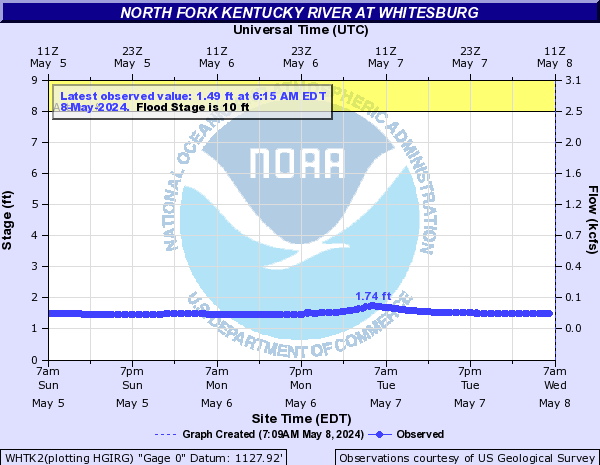
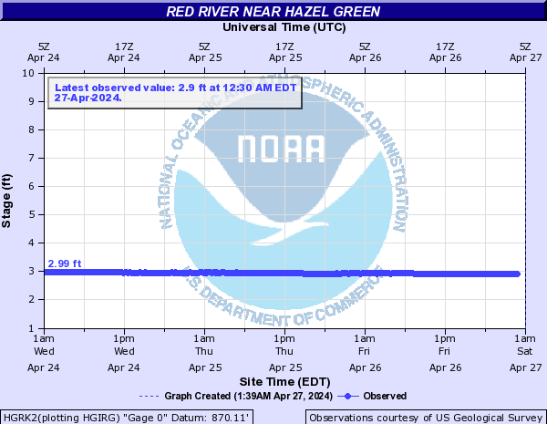
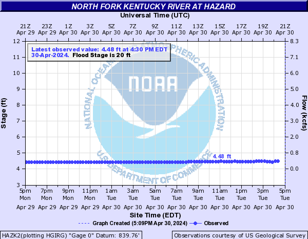
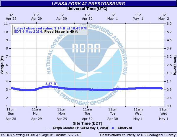
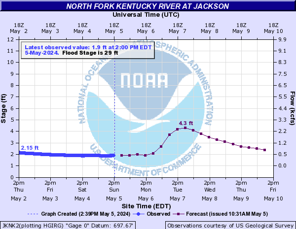
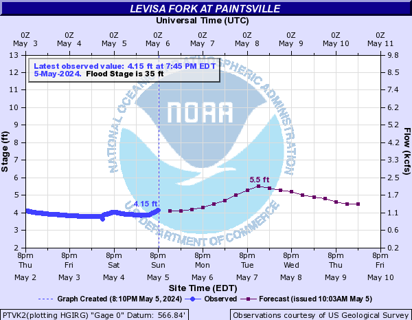
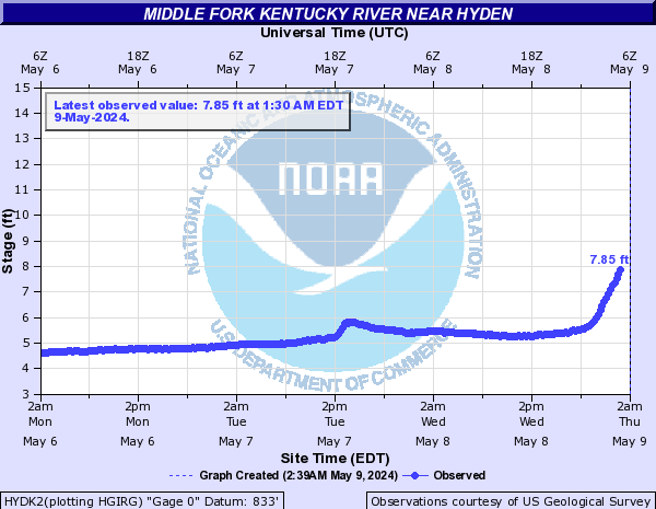
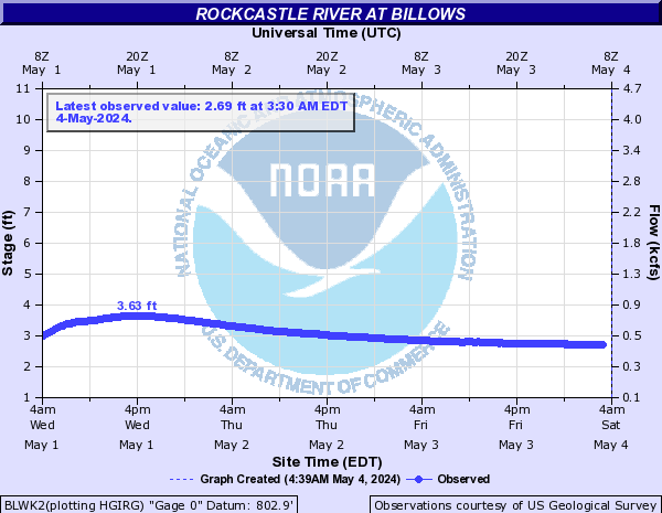
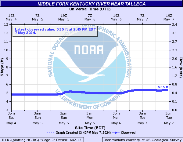
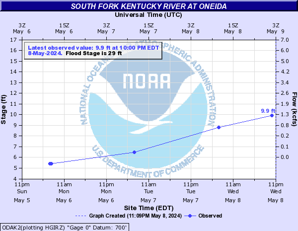
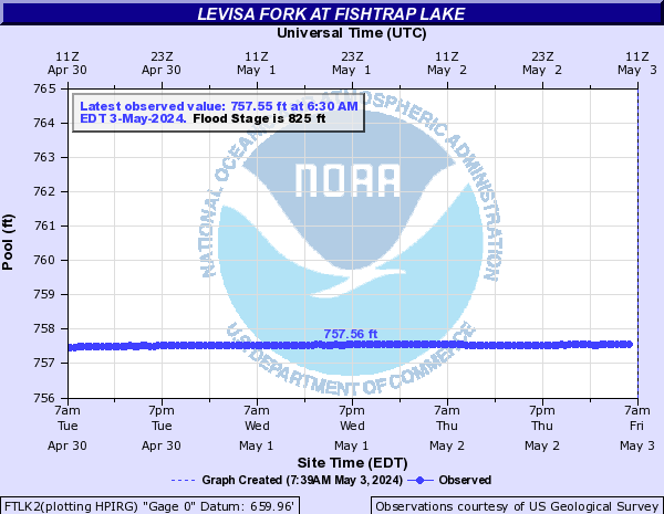
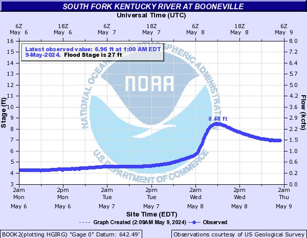
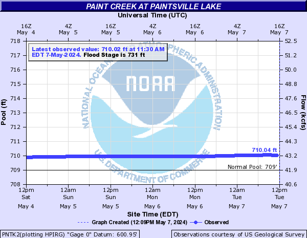
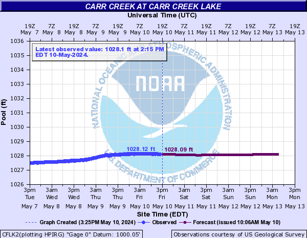
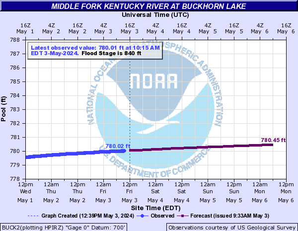
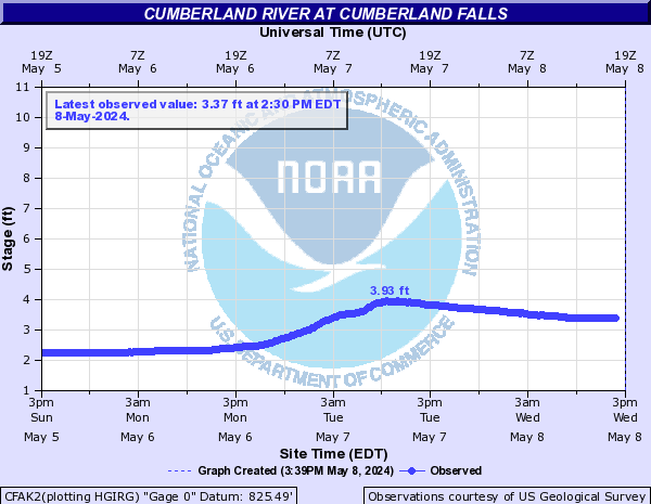
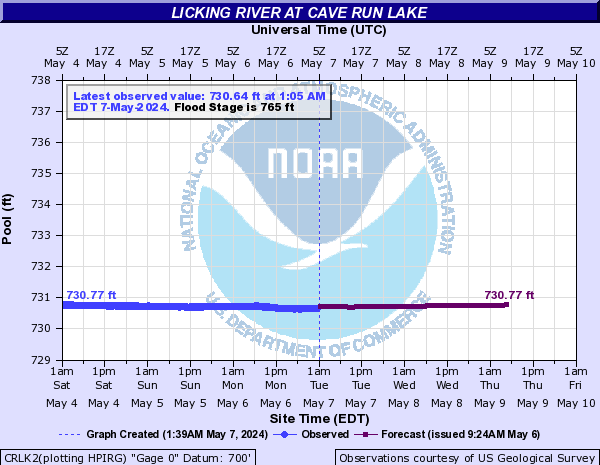
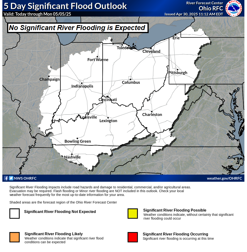
| Rivers/Lakes Quick Glance (click icons to enlarge or click here for more info and additonal locations) | Ohio River Basin Flood Outlook | ||||||||||||||||||||||||||||||||||||||||||||||||||||||||||||||||||||||||||||||
|
 |
||||||||||||||||||||||||||||||||||||||||||||||||||||||||||||||||||||||||||||||
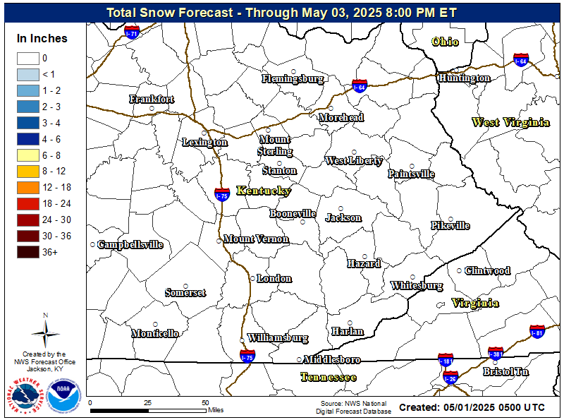
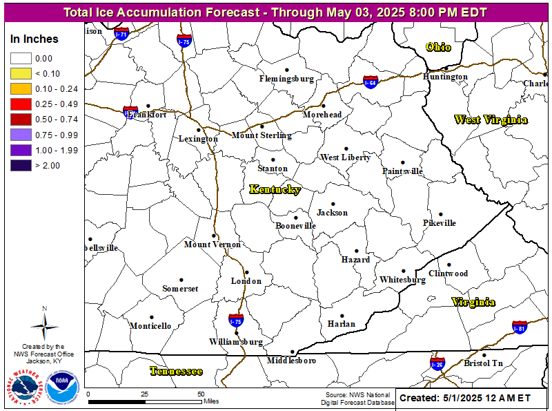
| Local Office Snow & Ice Forecasts | |
 |
 |
| Day 1 Snowfall Greater Than 4" | Day 2 Snowfall Greater Than 4" | Day 3 Snowfall Greater Than 4" |
 |
 |
 |
| Day 1 Freezing Rain Greater than 1/4" | Day 2 Freezing Rain Greater than 1/4" | Day 3 Freezing Rain Greater than 1/4" |
 |
 |
 |
WFAS Observed Fire Danger Rating |
WFAS Forecast Fire Danger Rating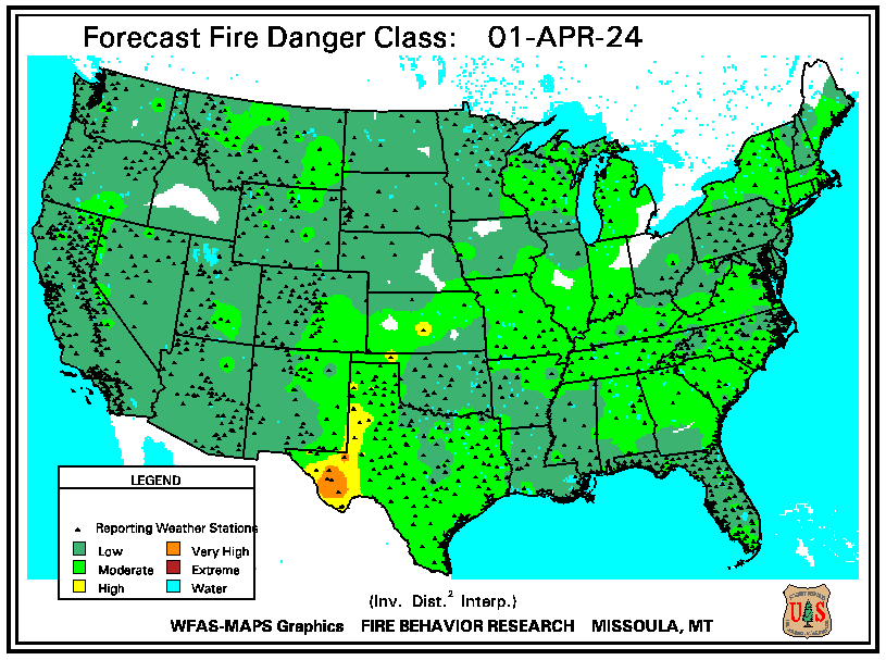 |
| SPC Fire Weather Day 1 Outlook | SPC Fire Weather Day 2 Outlook | SPC Fire Weather Day 3-8 Outlook |
 |
 |
 |
| Drought Monitor | Seasonal Drought Outlook | NICC Significant Fire Potential Outlook |
 |
 |
 |
 |