Scattered strong to severe thunderstorms will persist over the central to southern High Plains this weekend with a severe weather and flash flooding threat. A late season storm will bring low elevation rain and high elevation snow to portions of California, Nevada and Oregon through the weekend. Winter Weather Advisories are in place for the Sierra for snow totals of 3-6", locally higher. Read More >
Read the Area Forecast Discussion (click to open)
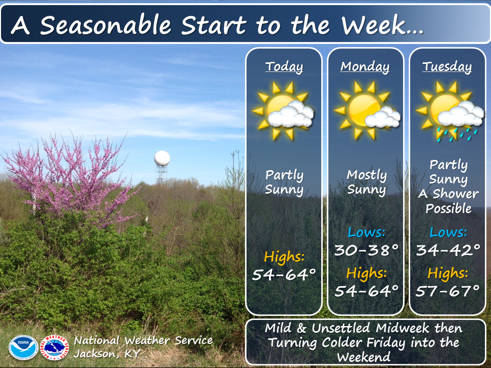
672 FXUS63 KJKL 270559 AFDJKL AREA FORECAST DISCUSSION National Weather Service Jackson KY 159 AM EDT Sun Apr 27 2025 .KEY MESSAGES... - Near to slightly below normal temperatures are in store for the weekend, before above normal readings make a comeback for much of the coming work week. - There is a possibility of frost developing in the sheltered valleys of eastern Kentucky late Sunday night. - The next significant potential for showers and thunderstorms arrives Tuesday and continues at times through Friday. Some storms Tuesday through Thursday could be strong to severe. && .UPDATE... Issued at 159 AM EDT SUN APR 27 2025 Leftover low clouds continue to erode southeast leaving behind some high clouds. Forecast fog extent was increased in valleys through sunrise Sunday while overnight temperatures were fine- tuned. Expect low temperatures of 40-45F in most locations, though some sheltered valleys northeast of US-421 could dip into the upper 30s. UPDATE Issued at 930 PM EDT SAT APR 26 2025 Have tried to fine tune the sky cover forecast as the back edge of a low overcast drops south through eastern Kentucky this evening. Have also made adjustments for cooler valley low temperatures in many places on Monday night. && .SHORT TERM...(This evening through Sunday night) Issued at 311 PM EDT SAT APR 26 2025 Cold front will exit southeastern Kentucky this evening with low clouds gradually scattering out and becoming more limited with time to the windward side of the mountains toward the Virginia border. Surface high pressure and dry air advection may allow for lows late tonight to reach the upper 30s in the typical cold spots in the northeastern parts of the forecast area, with 40s elsewhere. Northwesterly flow aloft continues through Sunday between an upper ridge over the MS Valley and a deep upper trough exiting off the Northeast U.S. coastline. Surface high pressure will remain centered over the Lower Great Lakes. High temperatures will be slightly below normal in the mid-60s north to lower-70s south, with just passing high clouds. Approaching upper ridging, light winds, and mostly clear to partly cloudy skies will set the stage for another chilly night under good radiational cooling conditions, especially in northeastern counties, where frost will be possible. With dew points in the lower to mid 30s forecast, minimum temperatures may fall as low as the mid-30s. Meanwhile, ridgetops may be as warm as the upper 40s to lower 50s. .LONG TERM...(Monday through Saturday) Issued at 311 PM EDT SAT APR 26 2025 Warm advection begins in earnest Monday ahead of a strengthening system over the northern and central U.S., with temperatures returning to above normal readings for highs and lows until the passage of a cold front late in the week around Friday. Dry conditions are expected Monday with the upper ridge axis still west of the area despite low-level southwesterly flow increasing near the surface. However, by Monday night into Tuesday Gulf moisture will start to infiltrate eastern Kentucky bringing a more humid air mass, and with that will come increasing chances for showers and thunderstorms through the daytime hours Tuesday, and then continuing shower and thunderstorm chances through Friday. Along with the increased moisture will come an increase in instability and wind shear as the jet stream strengthens over the area, so we will need to monitor for the potential for severe weather at times by late Tuesday afternoon and lingering into Tuesday night, and possibly again Thursday and Thursday night with the approach of an energetic upper trough and associated cold front. Temperatures cool back toward seasonal normals to end the week behind the passage of the cold front Friday and upper trough bringing northwesterly flow. && .AVIATION...(For the 06Z TAFS through 06Z Sunday night) ISSUED AT 159 AM EDT SUN APR 27 2025 MVFR ceilings continue to erode southeast to along the VA/KY border. All TAF terminals have improved to VFR and are expected to remain so through the forecast period. However, non-TAF lower- elevation terminals such as K1A6 and KCPF could see flight category reductions to IFR or worse from valley fog early this morning. Any fog will dissipate after sunrise, leaving VFR conditions area-wide through the remainder of the TAF period. Winds will be light at around 10 kts or less through Sunday night. && .JKL WATCHES/WARNINGS/ADVISORIES... None. && $$ UPDATE...GEERTSON SHORT TERM...CMC LONG TERM...CMC AVIATION...GEERTSON |
|
|||||||||||||||||||||||