
A Nor'easter will bring significant coastal impacts to the Mid-Atlantic and New England through the weekend. Moderate to major coastal flooding, heavy rain, strong winds and high surf expected. Tropical Storm Nolo will continue to strengthen as it moves north toward the Big Island of Hawaii. Heavy rainfall may bring life-threatening, catastrophic flooding and mudslides through the weekend. Read More >
The National Weather Service utilizes a 3-tiered approach to alerting citizens to the potential for severe thunderstorms and/or tornadoes. The 3 tiers are OUTLOOK, WATCH and WARNING.
 |
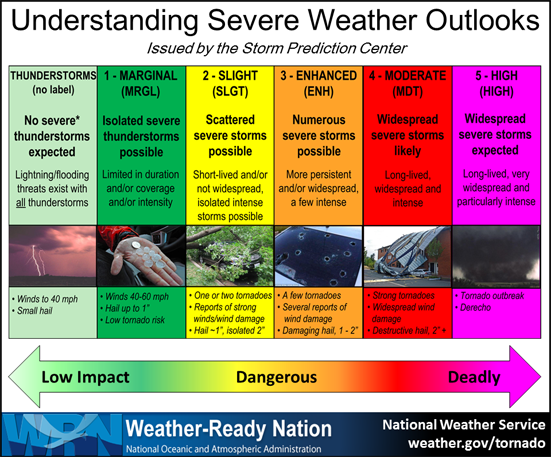
The National Weather Service's Storm Prediction Center, located in Norman, Oklahoma, is constantly looking for severe weather threats up to a week in advance. The Storm Prediction Center issues “Convective Outlooks” detailing areas where severe weather is possible. Your local National Weather Service office then localizes this information for their forecast area. The NWS in Jackson, KY issues a Hazardous Weather Outlook every morning, and more often if needed, detailing the severe weather threats over the next week for most of eastern Kentucky. Both the Storm Prediction Center’s Outlooks and NWS Jackson’s daily Hazardous Weather Outlook can be found at https://www.weather.gov/jkl/dss_outlook.
The following graphic can be used to help you understand the categories found on SPC's Convective Outlooks:
|
|
The latest watches issued by the Storm Prediction Center can be found at http://www.spc.noaa.gov/products/watch/ and will also show up on the map on our website at https://www.weather.gov/jkl/.
 |
It's important to prepare and have a severe weather action plan in place BEFORE severe weather threatens, and then implement that plan and take action quickly when a warning is issued. Visit http://www.nws.noaa.gov/om/severeweather/index.shtml for more information on how to develop your severe weather action plan.




 Follow us on X
 Follow us on Facebook
 Follow us on YouTube
 JKL RSS Feed