Freezing Rain and Sleet
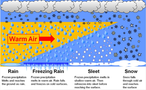
Both freezing rain and sleet occur by the same general process: liquid raindrops in a layer of warm air well above the surface fall into a layer of freezing air hugging the ground. The difference between these two wintry precipitation types depends on the thickness of the layer of freezing air.
Freezing rain occurs when the layer of freezing air is so thin that the raindrops do not have enough time to freeze before reaching the ground. Instead, the water freezes on contact with the surface, creating a coating of ice on whatever the raindrops contact.
Sleet is simply frozen raindrops and occurs when the layer of freezing air along the surface is thicker. This causes the raindrops to freeze before reaching the ground.

Why are Freezing Rain and Sleet Dangerous?
Both of these wintry precipitation types are hazardous for travelers. With either type, the ice can create slick spots on roadways, causing motorists to lose control of their automobiles with little to no warning. Bridges, overpasses and elevated roadways are especially susceptible to icing as they are surrounded on all sides by the cold air and freeze more quickly.
In addition, ice caused by freezing rain can rapidly add weight to tree branches and power lines, causing them to snap or break. In addition to these fallen branches causing damage to whatever they land on, power outages may also occur.
How is Icing Caused by Freezing Rain Measured?
Ice accumulation from freezing rain does not coat the surface of objects evenly. Gravity will usually cause the rain water to run to the underside of an object before it freezes. Wind can create the same effect. In either case, the result would be a thicker coating of ice on one side of the object compared to the opposite side.
You can accurately estimate the thickness of the ice with the method below. You will need a ruler or measuring tape and possibly a piece of paper and pencil.
1. Locate an ice-covered object that is out in the open. A small tree branch in the middle of the yard or clothesline is usually easiest to handle.
2. Move to a position where you can see both the thickest and thinnest portions of ice coating the object from one side to the other.
3. Using the ruler, measure the thickest part of the ice, from the edge of the object to the edge of the ice. Record that value on your paper.
4. Similarly, measure the thinnest part of the ice, from the edge of the object to the edge of the ice. Record that value on your paper.
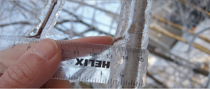
5. Add the two values together and then divide by two. The resulting value is your radial ice accumulation. (In the case below, the radial ice accumulation is 1/4" (or 0.25"), which is the average of 3/16" on the right side of the branch and 5/16" on the left side of the branch.)

6. Convert the radial ice to flat ice accumulation (the type of ice accumulation that is forecast by the NWS) by multiplying the radial ice accumulation by 2.54. The resulting amount should be reported to the NWS. (In the example above, this would be 0.25" radial ice accumulation x 2.54 = 0.64" flat ice accumulation.)
How is Sleet Measured?
Sleet is measured much the same way snow depth is measured. You will need a ruler, and possibly a piece of paper and a pen.
1. Locate a surface that is solid, level and in the open. Avoid measuring sleet depth under trees or directly next to buildings.
2. Slide the ruler directly downward into the sleet until it reaches the ground.
3. Read the value on the ruler to the nearest tenth of an inch, if possible.
4. Record this value on your piece of paper and report to the NWS.
How Do I Report Freezing Rain and Sleet to the National Weather Service (NWS)?
Complete our storm report form.
When making your report, please remember to include the following information, if known: