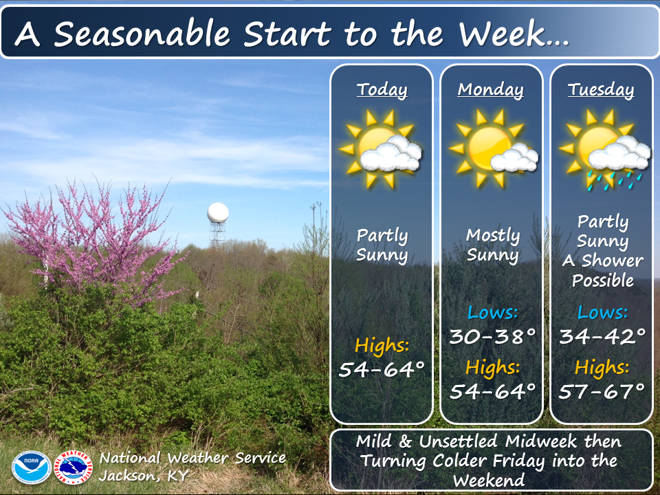
Heavy to excessive rainfall is forecast over north Texas into Oklahoma Tuesday. Locally catastrophic flooding will be possible across portions of southwest Oklahoma. Flood Watches have been issued. Scattered severe thunderstorms are possible within a broad swath from the lower Great Lakes to the southern High Plains Tuesday afternoon into the evening. Read More >
 |
 |
 |
 |
 |
 |
133
WWUS73 KJKL 280800
NPWJKL
URGENT - WEATHER MESSAGE
National Weather Service Jackson KY
400 AM EDT Mon Apr 28 2025
KYZ052-060-104-106>110-119-280900-
/O.CAN.KJKL.FR.Y.0004.000000T0000Z-250428T1300Z/
Rowan-Menifee-Elliott-Morgan-Johnson-Wolfe-Magoffin-Floyd-Martin-
Including the cities of West Liberty, Morehead, Paintsville,
Frenchburg, Sandy Hook, Inez, Wheelwright, Campton, Prestonsburg,
and Salyersville
400 AM EDT Mon Apr 28 2025
...FROST ADVISORY IS CANCELLED...
A late night increase in cloud cover has kept temperatures warmer
than previously forecast. This should prevent frost formation
from occurring early this morning.
$$
GEERTSON
Read the Hazardous Weather Outlook (click to read)
831 FLUS43 KJKL 290742 HWOJKL Hazardous Weather Outlook National Weather Service Jackson KY 342 AM EDT Tue Apr 29 2025 KYZ044-050>052-058>060-068-069-079-080-083>088-104-106>120-300745- Fleming-Montgomery-Bath-Rowan-Estill-Powell-Menifee-Rockcastle- Jackson-Pulaski-Laurel-Wayne-McCreary-Whitley-Knox-Bell-Harlan- Elliott-Morgan-Johnson-Wolfe-Magoffin-Floyd-Lee-Breathitt-Knott- Owsley-Perry-Clay-Leslie-Letcher-Martin-Pike- 342 AM EDT Tue Apr 29 2025 This Hazardous Weather Outlook is for a portion of eastern Kentucky. .DAY ONE...Today and tonight. Thunderstorms are possible at times from this afternoon into tonight. Some of the thunderstorms may be strong to severe, especially during the late afternoon and evening hours. Strong to damaging winds and heavy rainfall are the primary threats. However, hail or a brief spin up tornado cannot be ruled out. .DAYS TWO THROUGH SEVEN...Wednesday through Monday. Thunderstorms are possible at times from Wednesday to early on Saturday. Some of the thunderstorms on Thursday could be strong, with gusty winds and heavy rainfall the primary threats. .SPOTTER INFORMATION STATEMENT... Spotters are encourage to report any instances of strong winds, hail, and heavy rain. $$ JP
Read the Area Forecast Discussion (click to read)
031 FXUS63 KJKL 290618 AAC AFDJKL AREA FORECAST DISCUSSION...UPDATED National Weather Service Jackson KY 218 AM EDT Tue Apr 29 2025 .KEY MESSAGES... - Above normal temperatures will persist through the work week, followed by below normal temperatures next weekend. - The next significant potential for showers and thunderstorms arrives Tuesday afternoon and continues at times through Friday. Some storms, especially on Tuesday and Thursday, could be on the strong side. && .UPDATE... Issued at 200 AM EDT TUE APR 29 2025 With the gradient increasing between a departing ridge of sfc high pressure centered off the mid Atlantic coast and a low pressure system tracking into the Great Lakes and a trailing cold front into IA to eastern KS to the TX and OK panhandles vicinity to the Four Corners region, winds aloft have increased. This has led to some gustiness or mixiness, especially for more open terrain locations and some coalfield ridges as well as some locations downwind of Cumberland Mountain and perhaps downwind of Pine and Black Mountains as well near the VA border. The temperature at K1A6 has bounced around accordingly recently reported at 71 following a reading of 64 an hour and a half ago. Overall with mixiness expected to linger for the duration of the overnight, this leads to uncertainty in hourly temperatures as well as min T for the more open terrain locations as well as coalfield ridges and some areas immediately downwind of the VA border. Meanwhile, the more sheltered/ protected valley locations should continue experiencing temperatures falling to the low to mid 50s. Overall, hourly grids were freshened up based on recent observations and trends. UPDATE Issued at 1053 PM EDT MON APR 28 2025 Late evening temperatures have been blended into the forecast without any substantive changes. UPDATE Issued at 934 PM EDT MON APR 28 2025 Temperatures in eastern valleys have dropped off quickly this evening, and adjustments have been made for the more rapid fall. This includes also nudging morning minimums down slightly. Low level flow will be increasing during the night which will hinder western valleys from decoupling. As is usual in this scenario, the most questionable forecast is in between these two areas, and to what extent those valleys mix or decouple. && .SHORT TERM...(This evening through Tuesday night) Issued at 300 PM EDT MON APR 28 2025 Warm advection and sunny to mostly sunny skies has resulted in temperatures returning to above normal levels, as upper ridging resides to our immediate west over the TN and Lower Ohio River valleys. The mid-level ridge axis moves across eastern Kentucky overnight and exits east through the day Tuesday. Good radiational cooling at least through the first part of the night will result in temperatures in the deeper valleys falling into the mid-50s, but ridgetops and exposed locations will remain warmer in the lower 60s. Southwest flow will advect increasing humidity and instability into the area through the day Tuesday, with a mid- level disturbance arriving in the afternoon and likely firing off scattered showers and thunderstorms. This will be followed by additional clusters of showers and thunderstorms through the evening into the overnight. There will be sufficient shear for some storms to be on the stronger side in the late afternoon and evening, especially north of the KY Highway 80 corridor in southeast Kentucky. Thunderstorm activity should gradually wind down Tuesday night as a transitory shortwave ridge moves over the area and mid-level winds diminish. Temperatures will remain quite warm for late April, as the associated cold front will stall over the Ohio River Valley, keeping eastern Kentucky within the warm sector. .LONG TERM...(Wednesday through Monday) Issued at 300 PM EDT MON APR 28 2025 Showers and thunderstorms continue at times Wednesday through Friday, with a relative lull late Wednesday into early Thursday as an upper trough lifts out of TX toward the Ohio River Valley, with downstream ridging resulting in increasing heights during that time. Mid-level winds appear to be too weak to support any appreciable severe weather threat Wednesday through Wednesday night. Shear and instability increase through the day Thursday, which will likely support at least a marginal threat for a few stronger storms, as several rounds of showers and thunderstorms are expected Thursday afternoon through Thursday night, with a cold frontal passage the first half of Friday bringing a cooler air mass to eastern Kentucky to end the week. However, even behind the cold front Friday showers and possibly a few storms will linger into the evening as an amplified upper trough passes across eastern Kentucky. A cooler and drier air mass moves over the area for the weekend, with high temperatures falling below normal in the 60s Saturday and returning closer to normal in the 70s Sunday. Saturday and Sunday night lows will also be on the cool side, especially in sheltered valleys where mid to upper 30s may be possible Saturday night, followed by lows around 40 degrees Sunday night. && .AVIATION...(For the 06Z TAFS through 06Z Tuesday night) ISSUED AT 215 AM EDT TUE APR 29 2025 VFR was reported at issuance time and VFR should generally prevail in all locations through at least 18Z. With winds just off the surface having increased just off the surface with an increasing gradient between departing high pressure and a cold front well to the west, LLWS will be concern through around 12Z to 13Z. This will mainly affect locations along or north of a line from KLOZ to KJKL to KSJS. Otherwise, with daytime heating on Tuesday, wind gusts from the south to southwest should pick up into the 15 to 20K range between about 11Z and 15Z, before winds slacken toward 00Z. As the front approaches from the west, chances for showers and thunderstorms increase generally after 18Z, initially at KSYM among the TAF SITES. Chances will increase further southeast at KSME, KLOZ, KJKL, and KSJS through about 00Z and remain in place through the end of the period. Any thunderstorms would bring temporary and localized IFR or worse conditions along with the potential for wind gusts to 30KT or higher. && .JKL WATCHES/WARNINGS/ADVISORIES... None. && $$ UPDATE...JP SHORT TERM...CMC LONG TERM...CMC AVIATION...JP |
||||||||||||||