
High winds and very dry conditions will continue to produce elevated to critical fire weather conditions over portions of New Mexico and far western Texas through Saturday. Heavy snow will continue in the Central Rockies Heavy rain, flooding, and severe thunderstorm risks increase from the Southern Plains into the Lower Missouri Valley this weekend. Read More >
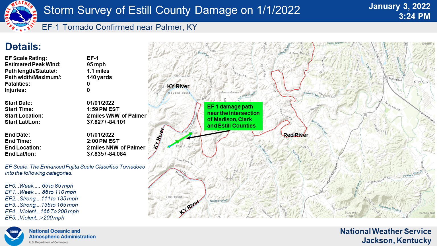
Public Information Statement
National Weather Service Jackson KY
234 PM EST Mon Jan 3 2022

...NWS Damage Survey for 01/01/2022 Tornado Event...

.Estill County Kentucky Tornado...

EF Scale Rating:           EF-1
Estimated Peak Wind:       95 mph
Path length/Statute/:      1.1 miles
Path width/Maximum/:       140 yards
Fatalities:                0
Injuries:                  0

Start Date:                01/01/2022
Start Time:                1:59 PM EST
Start Location:            2 miles WNW of Palmer
Start Lat/Lon:             37.827 / -84.101

End Date:                  01/01/2022
End Time:                  2:00 PM EST
End Location:              2 miles NNW of Palmer
End Lat/lon:               37.835 / -84.084

Survey Summary:

NWS storm survey team found damage that was the result of an
EF-1 tornado with maximum wind speeds estimated at 95 mph.
Numerous trees were snapped or uprooted, a barn was collapsed,
and the roof of an auto repair facility was damaged.

The tornado touched down along Thornburg Bend, where trees were
snapped. A barn was collapsed at a farm off of Harris Perry Road,
and an auto repair facility on Red River Road lost part of its
roof. Multiple downed trees blocked access to the dead end of Red
River Road. The tornado lifted just west of the Red River.

The National Weather Service Jackson thanks National Weather
Service Louisville, Estill County Emergency Management, and
Kentucky Emergency Management for their assistance with the storm
survey.

EF Scale: The Enhanced Fujita Scale Classifies Tornadoes into the
following categories.

EF0...Weak......65 to 85 mph
EF1...Weak......86 to 110 mph
EF2...Strong....111 to 135 mph
EF3...Strong....136 to 165 mph
EF4...Violent...166 To 200 mph
EF5...Violent...>200 mph

Note: The information in this statement is preliminary and subject
to change pending final review of the event and publication in
NWS Storm Data.

