
High winds and very dry conditions will continue to produce elevated to critical fire weather conditions over portions of New Mexico and far western Texas through Saturday. Heavy snow will continue in the Central Rockies Heavy rain, flooding, and severe thunderstorm risks increase from the Southern Plains into the Lower Missouri Valley this weekend. Read More >
A cold front and an upper level disturbance initially brought a round of light snow from late on the evening of Thursday 1/27/2022 into the morning of Friday 1/28/2022. During the afternoon and evening, colder air moved into the region while moisture remained in place, leading to snow showers and some heavier snow squalls with these lingering into the predawn hours of Saturday 1/29/2022. Most locations picked up light to moderate amounts of snowfall, although a persistent band of snow showers enhanced by upslope northwest to north winds affected far western Letcher County and eastern Harlan County. Totals around 6 inches were reported in the Cumberland and Lynch vicinity, with amounts near 9 inches reported near the VA state line along KY 160 at 3700 feet in the Big Black Mountain area. Image 1 below contains estimated snowfall from this event, while a table below Image 1 contains snowfall reports from around the region.
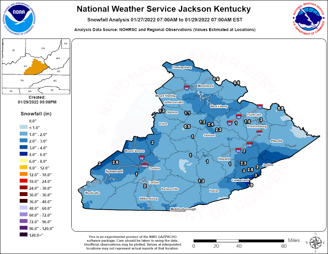
Image 1: Estimated Snowfall Analysis based on NOHRSC data and reports received from across the region.
NOUS43 KJKL 292120
PNSJKL
KYZ044-050>052-058>060-068-069-079-080-083>088-104-106>120-300920-

Public Information Statement
National Weather Service Jackson KY
420 PM EST Sat Jan 29 2022

...SNOWFALL REPORTS...

Location                     Amount    Time/Date       Lat/Lon

...Kentucky...

...Bell County...
1 NNW Beverly                1.3 in    1100 PM 01/28   36.94N/83.54W

...Breathitt County...
Campton 9.3 SE               2.4 in    0700 AM 01/29   37.66N/83.41W
NWS Office/Julian Carroll Ai 2.3 in    0700 AM 01/29   37.59N/83.31W
Dumont                       1.6 in    0750 AM 01/29   37.53N/83.36W
Inverness                    1.5 in    1000 PM 01/28   37.53N/83.36W

...Clay County...
Oneida                       1.0 in    0800 AM 01/29   37.27N/83.65W

...Elliott County...
Olive Hill 9.0 SSE           0.5 in    0900 AM 01/29   38.19N/83.08W

...Estill County...
Cressy                       1.3 in    0800 AM 01/29   37.83N/84.03W

...Fleming County...
Ewing 1.9 ESE                0.2 in    0700 AM 01/29   38.42N/83.83W

...Floyd County...
1 E Bays Branch              3.0 in    0800 AM 01/29   37.72N/82.75W
Prestonsburg 3 WSW           2.1 in    0700 AM 01/29   37.66N/82.83W
Emma                         2.0 in    0850 PM 01/28   37.64N/82.70W
2 ESE Ivyton                 1.5 in    0735 PM 01/28   37.69N/82.94W
Prestonsburg                 1.0 in    1146 AM 01/29   37.67N/82.77W

...Harlan County...
1 E Big Black Mountain       9.0 in    0800 AM 01/29   36.91N/82.87W
Lynch                        6.5 in    1037 AM 01/29   36.96N/82.91W
1 SSW Cumberland             6.0 in    0800 AM 01/29   36.98N/82.99W
Fresh Meadows                3.5 in    0800 AM 01/29   36.84N/83.37W

...Jackson County...
McKee 8.3 W                  3.0 in    0800 AM 01/29   37.43N/84.14W

...Johnson County...
Paintsville 1 E              2.0 in    0700 AM 01/29   37.82N/82.78W

...Knott County...
2 SE Hindman                 2.0 in    0945 PM 01/28   37.32N/82.96W

...Knox County...
Yeager                       0.8 in    1035 PM 01/28   36.88N/83.83W

...Lee County...
Beattyville 4n               0.5 in    0900 AM 01/29   37.63N/83.72W

...Leslie County...
Thousandsticks               1.0 in    0848 AM 01/29   37.19N/83.43W

...Letcher County...
Skyline                      3.0 in    0700 AM 01/29   37.07N/82.97W
1 N Oven Fork                3.0 in    0800 AM 01/29   37.07N/82.81W
Whitesburg 2 SE              2.5 in    0700 AM 01/29   37.10N/82.80W
1 SW Carcassonne             2.3 in    1000 PM 01/28   37.16N/83.00W
1 WSW Day                    2.2 in    0958 PM 01/28   37.07N/82.86W
Ermine                       2.0 in    0800 AM 01/29   37.12N/82.79W

...Magoffin County...
Salyersville                 1.0 in    0800 AM 01/29   37.74N/83.07W

...Martin County...
Inez 2 E                     0.8 in    0700 AM 01/29   37.87N/82.52W

...Montgomery County...
1 S Oggs Station             1.6 in    1000 PM 01/28   38.01N/83.82W

...Owsley County...
Booneville 3.6 ENE           1.0 in    0700 AM 01/29   37.50N/83.62W

...Perry County...
Viper 0.5 N                  1.0 in    0800 AM 01/29   37.19N/83.15W

...Powell County...
Stanton 2 W                  1.6 in    0800 AM 01/29   37.86N/83.90W
1 SSE Nada                   1.1 in    1000 PM 01/28   37.81N/83.71W

...Pulaski County...
1 ENE Magnum                 3.0 in    1040 PM 01/28   37.16N/84.82W
Science Hill                 2.6 in    1030 PM 01/28   37.18N/84.64W
1 NNE Somerset               2.5 in    1020 PM 01/28   37.09N/84.60W
Somerset 15.2 ESE            1.0 in    0700 AM 01/29   37.02N/84.34W

...Rockcastle County...
1 SSE Mount Vernon           2.8 in    1017 AM 01/29   37.35N/84.34W

...Rowan County...
Morehead 6.4 NE              0.6 in    0658 AM 01/29   38.24N/83.34W

...Whitley County...
1 NE Williamsburg            3.0 in    0139 AM 01/29   36.75N/84.16W
Corbin 7.3 SW                2.0 in    0700 AM 01/29   36.87N/84.21W

...Wolfe County...
1 NNE Hollonville            1.2 in    0955 PM 01/28   37.69N/83.45W

