Overview
|
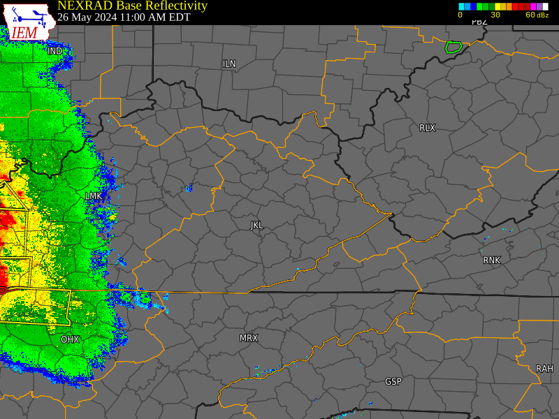
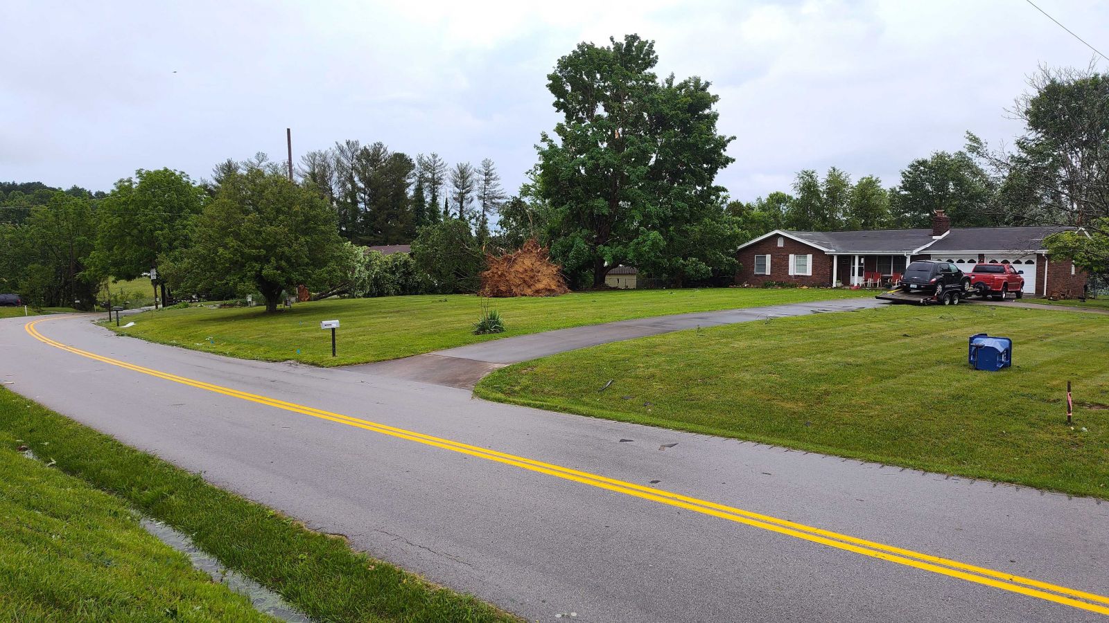
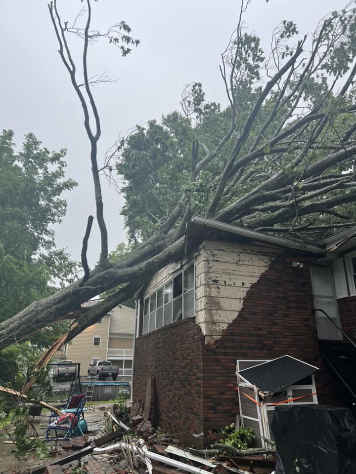
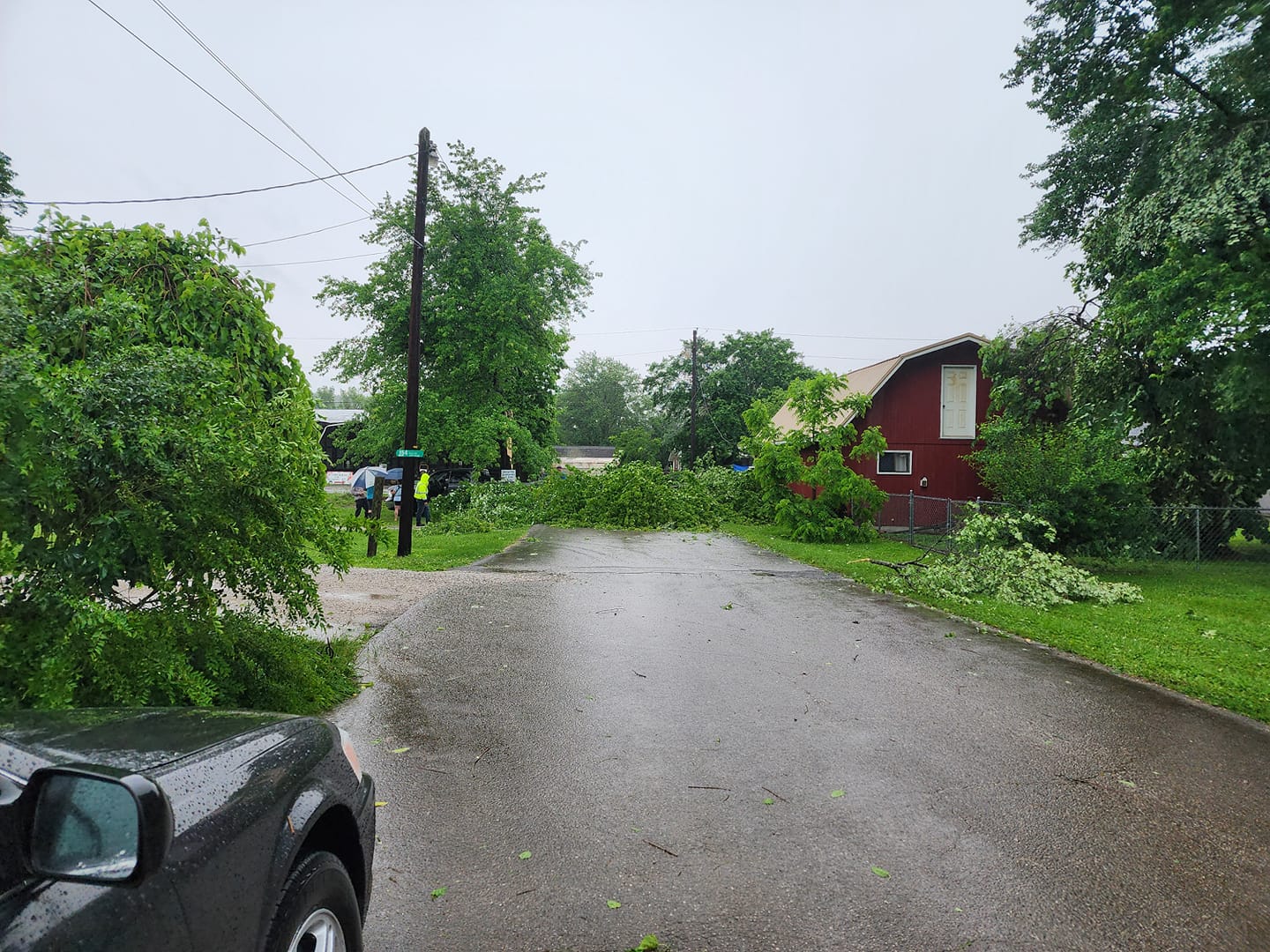
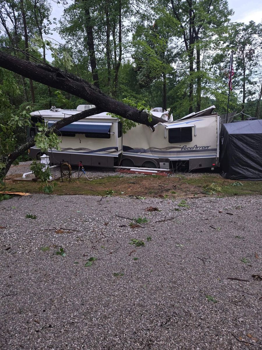
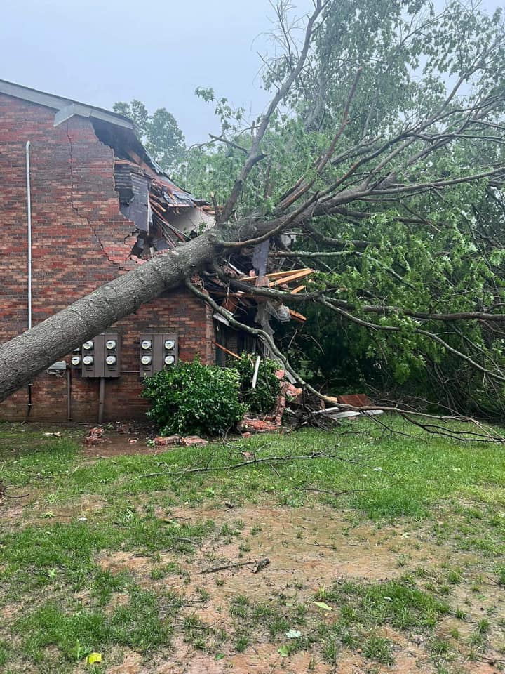
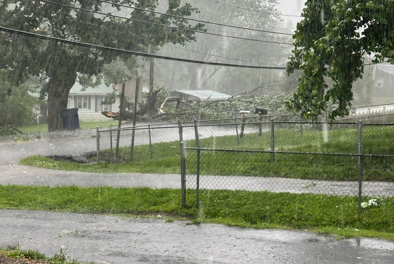
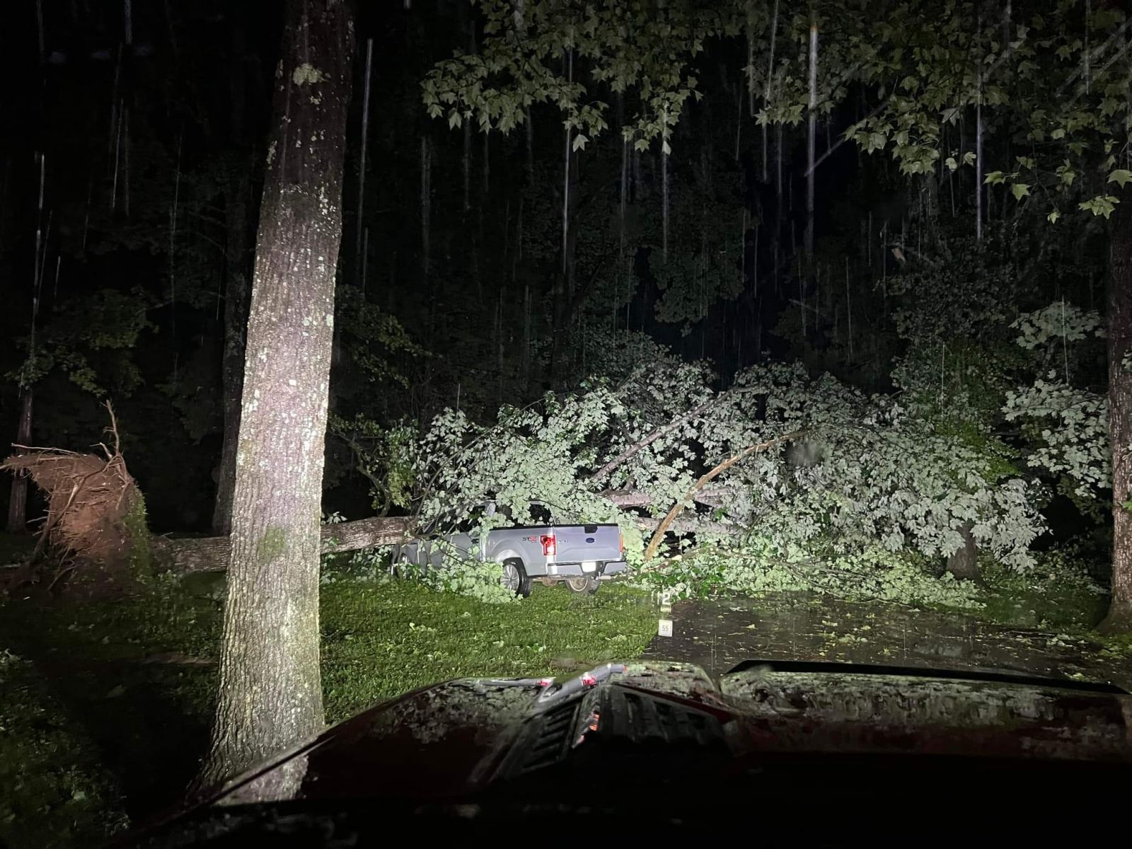
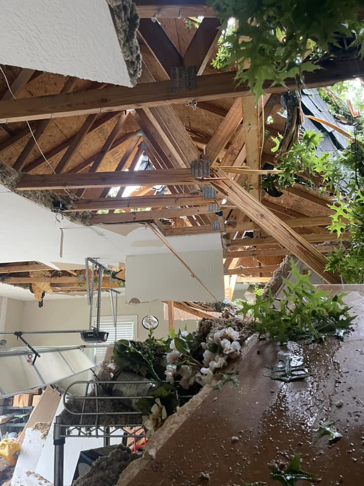
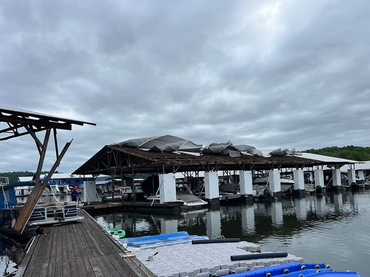
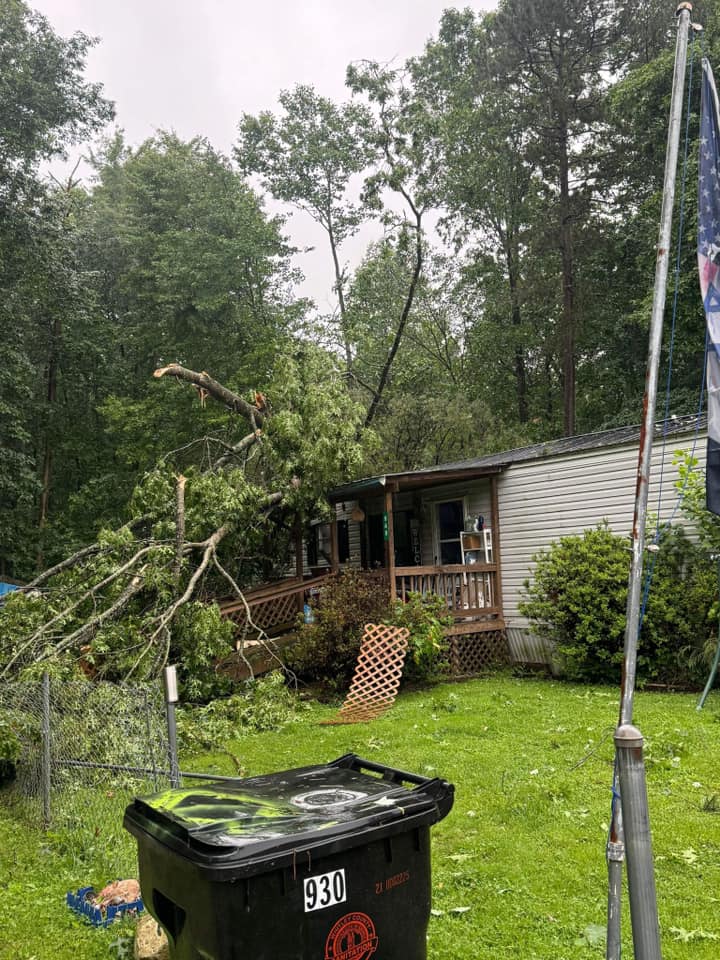
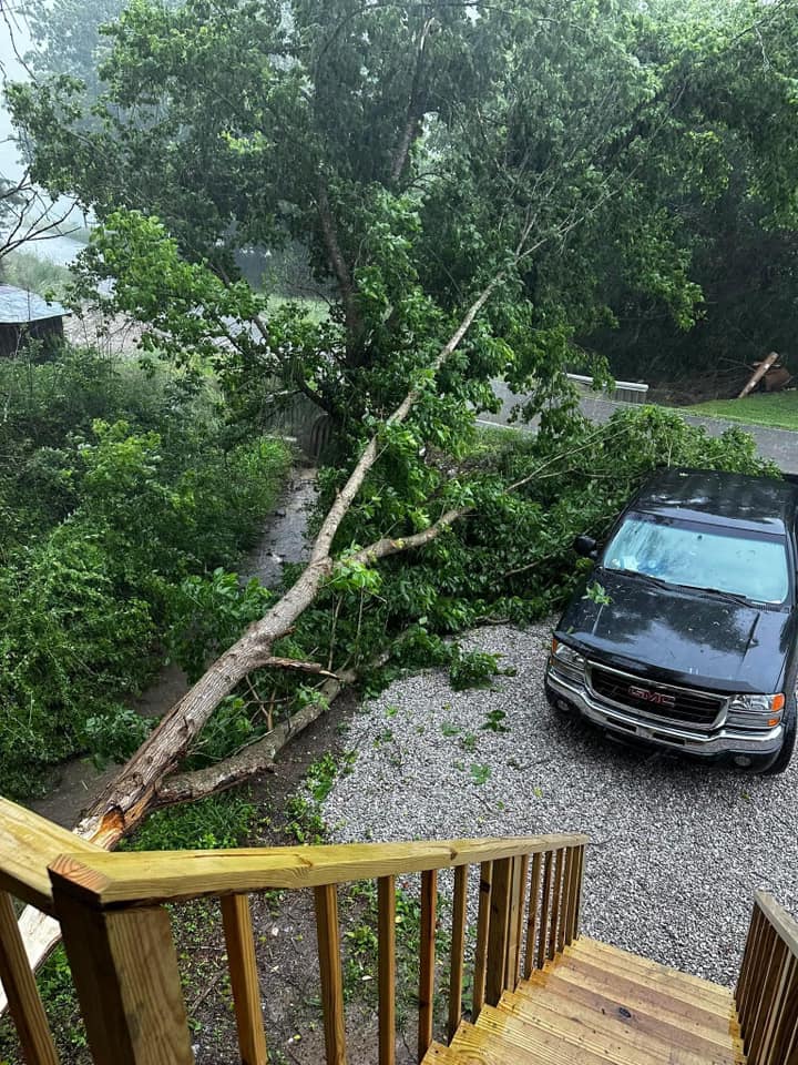
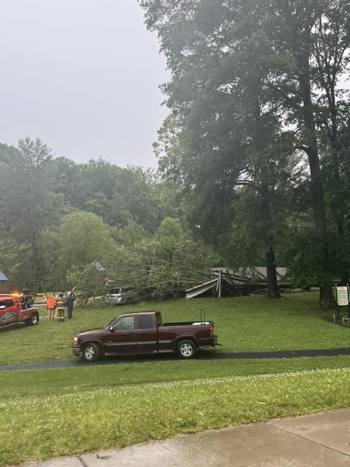
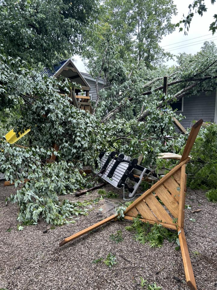
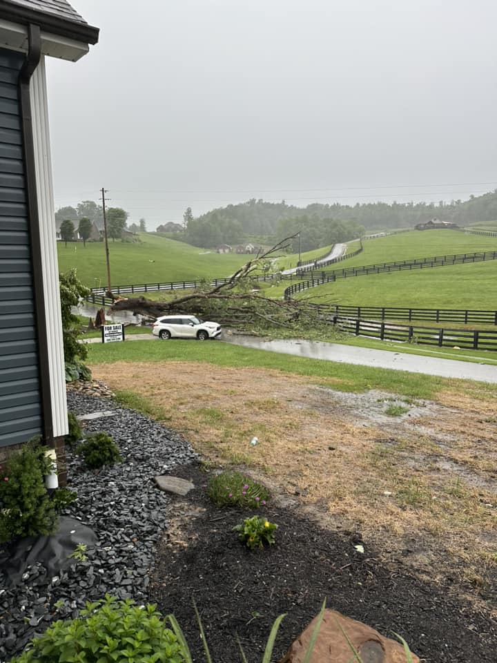
Thunderstorms fired off over the Central Plains on Saturday evening, May 25th, then quickly organized into a line of severe storms (known as a Quasi-Linear Convective System or QLCS) and began a rapid trek eastward, all the while producing damaging wind gusts. This QLCS crossed the mid-Mississippi Valley during the early morning hours on Sunday and quickly pressed eastward across the Commonwealth, reaching eastern Kentucky by early afternoon. Ahead of the line, sufficient daytime heating occurred leading to the buildup of moderate instability. Meanwhile, a dry layer aloft, aided in creating an environment highly favorable for the generation of damaging straight line thunderstorms wind gusts. The thunderstorm line reaching the Lake Cumberland area just after midday, quickly reached the I-75 corridor shortly thereafter and continued to race through the remainder of eastern Kentucky during the afternoon. The highest wind gusts and greatest damage were observed near and south the Hal Rogers Parkway/Kentucky-80 corridor. The highest observed wind gust was 60 mph at the London-Corbin Airport at 1:51 PM. Several other gusts between 50 and 60 mph were also observed in the aforementioned corridor, though embedded elements with much higher gusts almost certainly occurred between weather observation stations. A NWS storm survey team estimated sporadic wind gusts up to 80 mph along this line of storms from central Whitley into far western Knox County where a brief, spin up tornado occurred on the east side of Corbin, near the Siler community. Those storms continued to progress east northeast and produce numerous instances of downed trees and power lines, including several instances of trees falling onto homes and other structures. One person sustained minor injuries in Clay County when they became entrapped within a collapsed structure after the storms. By the time, the first line of storms cleared eastern Kentucky late in the afternoon, tens of thousands of electricity customers had lost their power. Another area of showers and storms followed closely behind the first line but was nowhere near as strong since much of the instability had already been depleted by the prior QLCS. Several hours of quiet conditions followed through the evening before another QLCS, which had developed over Missouri earlier in the day, dove across the Commonwealth overnight. As this third line of storms approached, it began to weaken due to limited instability recovery. Even so, several instances of wind damage were observed during the wee morning hours of the 27th, most notably at the Conley Bottom Resort on Lake Cumberland where local emergency management reported a covered dock collapse, leaving 3 individual entrapped while also damaging many boats. There were also instances of large downed trees at the resort impacting campers and vehicles. In the wake of these storms, power crews worked tirelessly to fix damaging power lines and power poles. Even so, the last power outages lingered into May 30th. |
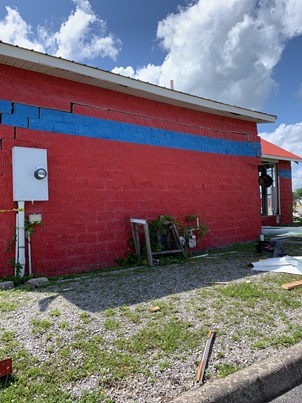
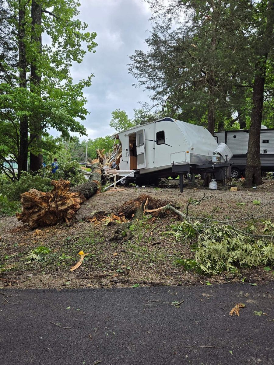 RV Destroyed by Fallen Tree in Wayne County (Courtesy of Wayne County Emergency Management) |
Siler Tornado
|
Tornado - Siler
Track Map 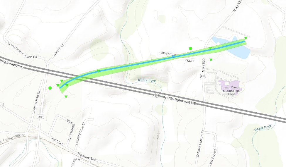 
|
||||||||||||||||
The Enhanced Fujita (EF) Scale classifies tornadoes into the following categories:
| EF0 Weak 65-85 mph |
EF1 Moderate 86-110 mph |
EF2 Significant 111-135 mph |
EF3 Severe 136-165 mph |
EF4 Extreme 166-200 mph |
EF5 Catastrophic 200+ mph |
 |
|||||
 |
 |
 |
| Billboard Blown Down near Beginning of Tornado (Courtesy of Dora Jones) |
Another View of Downed Billboard (Courtesy of NWS Storm Survey) |
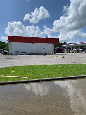
Wind Damage at Convenience Store near Beginning of Tornado (Courtesy of NWS Storm Survey) |
 |
 |
 |
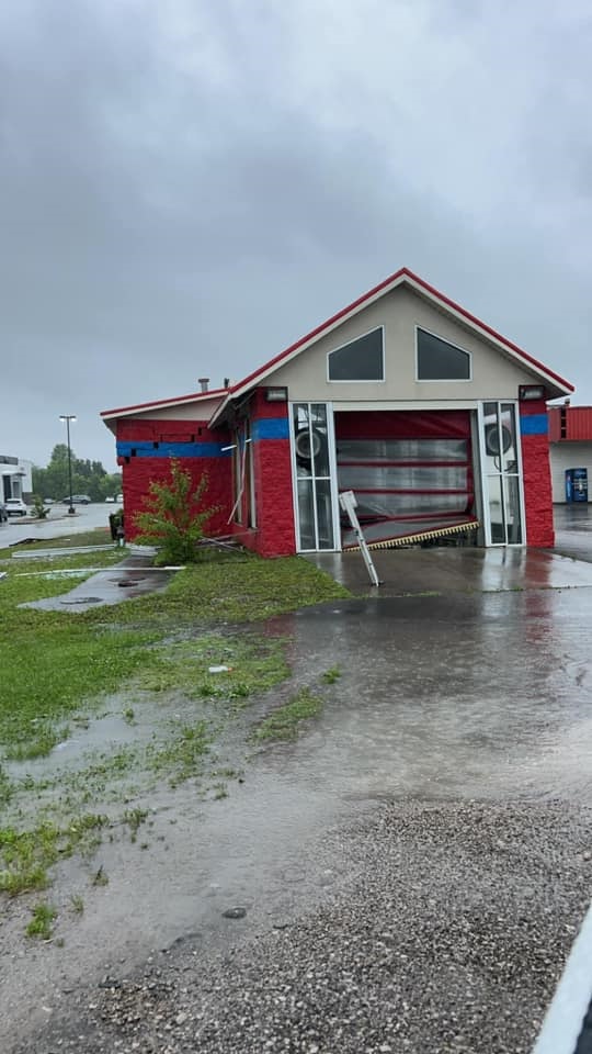
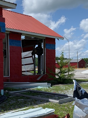
| Tornado-damaged Car Wash (Courtesy of Dora Jones) |
Windows Blown out of Car Wash Building (Courtesy of NWS Storm Survey) |
Cracked East Wall of Car Wash Building (Courtesy of NWS Storm Survey) |
 |
 |
 |
 |
 |
 |
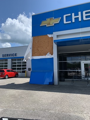
| Damage to Legacy Chevrolet Building ( |
Pickup Truck Fuel Cap Torn Away (Courtesy of NWS Storm Survey) |
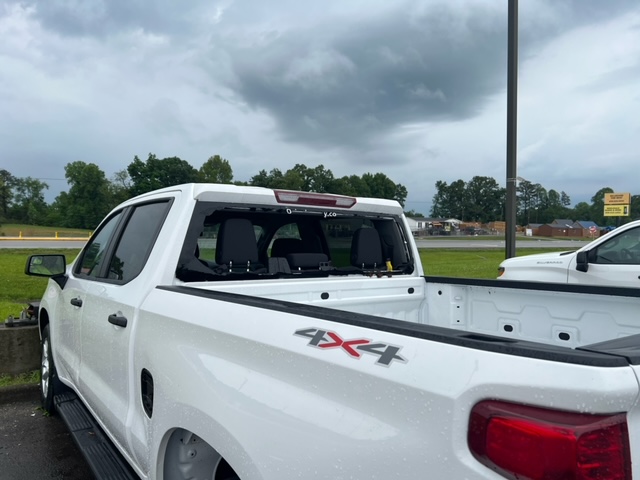
Window Blown out of a Pickup Truck in Dealership Lot (Courtesy of Melissa Jenkins) |
Another Window Blown out of Pickup Truck in Dealership Lot (Courtesy of Devin Frederick) |
Light Pole Blown Down in Front of Dealership (Courtesy of NWS Storm Survey) |
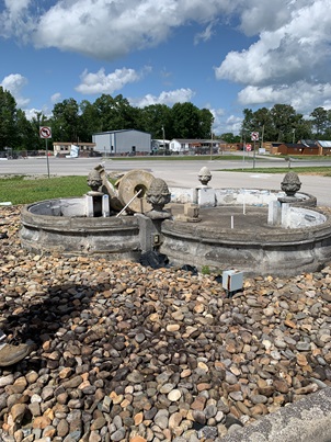
Fountain Knocked Down in Front of Dealership ( |
 |
 |
 |
 |
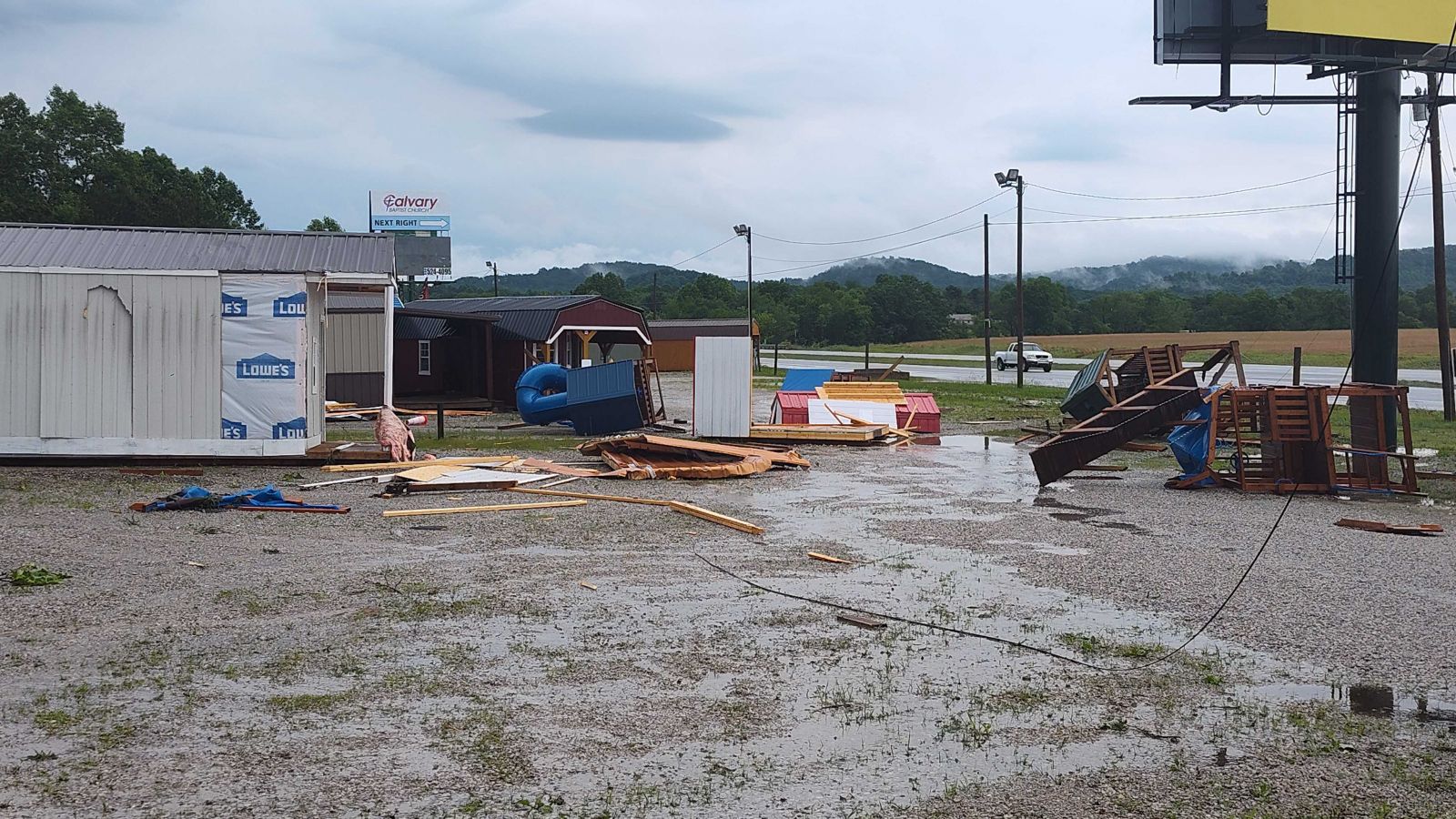 |
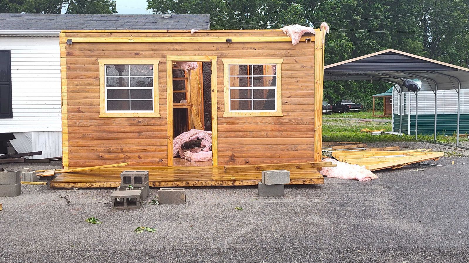
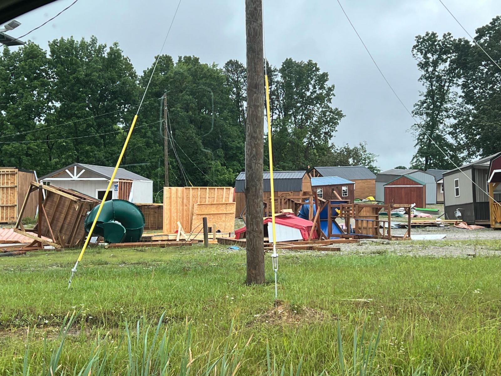
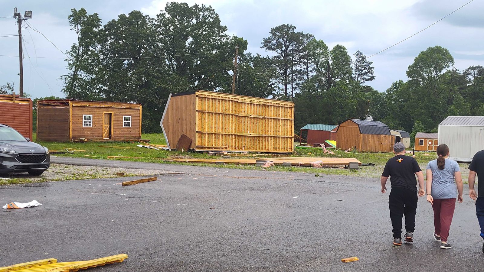
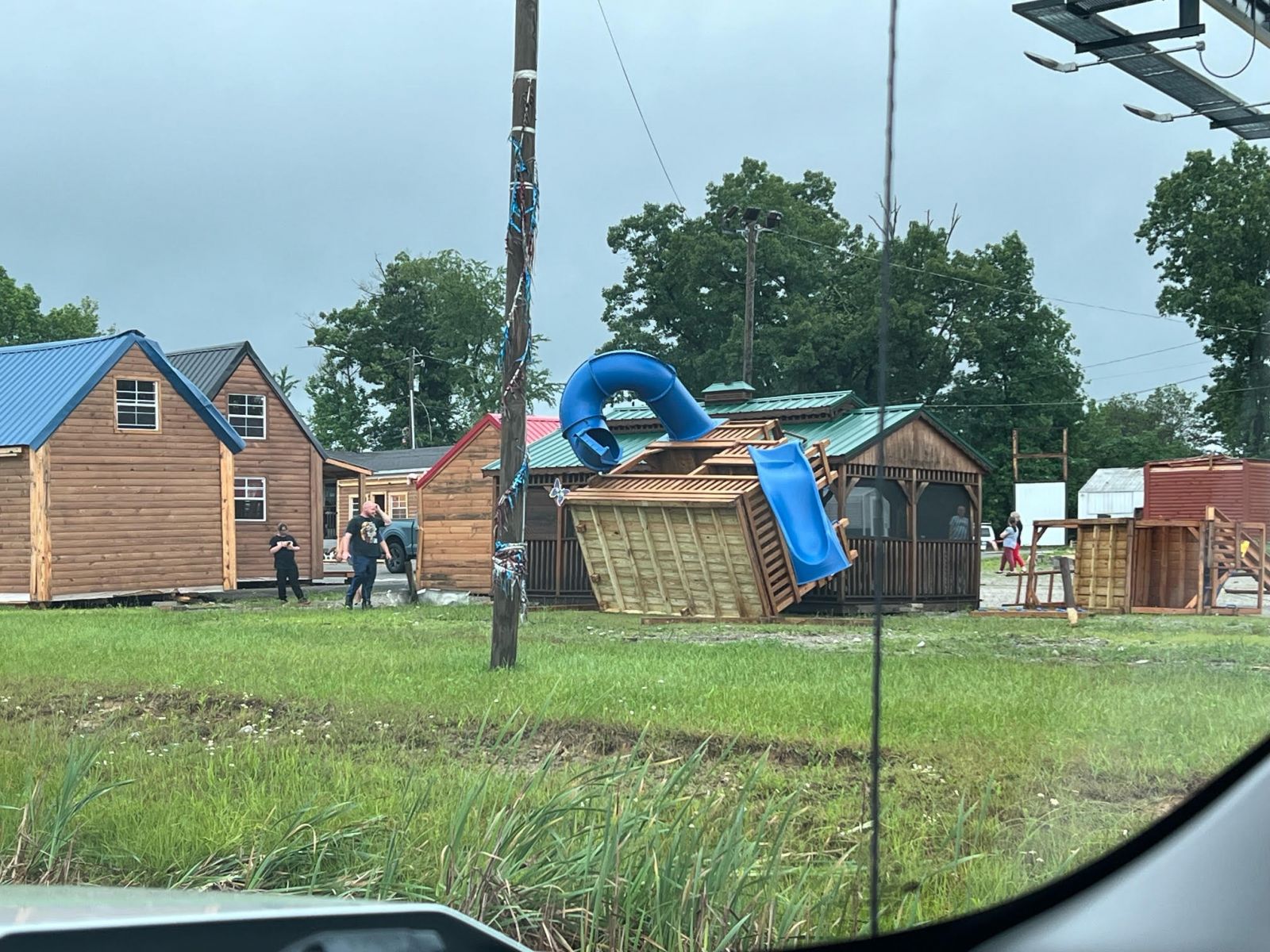
| Damage Building in Manufactured Shed Lot (Courtesy of Shawn Cowden) |
Damage in Manufactured Shed Lot (Courtesy of Devin Frederick) |
Flipped Building Manufactured Shed Lot (Courtesy of Shawn Cowden) |
Playset Damage in Manufactured Shed Lot (Courtesy of Devin Frederick) |
Debris in Manufactured Shed Lot (Courtesy of Shawn Cowden) |
 |
 |
 |
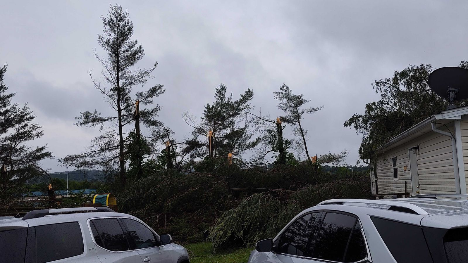
| Row of Snapped Trees near Poplar Grove Road (Courtesy of Shawn Cowden) |
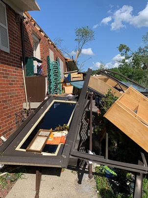
Destroyed Porch near terminus of Tornado Path (Courtesy of NWS Storm Survey) |
Converging Tree Damage along Poplar Grove Road. (Courtesy of Shawn Cowden) |
Straightline Wind Damage
 |
 |
 |
 |
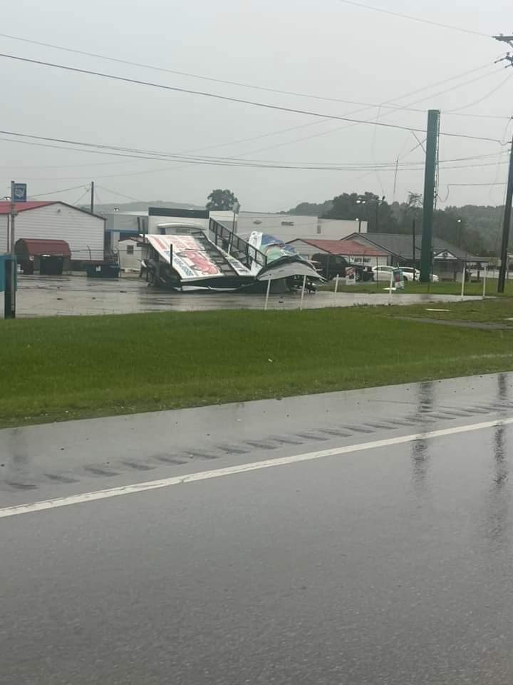
| Roof Blown off Flea Land Flea Market in London (Laurel County) (Courtesy of Bev Stamper) |
Tree on Home in Somerset (Pulaski County) (Courtesy of Pamela Baker Thomsen) |
Tree Damage in Woodbine community (Whitley County) (Courtesy of Emily Rose Whittle) |
Tree on RV (Wayne County) (Courtesy of Wayne County EM) |
 |
 |
 |
 |
| Tree on Apartment Building (Clay County) (Courtesy of Angie Couch) |
Collapsed Floating Boat Dock (Wayne County) (Courtesy of Wayne County EM) |
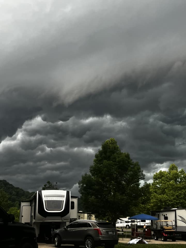
Storm clouds near Paintsville Lake (Johnson County) (Courtesy of Terry and Katrina Conley) |
Tree Down in Middlesboro (Bell County) (Courtesy of WRIL) |
 |
 |
 |
 |
| Tree on Pickup Truck (Wayne County) (Courtesy of Wayne County EM) |
Tree on Home in London (Laurel County) (Courtesy of Gina Gilliam Eddie Vaugh) |
Wind Damage at Conley Bottom Marina (Wayne County) (Courtesy of Wayne County EM) |
Trees on Home in Corbin Area (Whitley County) (Courtesy of Ollie Bryanna Walker) |
 |
 |
 |
 |
| Tree Blown Down Beside Pickup (Owsley County) (Courtesy of Katie Deaton) |
Trees on Park Shelter (Clay County) (Courtesy of Ashley Rickett) |
Tree Damage by House near Gray (Knox County) (Courtesy of Janie Keith) |
Tree Blown Down on Road near Gray (Knox County) (Courtesy of Regina Kaye Mills Taylor) |
Storm Reports
..TIME... ...EVENT... ...CITY LOCATION... ...LAT.LON...
..DATE... ....MAG.... ..COUNTY LOCATION..ST.. ...SOURCE....
..REMARKS..
1250 PM Tstm Wnd Gst 3 E Parnell 36.87N 84.90W
05/26/2024 M49 MPH Wayne KY Mesonet
Mesonet station MONT Monticello 4 NW.
1258 PM Tstm Wnd Gst 1 NNW Monticello 36.85N 84.85W
05/26/2024 M40 MPH Wayne KY AWOS
AWOS station KEKQ Monticello Apt.
0107 PM Tstm Wnd Dmg 2 ENE Goddard 38.37N 83.59W
05/26/2024 Fleming KY 911 Call Center
Tree and power lines down at residence on
Farris Branch Rd. Time estimated via radar.
0109 PM Tstm Wnd Dmg 3 E Trimble 37.01N 84.69W
05/26/2024 Pulaski KY Public
Shed displaced and trailer home roof damaged
by thunderstorm winds. Time estimated from
radar.
0110 PM Tstm Wnd Dmg 1 S Plummers Landing 38.31N 83.56W
05/26/2024 Fleming KY 911 Call Center
Trees down in roadway on KY Hwy 1013 near
the sawmill. Time estimated via radar.
0110 PM Tstm Wnd Dmg Marshes Siding 36.75N 84.48W
05/26/2024 McCreary KY 911 Call Center
Reports of trees and power lines down
throughout the county, including a few trees
blocking roadways.
0113 PM Tstm Wnd Dmg 1 N Whitley City 36.73N 84.47W
05/26/2024 McCreary KY Trained Spotter
Trees and powerlines down. Additional tree
damage countywide.
0115 PM Tstm Wnd Gst 2 N Marshes Siding 36.77N 84.48W
05/26/2024 M53 MPH McCreary KY Mesonet
Mesonet station FLRK Whitley City 3 N.
0115 PM Tstm Wnd Gst 3 WNW Mill Springs 36.96N 84.83W
05/26/2024 M52 MPH Wayne KY Mesonet
Mesonet station FW1232 Monticello.
0115 PM Tstm Wnd Gst Somerset Pulaski County 37.05N 84.62W
05/26/2024 M56 MPH Pulaski KY AWOS
AWOS station KSME Somerset Apt.
0117 PM Tstm Wnd Dmg Somerset 37.09N 84.61W
05/26/2024 Pulaski KY Public
Numerous reports and photos via social media
of trees down and property damage in and
around Somerset. Time estimated by radar.
0120 PM Tstm Wnd Dmg 1 N Somerset 37.09N 84.61W
05/26/2024 Pulaski KY Public
Large limbs were reported to have been blown
down via mPING. The event time is radar
estimated.
0122 PM Tstm Wnd Dmg Muellersville 37.38N 84.32W
05/26/2024 Rockcastle KY 911 Call Center
Scattered reports of trees down and power
outages throughout the county. Time
estimated via radar.
0126 PM Tstm Wnd Dmg Cumberland Falls 36.84N 84.34W
05/26/2024 Whitley KY NWS Storm Survey
Multiple trees down across Cumberland Falls
State Park. Estimated wind gusts 70mph.
0128 PM Tstm Wnd Dmg 1 NNE Fox 37.77N 84.06W
05/26/2024 Estill KY 911 Call Center
Tree down on Rose Ridge Rd.
0128 PM Tstm Wnd Dmg 3 WSW Youngs Creek 36.85N 84.28W
05/26/2024 Whitley KY NWS Storm Survey
Multiple trees uprooted along Forest Service
Road 195, and along neighboring forest
service roads. Several roads were blocked
due to downed trees. 70 mph estimated winds.
0130 PM Tstm Wnd Dmg 1 S Pathfork 36.75N 83.46W
05/26/2024 Harlan KY 911 Call Center
Tree down blocking KY Hwy 2005. Time
estimated via radar.
0130 PM Tstm Wnd Dmg 2 W Rockcastle Springs 37.02N 84.34W
05/26/2024 Pulaski KY Amateur Radio
Multiple trees were blown down onto KY-192
leaving the highway impassable in the Mount
Victory FD and Bee Rock areas. Time
estimated from radar.
0132 PM Tstm Wnd Dmg 1 SSE Rice Station 37.69N 84.04W
05/26/2024 Estill KY 911 Call Center
Tree down on power line at a residence on
Pea Ridge Road.
0132 PM Tstm Wnd Dmg 1 N Hargett 37.80N 84.01W
05/26/2024 Estill KY 911 Call Center
Trees and power lines down. Time estimated
via radar.
0133 PM Tstm Wnd Gst 1 NE Youngs Creek 36.88N 84.23W
05/26/2024 E80 MPH Whitley KY NWS Storm Survey
A handful of trees were snapped, and two
large trees (one softwood/one hardwood) were
uprooted and blown onto a mobile home,
destroying it.
0134 PM Tstm Wnd Dmg 1 NNE Wiseman Crossing 37.76N 84.01W
05/26/2024 Estill KY 911 Call Center
Tree down on power line. Time estimated via
radar.
0135 PM Tstm Wnd Dmg Grays Knob 36.81N 83.31W
05/26/2024 Harlan KY 911 Call Center
Trees and power lines down across train
tracks along US Highway 421. Time estimated
via radar.
0136 PM Tstm Wnd Dmg Spout Springs 37.83N 83.98W
05/26/2024 Estill KY 911 Call Center
Tree down on power line. Time estimated via
radar.
0139 PM Tstm Wnd Dmg Rye 36.92N 84.18W
05/26/2024 Whitley KY Public
Large limbs were reported down via mPING.
The event time is radar estimated.
0140 PM Tstm Wnd Gst Woodbine 36.90N 84.09W
05/26/2024 M80 MPH Whitley KY NWS Storm Survey
Widespread tree damage, uprooted and
snapped, across the community of Woodbine,
specifically along Perkins Street.
0141 PM Tstm Wnd Dmg Mount Sterling 38.05N 83.94W
05/26/2024 Montgomery KY 911 Call Center
Down trees were reported in Mount Sterling and
throughout Montgomery County. The event time
is radar estimated.
0142 PM Tstm Wnd Dmg 2 N Stanton 37.87N 83.86W
05/26/2024 Powell KY Public
Social media report of trees down blocking
KY Highway 213 at the brick plant.
0142 PM Tstm Wnd Dmg Doe Creek 37.67N 83.93W
05/26/2024 Estill KY Public
Social media report of a half-dozen or more
trees down along Old Doe Creek Road and
Barnes Mountain Road. Time estimated by
radar.
0147 PM Tstm Wnd Dmg 2 SE Flemingsburg Junct 38.44N 83.78W
05/26/2024 Fleming KY 911 Call Center
Tree down in roadway on Convict Pike. Time
estimated via radar.
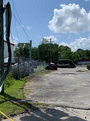
0147 PM Tstm Wnd Gst 1 W Siler 36.94N 84.06W
05/26/2024 E80 MPH Knox KY NWS Storm Survey
Trees down in multiple locations along
Industrial Blvd, just SSE of US Hwy-25 E.
0148 PM Tornado Siler 36.95N 84.05W
05/26/2024 Knox KY NWS Storm Survey
NWS Damage Survey Team concluded a tornado
touched down near the Legacy Chevrolet and
continued on towards Lynn Camp Middle/High
School. Time determined by surveillance video
and radar.
0149 PM Tstm Wnd Dmg Levi Jackson Wilderness 37.08N 84.04W
05/26/2024 Laurel KY Emergency Mngr
Large tree blown down onto trampoline and
fence enclosure near Levi Jackson Park. Time
estimated from radar.
0151 PM Tstm Wnd Gst 1 ESE London-Corbin Air 37.08N 84.07W
05/26/2024 M60 MPH Laurel KY ASOS
ASOS station KLOZ London-Corbin Apt.
0151 PM Tstm Wnd Dmg 2 ENE Sublimity City 37.11N 84.05W
05/26/2024 Laurel KY Emergency Mngr
Laurel County EM reports damage to at least
one building at Flea Land Flea Market in
London. Photos show roof missing of one
building. Radar showed possible brief
rotation.
0151 PM Tstm Wnd Dmg 2 NNW Garrich 36.96N 83.95W
05/26/2024 Knox KY NWS Storm Survey
Multiple trees were felled along Middlefork
Richland Road near US-25 just east of
Corbin. Estimated wind speeds of 70 mph.
0153 PM Lightning 1 NNW London 37.13N 84.09W
05/26/2024 Laurel KY Public
Video shows lightning striking business and
starting structure fire in London. Structure
was reported as a total loss. Time estimated
via radar.
0159 PM Tstm Wnd Dmg Fonde 36.60N 83.88W
05/26/2024 Bell KY Public
Trees uprooted and power lines down in Fonde
area. Location estimated. Report via social
media with photo. Time estimated by radar.
0200 PM Tstm Wnd Dmg 3 WNW Bronston 37.01N 84.67W
05/26/2024 Pulaski KY Trained Spotter
Multiple trees blown down including over
power lines in the vicinity of Bridge
Hollow, Slate Branch Spur and Slate Branch
roads.
0200 PM Non-Tstm Wnd Gst Yeager 36.87N 83.83W
05/26/2024 M49 MPH Knox KY Mesonet
Mesonet station BMBL Barbourville 3 E.
0200 PM Tstm Wnd Dmg 2 S Grange City 38.21N 83.66W
05/26/2024 Fleming KY 911 Call Center
Tree down in roadway. Time estimated via
radar.
0201 PM Non-Tstm Wnd Gst Somerset Pulaski County 37.05N 84.61W
05/26/2024 M59 MPH Pulaski KY Mesonet
Mesonet station SOMK2 Somerset RAWS.
0202 PM Tstm Wnd Dmg 1 NW Mariba 37.92N 83.59W
05/26/2024 Menifee KY 911 Call Center
Power lines down on unoccupied vehicle. Time
estimated by radar.
0202 PM Tstm Wnd Dmg 1 ESE Frenchburg 37.95N 83.60W
05/26/2024 Menifee KY 911 Call Center
Reports of trees and power lines down
throughout the county. Time estimated by
radar.
0205 PM Tstm Wnd Dmg Horse Creek Junction 37.14N 83.77W
05/26/2024 Clay KY 911 Call Center
Trees reported down countywide.
0206 PM Tstm Wnd Dmg Hima 37.12N 83.78W
05/26/2024 Clay KY 911 Call Center
Tree and electric lines down on house on
Lucy Lane off KY Hwy 80. House caught on
fire.
0207 PM Tstm Wnd Dmg Pineville 36.76N 83.70W
05/26/2024 Bell KY Public
Large tree snapped on Oak Drive in
Pineville. Report with photo via social
media. Time estimated via radar.
0208 PM Tstm Wnd Dmg Littleton 37.17N 83.75W
05/26/2024 Clay KY 911 Call Center
Trees down on apartment building at Beech
Creek Apartments. Building had to be
evacuated.
0208 PM Tstm Wnd Dmg 1 SE Beattyville 37.57N 83.70W
05/26/2024 Lee KY 911 Call Center
Numerous reports of trees down across roads
throughout the county. A few phone lines
also down throughout the county. Time
estimated by radar.
0208 PM Tstm Wnd Dmg 1 NNE Manchester 37.16N 83.76W
05/26/2024 Clay KY 911 Call Center
*** 1 INJ ***
Tree down on picnic shelter at Rawlings
Stintson Park. 1 person sustained non-life
threatening injury and transported by
ambulance. Time estimated via radar.
0210 PM Tstm Wnd Dmg 1 ESE Noetown 36.62N 83.74W
05/26/2024 Bell KY Public
Social media report with photo of large tree
down at East End Trailer Park near Lower
Gibson Lane in Middlesboro. Time estimated
by radar.
0211 PM Tstm Wnd Dmg Middlesboro 36.62N 83.71W
05/26/2024 Bell KY Public
Large tree down on house at Virginia Ave in
Middlesboro. Report with photo via social
media. Tine estimated by radar.
0211 PM Tstm Wnd Dmg 1 WNW Lida 37.09N 83.96W
05/26/2024 Laurel KY Trained Spotter
1 small tree and 1/2 of another tree blown
down in vicinity of Memory Lane.
0212 PM Tstm Wnd Dmg Beverly 36.93N 83.53W
05/26/2024 Bell KY Trained Spotter
Tree blown down at Cow Fork and KY-2011
intersection. Time estimated from radar.
0212 PM Tstm Wnd Dmg 1 S Beverly 36.91N 83.54W
05/26/2024 Bell KY Trained Spotter
Two trees blown down on Mud Lick Rd. Time
estimated from radar.
0213 PM Tstm Wnd Dmg 1 ESE Middlesboro 36.61N 83.71W
05/26/2024 Bell KY Public
Social media report with drone photos of
large trees down on the east side of
Middlesboro. Time estimated by radar.
0214 PM Tstm Wnd Dmg 1 SE Middlesboro 36.61N 83.71W
05/26/2024 Bell KY Law Enforcement
Many trees blown down around the city of
Middlesboro.
0214 PM Tstm Wnd Dmg 1 NNW Kettle Island 36.80N 83.61W
05/26/2024 Bell KY Public
Tree snapped at its base at a residence in
Kettle Island. Power lines appear down in
photo via social media. Time estimated by
radar.
0214 PM Tstm Wnd Dmg 1 NNE Rella 36.85N 83.63W
05/26/2024 Bell KY Public
Social media report of tree down blocking
the highway across KY 66 at MM 8.
0216 PM Tstm Wnd Dmg Calvin 36.72N 83.63W
05/26/2024 Bell KY Emergency Mngr
Tree blown down on KY-1534 about 1/4 mile
off of US-119.
0220 PM Tstm Wnd Gst 1 SW Munson 38.22N 83.48W
05/26/2024 M40 MPH Rowan KY Mesonet
Mesonet station MRHD Morehead 4 NE.
0227 PM Tstm Wnd Dmg Wrigley 38.02N 83.27W
05/26/2024 Morgan KY 911 Call Center
Trees were blown down on KY 7 near Wrigley.
The event time is radar estimated.
0229 PM Tstm Wnd Dmg Licking River 37.94N 83.29W
05/26/2024 Morgan KY 911 Call Center
A tree was blown down near 3000 Liberty
Road. The event time is radar estimated.
0231 PM Tstm Wnd Dmg Buckhorn 37.35N 83.47W
05/26/2024 Perry KY Public
Social media report of trees down in
Buckhorn. One downed tree demolished a swing
set and trampoline. Time estimated by radar.
0231 PM Tstm Wnd Dmg 1 NE Hyden 37.17N 83.36W
05/26/2024 Leslie KY Broadcast Media
Several trees and powerlines were blown down
and one fell on a mobile home severely
damaging it. The event time is estimated
from radar.
0234 PM Tstm Wnd Dmg 1 ESE Helechawa 37.76N 83.33W
05/26/2024 Morgan KY 911 Call Center
A tree was blown down on KY 191 near Adele
and Helechawa. The event time is radar
estimated.
0235 PM Tstm Wnd Gst 1 N Keith 36.87N 83.37W
05/26/2024 M48 MPH Harlan KY AWOS
AWOS station KI35 Harlan Apt.
0238 PM Tstm Wnd Dmg Redbud 36.86N 83.17W
05/26/2024 Harlan KY 911 Call Center
Trees and power lines down at residence on
James Court. Time estimated via radar.
0240 PM Tstm Wnd Dmg 2 W Hazard 37.25N 83.23W
05/26/2024 Perry KY Public
Large limbs reported down via mPING. The
event time is radar estimated.
0241 PM Tstm Wnd Dmg Hazard 37.25N 83.20W
05/26/2024 Perry KY 911 Call Center
Numerous reports of trees and power lines
down throughout the county, including within
the city limits of Hazard. Time estimated
via radar.
0242 PM Tstm Wnd Dmg 1 NW Hazard 37.27N 83.21W
05/26/2024 Perry KY 911 Call Center
Trees were reported to have been blown down.
The event time is radar estimated.
0244 PM Tstm Wnd Dmg Viper 37.18N 83.15W
05/26/2024 Perry KY 911 Call Center
Trees were reported to have been blown down.
The event time is radar estimated.
0245 PM Tstm Wnd Dmg 2 SSE Ned 37.39N 83.26W
05/26/2024 Perry KY 911 Call Center
Trees were reported to have been blown down
at the Wendell H Ford Airport. The event
time is radar estimated.
0248 PM Tstm Wnd Dmg 2 NNW Cordia 37.30N 83.12W
05/26/2024 Perry KY 911 Call Center
Trees were reported to have been blown down.
The event time is radar estimated.
0249 PM Tstm Wnd Dmg 1 ESE Williams 37.83N 83.17W
05/26/2024 Magoffin KY 911 Call Center
A tree was reported to have been blown down
at the Morgan/Magoffin County line along US
460. The event time is radar estimated.
0249 PM Tstm Wnd Dmg 1 S Gordon 36.99N 83.02W
05/26/2024 Letcher KY Law Enforcement
Report of multiple trees down on KY 160 near
Gordon not far from Kingdom Come State Park.
The event time is radar estimated.
0249 PM Tstm Wnd Dmg Avawam 37.22N 83.28W
05/26/2024 Perry KY Public
Trees reportedly blown down onto mobile
homes, power lines and roads in the Avawam
area. Time estimated from radar.
0250 PM Tstm Wnd Dmg 2 N Laura 37.75N 82.45W
05/26/2024 Martin KY 911 Call Center
Trees were reported down near 2700 Pigeon
Roost Road near Pilgrim. The event time is
radar estimated.
0250 PM Tstm Wnd Dmg Fisty 37.33N 83.10W
05/26/2024 Knott KY Dept of Highways
Trees down on KY 550 near the Perry County
line. The event time is radar estimated.
0253 PM Tstm Wnd Dmg 1 E Emmalena 37.34N 83.06W
05/26/2024 Knott KY Dept of Highways
Trees were reported down on KY 550 near
Montgomery Creek. The event time is radar
estimated.
0256 PM Tstm Wnd Gst NWS Office/Julian Carro 37.59N 83.32W
05/26/2024 M50 MPH Breathitt KY Mesonet
Mesonet station JCAK2 Jackson RAWS.
0258 PM Tstm Wnd Dmg Salyersville 37.75N 83.06W
05/26/2024 Magoffin KY 911 Call Center
A tree was blown down in the city of
Salyersville. The event time is radar
estimated.
0259 PM Tstm Wnd Dmg Cyrus 37.79N 83.05W
05/26/2024 Magoffin KY 911 Call Center
Trees were blown down along Old Lick Creek
Road. The event time is radar estimated.
0300 PM Tstm Wnd Gst 1 WNW Big Black Mountai 36.92N 82.91W
05/26/2024 M51 MPH Harlan KY Mesonet
Mesonet station BMTN Harlan 24 E.
0303 PM Tstm Wnd Dmg Whitco 37.12N 82.86W
05/26/2024 Letcher KY 911 Call Center
Numerous reports of trees and power lines
down throughout the county.
0304 PM Tstm Wnd Dmg 1 SSE Leatha 37.81N 83.01W
05/26/2024 Magoffin KY 911 Call Center
Trees were reported to have been blown down
along Mine Fork Road. The event time is
radar estimated.
0305 PM Tstm Wnd Dmg Skaggs 37.68N 83.03W
05/26/2024 Magoffin KY 911 Call Center
A tree was blown down along Route
7/Southeast Licking River Road south of
Salyersville. The event time is radar
estimated.
0305 PM Tstm Wnd Gst 1 NE Vest 37.41N 82.99W
05/26/2024 M46 MPH Knott KY Mesonet
Mesonet station VEST Hindman 5 N.
0306 PM Tstm Wnd Dmg Mousie 37.42N 82.88W
05/26/2024 Knott KY Dept of Highways
Trees were reported to have been downed on
KY 550 in the Jones Fork Community. The
event time is radar estimated.
0313 PM Tstm Wnd Dmg Bosco 37.50N 82.84W
05/26/2024 Floyd KY 911 Call Center
Trees were reported to have been blown down
in Hueysville. The event time is radar
estimated.
0317 PM Tstm Wnd Dmg 1 SSW Blue River 37.61N 82.85W
05/26/2024 Floyd KY Dept of Highways
Trees were reported down near KY 404 and KY
1210 intersection. The event time is radar
estimated.
0322 PM Tstm Wnd Dmg Virgie 37.33N 82.58W
05/26/2024 Pike KY Dept of Highways
Trees were reported to have been blown down
in Virgie. The event time is radar
estimated.
0323 PM Tstm Wnd Dmg Martin 37.57N 82.76W
05/26/2024 Floyd KY 911 Call Center
Trees were reported to have been blown down
in Martin. The event time is radar
estimated.
0326 PM Tstm Wnd Dmg 1 ENE Grethel 37.50N 82.62W
05/26/2024 Floyd KY Dept of Highways
Trees were reported to have been blown down
on KY 1426 in the Toler Creek community. The
event time is radar estimated.
0326 PM Tstm Wnd Dmg 1 N Dana 37.58N 82.70W
05/26/2024 Floyd KY Public
A tree was blown down onto KY 1426 in the
Prater Creek Community.
0327 PM Tstm Wnd Dmg 1 SW Allen 37.60N 82.74W
05/26/2024 Floyd KY 911 Call Center
Trees and utility lines were blown down on
Oklahoma Hollow near Allen. The event time
is radar estimated.
0328 PM Tstm Wnd Dmg 2 SW Shelbiana 37.40N 82.52W
05/26/2024 Pike KY Public
Multiple trees were reported to have been
blown down on Collins Street including one
onto a utility line. Trees were also down on
Collins Hwy nearby.
0328 PM Tstm Wnd Dmg 3 ESE Osborn 37.46N 82.57W
05/26/2024 Pike KY Public
Trees were down near the intersection of
Island Creek Road/KY 1426 Hoopwood Branch.
This is a public report via Social Media.
The event time is radar estimated.
0329 PM Tstm Wnd Dmg Banner 37.60N 82.70W
05/26/2024 Floyd KY 911 Call Center
Trees were reported to have been blown down.
The event time is radar estimated.
0332 PM Tstm Wnd Dmg Wells Chapel 37.83N 82.70W
05/26/2024 Johnson KY 911 Call Center
A tree was blown down near Boons Camp. The
event time is radar estimated.
0332 PM Tstm Wnd Dmg 2 NE Pikeville 37.49N 82.49W
05/26/2024 Pike KY 911 Call Center
A tree was reported to have been blown down
on Town Mountain Road on Social Media. The
event time is radar estimated.
0333 PM Tstm Wnd Dmg 1 NW Ashcamp 37.28N 82.45W
05/26/2024 Pike KY Public
Trees and powerlines down on Ashcamp
Mountain/KY 195 near Ashcamp. This is a
public report via Social Media. The event
time is radar estimated.
0333 PM Tstm Wnd Dmg Ashcamp 37.27N 82.43W
05/26/2024 Pike KY 911 Call Center
Trees were reported to have been
blown down. The event time is radar
estimated.
0334 PM Tstm Wnd Dmg 2 NW Regina 37.39N 82.44W
05/26/2024 Pike KY Public
A tree was down onto US 460/KY 80 near the
Old Millard High School. This is a public
report via Social Media. The event time is
radar estimated.
0337 PM Tstm Wnd Dmg Belcher 37.34N 82.37W
05/26/2024 Pike KY Public
A tree was down on KY 80 between Solid Waste
Department and Ferrells Creek Road. This is
a public report via Social Media. The event
time is radar estimated.
0341 PM Tstm Wnd Dmg 1 SE Stidham 37.87N 82.57W
05/26/2024 Martin KY 911 Call Center
A tree was down near 1000 Tomahawk Road
Tomahawk, KY. The event time is radar
estimated.
0350 PM Tstm Wnd Dmg 3 SSE Mcandrews 37.52N 82.25W
05/26/2024 Pike KY Public
A tree was down blocking the road in Upper
Pond Creek at Ballfork Mountain. This is a
public report via Social Media. The event
time is radar estimated.
0351 PM Tstm Wnd Dmg Warfield 37.84N 82.43W
05/26/2024 Martin KY 911 Call Center
Trees down on Beauty Road. The event time is
radar estimated.
0351 PM Tstm Wnd Dmg Belfry 37.63N 82.27W
05/26/2024 Pike KY Law Enforcement
Trees were reported to have been downed in
the Belfry area. The event time is radar
estimated.
0354 PM Tstm Wnd Dmg 2 SSE Hardy 37.59N 82.22W
05/26/2024 Pike KY Public
A tree was down on Mudlick of Hardy that
brought down powerlines. This is a public
report via Social Media. The event time is
radar estimated.
0712 PM Tstm Wnd Dmg Noetown 36.62N 83.76W
05/26/2024 Bell KY Public
2 large trees down on Stone Creek Drive.
Report via social media.
0118 AM Tstm Wnd Dmg 3 SW Zula 36.73N 85.00W
05/27/2024 Wayne KY Public
Large limbs reported to have been blown
down. Public report via mPING.
0135 AM Tstm Wnd Dmg 3 WNW Mill Springs 36.95N 84.83W
05/27/2024 Wayne KY Law Enforcement
Numerous 911 calls reporting roof collapse
at Conley Bottom Resort main pier on Lake
Cumberland with people trapped on the boats.
0143 AM Tstm Wnd Dmg Irvine 37.70N 83.97W
05/27/2024 Estill KY Public
Trees were reported to have been blown down
at 77 River Drive between Irvine and
Ravenna. The event time is radar estimated.
0155 AM Tstm Wnd Dmg 2 WSW London 37.12N 84.11W
05/27/2024 Laurel KY 911 Call Center
A large tree was blown down in front of 266
Waterworks Road. The event time is radar
estimated.
0158 AM Tstm Wnd Dmg 2 S Keavy 36.98N 84.17W
05/27/2024 Laurel KY 911 Call Center
A large tree was blown down onto Level Green
Road near Keavy. The event time is radar
estimated.
0203 AM Tstm Wnd Dmg 1 ENE London 37.13N 84.07W
05/27/2024 Laurel KY 911 Call Center
A tree fell onto a residence on Camelot
Place in the city of London. The event time
is radar estimated.
0204 AM Tstm Wnd Dmg 1 NNE High Falls 37.74N 83.58W
05/27/2024 Wolfe KY Public
A tree was reported to have been blown down
tree down near Quillen Chapel Exit 42 of the
Mountain Parkway. The event time is radar
estimated.
0217 AM Tstm Wnd Dmg 2 SE Chenowee 37.52N 83.46W
05/27/2024 Breathitt KY Public
A tree was reported to have been blown down
via Social Media. The event time is radar
estimated.
0217 AM Tstm Wnd Dmg 1 NE Cannon 36.92N 83.85W
05/27/2024 Knox KY 911 Call Center
A tree was reported to have been blown down
on KY 11 about 4 miles north of
Barbourville. The event time is radar
estimated.
0312 AM Tstm Wnd Dmg Harlan 36.84N 83.32W
05/27/2024 Harlan KY Public
Trees were reported to have been blown down
on Olive Street via Social Media. The event
time is radar estimated.
Environment
The surface analysis with radar (Figure 1) shows convection initiating over Oklahoma and Kansas during the evening of the 25th ahead of a dryline. As the storms advanced eastward, they coalesced into a mesoscale convective system (MCS) overnight before becoming a cold-pool driven quasi-linear convective system (QLCS) over the Lower Ohio Valley on the morning of the 26th. While the mesoanalysis (Figure 2) suggested relatively modest shear, building moderate instability and dry air in the mid-levels ahead of the QLCS were favorable for maintaining and even enhancing the QLCS as it progressed across eastern Kentucky during the early afternoon hours of the 26th. The surface analysis with radar (Figure 1) shows the second QLCS developing over the Missouri during the afternoon and evening hours on the 26th and then diving southeastward overnight and into the morning hours of the 27th. Instability recovery was sufficient to sustain another round of severe weather for the Lake Cumberland area during the early morning hours of the 27th. Further east, the environment remained relatively stable, causing the storms to weaken with eastward extent.
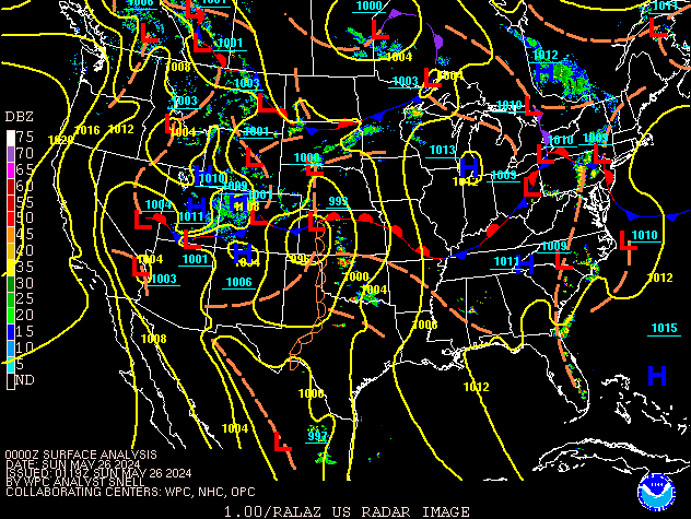 |
| Figure 1: Radar and Surface Analysis from 8 PM EDT, May 25th through 8 AM EDT May 27th, 2024 |
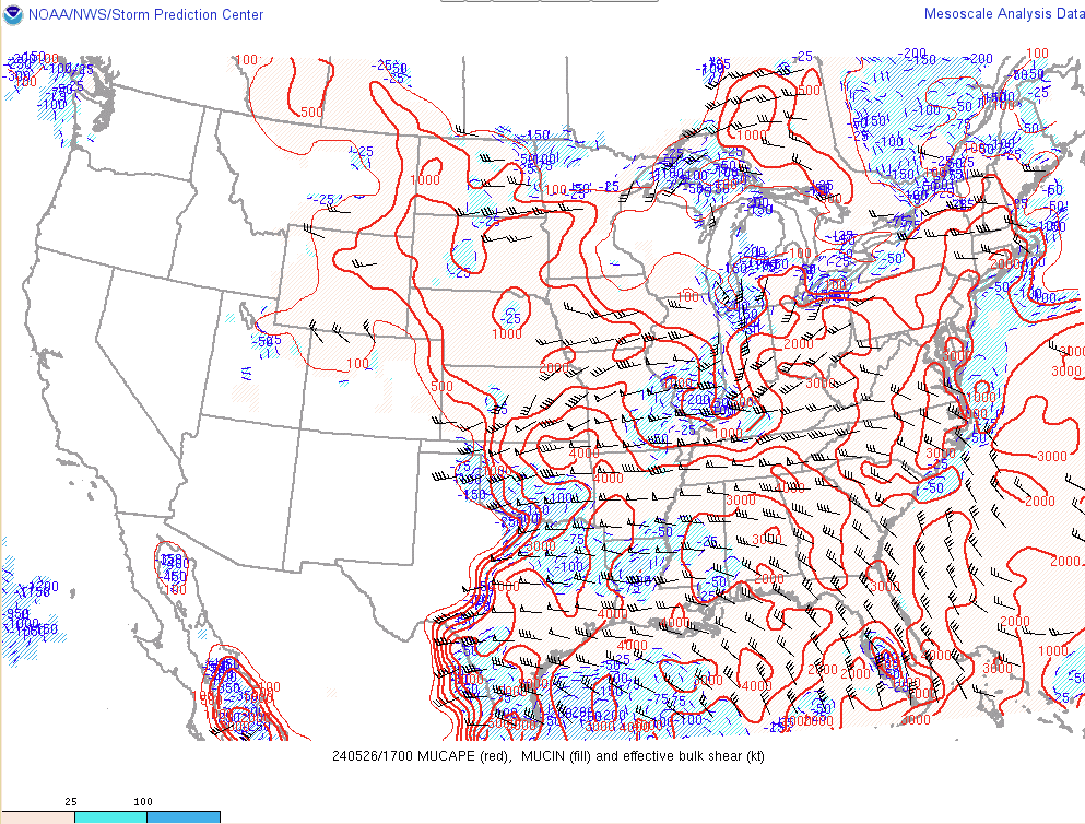 |
| Figure 2: Effective Shear (knots) and Most Unstable CAPE (Joules/kilogram) analyzed at 1 PM EDT, May 26th, 2024 |
 |
Media use of NWS Web News Stories is encouraged! Please acknowledge the NWS as the source of any news information accessed from this site. |
|