Overview
|
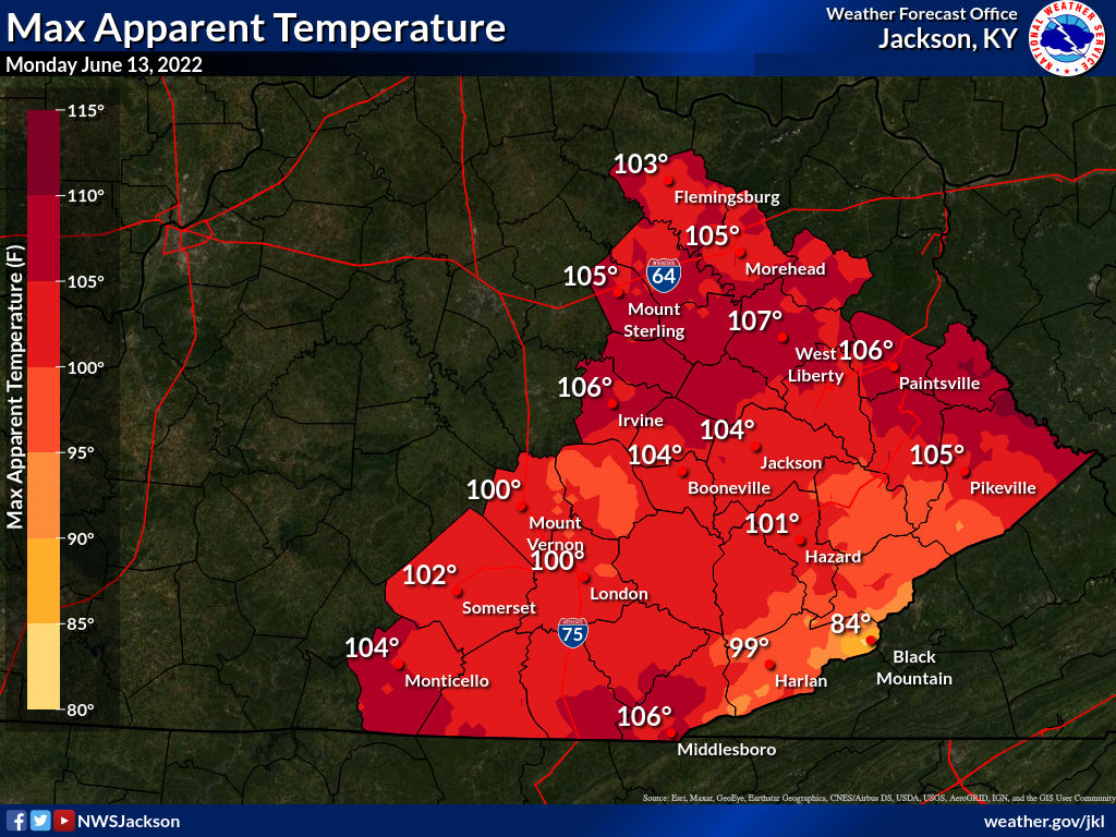
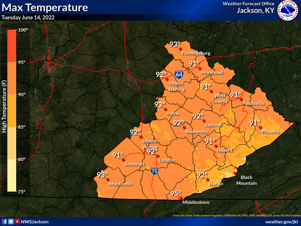
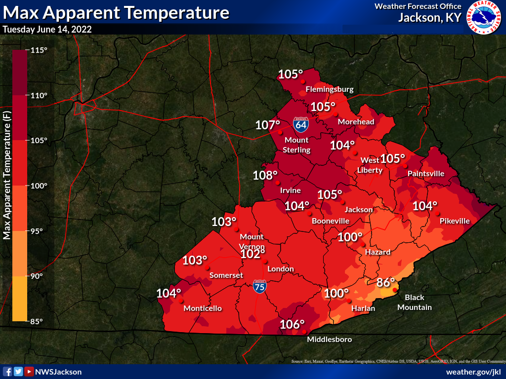
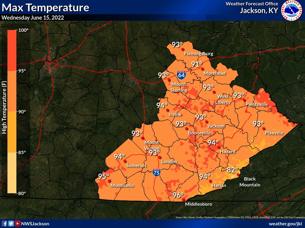
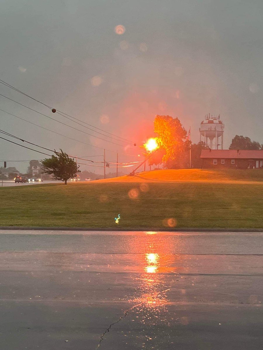
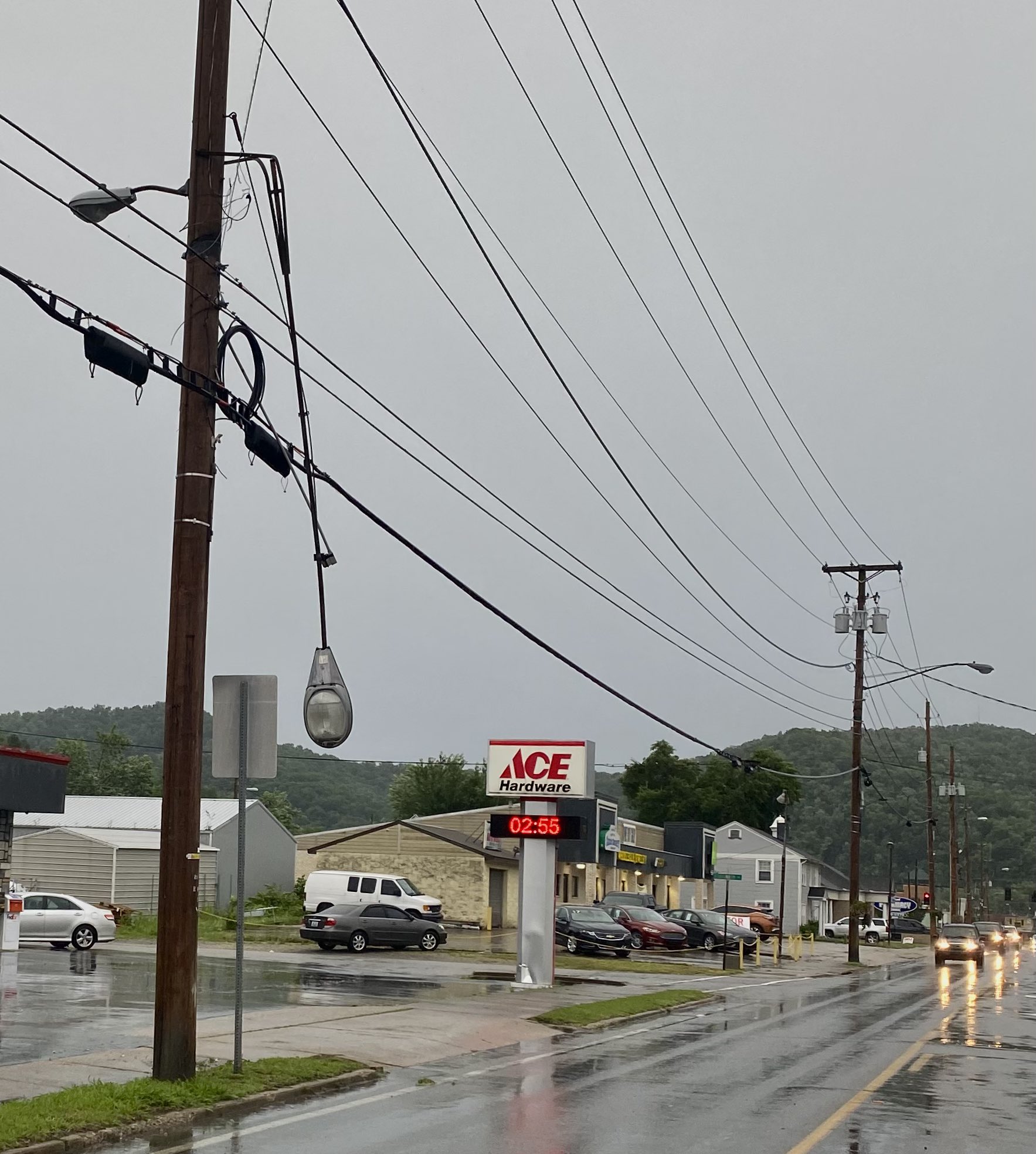
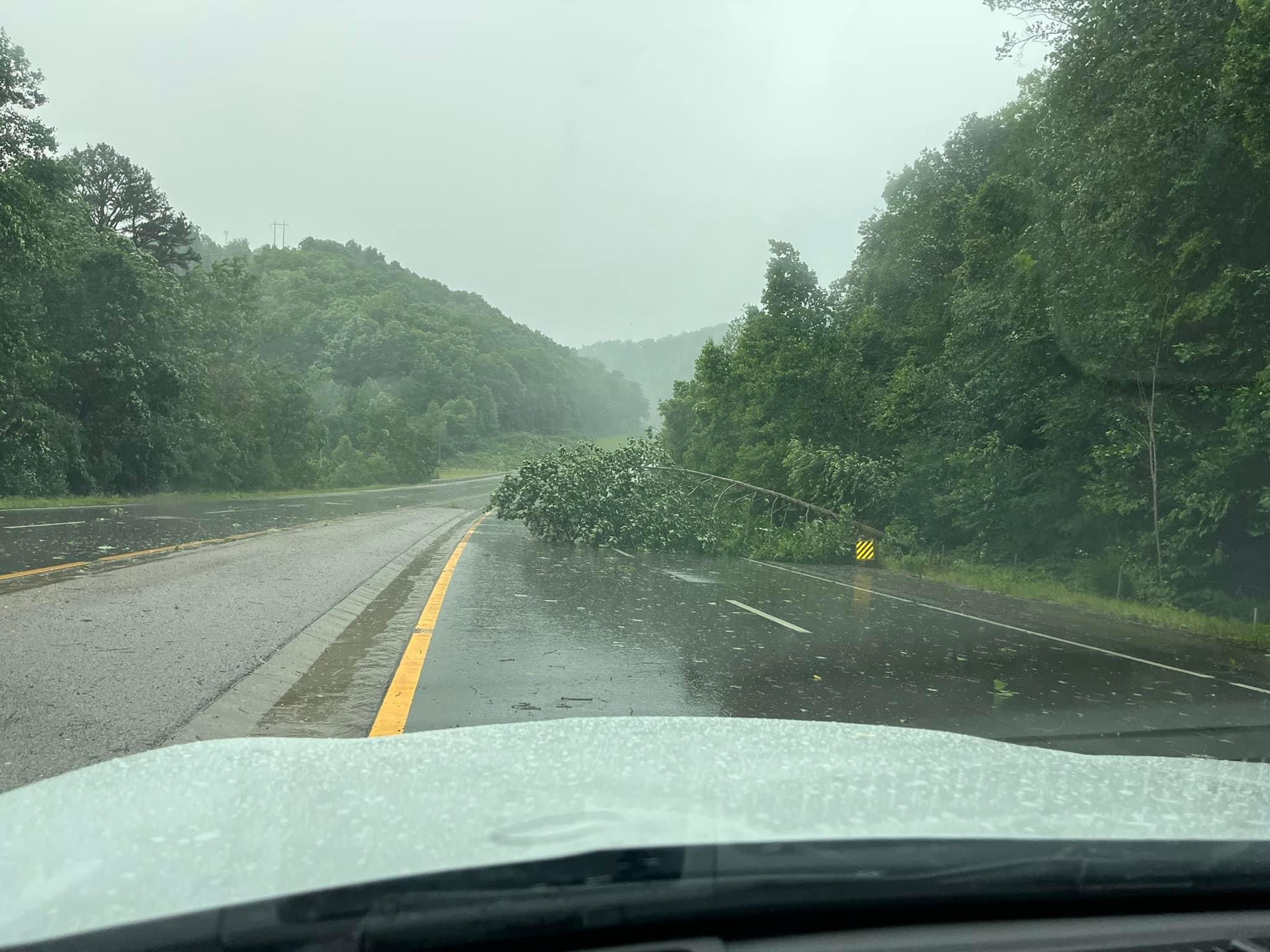
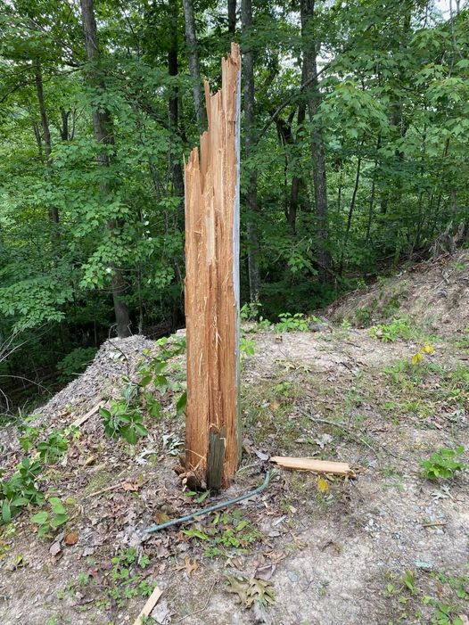
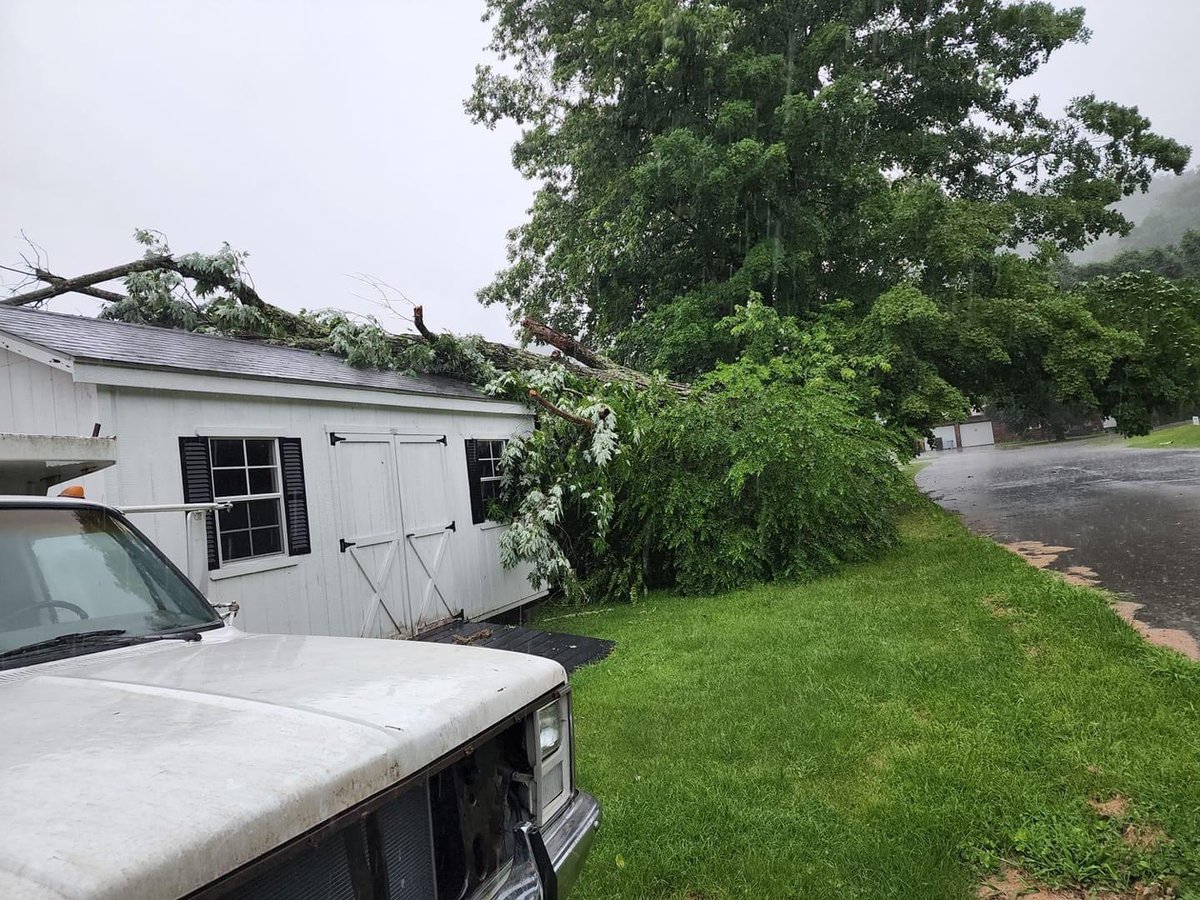
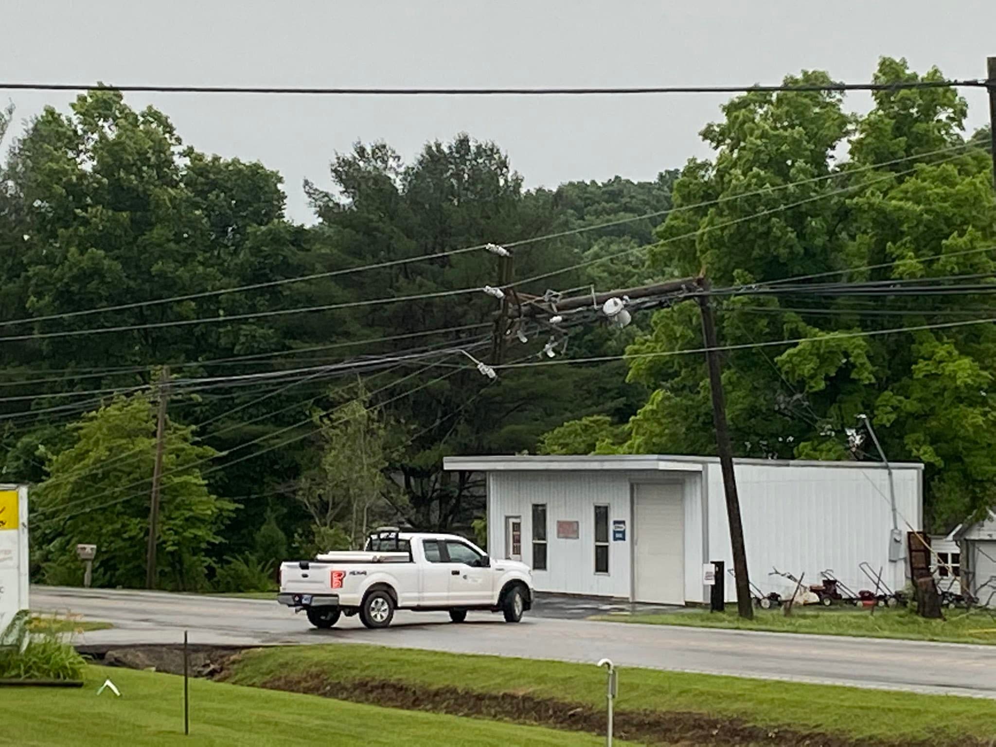
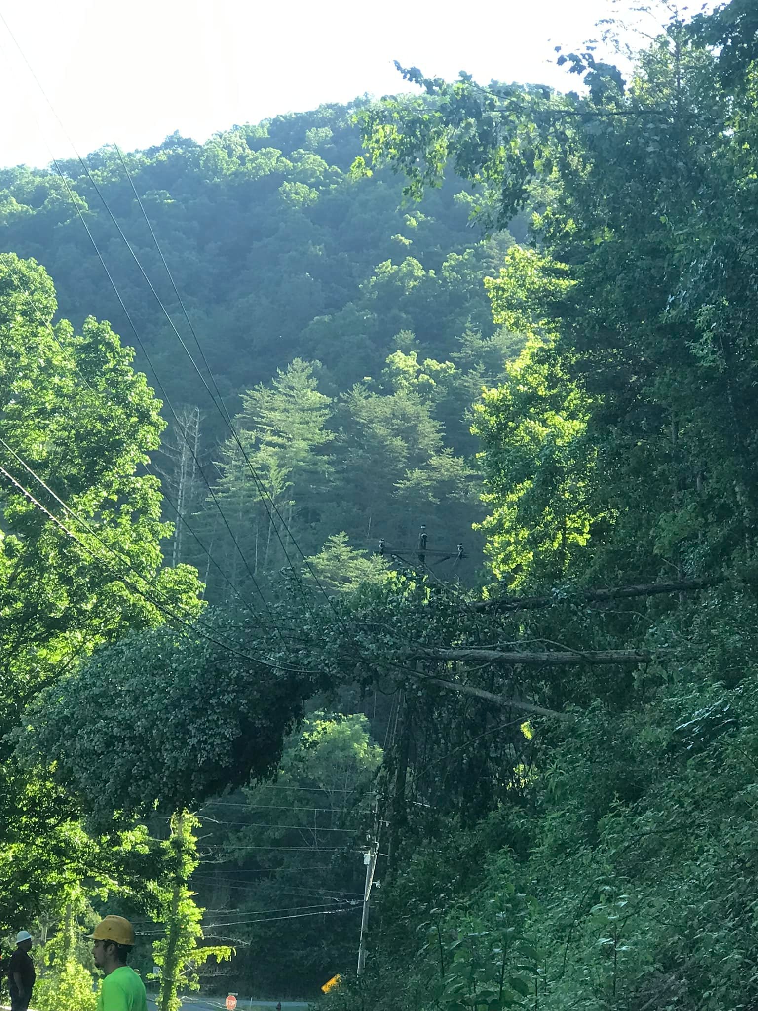
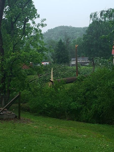
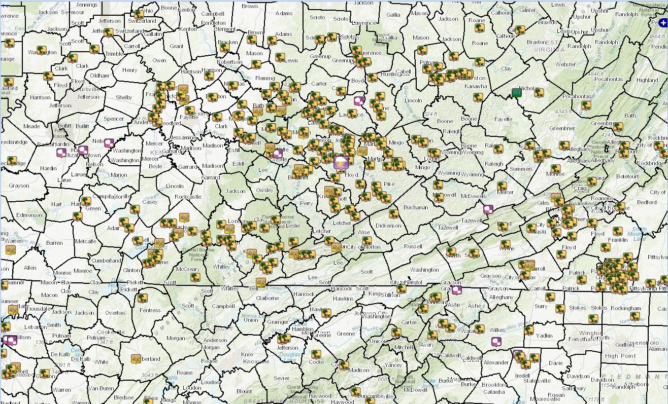
A dome of high pressure ridging resided over the region from Monday, June 13th through Thursday, June 16th, bringing with it the first heat wave of the summer. Temperatures soared well into the 90s at the lower elevations each day. Both of the eastern Kentucky climate sites, London-Corbin Airport and the Jackson Weather Office, broke their daily record highs by 1 to 3 degrees each day. Dew points in the lower to mid 70s on most days made those temperatures feel even more oppressive as heat indices soared into the 100 to 110F range each afternoon. A complex of thunderstorms developed over the Missouri Valley ahead of a cold front during the predawn hours of Friday, June 17th. This system arrived in the Ohio Valley near dawn and caused damaging winds in portions of Illinois, Indiana, and western Kentucky. The system weakened briefly during the morning, but the remnants encountered a very moist, unstable airmass leading to intensifying showers and thunderstorms over the Bluegrass Region as the system approached eastern Kentucky at midday. As the thunderstorm complex continued east of I-75, it brought powerful wind gusts which downed trees, power poles, and power lines across many counties stretching from the Bluegrass Region all the way to the Virginia and West Virginia borders. The greatest concentrations of damage were near and north of the Mountain Parkway and near the Tug Fork River from Martin County to the Belfry and South Williamson vicinity. Several counties along and south of Highway 80 and the Hal Rogers Parkway down to the Tennessee border also experienced damaging severe thunderstorm winds, with many trees and power lines blown down. The severe thunderstorms crossed the region quickly, exiting the area by around 230 PM. Widespread wind gusts in the 40 to 65 mph range occurred with several localized gusts of 65 to 80 mph likely occurring based on radar data and damage reports of leveled barns or outbuildings, loss of roofing material from structures, uprooted trees, and snapped utility poles. Based on radar velocity data, some counties may have experienced the strong to damaging winds for at least 15 to 25 minutes as the storms rolled through, which greatly contributed to the widespread damage reports received. In fact, it is likely that thousands of trees and limbs were downed, dozens of power poles were broken, and many miles of powerlines were blown down during this event. Well over 100 local storm reports were received by the National Weather Service Office at Jackson. More than 800 severe wind reports were issued for the entire event with a majority of the reports coming from Kentucky, Indiana, Tennessee, West Virginia, Virginia, and the Carolinas. Eastern Kentucky appeared to have among the greatest concentrations of damaging wind reports for that date. Immediately following the event on Friday afternoon, approximately 35,000 customers were without power in the 33 county NWS Jackson, Kentucky County Warning Area. Some of the most extensive power outages were in Elliott, Martin, Johnson, and Floyd counties. Power outages extended over 24 hours for some with about 10,000 still without power around sunset on Saturday the 18th. Crews continued to restore power to customers on Sunday the 19th and Monday the 20th, with power having been restored in most locations by sunset on the 20th. A map of the wind damage reports from eastern Kentucky and nearby areas can be found under the Storm Reports tab. A national map of severe storm reports on June 17th can be viewed here. |
 Downed Power Pole in Rowan County (Courtesy of Johnny Feltner) |
Monday, June 13th Temperatures

MONDAY HIGH TEMPERATURE REPORTS

Location                      Temp     Provider

Bath County
Owingsville 4 S               92 F     KYMN2

Bell County
Yellow Creek RAWS             94 F     RAWS
Middlesboro                   93 F     DAVIS
Middlesboro Apt               93 F     AWOS
Middlesboro                   92 F     CWOP

Breathitt County
NWS Jackson                   94 F     ASOS
Jackson 3 SE                  92 F     KYMN2
Jackson RAWS                  92 F     RAWS
Quicksand                     91 F     COOP

Clay County
Peabody RAWS                  94 F     RAWS
Manchester                    94 F     CWOP

Estill County
Irvine                        93 F     CWOP
Cressy                        91 F     COOP

Floyd County
Prestonsburg 3 WSW            93 F     COOP

Harlan County
Harlan Apt                    92 F     AWOS
Harlan 24 E                   74 F     KYMN2

Jackson County
McKee 5 S                     90 F     KYMN2

Johnson County
Paintsville 4 W               92 F     KYMN2
Paintsville 1 E               90 F     COOP

Knott County
Hindman 5 N                   91 F     KYMN2

Knox County
Barbourville 3 E              94 F     KYMN2

Laurel County
London-Corbin Apt             94 F     ASOS

Lee County
Beattyville 4N                91 F     COOP

Letcher County
Whitesburg 2 NW               91 F     KYMN2
Skyline                       91 F     COOP
Whitesburg 2 SE               86 F     COOP

Magoffin County
Salyersville                  93 F     COOP

Martin County
Big Sandy RAWS                91 F     RAWS
Big Sandy Apt                 91 F     AWOS
Inez 2 E                      84 F     COOP

McCreary County
Whitley City 3 N              92 F     KYMN2

Montgomery County
Mount Sterling                93 F     CWOP
Mount Sterling                93 F     COOP
Mount Sterling Apt            91 F     AWOS

Morgan County
West Liberty 2 SW             92 F     KYMN2
Wellington                    88 F     CWOP

Owsley County
Booneville 2 S                93 F     KYMN2

Perry County
Hazard Apt                    91 F     AWOS

Pike County
Pikeville                     92 F     DAVIS
Pike County Apt               89 F     AWOS
Pikeville 13 S                84 F     KYMN2

Powell County
Stanton 2 W                   93 F     COOP

Pulaski County
Ferguson                      95 F     AWS
Somerset RAWS                 94 F     RAWS
Eubank                        94 F     DAVIS
Burnside                      94 F     DAVIS
Somerset                      93 F     CWOP
Somerset Apt                  93 F     AWOS
Somerset 7 NNE                92 F     KYMN2
Somerset 1 SSW                92 F     AWS

Rockcastle County
Broadhead                     94 F     DAVIS

Rowan County
Morehead 4 NE                 91 F     KYMN2
Morehead Apt                  91 F     AWOS
Triangle Mtn RAWS             89 F     RAWS

Wayne County
Monticello Apt                95 F     AWOS
Monticello                    94 F     CWOP
Monticello                    94 F     DAVIS

Whitley County
Williamsburg                  93 F     CWOP
Williamsburg Apt              93 F     AWOS

Wolfe County
Koomer Ridge RAWS             93 F     RAWS
Campton                       90 F     DAVIS

Observations are collected from a variety of sources with varying
equipment and exposures. We thank all volunteer weather observers
for their dedication. Not all data listed are considered official.
These temperatures and high humidity levels resulted in heat indices (apparent temperatures) in excess of 100 degrees at many locations.
Tuesday, June 14th Temperatures
TUESDAY HIGH TEMPERATURE REPORTS

Location                      Temp     Provider

Bath County
Owingsville 4 S               93 F     KYMN2

Bell County
Middlesboro Apt               96 F     AWOS
Yellow Creek RAWS             94 F     RAWS
Middlesboro                   93 F     CWOP
Middlesboro                   92 F     DAVIS

Breathitt County
NWS Jackson                   93 F     ASOS
Jackson 3 SE                  92 F     KYMN2
Jackson RAWS                  91 F     RAWS
Quicksand                     90 F     COOP

Clay County
Peabody RAWS                  92 F     RAWS
Manchester                    91 F     CWOP

Estill County
Irvine                        94 F     CWOP
Cressy                        91 F     COOP

Floyd County
Prestonsburg 3 WSW            94 F     COOP

Harlan County
Harlan Apt                    90 F     AWOS
Harlan 24 E                   72 F     KYMN2

Jackson County
McKee 5 S                     89 F     KYMN2

Johnson County
Paintsville 4 W               93 F     KYMN2
Paintsville 1 E               91 F     HADS

Knott County
Hindman 5 N                   90 F     KYMN2

Knox County
Barbourville 3 E              93 F     KYMN2

Laurel County
London-Corbin Apt             93 F     ASOS

Lee County
Beattyville 4N                90 F     COOP

Letcher County
Whitesburg 2 NW               91 F     KYMN2
Skyline                       91 F     COOP
Whitesburg 2 SE               85 F     COOP

Magoffin County
Salyersville                  92 F     COOP

Martin County
Big Sandy RAWS                92 F     RAWS
Big Sandy Apt                 92 F     AWOS
Inez 2 E                      86 F     COOP

McCreary County
Whitley City 3 N              90 F     KYMN2

Montgomery County
Mount Sterling                94 F     CWOP
Mount Sterling                94 F     COOP
Mount Sterling Apt            91 F     AWOS

Morgan County
West Liberty 2 SW             91 F     KYMN2
Wellington                    89 F     CWOP

Owsley County
Booneville 2 S                92 F     KYMN2

Perry County
Hazard Apt                    91 F     AWOS

Pike County
Pikeville                     92 F     DAVIS
Pike County Apt               90 F     AWOS
Pikeville 13 S                83 F     KYMN2

Powell County
Stanton 2 W                   92 F     COOP

Pulaski County
Ferguson                      95 F     AWS
Eubank                        94 F     DAVIS
Somerset RAWS                 93 F     RAWS
Burnside                      93 F     DAVIS
Somerset 7 NNE                92 F     KYMN2
Somerset                      92 F     CWOP
Somerset 1 SSW                91 F     AWS
Somerset Apt                  91 F     AWOS

Rockcastle County
Broadhead                     95 F     DAVIS

Rowan County
Morehead Apt                  91 F     AWOS
Morehead 4 NE                 91 F     KYMN2
Triangle Mtn RAWS             90 F     RAWS

Wayne County
Monticello Apt                94 F     AWOS
Monticello                    93 F     CWOP
Monticello                    92 F     DAVIS

Whitley County
Williamsburg Apt              93 F     AWOS
Williamsburg                  91 F     CWOP

Wolfe County
Koomer Ridge RAWS             93 F     RAWS
Campton                       90 F     DAVIS

Observations are collected from a variety of sources with varying
equipment and exposures. We thank all volunteer weather observers
for their dedication. Not all data listed are considered official.
These temperatures and high humidity levels resulted in heat indices (apparent temperatures) in excess of 100 degrees at many locations.
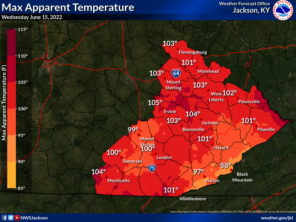
Wednesday, June 15th Temperatures
WEDNESDAY HIGH TEMPERATURE REPORTS

Location                      Temp     Provider

Bath County
Owingsville 4 S               94 F     KYMN2

Bell County
Yellow Creek RAWS             97 F     RAWS
Middlesboro Apt               96 F     AWOS

Breathitt County
Jackson RAWS                  96 F     RAWS
Jackson 3 SE                  94 F     KYMN2
NWS Jackson                   94 F     ASOS
Quicksand                     92 F     COOP

Clay County
Peabody RAWS                  97 F     RAWS

Estill County
Cressy                        92 F     COOP

Floyd County
Prestonsburg 3 WSW            95 F     COOP

Harlan County
Harlan Apt                    92 F     AWOS
Harlan 24 E                   81 F     KYMN2

Jackson County
McKee 5 S                     90 F     KYMN2

Johnson County
Paintsville 4 W               94 F     KYMN2
Paintsville 1 E               92 F     COOP

Knott County
Hindman 5 N                   92 F     KYMN2

Knox County
Barbourville 3 E              94 F     KYMN2

Laurel County
London-Corbin Apt             95 F     ASOS

Lee County
Beattyville 4N                93 F     COOP

Letcher County
Skyline                       93 F     COOP
Whitesburg 2 NW               93 F     KYMN2
Whitesburg 2 SE               86 F     COOP

Magoffin County
Salyersville                  94 F     COOP

Martin County
Big Sandy RAWS                95 F     RAWS
Big Sandy Apt                 93 F     AWOS
Inez 2 E                      90 F     COOP

McCreary County
Whitley City 3 N              91 F     KYMN2

Montgomery County
Mount Sterling                95 F     COOP
Mount Sterling Apt            91 F     AWOS

Morgan County
West Liberty 2 SW             94 F     KYMN2

Owsley County
Booneville 2 S                94 F     KYMN2

Perry County
Hazard Apt                    93 F     AWOS

Pike County
Pike County Apt               90 F     AWOS
Pikeville 13 S                84 F     KYMN2

Powell County
Stanton 2 W                   93 F     COOP

Pulaski County
Somerset RAWS                 95 F     RAWS
Somerset Apt                  93 F     AWOS
Somerset 7 NNE                92 F     KYMN2

Rowan County
Triangle Mtn RAWS             93 F     RAWS
Morehead 4 NE                 92 F     KYMN2
Morehead Apt                  91 F     AWOS

Wayne County
Monticello Apt                95 F     AWOS

Whitley County
Williamsburg Apt              93 F     AWOS

Wolfe County
Koomer Ridge RAWS             97 F     RAWS

Observations are collected from a variety of sources with varying
equipment and exposures. We thank all volunteer weather observers
for their dedication. Not all data listed are considered official.
These temperatures and high humidity levels resulted in heat indices (apparent temperatures) in excess of 100 degrees at many locations.
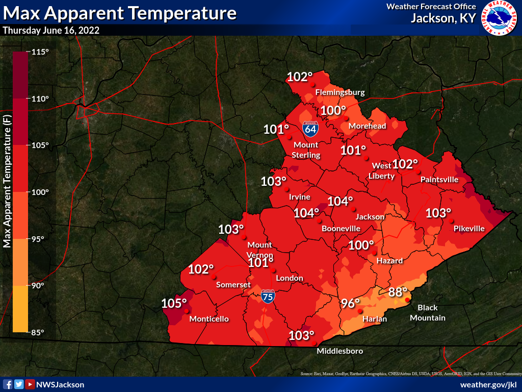
Thursday, June 16th Temperatures

THURSDAY HIGH TEMPERATURE REPORTS

Location                     Temp      Provider

Bath County
Owingsville 4 S               93 F     KYMN2

Bell County
Yellow Creek RAWS             97 F     RAWS
Middlesboro Apt               95 F     AWOS

Breathitt County
NWS Jackson                   95 F     ASOS
Jackson 3 SE                  94 F     KYMN2
Jackson RAWS                  93 F     RAWS
Quicksand                     93 F     COOP

Clay County
Peabody RAWS                  96 F     RAWS

Estill County
Cressy                        92 F     COOP

Floyd County
Prestonsburg 3 WSW            96 F     COOP

Harlan County
Harlan Apt                    93 F     AWOS
Harlan 24 E                   81 F     KYMN2

Jackson County
McKee 5 S                     90 F     KYMN2

Johnson County
Paintsville 4 W               95 F     KYMN2
Paintsville 1 E               93 F     COOP

Knott County
Hindman 5 N                   93 F     KYMN2

Knox County
Barbourville 3 E              95 F     KYMN2

Laurel County
London-Corbin Apt             95 F     ASOS

Lee County
Beattyville 4N                92 F     COOP

Letcher County
Skyline                       94 F     COOP
Whitesburg 2 NW               94 F     KYMN2
Whitesburg 2 SE               89 F     COOP

Magoffin County
Salyersville                  95 F     COOP

Martin County
Big Sandy Apt                 94 F     AWOS
Big Sandy RAWS                94 F     RAWS
Inez 2 E                      93 F     COOP

McCreary County
Whitley City 3 N              92 F     KYMN2

Montgomery County
Mount Sterling Apt            91 F     AWOS

Morgan County
West Liberty 2 SW             94 F     KYMN2

Owsley County
Booneville 2 S                94 F     KYMN2

Perry County
Hazard Apt                    95 F     AWOS

Pike County
Pike County Apt               91 F     AWOS
Pikeville 13 S                85 F     KYMN2

Powell County
Stanton 2 W                   94 F     COOP

Pulaski County
Somerset RAWS                 94 F     RAWS
Somerset Apt                  93 F     AWOS
Somerset 7 NNE                92 F     KYMN2

Rowan County
Morehead 4 NE                 91 F     KYMN2
Morehead Apt                  91 F     AWOS
Triangle Mtn RAWS             90 F     RAWS

Wayne County
Monticello Apt                95 F     AWOS

Whitley County
Williamsburg Apt              93 F     AWOS

Wolfe County
Koomer Ridge RAWS             95 F     RAWS

Observations are collected from a variety of sources with varying
equipment and exposures. We thank all volunteer weather observers
for their dedication. Not all data listed are considered official.
These temperatures and high humidity levels resulted in heat indices (apparent temperatures) in excess of 100 degrees at many locations.
Photos
 |
 |
 |
 |
| Tree Down in Front of a Prestonsburg Home (Courtesy of Allen Bowling) |
Tree Down on Power Pole in Mount Sterling (Courtesy of Johnny Feltner) |
Tree Debris on Road in Hatfield (Courtesy of Mary Runyon) |
Tree on Power Line in Elna (Courtesy of Big Sandy RECC) |
 |
 |
 |
 |
| Bent Street Lamp in Prestonsburg (Courtesy of Allen Bowling) |
Tree Down on Highway 80 in Knott County (Courtesy of Chris Hall) |
Snapped Power Pole in Martin County (Courtesy of Big Sandy RECC) |
Tree on Mobile Home in Prestonsburg Area (Courtesy of Johnny Feltner) |
 |
 |
 |
 |
| Damaged Hardee's Sign in Prestonsburg (Courtesy of Allen Bowling) |
Tree on Road in Rowan County (Courtesy of Joe Clark) |
Snapped Power Pole in Rowan County (Courtesy of Johnny Feltner) |
Downed Tree Along Spurlock Creek, Floyd County (Courtesy of Big Sandy RECC) |
 |
 |
 |
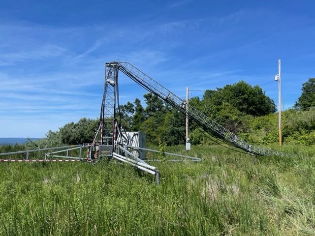 |
| Trees Blown over in Thelma (Courtesy of Big Sandy RECC) |
Destroyed Building in South Williamson Courtesy of Nee Jackson |
Uprooted and Snapped Threes in Thelma (Courtesy of Big Sandy RECC) |
Downed Tower near Elkhorn City Courtesy of Nee Jackson |
Video footage of the storm passing over Cave Run Marina can be viewed here and here.
Radar
 |
| Radar Loop from 1000 AM to 230 PM on June 17th |
Storm Reports
..TIME... ...EVENT... ...CITY LOCATION... ...LAT.LON...
..DATE... ....MAG.... ..COUNTY LOCATION..ST.. ...SOURCE....
..REMARKS..
1215 PM Tstm Wnd Gst 2 N Prewitt 38.05N 83.98W
06/17/2022 M43 MPH Montgomery KY AWOS
AWOS station KIOB Mount Sterling Apt.
1220 PM Tstm Wnd Gst 3 E Parnell 36.87N 84.90W
06/17/2022 M45 MPH Wayne KY Mesonet
Measured at the KY Mesonet station MONT.
1221 PM Tstm Wnd Gst 1 NNW Monticello 36.85N 84.85W
06/17/2022 M53 MPH Wayne KY AWOS
AWOS station KEKQ Monticello Apt.
1223 PM Tstm Wnd Dmg Susie 36.78N 84.96W
06/17/2022 Wayne KY 911 Call Center
Wayne County dispatch reported a large tree
blown down onto utility lines along Old
Susie Rd.
1224 PM Tstm Wnd Dmg 1 WSW Somerset Pulaski 37.04N 84.64W
06/17/2022 Pulaski KY 911 Call Center
Pulaski County dispatch reported trees blown
down along Bourbon Rd.
1225 PM Tstm Wnd Dmg 2 ENE Susie 36.79N 84.92W
06/17/2022 Wayne KY 911 Call Center
Wayne County 911 call center reported large
tree blown down onto KY-858 in the 1000
block.
1226 PM Tstm Wnd Dmg 1 SW Plummers Landing 38.30N 83.58W
06/17/2022 Fleming KY 911 Call Center
Corrects previous tstm wnd dmg report from 1
SW Plummers Landing. Dispatch reported a
tree down on Watson Rd. near Plummers
Landing, Kentucky. Time established from
dispatch call.
1226 PM Tstm Wnd Dmg 1 SW Grange City 38.24N 83.67W
06/17/2022 Fleming KY 911 Call Center
Corrects previous tstm wnd dmg report from 1
SW Grange City. Dispatch reported a tree
down on McRoberts Rd. near Grange City,
Kentucky. Time established from dispatch
call.
1230 PM Tstm Wnd Dmg 1 SE Rogers 37.73N 83.62W
06/17/2022 Wolfe KY 911 Call Center
Dispatch reported a tree down on Tar Ridge
Rd. near Rogers, Kentucky. Time established
from radar.
1230 PM Tstm Wnd Gst 1 SW Dabney 37.18N 84.56W
06/17/2022 M40 MPH Pulaski KY Mesonet
KY Mesonet station DABN Somerset 7 NNE.
1230 PM Tstm Wnd Dmg 1 W Mount Sterling 38.06N 83.96W
06/17/2022 Montgomery KY Emergency Mngr
Tree down across the Kroger bypass.
1230 PM Tstm Wnd Dmg 1 SSE Oggs Station 38.01N 83.82W
06/17/2022 Montgomery KY NWS Employee
Large tree limbs down at Spring Meadows
Drive and Town Branch Road.
1231 PM Tstm Wnd Dmg 2 N Monticello 36.87N 84.84W
06/17/2022 Wayne KY 911 Call Center
Wayne County 911 reported 2 large trees
blown down on KY-1275 N in the 600 block.
Time estimated from radar.
1231 PM Tstm Wnd Dmg 2 SSW Monticello 36.82N 84.86W
06/17/2022 Wayne KY 911 Call Center
Wayne County 911 call center reported a
large tree blown down across KY-167 in the
700 block.
1231 PM Tstm Wnd Dmg 1 E Clay City 37.86N 83.91W
06/17/2022 Powell KY 911 Call Center
Tree reported down on Beech Fork Road near
Clay City, KY. Time estimated from radar.
1233 PM Tstm Wnd Dmg Pointer 37.13N 84.77W
06/17/2022 Pulaski KY 911 Call Center
Pulaski County dispatch reported trees blown
down along Hickory Nut Rd.
1235 PM Tstm Wnd Gst Somerset Pulaski County 37.05N 84.62W
06/17/2022 M49 MPH Pulaski KY AWOS
AWOS station KSME Somerset Apt.
1235 PM Tstm Wnd Dmg 2 SSE Hogue 37.13N 84.69W
06/17/2022 Pulaski KY 911 Call Center
Pulaski County 911 reported trees blown down
along Hall Ridge Rd.
1235 PM Tstm Wnd Dmg 3 WNW Bronston 37.01N 84.67W
06/17/2022 Pulaski KY 911 Call Center
Pulaski County dispatch reported trees blown
down along Slate Branch Road.
1235 PM Tstm Wnd Gst 1 WNW Preston 38.09N 83.76W
06/17/2022 M55 MPH Bath KY Mesonet
KY Mesonet station PRST Owingsville 4 S.
1235 PM Tstm Wnd Dmg 2 NNW Stoops 38.15N 83.93W
06/17/2022 Bath KY Emergency Mngr
Hay barn blown over, no injuries.
1238 PM Tstm Wnd Dmg 1 SW Grade 37.06N 84.47W
06/17/2022 Pulaski KY 911 Call Center
1238 PM Tstm Wnd Dmg Salt Lick 38.12N 83.62W
06/17/2022 Bath KY Emergency Mngr
A tree was blown down onto a vehicle at the
Dollar General Store in Salt Lick.
1240 PM Tstm Wnd Gst 1 SW Munson 38.22N 83.48W
06/17/2022 M49 MPH Rowan KY Mesonet
KY Mesonet station MRHD Morehead 4 NE.
1241 PM Tstm Wnd Dmg Campton 37.73N 83.55W
06/17/2022 Wolfe KY Public
A tree was reported to have blown down on a
garage. The event time is radar estimated.
1241 PM Tstm Wnd Dmg Westbend 37.91N 83.97W
06/17/2022 Powell KY 911 Call Center
A tree reported down near 9000 Winchester
Rd. in Clay City, Kentucky. Time estimated
from radar.
1241 PM Tstm Wnd Dmg 2 NE Stanton 37.87N 83.84W
06/17/2022 Powell KY 911 Call Center
Tree reported down near 500 Hatchers Creek
Rd in Stanton, KY. Time estimated by radar.
1241 PM Tstm Wnd Dmg Stanton 37.85N 83.86W
06/17/2022 Powell KY 911 Call Center
Powell County 911 Call Center reported a
roof was blown off of an apartment complex
in Stanton, Kentucky. Time from when call
came into dispatch.
1242 PM Tstm Wnd Dmg 2 WNW Rockcastle Spring 37.03N 84.33W
06/17/2022 Pulaski KY 911 Call Center
Pulaski County dispatch reported trees blown
down onto the KY-192 approximately 18 miles
east of Somerset.
1244 PM Tstm Wnd Dmg Campton 37.74N 83.55W
06/17/2022 Wolfe KY 911 Call Center
Numerous trees reported down by dispatch
near and around Campton. Time estimated by
radar.
1244 PM Tstm Wnd Dmg Frenchburg 37.95N 83.62W
06/17/2022 Menifee KY 911 Call Center
Corrects time from previous tstm wnd dmg
report from Frenchburg. Numerous trees were
blown down in and around Frenchburg and
through out the county. A few power outages
were ongoing at 830 pm EDT.
1244 PM Tstm Wnd Dmg Salt Lick 38.12N 83.62W
06/17/2022 Bath KY Broadcast Media
A tree was blown down onto a mobile home.
The event time is radar estimated.
1245 PM Hail Campton 37.73N 83.55W
06/17/2022 E0.88 inch Wolfe KY Public
1245 PM Tstm Wnd Gst 1 WNW Cogswell 38.10N 83.51W
06/17/2022 M72 MPH Rowan KY Public
Measured at a weather station located at the
Cave Run Marinas.
1246 PM Tstm Wnd Gst 3 WNW Mill Springs 36.96N 84.83W
06/17/2022 M40 MPH Wayne KY Mesonet
FW1232 Monticello.
1246 PM Tstm Wnd Dmg 3 SE Bernstadt 37.12N 84.16W
06/17/2022 Laurel KY 911 Call Center
A tree was reported to have been blown down
onto Adams Road. The event time is radar
estimated.
1247 PM Tstm Wnd Dmg 1 SW Morehead 38.18N 83.45W
06/17/2022 Rowan KY Trained Spotter
A tree was blown down onto Old Flemingsburg
Road. The event time is radar estimated.
1248 PM Tstm Wnd Dmg 2 E Triplett 38.29N 83.37W
06/17/2022 Rowan KY Trained Spotter
A tree was blown down onto Holly Fork Road
in Rowan County. This report is via social
media with a picture.
1248 PM Tstm Wnd Dmg 1 SE Hilda 38.23N 83.50W
06/17/2022 Rowan KY Public
Powerlines were downed due to a snapped
powerpole. This report was via social media
with a picture.
1249 PM Tstm Wnd Dmg 2 SW Baldrock 36.97N 84.31W
06/17/2022 Laurel KY Public
A tree was reported to have been blown down
onto London Dock Road. The event time is
radar estimated.
1251 PM Tstm Wnd Dmg 3 E Triplett 38.30N 83.35W
06/17/2022 Rowan KY Trained Spotter
A large tree limb was down on a residence.
1254 PM Tstm Wnd Dmg 2 SSW Lytten 38.07N 83.24W
06/17/2022 Elliott KY 911 Call Center
Elliott County dispatch reported trees blown
down along Devils Fork Rd.
1256 PM Tstm Wnd Dmg Ezel 37.89N 83.45W
06/17/2022 Morgan KY Public
Trees were blown down in Ezel including onto
2 mobile homes.
1257 PM Tstm Wnd Dmg Wellington 37.92N 83.50W
06/17/2022 Menifee KY 911 Call Center
Corrects time of previous tstm wnd dmg
report from Wellington. Numerous trees were
blown down in and around Wellington and
throughout the county. A few power outages
were ongoing at 830 pm EDT.
1257 PM Tstm Wnd Gst 1 ESE London-Corbin Air 37.08N 84.07W
06/17/2022 M45 MPH Laurel KY ASOS
ASOS station KLOZ London-Corbin Apt.
1257 PM Tstm Wnd Dmg 2 SSE Lytten 38.08N 83.21W
06/17/2022 Elliott KY 911 Call Center
Elliott County dispatch reported trees blown
down onto power lines along KY-173 leading
to a temporary road closure.
1258 PM Tstm Wnd Dmg Pine Knot 36.66N 84.44W
06/17/2022 McCreary KY 911 Call Center
McCreary County 911 reported many trees down
county wide including the community of Pine
Knot.
0100 PM Tstm Wnd Dmg 1 SSE Keavy 36.99N 84.16W
06/17/2022 Laurel KY 911 Call Center
A tree was reported blown down onto KY 312
in southern Laurel County. The event time is
radar estimated.
0101 PM Tstm Wnd Dmg 3 SW Stark 38.15N 83.17W
06/17/2022 Elliott KY Public
Elliott County dispatch reported trees blown
down along KY-32 N.
0104 PM Tstm Wnd Dmg 1 WNW Lake 37.09N 83.89W
06/17/2022 Laurel KY 911 Call Center
A tree was reported to have been blown down
onto Curry Road.
0104 PM Tstm Wnd Dmg 3 N Stark 38.22N 83.14W
06/17/2022 Elliott KY 911 Call Center
Elliott County dispatch reported trees blown
down along KY-504.
0104 PM Tstm Wnd Dmg 3 WSW Bruin 38.18N 83.07W
06/17/2022 Elliott KY 911 Call Center
Elliott County dispatch reported trees blown
down along KY-649.
0104 PM Tstm Wnd Dmg 2 W Isonville 38.07N 83.09W
06/17/2022 Elliott KY 911 Call Center
Elliott County dispatch reported trees blown
down along KY-32 S.
0104 PM Tstm Wnd Dmg 3 ESE Little Sandy 38.04N 83.13W
06/17/2022 Elliott KY 911 Call Center
Elliott County dispatch reported trees blown
down along KY-719.
0105 PM Tstm Wnd Gst 1 WNW Index 37.90N 83.27W
06/17/2022 M57 MPH Morgan KY Mesonet
KY Mesonet station WLBT West Liberty 2 SW.
0105 PM Tstm Wnd Dmg 1 NNW North Corbin 36.98N 84.10W
06/17/2022 Laurel KY 911 Call Center
A tree was reported to have been blown down
onto North Stewart Road. The event time is
radar estimated.
0106 PM Tstm Wnd Dmg 2 E Dorthae 36.99N 84.06W
06/17/2022 Laurel KY 911 Call Center
A tree was reported to have been blown down
on Horse Creek Road in southern Laurel
County. The event time is radar estimated.
0107 PM Tstm Wnd Dmg 1 ESE Helechawa 37.76N 83.33W
06/17/2022 Morgan KY Trained Spotter
A tree was down on the Mountain Parkway near
Adele. The event time is radar estimated.
0108 PM Tstm Wnd Dmg 2 NE Culver 38.10N 82.97W
06/17/2022 Elliott KY 911 Call Center
Elliott County dispatch reported trees blown
down along KY-486.
0109 PM Tstm Wnd Gst Koomer Ridge Camping Gr 37.78N 83.63W
06/17/2022 M41 MPH Wolfe KY Other Federal
USFS KOMK2 Koomer Ridge RAWS.
0109 PM Tstm Wnd Dmg 1 WSW Pigeonroost 37.11N 83.83W
06/17/2022 Clay KY 911 Call Center
Trees were blown down in the Horse Creek
community. The event time is radar
estimated.
0111 PM Tstm Wnd Dmg 1 WNW Patton 37.79N 83.17W
06/17/2022 Magoffin KY 911 Call Center
Trees were reported down in the Grape Creek
area of Magoffin County. The event time is
radar estimated.
0112 PM Tstm Wnd Dmg 1 NNE West Liberty 37.92N 83.26W
06/17/2022 Morgan KY Law Enforcement
Trees were reported down in and in the
vicinity of West Liberty and elsewhere
throughout Morgan County.
0112 PM Tstm Wnd Dmg 1 WSW Foraker 37.66N 83.15W
06/17/2022 Magoffin KY NWS Employee
Tree down on Highway 30 near the Magoffin
and Breathitt County line. Time estimated
from radar.
0113 PM Tstm Wnd Dmg Bloomington 37.81N 83.15W
06/17/2022 Magoffin KY Public
Trees were reported to have been blown down.
The event time is radar estimated.
0114 PM Tstm Wnd Dmg Moon 37.98N 83.05W
06/17/2022 Morgan KY Trained Spotter
Large limbs were blown down along KY 172 in
eastern Morgan County.
0114 PM Tstm Wnd Dmg 1 SW Siler 36.93N 84.05W
06/17/2022 Knox KY 911 Call Center
Knox County dispatch reported trees blown
down onto power lines along Siler Hill Rd.
0116 PM Tstm Wnd Dmg Salyersville 37.75N 83.07W
06/17/2022 Magoffin KY 911 Call Center
Trees were reported to have been blown down
in Salyersville. The event time is radar
estimated.
0116 PM Tstm Wnd Dmg 1 SE Rousseau 37.59N 83.22W
06/17/2022 Breathitt KY NWS Employee
Large limb down on Highway 30 near Rousseau.
0118 PM Tstm Wnd Dmg 1 SW Stevenson 37.57N 83.27W
06/17/2022 Breathitt KY NWS Employee
Tree down on Highway 30 west of Rousseau.
Time estimated from radar.
0118 PM Tstm Wnd Dmg 1 SSW Noctor 37.55N 83.34W
06/17/2022 Breathitt KY NWS Employee
Tree down across Highway 30 east of Jackson.
Time estimated from radar.
0120 PM Tstm Wnd Dmg Goose Rock 37.09N 83.69W
06/17/2022 Clay KY 911 Call Center
Trees and limbs were blown down. The event
time is radar estimated.
0121 PM Tstm Wnd Dmg Falcon 37.79N 83.00W
06/17/2022 Magoffin KY 911 Call Center
Trees were reported to have been blown down
in the Falcon community.
0121 PM Tstm Wnd Dmg Royalton 37.68N 83.02W
06/17/2022 Magoffin KY 911 Call Center
Trees were reported to have been blown down
near KY 7. The event time is radar
estimated.
0122 PM Tstm Wnd Dmg Redbush 37.94N 82.95W
06/17/2022 Johnson KY Trained Spotter
A tree was down on powerlines and caught on
fire in the Redbush and Elna vicinity. The
local VFD responded. The event time is
estimated from radar.
0124 PM Tstm Wnd Dmg Flatgap 37.93N 82.89W
06/17/2022 Johnson KY 911 Call Center
Trees and limbs were reported to have been
blown down. The event time is radar
estimated.
0125 PM Tstm Wnd Dmg 2 ESE Ivyton 37.70N 82.95W
06/17/2022 Magoffin KY Public
Large tree limbs were blown down along KY
114.
0125 PM Tstm Wnd Gst Yeager 36.87N 83.83W
06/17/2022 M40 MPH Knox KY Mesonet
KY Mesonet station BMBL Barbourville 3 E.
0127 PM Tstm Wnd Gst 1 N NWS Office/Julian C 37.60N 83.32W
06/17/2022 M40 MPH Breathitt KY ASOS
ASOS station KJKL NWS Jackson.
0128 PM Tstm Wnd Dmg 2 NNW Brainard 37.69N 82.92W
06/17/2022 Floyd KY Fire Dept/Rescue
Powerlines were blown down.
0129 PM Tstm Wnd Dmg Brainard 37.66N 82.89W
06/17/2022 Floyd KY Public
Utility poles snapped with trees and large
limbs down in addition to downed powerlines
on Adams Cemetery Road and along KY 114.
0130 PM Tstm Wnd Dmg Nippa 37.86N 82.79W
06/17/2022 Johnson KY 911 Call Center
Trees were reported down in the Wittensville
and Nippa communities. The event time is
radar estimated.
0130 PM Tstm Wnd Dmg Paintsville 37.82N 82.81W
06/17/2022 Johnson KY Public
Corrects previous tstm wnd dmg report from
Paintsville. Several trees were reported to
have been blown down. These report are via
social media with pictures. The event time
is radar estimated.
0130 PM Tstm Wnd Dmg 1 SW Hagerhill 37.78N 82.80W
06/17/2022 Johnson KY 911 Call Center
Tree and limbs were reported to have been
blown down. The event time is radar
estimated.
0130 PM Tstm Wnd Dmg Big Creek 37.16N 83.57W
06/17/2022 Clay KY 911 Call Center
Trees and limbs were blown down. The event
time is radar estimated.
0131 PM Tstm Wnd Dmg Dotson 37.65N 82.86W
06/17/2022 Floyd KY Fire Dept/Rescue
Numerous trees and limbs down in the Middle
Creek Fire District in the vicinity of
Dotson and.
0132 PM Tstm Wnd Dmg 1 S Erose 36.91N 83.62W
06/17/2022 Knox KY 911 Call Center
Knox County Dispatch reported trees blown
down onto power lines in the Alex Creek
area.
0132 PM Tstm Wnd Dmg Flat Lick 36.82N 83.77W
06/17/2022 Knox KY 911 Call Center
Knox County dispatch reported trees blown
down onto power lines in the Flat Lick area.
0132 PM Tstm Wnd Dmg Tutor Key 37.85N 82.76W
06/17/2022 Johnson KY 911 Call Center
Trees and powerlines were reported to have
been blown down in and near Tutor Key. The
event time is radar estimated.
0132 PM Tstm Wnd Dmg Thelma 37.82N 82.77W
06/17/2022 Johnson KY 911 Call Center
Trees and powerlines were reported to have
been blown down in and near Thelma The event
time is radar estimated.
0133 PM Tstm Wnd Dmg West Van Lear 37.79N 82.78W
06/17/2022 Johnson KY Public
A tree was blown down onto a home and large
tree limbs were blown down. This report was
via social media with a picture.
0133 PM Tstm Wnd Dmg 2 E Bonanza 37.69N 82.84W
06/17/2022 Floyd KY Trained Spotter
Numerous trees down along Abbott Creek Road,
or Kentucky Highway 1427. Time estimated
from radar.
0134 PM Tstm Wnd Dmg Auxier 37.74N 82.76W
06/17/2022 Floyd KY Fire Dept/Rescue
Several trees and limbs were reported to
have been blown down in the Auxier area.
0134 PM Tstm Wnd Dmg 2 SW Blue River 37.60N 82.86W
06/17/2022 Floyd KY Fire Dept/Rescue
Several trees and limbs were reported to
have been blow down along KY 850 and KY 404
in the David vicinity and elsewhere in the
David Fire Department District.
0134 PM Tstm Wnd Dmg 2 ENE Dotson 37.66N 82.83W
06/17/2022 Floyd KY CO-OP Observer
Large limb down on Woodland Hills Road. Time
estimated from radar.
0136 PM Tstm Wnd Dmg 1 ENE Pineville 36.76N 83.69W
06/17/2022 Bell KY Public
Bell County dispatch reported 3 instances of
trees blown onto power lines in the city of
Pineville.
0137 PM Tstm Wnd Dmg 1 WSW Prestonsburg 37.67N 82.78W
06/17/2022 Floyd KY Emergency Mngr
Corrects previous tstm wnd dmg report from 1
WSW Prestonsburg. Large tree uprooted and
blown over near the corner of Scott Lane and
Dingus Street. Numerous other trees were
reported to have been blown in the city
including one tree down onto a mobile home.
Time estimated from radar.
0137 PM Tstm Wnd Dmg Beverly 36.93N 83.53W
06/17/2022 Bell KY Public
A tree was blown down at the intersection of
Highways 66 and 2011 in Beverly. Power
outages across the county.
0138 PM Tstm Wnd Dmg 2 W Mid 37.52N 82.93W
06/17/2022 Magoffin KY 911 Call Center
A tree was reported to have been blown down
along Straight Fork. The even time is radar
estimated.
0138 PM Lightning Dotson 37.65N 82.86W
06/17/2022 Floyd KY Fire Dept/Rescue
*** 1 INJ ***
Lighting strike caused a structure fire on
Jack Arnett Branch at a residence that led
to an injury to a subject. The event time is
estimated from lightning data.
0139 PM Tstm Wnd Dmg Tomahawk 37.87N 82.59W
06/17/2022 Martin KY 911 Call Center
Numerous trees and power lines were blown
down in Tomahawk.
0140 PM Tstm Wnd Dmg Inez 37.87N 82.54W
06/17/2022 Martin KY 911 Call Center
Numerous trees and power lines were blown
down across all of Martin county. As of 630
pm EDT, power was still out across most of
the county. The city of Inez was
particularly hard hit, with trees and power
lines down across the entire city.
0140 PM Tstm Wnd Dmg Inez 37.87N 82.54W
06/17/2022 Martin KY 911 Call Center
Trees and power lines were blown down across
the city of Inez including at the following
locations: Main Street, Route 908 and Turkey
Creek Rd, New Route 3, Route 645, Old
Middlefork Rd, Wickerfield Rd, Buffalo Horn
Rd, Rockcastle Rd, and Little Rockcastle Rd.
A tree fell onto and severely damaged a
trailer in the Robinson Trailer Park in
Inez. A man was still trapped in his home in
Inez due to downed power lines surrounding
the residence as of 630 pm EDT. Based on
radar estimates, all of the storm damage
occurred roughly between 140 pm and 215 pm
EDT.
0140 PM Tstm Wnd Dmg Kettle Island 36.79N 83.60W
06/17/2022 Bell KY 911 Call Center
Bell County dispatch reported trees blown in
Kettle Island.
0141 PM Tstm Wnd Dmg Inez 37.87N 82.54W
06/17/2022 Martin KY Public
Trees and limbs were reported to have been
blown down via social media in the downtown
area of Inez. The even time is radar
estimated.
0141 PM Tstm Wnd Dmg 1 SE East Pineville 36.73N 83.66W
06/17/2022 Bell KY 911 Call Center
Bell County dispatch reported trees blown
down onto Old Bell High Rd.
0144 PM Tstm Wnd Dmg 2 SE Mozelle 36.97N 83.38W
06/17/2022 Leslie KY 911 Call Center
Trees and a power line were blown down in
Helton.
0148 PM Tstm Wnd Dmg Warfield 37.84N 82.42W
06/17/2022 Martin KY 911 Call Center
Numerous trees and power lines were blown
down along Hode Rd in Warfield.
0148 PM Tstm Wnd Dmg Lovely 37.83N 82.45W
06/17/2022 Martin KY 911 Call Center
Numerous trees and power lines were blown
down along Riverfront Rd in Lovely.
0150 PM Tstm Wnd Dmg Gulnare 37.63N 82.55W
06/17/2022 Pike KY Public
3 trees were reported to have been blown
down in the Lower Johns Creek area of Pike
County. The location and time of the event
is estimated from radar.
0150 PM Tstm Wnd Dmg Pilgrim 37.80N 82.42W
06/17/2022 Martin KY 911 Call Center
Numerous trees and power lines were blown
down along Peter Cave Rd and Pigeon Roost Rd
in Pilgrim.
0152 PM Tstm Wnd Dmg 1 S Yellow Mountain 37.39N 82.97W
06/17/2022 Knott KY Dept of Highways
A tree was blown down onto KY Highway 80.
0154 PM Tstm Wnd Dmg 2 WNW Larkslane 37.40N 82.91W
06/17/2022 Knott KY Dept of Highways
A tree was blown down onto KY 1087. The
event time is radar estimated.
0155 PM Tstm Wnd Dmg Harlan 36.85N 83.32W
06/17/2022 Harlan KY Amateur Radio
Operators received report of lots of wind
damage included damage to signs, shingles
removed, and tree limbs down, with debris in
the road in downtown Harlan in the area of
Main St & Clover St.
0155 PM Tstm Wnd Gst 1 WNW Middlesboro 36.62N 83.73W
06/17/2022 M48 MPH Bell KY AWOS
AWOS station K1A6 Middlesboro Apt.
0156 PM Tstm Wnd Dmg Whitepost 37.73N 82.35W
06/17/2022 Pike KY Trained Spotter
Trees and limbs were reported to have been
blown down onto KY 468 in the Hatfield
community. The event time is radar
estimated.
0156 PM Tstm Wnd Gst 3 E Odds 37.75N 82.63W
06/17/2022 M53 MPH Martin KY Park/Forest Srvc
BSAK2 KDF Big Sandy RAWS.
0156 PM Tstm Wnd Dmg 2 S Grethel 37.47N 82.65W
06/17/2022 Floyd KY Trained Spotter
Multiple large limbs down (6-8 in) on
Newsome Branch. Time estimated from radar.
0158 PM Tstm Wnd Dmg Brookside 36.86N 83.25W
06/17/2022 Harlan KY Emergency Mngr
Trees were blown down and roofing material
blew off a structure in the Brookside
community.
0200 PM Tstm Wnd Dmg 1 N Brinkley 37.32N 82.94W
06/17/2022 Knott KY Dept of Highways
Trees were reported down near the Holly
Hills Shopping Center.
0200 PM Tstm Wnd Gst 1 NE Vest 37.41N 82.99W
06/17/2022 M56 MPH Knott KY Mesonet
KY Mesonet station VEST Hindman 5 N.
0202 PM Tstm Wnd Dmg Sidney 37.62N 82.36W
06/17/2022 Pike KY Emergency Mngr
Trees were reported to have been blown down
in the Sidney area. The event time is radar
estimated.
0202 PM Tstm Wnd Dmg Evarts 36.86N 83.19W
06/17/2022 Harlan KY Emergency Mngr
Trees and limbs were reported down in the
vicinity of Evarts.
0203 PM Tstm Wnd Dmg 1 NNE Forest Hills 37.66N 82.27W
06/17/2022 Pike KY Emergency Mngr
Straight line winds leveled an outbuilding
to the south of US 119 at a Double Kwik gas
station and a large portion of a billboard
on north side of US 119 across from the gas
station was blown off. The event time is
radar estimated.
0204 PM Tstm Wnd Dmg 2 ENE Forest Hills 37.66N 82.25W
06/17/2022 Pike KY Emergency Mngr
A tree was blown down and through a mobile
home in the Aflex community. The event time
is radar estimated.
0206 PM Tstm Wnd Dmg Belfry 37.62N 82.27W
06/17/2022 Pike KY Emergency Mngr
Straight line winds blew the Metal roof of
an auto sale business in Belfry. The event
time is radar estimated.
0206 PM Tstm Wnd Dmg Chloe 37.45N 82.48W
06/17/2022 Pike KY Dept of Highways
Numerous trees and limbs were down between
on KY 1460 between the Pikeville City limits
and the Chloe community at the intersection
at KY 1460 and US 460. The time of the event
is radar estimated.
0207 PM Tstm Wnd Dmg Spider 37.26N 82.92W
06/17/2022 Knott KY Public
A tree was reported to have been blown down
onto KY 582.
0208 PM Tstm Wnd Dmg 1 NE Hardy 37.63N 82.22W
06/17/2022 Pike KY Emergency Mngr
Trees and limbs were reported to have been
blown down in the Burnwell community. The
time of the event is radar estimated.
0208 PM Tstm Wnd Dmg Hardy 37.62N 82.24W
06/17/2022 Pike KY Emergency Mngr
Trees were blown in and near Hardy along KY
319. The time of the event is radar
estimated.
0210 PM Tstm Wnd Dmg 2 NNW Virgie 37.36N 82.59W
06/17/2022 Pike KY Dept of Highways
Trees were reported to have been blown down
on KY 122 between MM 5 and 6. The event time
is radar estimated.
0210 PM Tstm Wnd Dmg 1 NNE Deane 37.25N 82.77W
06/17/2022 Letcher KY Dept of Highways
A tree was down on KY 7 near Deane.
0210 PM Tstm Wnd Dmg 1 SSW Cumberland 36.98N 82.99W
06/17/2022 Harlan KY Emergency Mngr
Several trees and limbs were reported down
in the eastern sections of Harlan County in
the Cumberland vicinity.
0212 PM Tstm Wnd Dmg 1 SSW Garden Village 37.40N 82.47W
06/17/2022 Pike KY Dept of Highways
Trees were reported to have been blown down
along Greasy Creek Road/KY 3226.
0215 PM Tstm Wnd Dmg 1 WNW Regina 37.37N 82.42W
06/17/2022 Pike KY Dept of Highways
Trees were reported to have blown down along
US 460 between MM 9 and 10. The event time
is radar estimated.
0215 PM Tstm Wnd Gst 1 N Keith 36.87N 83.37W
06/17/2022 M44 MPH Harlan KY AWOS
AWOS station KI35 Harlan Apt.
0219 PM Tstm Wnd Dmg Belcher 37.34N 82.37W
06/17/2022 Pike KY Dept of Highways
Trees and limbs were reported to have been
blown down along US 460. The event time is
radar estimated.
0222 PM Tstm Wnd Dmg Fleming-Neon 37.19N 82.71W
06/17/2022 Letcher KY Dept of Highways
A tree was blown down in the Fleming Neon
area.
0225 PM Tstm Wnd Gst 1 WNW Big Black Mountai 36.92N 82.91W
06/17/2022 M50 MPH Harlan KY Mesonet
KY Mesonet station BMTN Harlan 24 E.
Environment
For most of the week, a high pressure ridge was centered over the Ohio and Tennessee Valleys leading to four days of record-setting heat. That high pressure retrograded west and into the Missouri Valley and Great Plains regions by Friday, which left eastern Kentucky in the ring of fire where shower and thunderstorm activity typically occurs during the late spring and summer seasons.
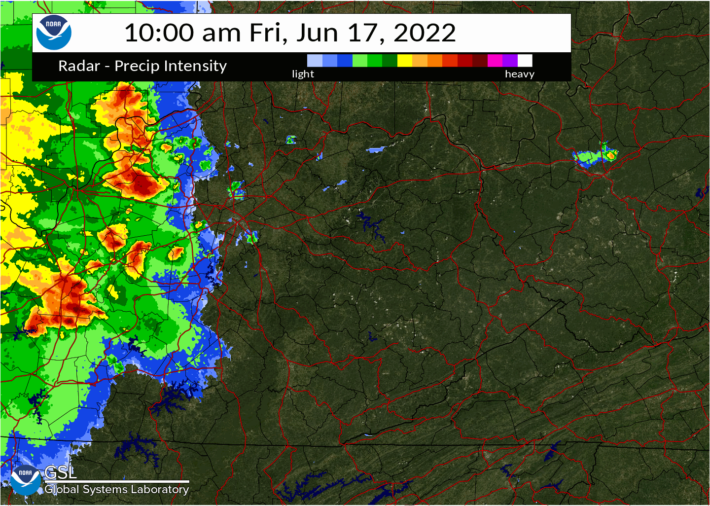
Late on June 16th to early on June 17th, severe thunderstorms developed over portions of southeastern Nebraska, eastern Kansas, and Missouri as shown in Figure 1. As the overnight hours progressed, these thunderstorms merged into a complex of thunderstorms known as a mesoscale convective system (MCS). The leading edge of this system led to reports of damaging winds and a few reports of hail from across the Missouri Valley with the system continuing to produce wind damage over the mid-Mississippi Valley and as it neared the Ohio Valley around dawn on Friday the 17th.
The thunderstorms became less numerous and the system generally weakened for a time as they moved further into the Ohio Valley. However, the weakening trend was short-lived as the system encountered a very moist and unstable environment characterized by dew points in the low to mid 70s and Mixed Layer CAPE (MLCAPE) averaging 3000 to 3500 J/kg (Figure 2) over eastern Kentucky, as the high June sun angle warmed temperatures well into the 80s from near and east of the I-75 corridor. A layer of dry air in the mid-levels (evident by the Downdraft Cape (DCAPE) values greater than 900 J/kg in Figure 4) coincided with low level lapse rates increasing to 7 to 8 C/km (Figure 3) which was quite favorable for damaging winds, while high freezing levels and weaker mid level lapse rates led to low chances for severe hail. Although effective bulk shear was only marginal at near 20 knots, the instability and the system’s strong cold pool ignited organized storm development with damaging winds generally near and north of the Mountain Parkway to the Tug Fork River as well as along and south of the Hal Rogers Parkway during the early afternoon hours.
.
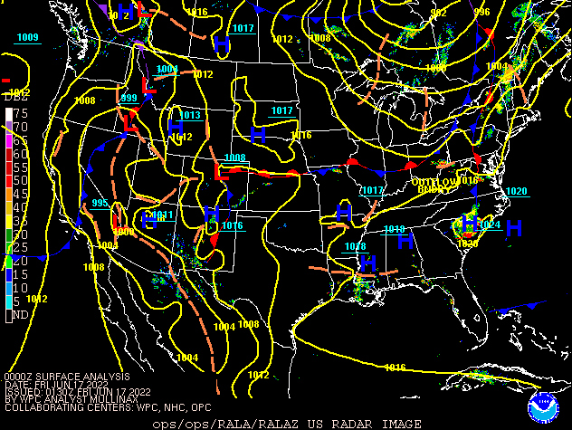 |
| Figure 1: Surface Analysis: 8 PM June 16th to 8 PM June 17th |
Near-storm environment summary.
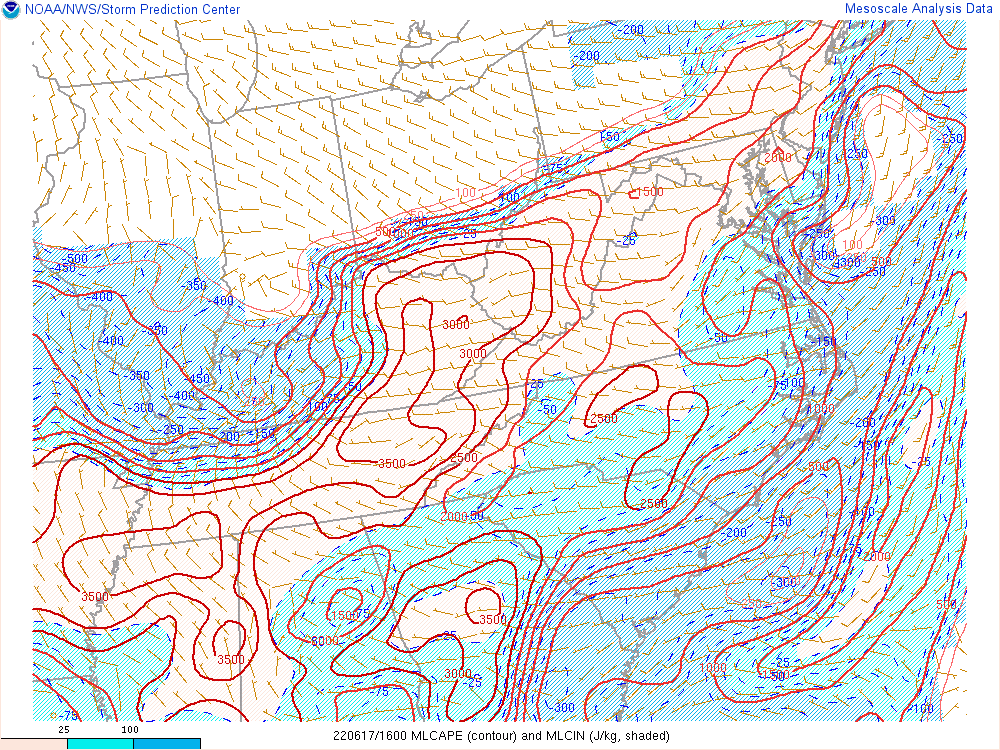 |
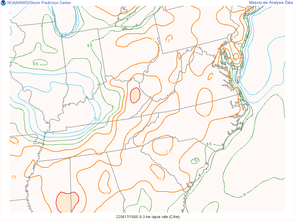 |
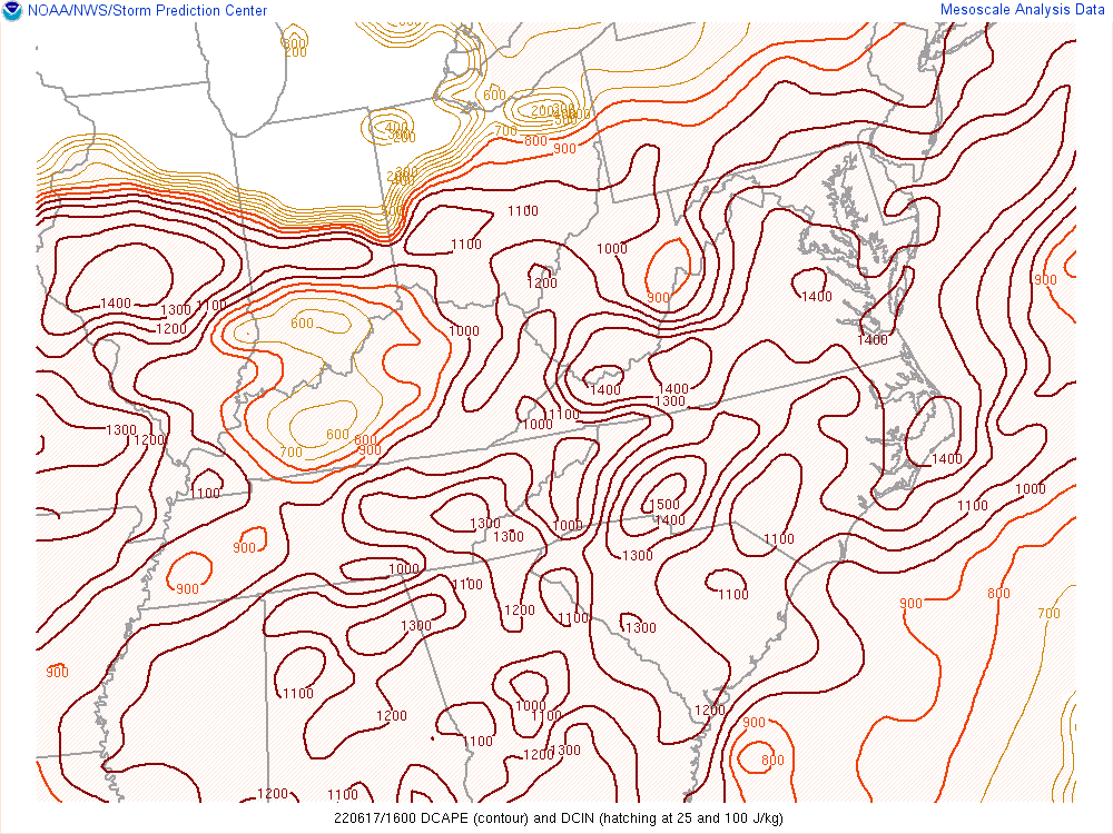 |
| Figure 2: MLCAPE at 12 PM June 17th | Figure 3: 0-3km Lapse Rates at 12 PM June 17th | Figure 4: DCAPE at 12 PM June 17th |
 |
Media use of NWS Web News Stories is encouraged! Please acknowledge the NWS as the source of any news information accessed from this site. |
|

