
High winds and very dry conditions will continue to produce elevated to critical fire weather conditions over portions of New Mexico and far western Texas through Saturday. Heavy snow will continue in the Central Rockies Heavy rain, flooding, and severe thunderstorm risks increase from the Southern Plains into the Lower Missouri Valley this weekend. Read More >
Overview
|
A complex winter storm lifted across the Southeast US on January 16th bringing with it a sloppy mess of freezing rain, rain, snow, and sleet followed by a blanket of heavy wet snow. Low pressure initially tracked from the Mississippi Valley to the Upper Tennessee Valley, where it decayed late in the evening. Meanwhile, a much stronger low developed over the Southeast US and tracked up the Atlantic Seaboard as a Nor'easter. This system initially caused a band of light snow, sleet, and freezing rain to lift northward across eastern Kentucky during the morning hours. Precipitation amounts were light but sufficient to cause slick travel in some locations. A nose of warm air aloft eventually transitioned the precipitation over to mainly rain or freezing rain for most locations by midday, as temperatures nudged to near or above the freezing mark. For much of the late morning through mid to late afternoon, strong shadowing from the Great Smoky Mountains/Southern Appalachians, kept the precipitation light and showery in nature. Eventually, cooler air filtered in aloft and eroded the remnant warm nose enough to allow the precipitation to transition back over to just snow. As this occurred, most of the precipitation became confined to a narrow but intense snow band that set up near I-75 and the Daniel Boone National Forest during the later afternoon and evening. Under this band, snowfall rates reached 1-2 inches per hour and piled up a quick 5 to 9 inch of accumulation of heavy wet snow, leading to thousands of power outages from McCreary and Whitley counties northward to Menifee County. Meanwhile, counties to the east missed out with just some showery light precipitation. As the evening wore on, the band of heavy, wet snow slowly shifted eastward and split up into multiple weaker bands -- still heavy enough to leave a 2 to 5 inch blanket of bough-bending wet snow in most locations, transforming the gray winter landscape into a snowy wonderland. The deeper valley locations of Knott, and Floyd counties, including the cities of Prestonsburg and Hindman, missed out on most of this activity, only receiving 1 to 2 inches. |
 Fresh Snowfall in Fogertown, Clay County (Courtesy of Cassidy Hensley) |
Snowfall Amounts
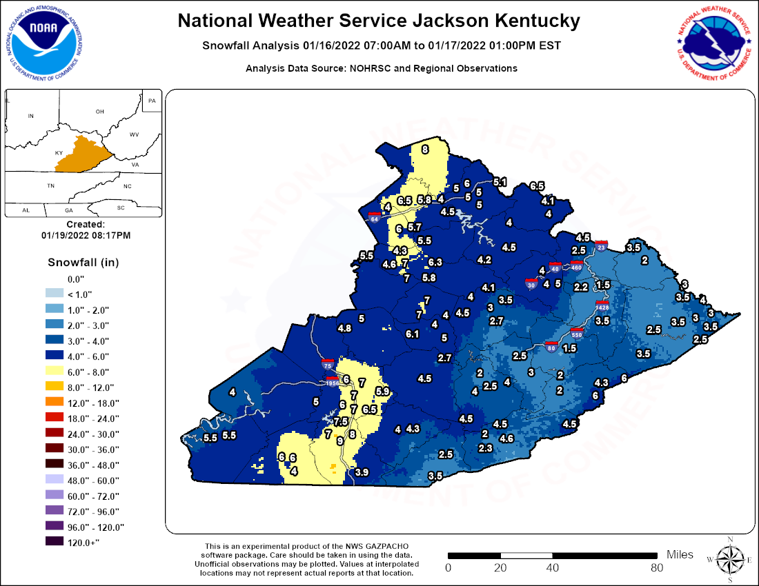
Storm Total Snowfall Reports (Sorted By County)
Location                     Amount    Time/Date       Lat/Lon

Bath County
1 W Owingsville              6.5 in    0900 PM 01/16   38.14N/83.78W
1 NNW Owingsville            5.8 in    0800 AM 01/17   38.14N/83.76W
1 NNE Polksville             4.0 in    0855 PM 01/16   38.15N/83.65W

Bell County
Beverly                      4.5 in    1038 AM 01/17   36.93N/83.53W
1 E Middlesboro              3.5 in    0945 AM 01/17   36.61N/83.70W
1 N Ponza                    2.5 in    0945 AM 01/17   36.73N/83.64W

Breathitt County
1 ESE Athol                  4.5 in    1000 AM 01/17   37.55N/83.56W
1 S Paxton                   4.1 in    0700 AM 01/17   37.66N/83.41W
Lawson                       4.0 in    1000 AM 01/17   37.60N/83.46W
NWS Office/Julian Carroll Ap 3.5 in    0700 AM 01/17   37.59N/83.32W
1 NNE Quicksand              3.0 in    1000 AM 01/17   37.54N/83.34W
Inverness                    2.7 in    1100 AM 01/17   37.53N/83.36W

Clay County
Manchester                   4.5 in    0945 AM 01/17   37.15N/83.76W
Oneida                       2.7 in    0715 AM 01/17   37.27N/83.65W

Elliott County
3 N Stark                    6.5 in    0920 AM 01/17   38.22N/83.14W
3 ENE Stark                  4.1 in    0900 AM 01/17   38.19N/83.08W
Isonville                    4.0 in    0920 AM 01/17   38.07N/83.05W

Estill County
Cressy                       5.5 in    0800 AM 01/17   37.83N/84.04W

Fleming County
Flemingsburg                 8.0 in    0930 AM 01/17   38.42N/83.74W

Floyd County
1 W Minnie                   3.5 in    0815 AM 01/17   37.47N/82.78W
Emma                         2.5 in    0630 AM 01/17   37.63N/82.70W
2 ENE Dotson                 2.2 in    0100 PM 01/17   37.66N/82.83W
2 ENE Dotson                 1.9 in    0700 AM 01/17   37.66N/82.83W
Prestonsburg                 1.5 in    0538 PM 01/17   37.67N/82.77W
1 NE Dwale                   1.3 in    0930 AM 01/17   37.63N/82.72W

Harlan County
1 NNE Gatun                  4.6 in    0724 AM 01/17   36.88N/83.31W
1 W Rock House               4.5 in    0945 AM 01/17   36.90N/82.96W
2 SE Bledsoe                 4.5 in    0945 AM 01/17   36.90N/83.34W
Dressen                      2.3 in    0600 AM 01/17   36.83N/83.33W
Fresh Meadows                2.0 in    0945 AM 01/17   36.84N/83.37W

Jackson County
Green Hall                   6.1 in    0827 PM 01/16   37.40N/83.83W
Sandgap                      5.0 in    0735 PM 01/16   37.49N/84.09W
2 NNW Loam                   4.8 in    0800 AM 01/17   37.43N/84.14W

Johnson County
Flatgap                      4.5 in    1000 AM 01/17   37.93N/82.89W
2 NNW Staffordsville         2.5 in    1000 AM 01/17   37.86N/82.86W

Knott County
2 SE Hindman                 1.5 in    0920 AM 01/17   37.32N/82.96W

Knox County
Bimble                       4.3 in    1045 AM 01/17   36.88N/83.83W
Barbourville                 4.0 in    0945 AM 01/17   36.87N/83.88W

Laurel County
3 W Sublimity City           7.0 in    1057 PM 01/16   37.09N/84.14W
1 NNW North Corbin           7.0 in    0404 AM 01/17   36.98N/84.10W
London                       7.0 in    0113 PM 01/17   37.13N/84.08W
1 S Lily                     6.5 in    0812 AM 01/17   37.01N/84.07W
1 ESE Bernstadt              6.0 in    0842 PM 01/16   37.15N/84.17W
Keavy                        6.0 in    0848 PM 01/16   37.00N/84.16W
Lesbas                       5.9 in    0931 PM 01/16   37.08N/84.00W
1 S Lesbas                   5.8 in    0931 PM 01/16   37.06N/84.00W

Lee County
1 WNW Beattyville            7.0 in    0851 AM 01/17   37.59N/83.73W
Corgleton                    7.0 in    1000 AM 01/17   37.55N/83.71W

Leslie County
1 N Essie                    4.0 in    0945 AM 01/17   37.08N/83.46W
Smilax                       4.0 in    0945 AM 01/17   37.13N/83.28W
2 WNW Hyden                  2.5 in    0945 AM 01/17   37.17N/83.40W
Thousandsticks               2.0 in    0655 AM 01/17   37.19N/83.43W

Letcher County
1 ENE Oven Fork              6.0 in    0945 AM 01/17   37.06N/82.80W
1 E Payne Gap                6.0 in    0945 AM 01/17   37.16N/82.64W
Colly                        4.3 in    0945 AM 01/17   37.13N/82.78W
Lilley Cornett Woods         2.0 in    0700 AM 01/17   37.09N/82.99W
Carcassonne                  2.0 in    0900 AM 01/17   37.17N/82.99W

Magoffin County
Bradley                      5.0 in    0920 AM 01/17   37.71N/83.01W
Salyersville                 4.0 in    1228 AM 01/17   37.75N/83.06W
1 S Salyersville             4.0 in    0801 AM 01/17   37.74N/83.07W

Martin County
1 WNW Inez                   3.5 in    0830 AM 01/17   37.87N/82.56W
1 ENE Inez                   2.0 in    0700 AM 01/17   37.87N/82.52W

McCreary County
Whitley City                 6.0 in    1135 AM 01/17   36.72N/84.48W
1 SSE Whitley City           6.0 in    1135 AM 01/17   36.72N/84.47W
1 SSE Whitley City           5.0 in    0200 AM 01/17   36.72N/84.47W
1 ENE Stearns                4.0 in    1045 AM 01/17   36.70N/84.46W

Menifee County
Means                        5.5 in    1111 PM 01/16   37.95N/83.77W

Montgomery County
1 NW Jeffersonville          6.0 in    0928 PM 01/16   37.98N/83.85W
1 S Oggs Station             5.7 in    0230 AM 01/17   38.01N/83.82W
2 WNW Jeffersonville         5.5 in    0927 PM 01/16   37.98N/83.85W
1 NW Ewington                4.0 in    0730 AM 01/17   38.10N/83.92W

Morgan County
Greear                       4.5 in    0920 AM 01/17   37.88N/83.30W
Wrigley                      4.0 in    0945 PM 01/16   38.02N/83.27W

Owsley County
Gobbard                      5.0 in    1045 AM 01/17   37.38N/83.63W
2 NNW Lerose                 4.0 in    0700 AM 01/17   37.50N/83.62W
Turin                        4.0 in    1045 AM 01/17   37.45N/83.68W

Perry County
Viper                        3.0 in    0613 PM 01/17   37.19N/83.15W
3 NW Hazard                  2.5 in    0920 AM 01/17   37.28N/83.24W

Pike County
3 SE Hardy                   4.0 in    0800 AM 01/17   37.59N/82.20W
Canada                       3.5 in    0800 AM 01/17   37.60N/82.33W
2 ENE Dorton                 3.5 in    0800 AM 01/17   37.29N/82.55W
2 NW Phyllis                 3.5 in    1000 AM 01/17   37.47N/82.36W
3 S Coleman                  3.5 in    1000 AM 01/17   37.44N/82.18W
1 NE Turkey Creek            3.0 in    0600 AM 01/17   37.68N/82.30W
1 NNE Phelps                 3.0 in    1000 AM 01/17   37.52N/82.15W
3 W Coleman                  3.0 in    1000 AM 01/17   37.49N/82.24W
Shelbiana                    2.5 in    0800 AM 01/17   37.42N/82.49W
Fedscreek                    2.5 in    1000 AM 01/17   37.40N/82.24W

Powell County
1 SSE Stanton                7.0 in    1030 PM 01/16   37.83N/83.85W
1 NNW Furnace                7.0 in    1050 PM 01/16   37.77N/83.84W
1 NNE Slade                  6.3 in    1155 PM 01/16   37.80N/83.70W
2 WSW Slade                  5.8 in    1037 PM 01/16   37.77N/83.74W
2 ESE Clay City              4.6 in    1100 PM 01/16   37.85N/83.90W
Waltersville                 4.6 in    0800 AM 01/17   37.87N/83.93W
2 E Clay City                4.3 in    0800 PM 01/17   37.86N/83.90W

Pulaski County
2 WNW Rockcastle Springs     5.0 in    0700 AM 01/17   37.02N/84.34W
1 NE Faubush                 4.0 in    0327 PM 01/17   37.08N/84.81W

Rowan County
Hilda                        6.0 in    0928 AM 01/17   38.24N/83.51W
1 ENE Gates                  5.1 in    0659 AM 01/17   38.24N/83.34W
Hilda                        5.0 in    0940 PM 01/16   38.24N/83.51W
Morehead                     5.0 in    1000 PM 01/16   38.19N/83.44W
Morehead                     5.0 in    1000 PM 01/16   38.19N/83.44W
1 SSE Morehead               5.0 in    1005 PM 01/16   38.18N/83.44W
2 SSE Farmers                4.5 in    0700 AM 01/17   38.12N/83.53W

Wayne County
1 S Monticello               5.5 in    1130 PM 01/16   36.83N/84.85W
Monticello                   5.5 in    1137 PM 01/16   36.84N/84.85W

Whitley County
1 SSW Deering                9.0 in    0700 AM 01/17   36.87N/84.21W
1 NW Faber                   8.0 in    1159 AM 01/17   36.89N/84.14W
1 S Barton                   7.5 in    1029 PM 01/16   36.92N/84.13W
2 SE Youngs Creek            7.0 in    0814 AM 01/17   36.85N/84.22W
Corbin                       7.0 in    0945 AM 01/17   36.94N/84.11W
Saxton                       3.9 in    0807 PM 01/16   36.63N/84.11W

Wolfe County
1 SSW Murphyfork             4.2 in    0951 AM 01/17   37.81N/83.43W

Observations are collected from a variety of sources with varying
equipment and exposures. We thank all volunteer weather observers
for their dedication. Not all data listed are considered official.
Photos
 |
 |
 |
 |
| Heavy Wet Snow in Laurel County (Courtesy of Twitter) |
Snowy Night in Perry County (Courtesy of Twitter) |
Laurel Lake from the KY-312 Bridge (Courtesy of Katie Greene) |
Wintry KY-1071 in Jackson County (Courtesy of Matt Thomas) |
 |
 |
 |
 |
| Winter Wonderland in Morehead (Courtesy of Jeremy Tombs) |
Snow-Rimmed Lake in Nancy (Courtesy of Amanda Cox) |
Winter Wonderland South of London (Courtesy of Johnnie Nicholson) |
Wintry Evening near Pine Knot (Courtesy of Cari King) |
Radar
 |
| Radar Loop From 1 AM January 16th through 3 AM January 17th |
Environment
A complex low pressure system moved eastward from the Lower Mississippi Valley on January 15th. The primary low became lodged along the western slopes of the Southern Appalachians and weakened on January 16th. Meanwhile, a new low consolidated along the Southeast US and then rapidly deepened as it moved up the Atlantic Seaboard.
 |
| Figure 1: Surface Analysis from 7 AM January 15th through 7 AM January 17th |
While there were many moving parts to this system, the most impactful winter weather occurred during the evening of the 16th when several factors came together and produced a narrow, but intense, band of snow across portions of eastern Kentucky. Figure 2 shows the upper level heights, winds, and divergence. At 5 PM, an 120-140 knot jet streak was analyzed along the Southeast Coast northward into the Carolinas. This placed eastern Kentucky in a favored left exit region, leading to strong divergence (magenta contours). Meanwhile, very moist air was wrapping around a closed low in the mid-levels of the atmosphere as shown in Figure 3. This moisture fueled a semi-stationary snow band which developed due to a zone of strong compression in the mid-levels (see Figure 4). This was the band that dropped the swath of heavy, wet snow from Whitley and McCreary counties northward to Fleming County. Later in the evening, the band started shifting to the east, but also became weaker and disorganized, with the loss of better upper level support for upward motions. Consequently, snowfall generally diminished with eastward extent, although a slight increase in the snowfall was noted in the higher terrain of southeast Kentucky, perhaps due to upslope enhancement.
 |
 |
 |
| Figure 2: 300 mb Analysis | Figure 3: 700 mb Analysis | Figure 4: 500 mb Analysis |
 |
Media use of NWS Web News Stories is encouraged! Please acknowledge the NWS as the source of any news information accessed from this site. |
|

