Severe thunderstorms are forecast through this weekend along a slow moving cold front and secondary storm system that will impact areas from the southern Plains to the Great Lakes. Large hail and isolated damaging wind gusts are the main threats with these storms along with a risk for heavy to excessive rainfall which could bring flooding. Read More >
Overview
|
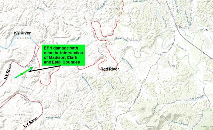
The second warmest December on record for Eastern Kentucky finished with a warm and moist air mass in place on New Year's Eve. A developing warm front slowly lifted northward out of the Tennessee Valley during the early morning hours on New Year's Day 2022 and stalled near the the Hal Rogers/Highway 80 corridor. The combination of strong lifting and near record atmospheric moisture levels for this time of year led to a line of training showers and thunderstorms, some with frequent lightning and intense downpours. The heaviest rainfall occurred from about 4 to 8 AM and led to many instances of flash flooding from Rockcastle County east northeast through Jackson, Owsley, Breathitt, Floyd, and Pike counties. By midday, locations affected by this activity had received 2 to 4 inches of rainfall. A temporary lull in the showers followed as the front shifted further to the north during the late morning and early afternoon. This allowed temperatures to surge into the 60s across the northeast Kentucky and into the lower to middle 70s closer the Kentucky/Tennessee border. Strong to severe thunderstorms developed in a high shear, low instability environment during the afternoon as a cold front swept from northwest to southeast across the area. While these storms mainly produced damaging wind gusts, one storm produced a brief spinup tornado in far northwest Estill County. Impacts did not end with the passage of the cold front though; the excessive rainfall from earlier in the day quickly found its way into the mainstem rivers, sending multiple locations along the Kentucky and Red Rivers into flood stage. The most significant river flooding of the event — Moderate flood — was attained along the Kentucky River at Ravenna, the Red River at Clay City, and the South Fork Kentucky River at Booneville. A few other locations surpassed Minor flood stage. |
Tornado:
|
Tornado - near Palmer, KY
|
||||||||||||||||
The Enhanced Fujita (EF) Scale classifies tornadoes into the following categories:
| EF0 Weak 65-85 mph |
EF1 Moderate 86-110 mph |
EF2 Significant 111-135 mph |
EF3 Severe 136-165 mph |
EF4 Extreme 166-200 mph |
EF5 Catastrophic 200+ mph |
 |
|||||
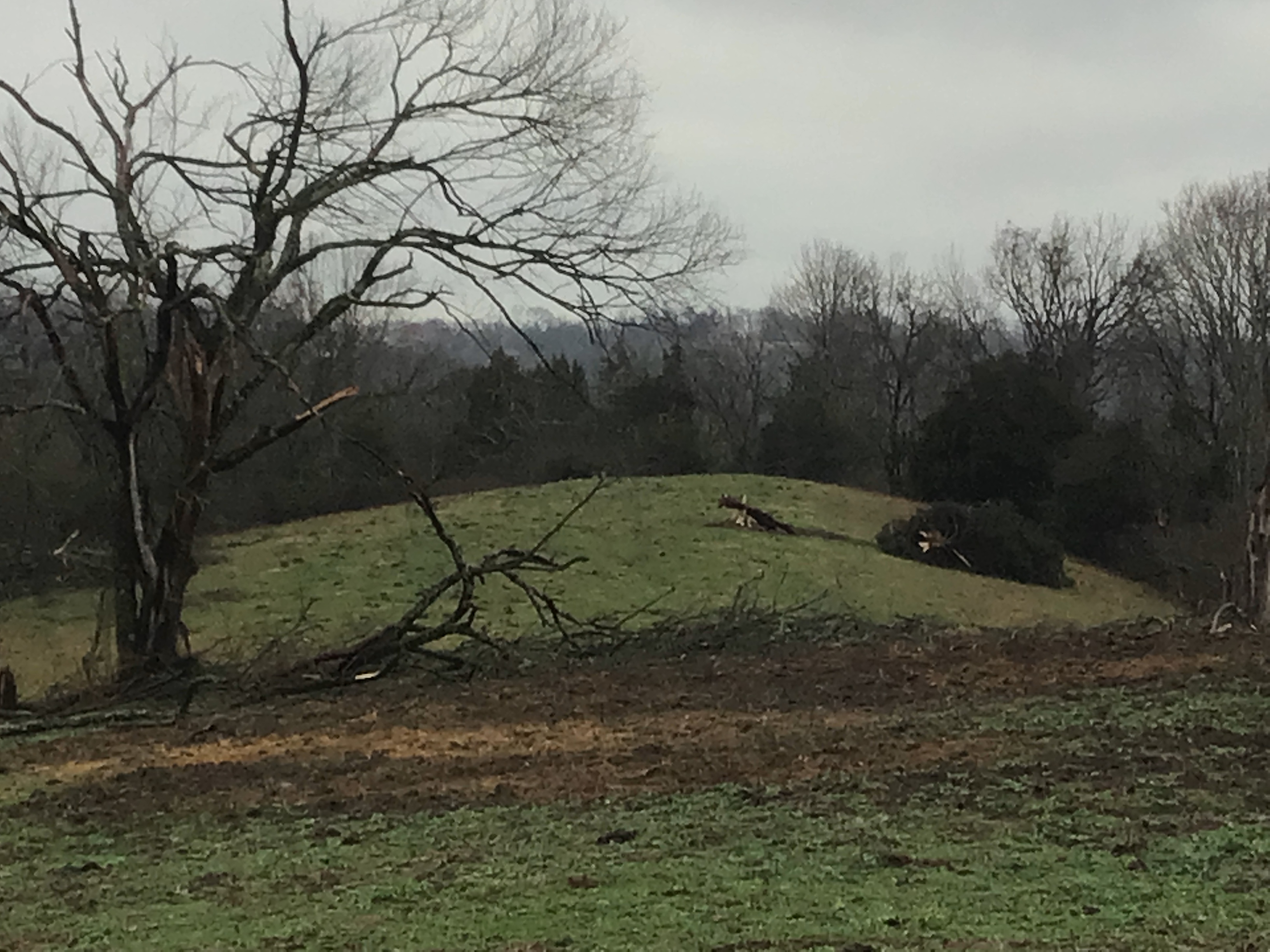
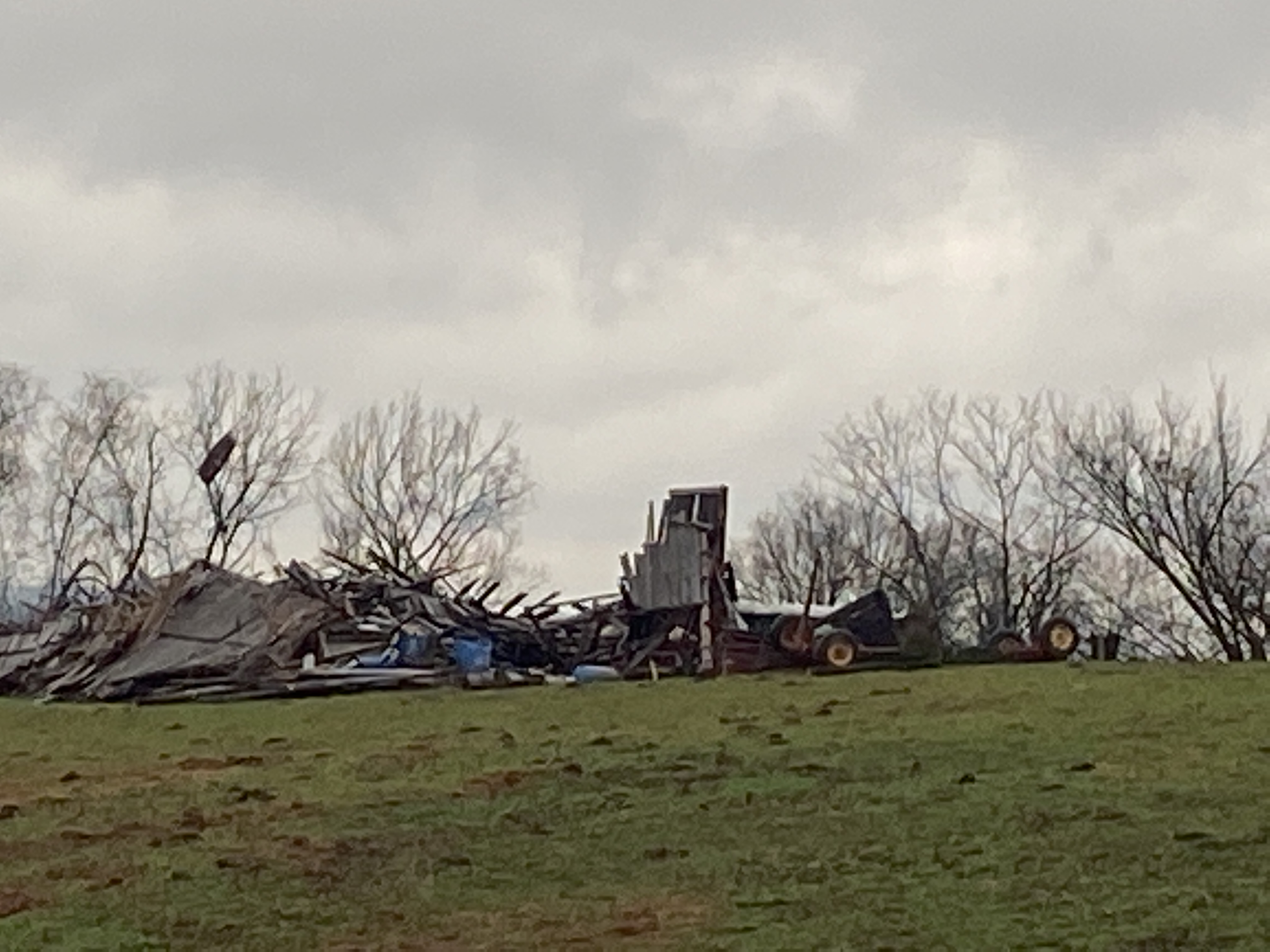
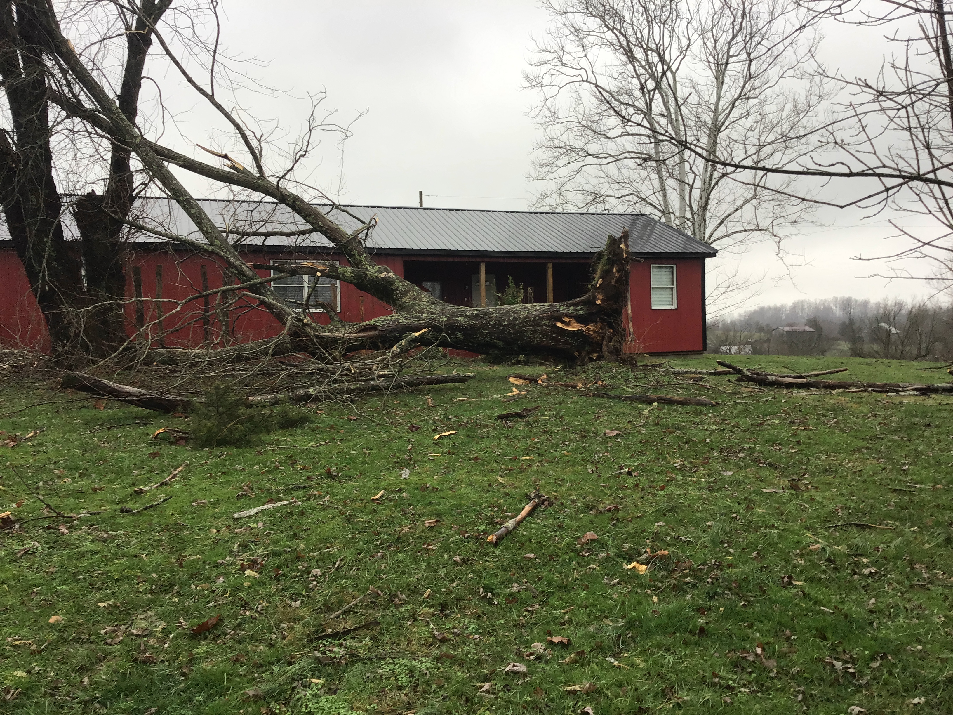
Storm Survey Pictures
 |
 |
 |
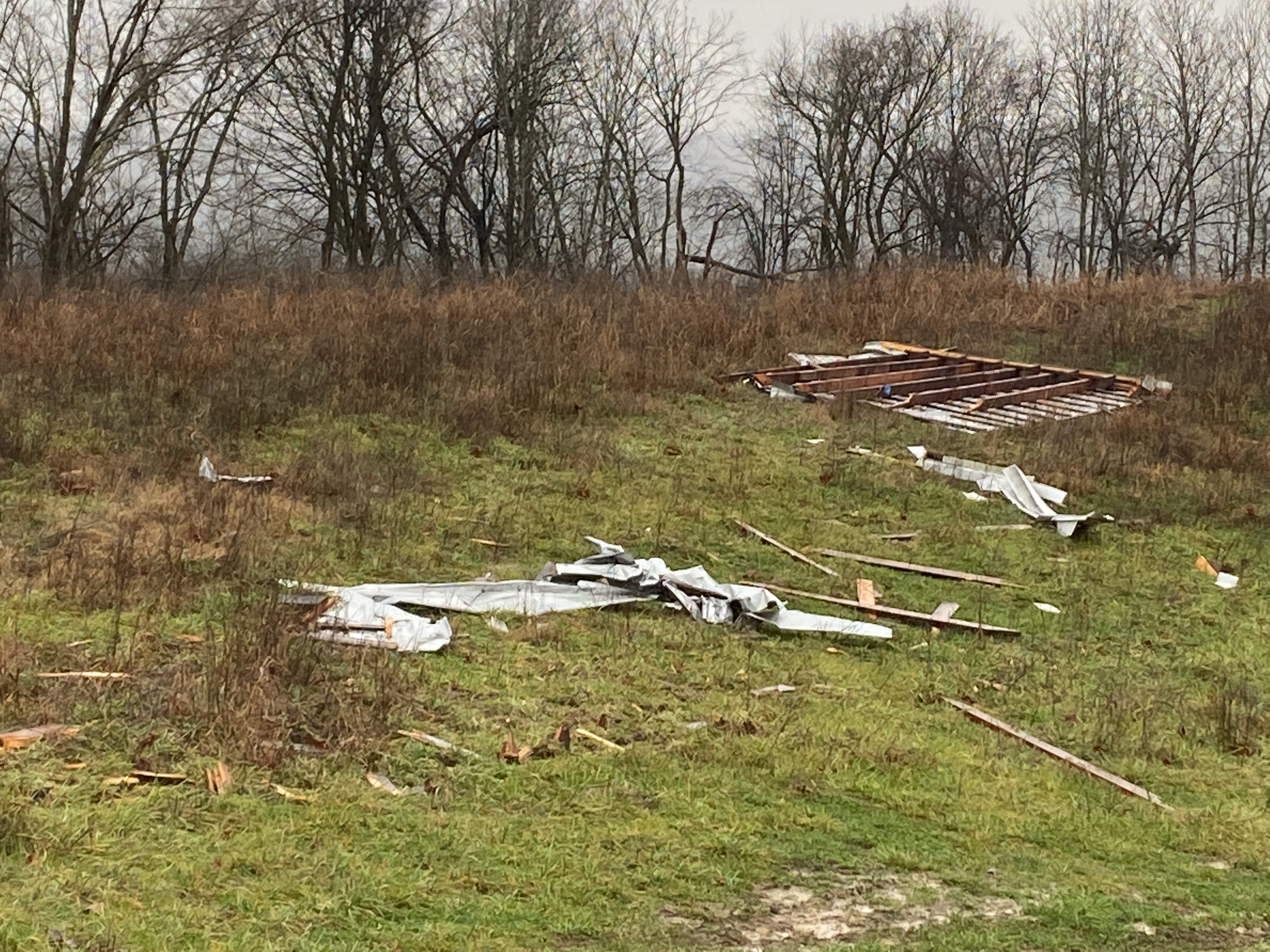 |
| Tree Damage | Destroyed Barn | Downed Tree | Roofing Strewn in a Field |
Flash Flooding
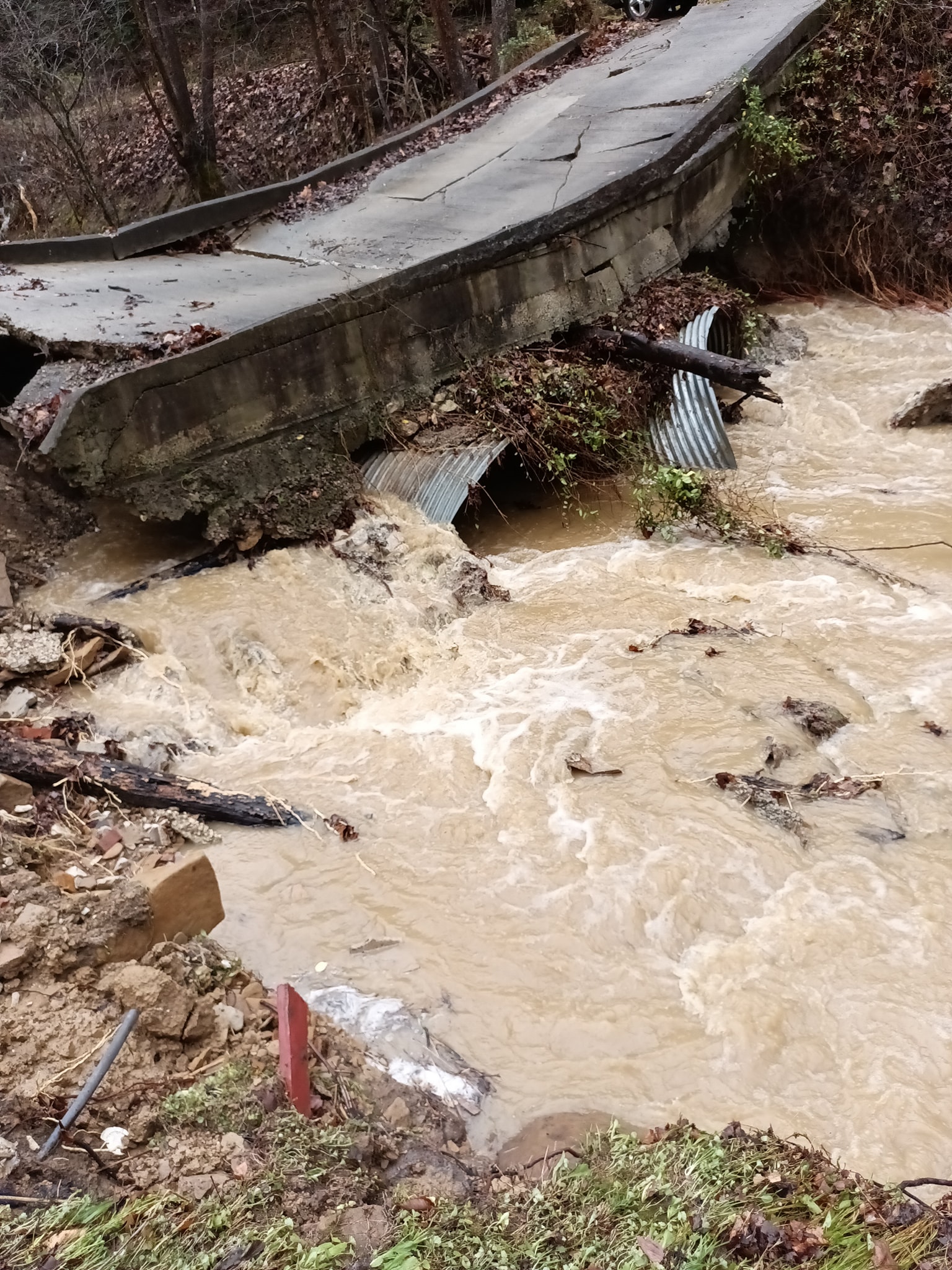
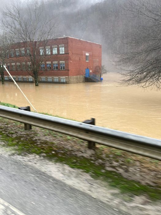
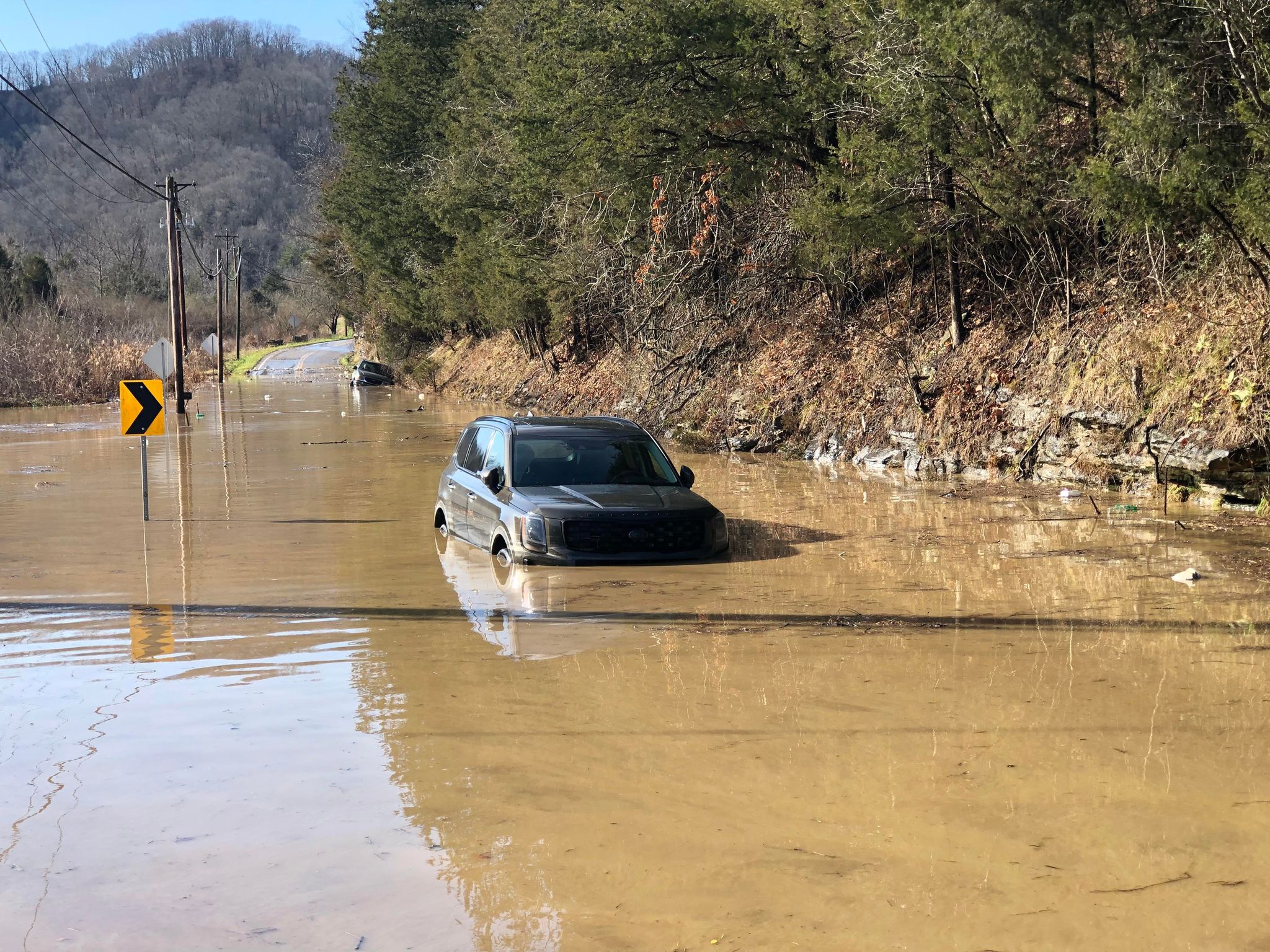
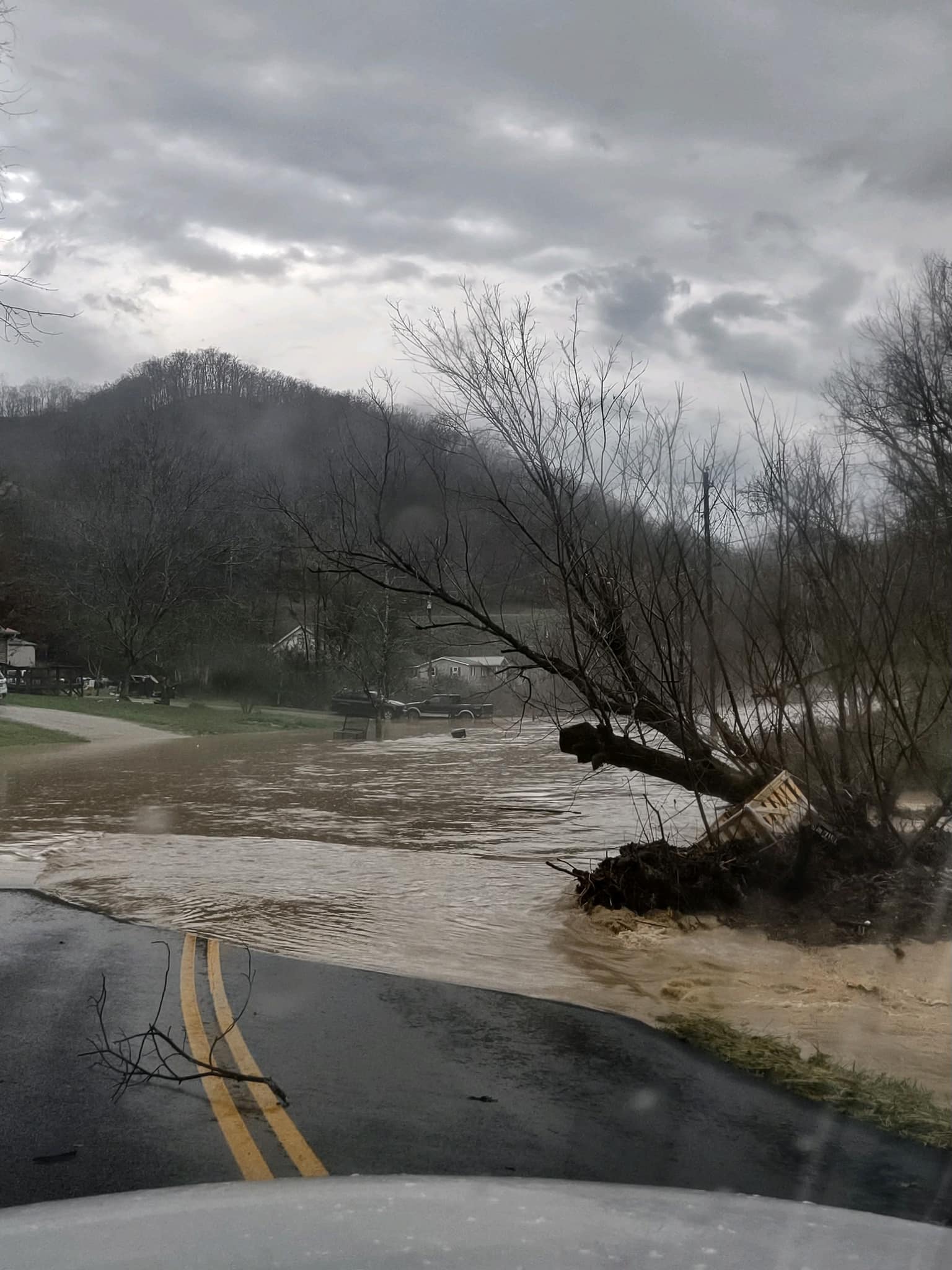
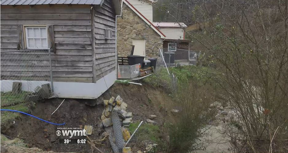
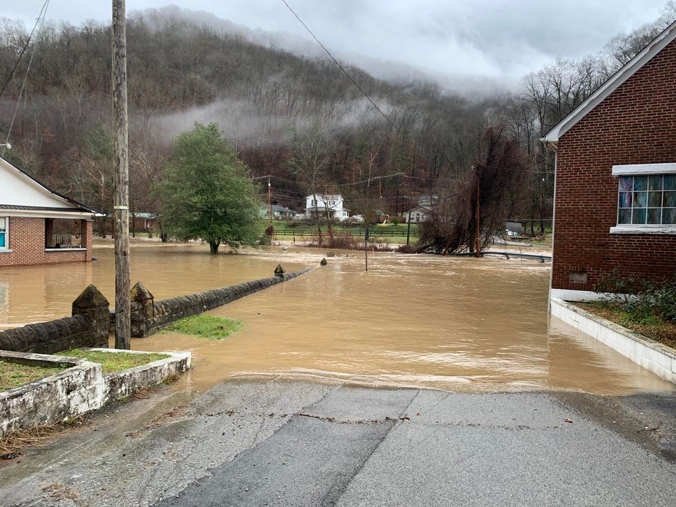
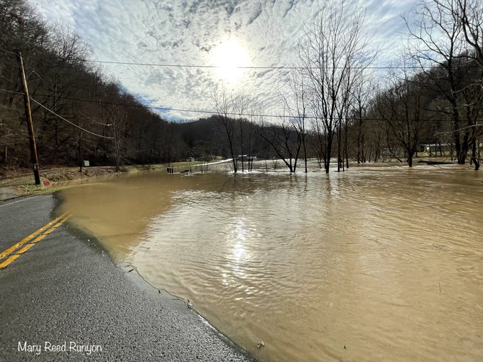
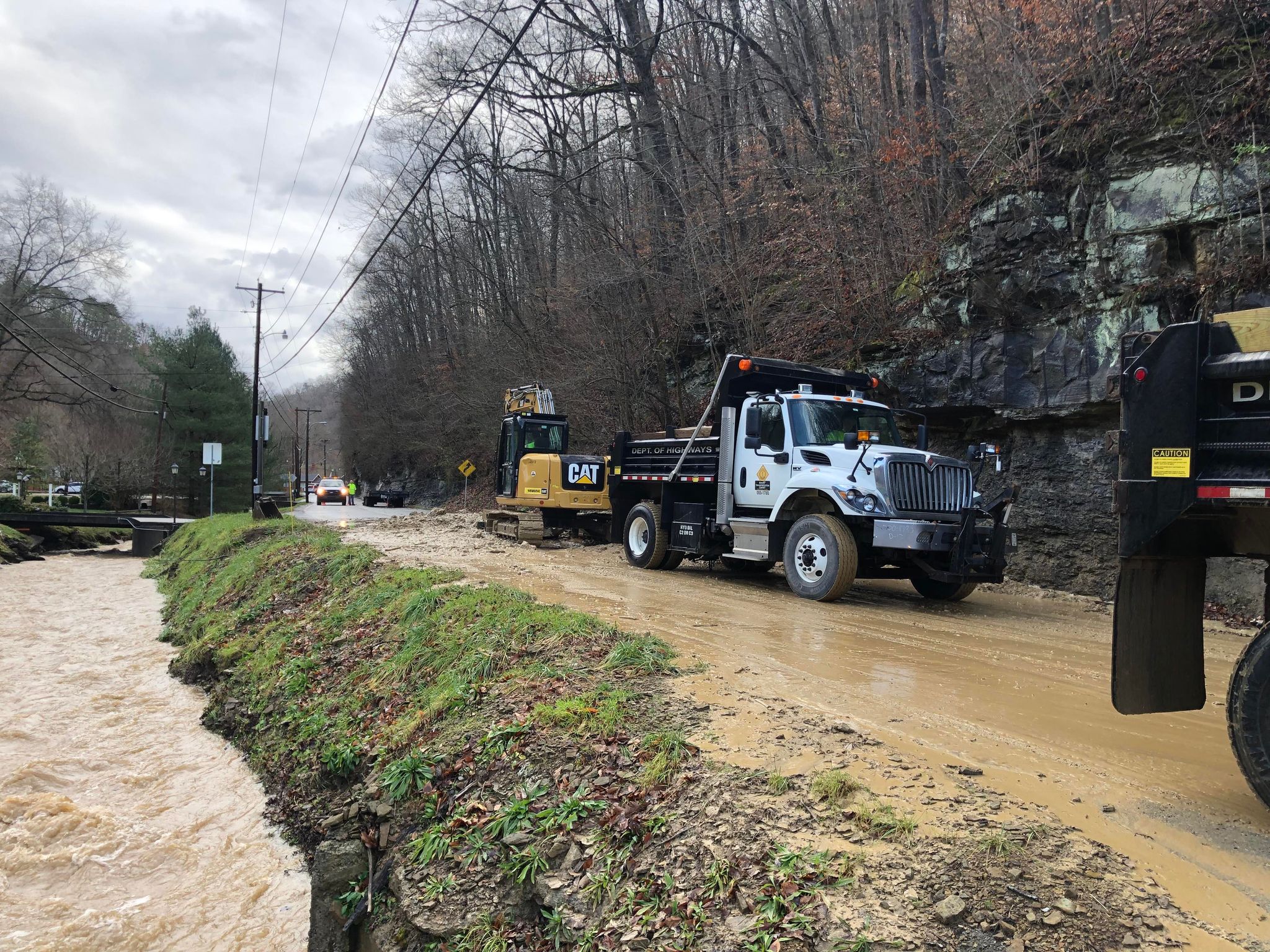
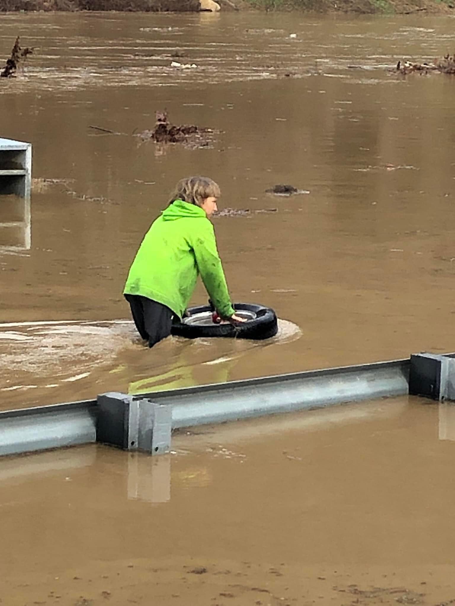
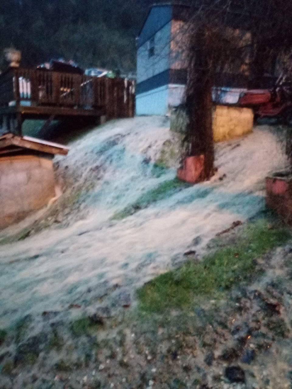
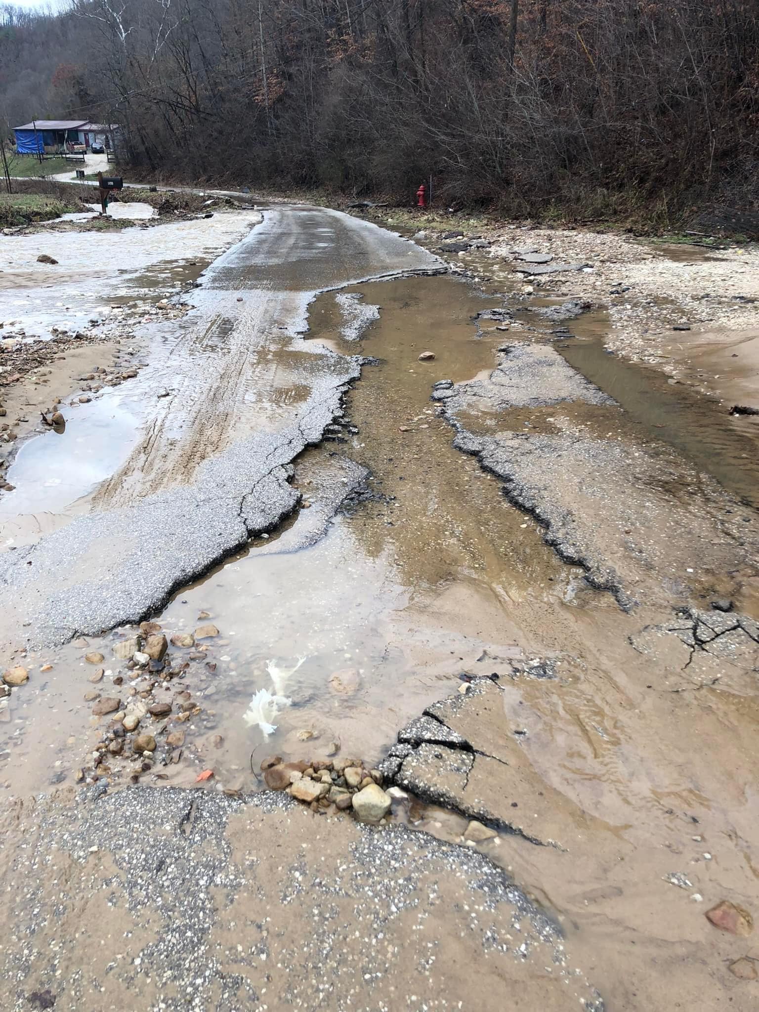
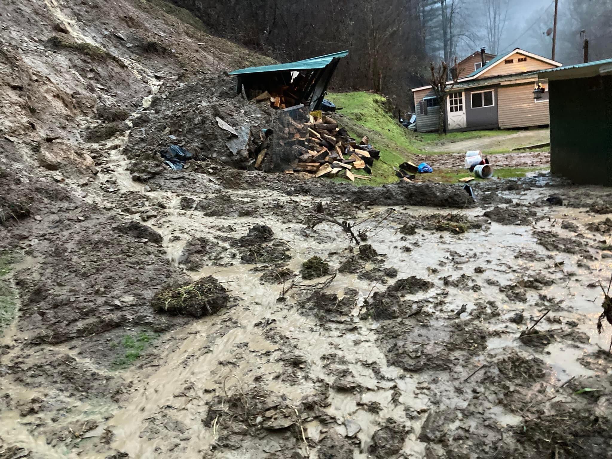
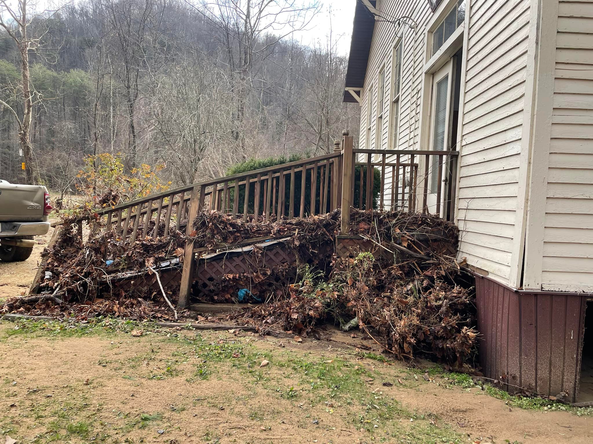
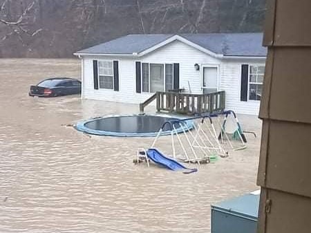
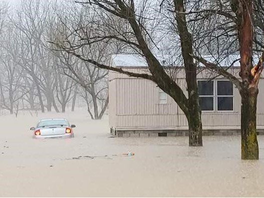
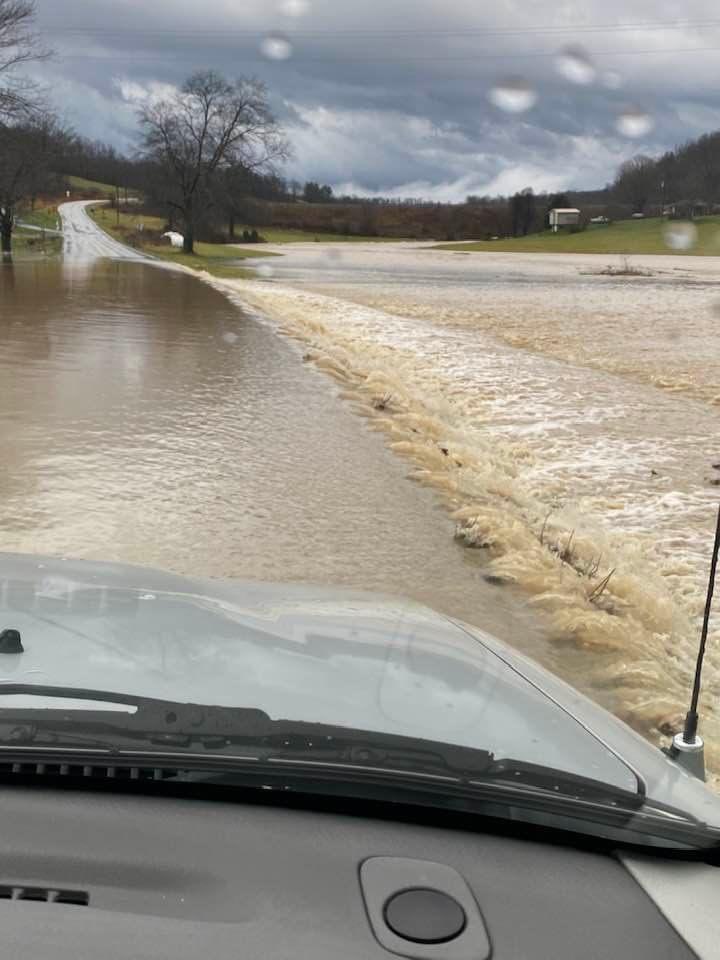
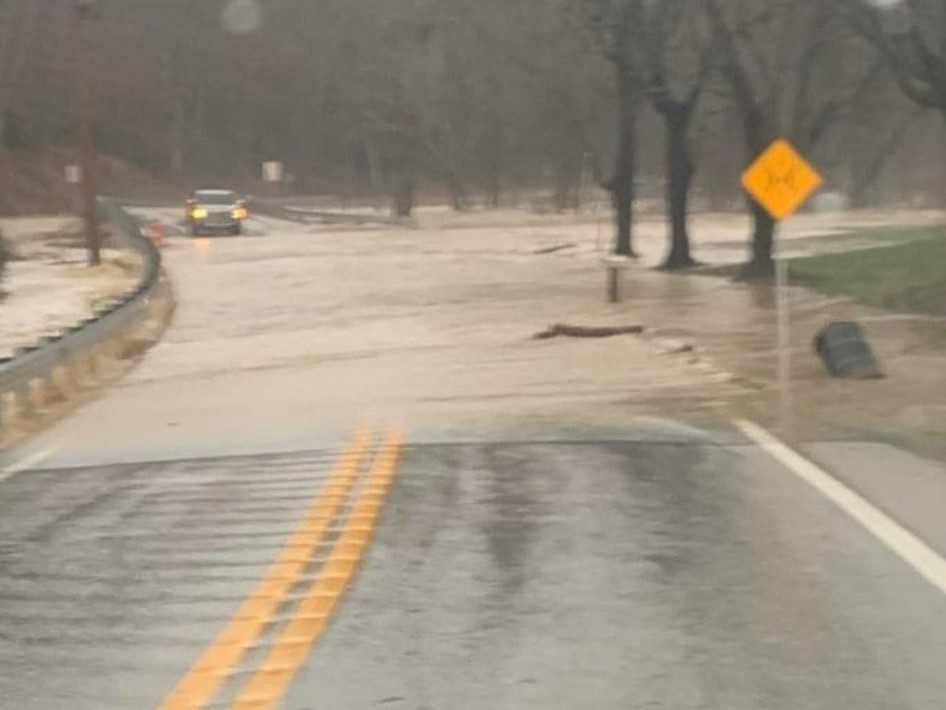
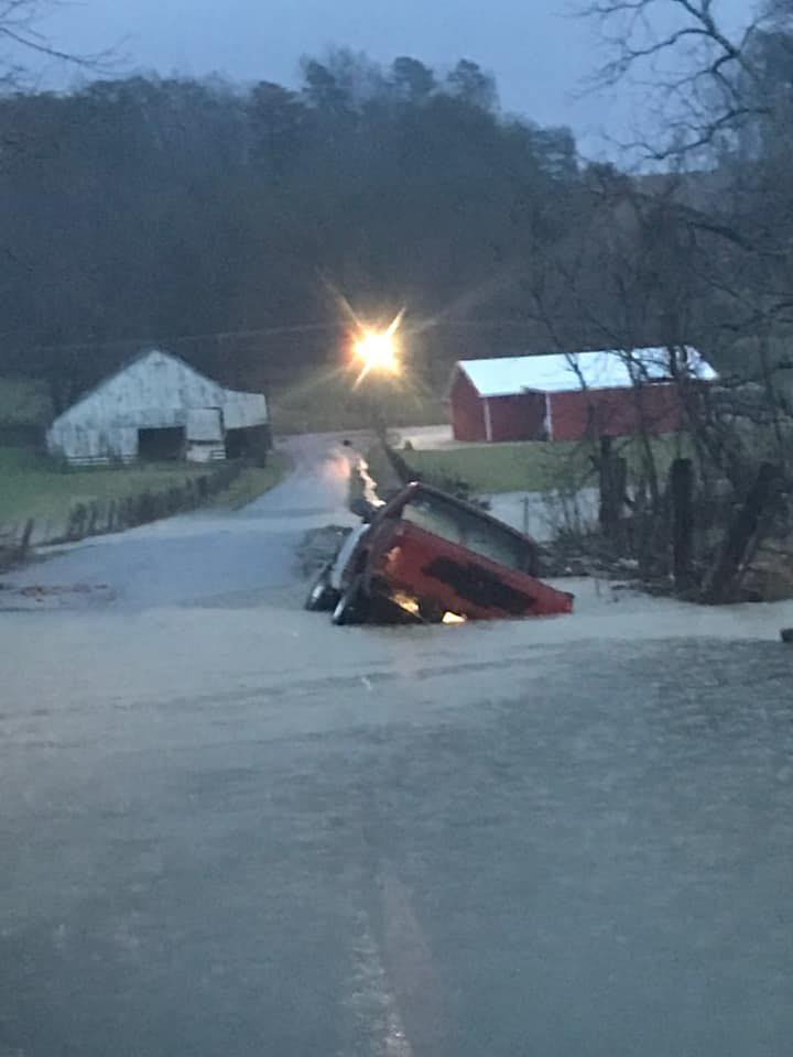
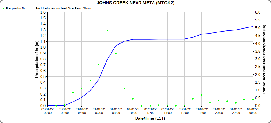
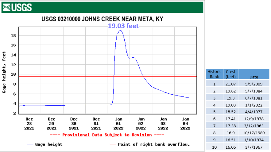
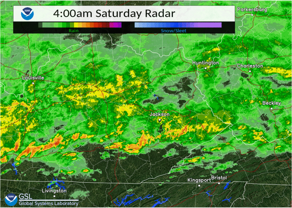
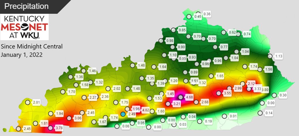
Persistent showers and intense thunderstorms quickly dropped several inches of rainfall (Figure 4) in a matter of hours from roughly along an axis from Rockcastle to Pike counties (Figure 3). All of this rain quickly ran off of the steep terrain in the valleys leading to significant flash flooding which stranded motorists, flooding homes, and severely eroding stream banks and culverts. The Canoe area of Breathitt County and the Coal Run/Meta areas of Pike County were particularly hard hit. A stream gauge along Johns Creek near Meta received over 4.25 inches within a period of 7 hours (Figure 1). Figure 2 shows the stream responded by rising 15 feet (or 9+ feet over its banks) within a 9 hour period, setting the 4th highest crest on record and the highest crest since May 9th, 2009.
Pictures
 |
 |
 |
 |
| Flooding in Meta, Pike County (Courtesy of WYMT) |
Flood Waters over KY-1426, Floyd County (Courtesy of WYMT) |
Flooded KY-777, Floyd County (Courtesy of Floyd County Sheriff) |
Severe Erosion in Coal Run, Pike County (Courtesy of WYMT) |
 |
 |
 |
.jpg) |
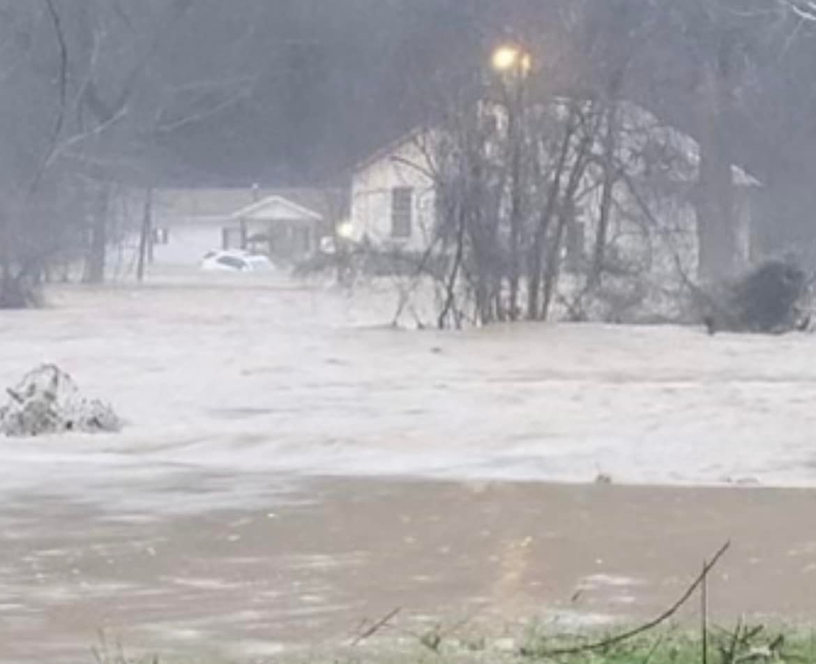
| Flash Flooding in Belfry, Pike County (Courtesy of WYMT) |
Flood Waters over KY-468,Pike County (Courtesy of Mary Runyon) |
Mudslide Repair, Pikeville (Courtesy of WYMT) |
Flash Flooding, Floyd County (Courtesy of Floyd County Sheriff) |
 |
 |
.JPG) |
 |
| Child Walking Through Flood Waters, Breathitt County (Courtesy of Aspire Appalachia) |
Extreme Runoff, Breathitt County (Courtesy of Aspire Appalachia) |
Flash Flooding along Morris Fork, Breathitt County (Courtesy of Jennifer Arrowood-Thomas) |
Flash Flood Damage, Breathitt County (Courtesy of Aspire Appalachia) |
 |
 |
 |
 |
| Mudslide on Joe Little Fork, Breathitt County (Courtesy of Johnny Ray Feltner) |
Flash Flooding Joe Little Fork, Breathitt County (Courtesy of Jennifer Arrowood-Thomas) |
Flood Damage in Canoe, Breathitt County (Courtesy of Jennifer Arrowood-Thomas) |
Flash Flooding, Breathitt County (Courtesy of Aspire Appalachia) |
 |
 |
 |
 |
| Flash Flooding, Rockcastle County (Courtesy of Jordan Smith) |
Flash Flooding, Jackson County (Courtesy of JCHS Weather Team) |
Flash Flooding, Owsley County (Courtesy of Darren Hardy) |
Flash Flooding. Rockcastle County (Courtesy of Jordan Smith) |
Extreme Rainfall and Stream Response Observed on Johns Creek near Meta, KY
 |
 |
|
Figure 1: Hourly and Accumulated Rainfall at Johns Creek near Meta on January 1st (Courtesy of USGS) |
Figure 2: Johns Creek Hydrograph near Meta and Ranking of Previous Flood Crests (Courtesy of USGS) |
Radar Loop Of Training Storms and Morning Rainfall Totals
 |
 |
|
Figure 3: Period of Heaviest Rainfall Occurred from 4 AM to 9 AM EST January 1st |
Figure 4: 11-Hour Rainfall Amounts Observed Across the Commonwealth from 1 AM to 12 PM EST January 1st (Courtesy: Kentucky Mesonet) |
River Flooding
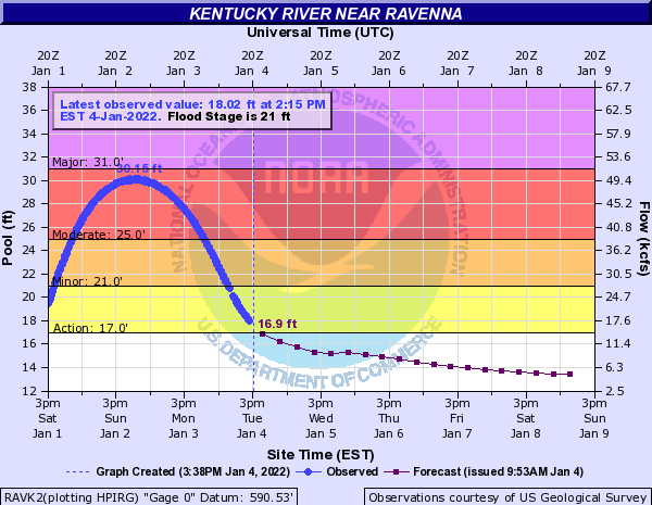
While the most disastrous flooding impacts were experienced with the flash flooding, excessive runoff into the mainstem rivers, especially the Kentucky and Red, caused stages to rise significantly. The Kentucky River at the Ravenna gauge topped out at 30.15 feet, a mere 0.85 feet below Major flood stage. This was the highest crest since the March 3rd, 2021 when the river reached 41 feet and shattered the prior crest of record. The Red River at Clay City crested at 20.33 feet or 2.67 feet below Major flood stage. This was the highest crest since March 1st, 2021 when the river peaked at 25.69 feet. Even so, roads were impassable due to flooding in the Clay City area and some homes in low-lying areas experienced high water issues. The third site, Booneville along the South Fork of the Kentucky River, briefly eclipsed Moderate flood stage by several inches. While not as significant, the Tug Fork at Williamson and Kentucky River at Heidelberg also reached Minor flood stage.
Hydrographs
 |
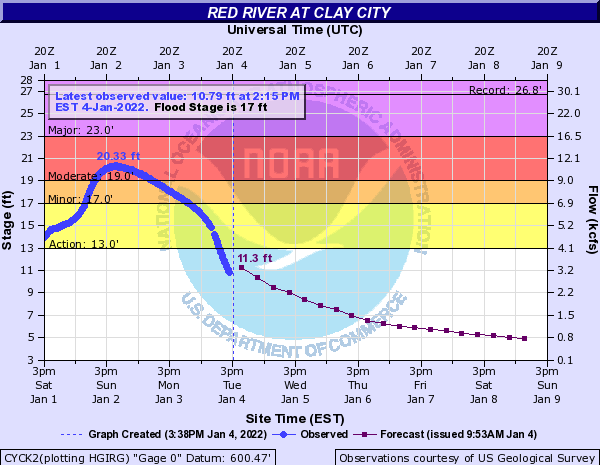 |
| Figure 1: Kentucky River Hydrograph near Ravenna | Figure 2: Red River Hydrograph near Clay City |
Radar
 |
| Event Radar Loop from 7 PM Friday, December 31st through 7 AM Sunday, January 2nd |
Rain Reports
48-Hour Rainfall Amounts Ending Sunday Morning January 2nd, 2022 (Sorted by County)
Location Amount Time/Date Lat/Lon
Bath County
4 S Owingsville 2.08 in 0700 AM 01/02 38.09N/83.76W
1 NNW Owingsville 1.48 in 0800 AM 01/02 38.14N/83.76W
Bell County
Yellow Creek RAWS 1.74 in 0700 AM 01/02 36.60N/83.70W
Middlesboro-Bell County AP 1.62 in 0700 AM 01/02 36.61N/83.74W
Breathitt County
14 ESE Jackson 4.80 in 0700 AM 01/02 37.46N/83.16W
14 SE Jackson 4.27 in 0700 AM 01/02 37.43N/83.18W
NWS Office/Julian Carroll AP 3.55 in 0700 AM 01/02 37.59N/83.31W
9 SE Campton 3.24 in 0700 AM 01/02 37.66N/83.41W
3 SE Jackson 3.21 in 0700 AM 01/02 37.54N/83.34W
Jackson Airport RAWS 2.93 in 0700 AM 01/02 37.59N/83.32W
Clay County
Oneida 3.69 in 0700 AM 01/02 37.27N/83.65W
Peabody RAWS 1.28 in 0700 AM 01/02 37.14N/83.58W
Estill County
Cressy 2.41 in 0800 AM 01/02 37.83N/84.04W
Floyd County
3 WSW Prestonsburg 3.26 in 0700 AM 01/02 37.66N/82.83W
Harlan County
24 E Harlan 2.26 in 0700 AM 01/02 36.92N/82.91W
3 N Harlan 1.52 in 0813 AM 01/02 36.88N/83.31W
Jackson County
5 S McKee 4.86 in 0700 AM 01/02 37.36N/83.97W
8 W McKee 3.85 in 0800 AM 01/02 37.43N/84.14W
Johnson County
1 E Paintsville 2.80 in 0700 AM 01/02 37.82N/82.79W
4 W Paintsville 2.76 in 0700 AM 01/02 37.83N/82.88W
Knott County
5 N Hindman 4.67 in 0700 AM 01/02 37.41N/82.99W
Carr Creek 1.82 in 0700 AM 01/02 37.23N/83.03W
Knox County
3 E Barbourville 1.20 in 0700 AM 01/02 36.87N/83.83W
Laurel County
London-Corbin Airport 1.52 in 0700 AM 01/02 37.09N/84.07W
4 S London 1.51 in 0430 AM 01/02 37.07N/84.09W
Lee County
4 N Beattyville 3.35 in 0900 AM 01/02 37.63N/83.72W
Letcher County
2 SE Whitesburg 1.78 in 0700 AM 01/02 37.10N/82.80W
Skyline 1.73 in 0700 AM 01/02 37.09N/82.99W
2 NW Whitesburg 1.54 in 0700 AM 01/02 37.13N/82.84W
Magoffin County
Salyersville 2.99 in 0800 AM 01/02 37.74N/83.07W
Martin County
2 E Inez 2.76 in 0700 AM 01/02 37.87N/82.52W
Big Sandy RAWS 2.38 in 0700 AM 01/02 37.75N/82.64W
McCreary County
3 N Whitley City 1.43 in 0700 AM 01/02 36.77N/84.48W
Montgomery County
2 W Mount Sterling 2.34 in 0730 AM 01/02 38.07N/83.99W
5 N Mount Sterling 2.15 in 0700 AM 01/02 38.13N/83.96W
Mount Sterling AP 1.86 in 0700 AM 01/02 38.06N/83.98W
Morgan County
2 SW West Liberty 3.20 in 0700 AM 01/02 37.90N/83.27W
Owsley County
2 S Booneville 4.29 in 0700 AM 01/02 37.45N/83.69W
4 ENE Booneville 3.60 in 0700 AM 01/02 37.50N/83.62W
Perry County
Buckhorn Lake 4.31 in 0700 AM 01/02 37.34N/83.47W
1 N Viper 0.59 in 0546 AM 01/02 37.19N/83.15W
Pike County
1 SE Fedscreek 2.69 in 0700 PM 01/02 37.39N/82.26W
13 S Pikeville 1.79 in 0700 AM 01/02 37.28N/82.51W
Powell County
2 W Stanton 3.14 in 0800 AM 01/02 37.86N/83.90W
1 WNW Clay City 2.87 in 0700 AM 01/02 37.87N/83.93W
Pulaski County
7 NNE Somerset 4.19 in 0700 AM 01/02 37.18N/84.56W
Somerset-Pulaski County AP 2.22 in 0700 AM 01/02 37.05N/84.61W
15 ESE Somerset 1.78 in 0700 AM 01/02 37.02N/84.34W
Rockcastle County
7 SSW Broadhead 4.52 in 0700 AM 01/02 37.30N/84.46W
Rowan County
6 NE Morehead 2.11 in 0707 AM 01/02 38.24N/83.34W
4 NE Morehead 2.05 in 0700 AM 01/02 38.22N/83.48W
Cave Run Lake 1.93 in 0700 AM 01/02 38.12N/83.53W
Triangle Mountain RAWS 1.78 in 0700 AM 01/02 38.18N/83.41W
Whitley County
7 SW Corbin 1.61 in 0700 AM 01/02 36.87N/84.21W
Wolfe County
Koomer Ridge RAWS 2.29 in 0700 AM 01/02 37.78N/83.63W
Observations are collected from a variety of sources with varying
equipment and exposures. We thank all volunteer weather observers
for their dedication. Not all data listed are considered official.
Environment
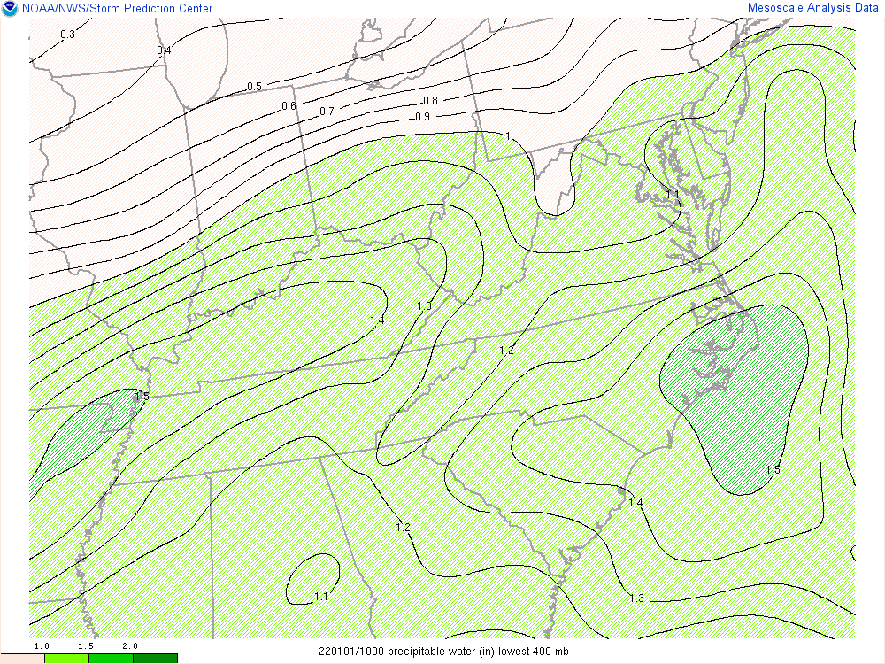
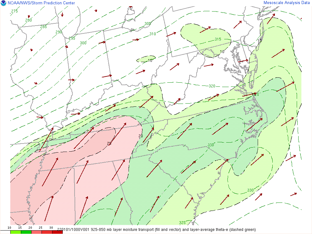
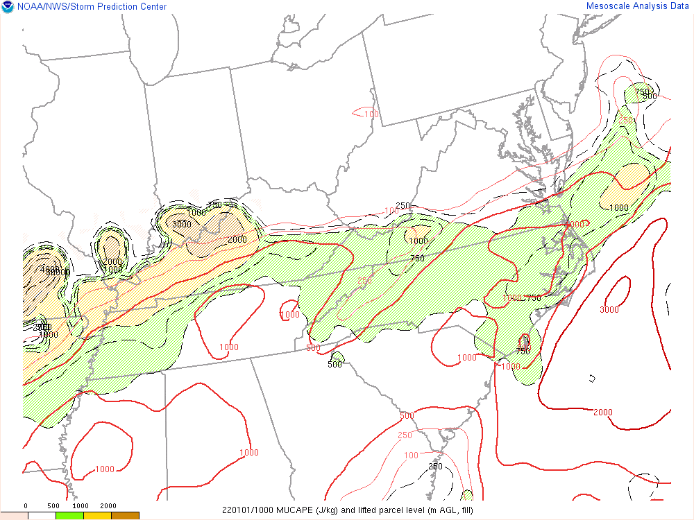
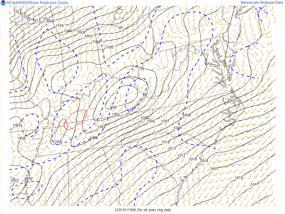
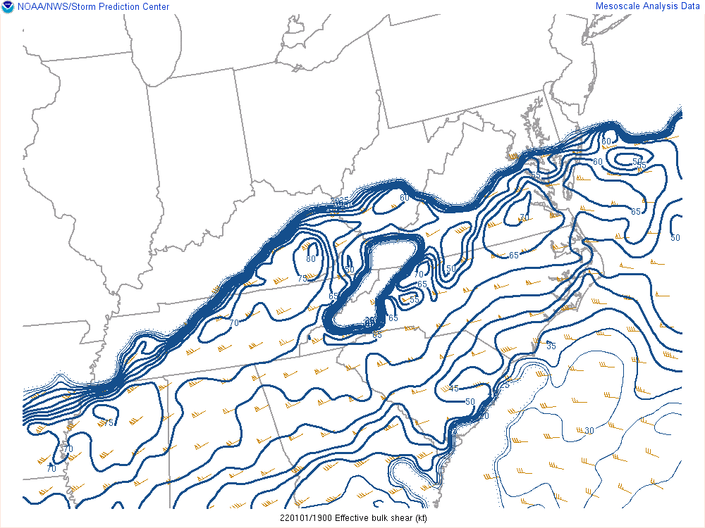
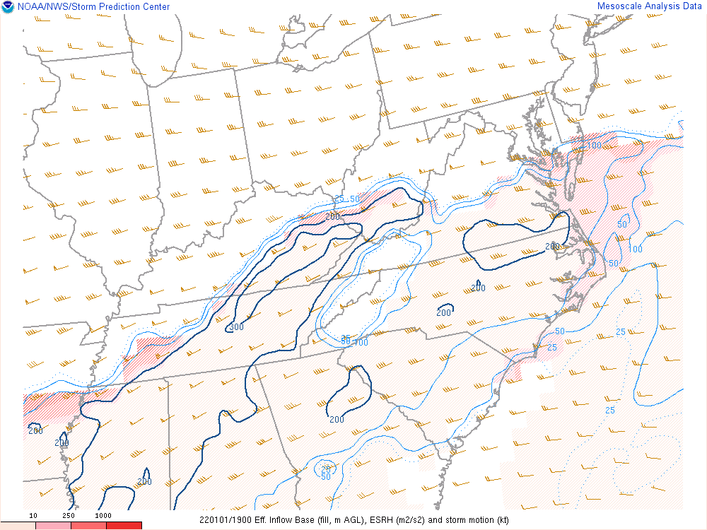
A very warm and moist air mass, by late December standards was already in place on December 31st as a frontal boundary lingered to our north over the Ohio Valley. Figure 1 shows the new warm front developing and lifting into southeast Kentucky early in the night before becoming nearly stationary New Year's morning. While rainfall was observed over the entire area, showers and strong thunderstorms with torrential rainfall became entrenched along the warm front from 4 to 9 AM. This intense activity was likely due to the combination of extremely moist tropical air mass (Figure 2) being lifted over the surface front by a powerful southwesterly jet (Figure 2). Once lifted, this air became buoyant amidst the elevated instability aloft (Figure 4), and fueled the deep convection evident on radar imagery. After a lull in the activity later in the morning, showers and storms redeveloped across Central Kentucky during the early afternoon ahead of a cold front and wave of low pressure (Figure 5). In the system's warm sector, a powerful low-level jet contributed to strong directional shear and sufficient storm relative helicity (Figure 5) for tornadogenesis. The primary limiting factor for widespread severe thunderstorms was the very weak instability, mainly under 500 J/kg on the MLCAPE analysis. In fact, the lack of lightning with most of the afternoon convection was likely due to the lack of instability. However, a relative maxima of 0-3km MLCAPE and surface vorticity (Figure 9) and the passing surface low (Figure 5) happened to coincide with passage of a stronger thunderstorm passing from Madison into Estill County. Even in the absence of notable instability, the remaining ingredients were still sufficient to generate a brief tornado near Palmer, KY.
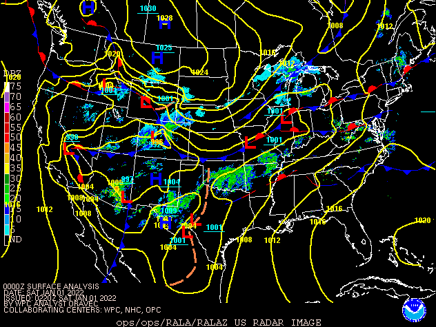 |
| Figure 1: Surface Analysis/Radar Loop from 7 PM December 31st through 7 AM January 2nd |
Environmental data around the time of heaviest rainfall.
 |
 |
 |
|
Figure 2: Precipitable Water at 5 AM January 1st |
Figure 3: 925-850 mb Moisture Transport at 5 AM January 1st | Figure 4: Most Unstable CAPE at 5 AM January 1st |
Environmental data around the time of the Estill County tornado.
 |
 |
 |
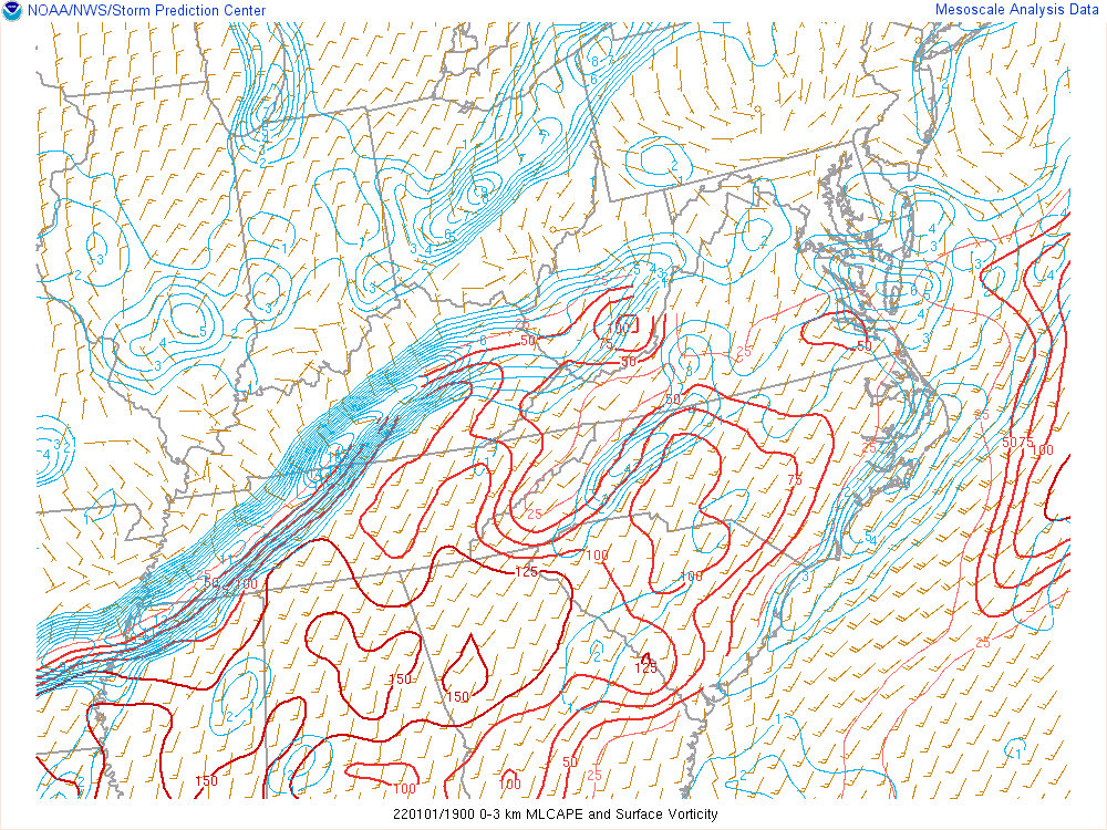 |
| Figure 5: Sea Level Pressure at 2 PM January 1st | Figure 6: Effective Shear at 2 PM January 1st | Figure 7: Effective Storm Relative Helicity at 2 PM January 1st | Figure 8: Surface Vorticity & 0-3 km MLCAPE at 2 PM January 1st |
 |
Media use of NWS Web News Stories is encouraged! Please acknowledge the NWS as the source of any news information accessed from this site. |
|