
Dangerous and extreme heat will remain across portions of the Central U.S. this week, persisting across the Mid to Lower Mississippi Valleys, Gulf Coast, Southern Plains and portions of Texas. A heat wave over the Southwest will intensify late this week. Severe thunderstorms and flash flooding will spread from the Great Lakes/Ohio Valley to the Mid-Atlantic and Northeast the next few days. Read More >
Overview
Video Courtesy of Ben Childers.
Video Courtesy of Salih Grahic.
|
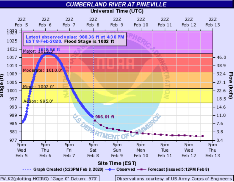
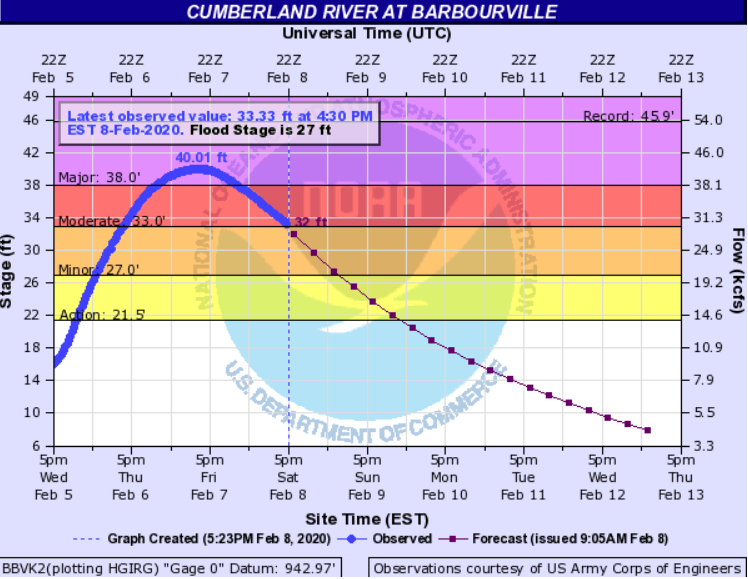
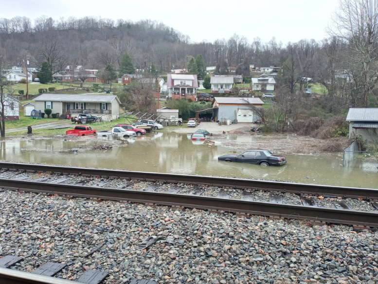
Beginning on February 3rd, numerous rounds of rainfall began to impact eastern Kentucky. This continued through February 7th, highlighted by heavy rainfall from the evening of February 5th through the first half of February 6th. Rain amounts of 4-6 inches fell across much of southeastern Kentucky over this period. This led to major flooding and numerous mudslides across portions of Whitley, Perry, Letcher, Leslie, Knox, Harlan, Clay, and Bell Counties. The Governor subsequently declared a State of Emergency for these 8 counties. Major flooding occurred along the Cumberland River at Pineville, Barbourville, and Williamsburg. Additionally, the communities of Loyall and Baxter experienced major flooding. Numerous roads became impassable across large portions of Whitley, Knox, Clay, Leslie, Letcher, Harlan, Perry, and Bell counties. In particular, Harlan County was hit extremely hard with the Kentucky Mesonet site on Black Mountain (4031 foot elevation) receiving over 6.5 inches of rain over this stretch. Flood gates were closed in Pineville and Harlan, further impacting local travel. A couple of mobile homes were flooded and swept down the Cumberland River in Harlan County, while swift water rescues took place in Bell and Harlan Counties. Elkhorn Dam in Jenkins had water rushing over it for a period of time on February 6. A man went missing in Whitley County and was later found deceased in his car on Kentucky Highway 779 after his attempt to drive into flood waters. A total of seven homes were reported to have been in or under water across Whitley County as the Cumberland River in Williamsburg crested to its third highest stage on record of 34.84 feet. The city of Pineville saw the river rise to its second highest crest in history at 1019.06 feet, leading to several families being stranded without homes. While impacts were certainly greatest along the Cumberland River, several portions of the Kentucky River also flooded. Several roads were impacted in Hazard and Whitesburg, while Booneville, Heidelberg, and Ravenna also exceeded flood stage. Along the Levisa Fork of the Big Sandy River, a rarity occurred as Pikeville hit flood stage and forced the city to shut its flood gates. |
 Aerial view of Harlan from near the Dayholt Community. Courtesy of Stacy Stewart via WYMT. |
Below is a look at all of the Cumberland, Kentucky, and Levisa Fork River forecast points. Pineville, Barbourville, and Williamsburg all reached major flood stage. Williamsburg reached 34.84 feet, which fell just short of their all time record crest of 35.03 feet. For Williamsburg, this was the third highest crest, following April of 1977 and March 1886. Pineville reached 1019.06 feet, which was the 2nd highest crest on record following April of 1977.
Cumberland River Hydrographs
 |
 |
| Cumberland | Loyall |
 |
 |
 |
| Pineville | Barbourville | Williamsburg |
Kentucky River Hydrographs
 |
 |
 |
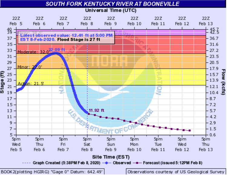 |
| Whitesburg | Hazard | Jackson | Booneville |
 |
 |
||
| Heidelberg | Ravenna | ||
Levisa Fork Hydrographs
 |
 |
 |
| Pikeville | Prestonsburg | Paintsville |

| Location | County | Source | Snowfall Amount |
| Cressy 1 NNE | Estill | COOP | 4.3" |
| Clover Bottom 1 W | Jackson | COOP | 4.0" |
| Oggs Station | Montgomery | NWS Employee | 3.8" |
| Mount Vernon 1 SSE | Rockcastle | Trained Spotter | 3.5" |
| Brodhead 2 SE | Rockcastle | Public | 3.0" |
| Stark 4 N | Elliott | COOP | 2.5" |
| Ezel 2 SSW | Morgan | COOP | 2.5" |
| Waltersville 1N | Powell | COOP | 2.5" |
| Farmers 1 SE | Rowan | COOP | 2.5" |
| Stanton 1 NNE | Powell | NWS Employee | 2.5" |
| Clay City 2 ENE | Powell | COOP | 2.4" |
| Murphyfork 1 SW | Morgan | NWS Employee | 2.3" |
| Mount Olive 2 NNE | Lee | COOP | 2.1" |
| Beverly | Bell | Trained Spotter | 2.0" |
| Lawson | Breathitt | NWS Employee | 1.2" |
| NWS Office | Breathitt | NWS | 1.0" |
| Thornton | Letcher | Public | 1.0" |
| Ermine 1 SW | Letcher | Public | 1.0" |
 |
 |
 |
 |
| Baxter Courtesy of Brandy Caudill |
Baxter Courtesy of Brandy Caudill |
Bell County Courtesy of the Big One 106.3 FM |
Bell County Courtesy of WYMT |
 |
 |
 |
 |
| Bledsoe Mudslide Courtesy of Harlan Enterprise |
Cumberland Falls Courtesy of Kentucky Mesonet |
Cumberland Falls Courtesy of Kentucky Mesonet |
Fresh Meadows in Harlan Courtesy of Chrystal Collett |
 |
 |
 |
 |
| Harlan Flood Gates Closed Courtesy of Roger Fannin |
Hiram in Harlan County Courtesy of Pete Cornett |
Kelly Street in Evarts Courtesy of Renee Doan |
Pineville behind Shell gas Station Courtesy of Christina Floyd |
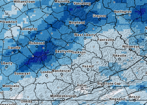
Radar Loop 1 pm Wednesday, February 5th Through 1 pm Thursday, February 6th
5 Day Rainfall Totals (February 4th - 8th)
| Location | County | Source | 5 Day Total |
| Pineville River Gage | Bell | USGS | 7.14" |
| Harlan 3 N | Harlan | COOP | 6.52" |
| Black Mountain | Harlan | KY Mesonet | 6.51" |
| Barbourville | Knox | KY Mesonet | 5.23" |
| Harlan 3 N | Harlan | COOP | 5.15" |
| Whitesburg 2 SE | Letcher | COOP | 4.90" |
| Whitesburg | Letcher | KY Mesonet | 4.30" |
| Whitley City | McCreary | KY Mesonet | 3.91" |
| Dorton | Pike | KY Mesonet | 3.67" |
| Somerset 7 NNE | Pulaski | KY Mesonet | 3.64" |
| McKee 5 S | Jackson | KY Mesonet | 3.24" |
| Hindman 5 N | Knott | KY Mesonet | 2.91" |
| Quicksand | Breathitt | KY Mesonet | 2.90" |
| Booneville 2 S | Owsley | KY Mesonet | 2.68" |
| Paintsville 4 W | Johnson | KY Mesonet | 2.11" |
| West Liberty 2 SW | Morgan | KY Mesonet | 1.26" |
| Owingsville 4 S | Bath | KY Mesonet | 1.17" |
.gif) |
| Surface Map Wednesday, February 5th to Thursday, February 6th |
 |
| Precipitable Water 4 pm Wednesday, February 5th to 6 am Thursday, February 6th |
.gif) |
| 850mb Moisture Transport 4 pm Wednesday, February 5th to 6 am Thursday, February 6th |
 |
Media use of NWS Web News Stories is encouraged! Please acknowledge the NWS as the source of any news information accessed from this site. |
|


