Thunderstorms and periods of heavy to excessive rainfall will continue over Florida through Thursday; and will begin to impact the central Plains today. Dry and gusty conditions will promote elevated to critical fire weather conditions in the Southeast. A Kona Low is expected to bring strong winds, widespread heavy rainfall, and flooding concerns to the island chain through the weekend. Read More >
Overview
|
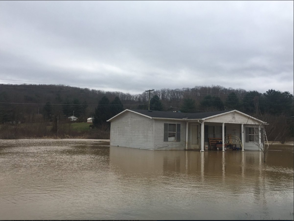
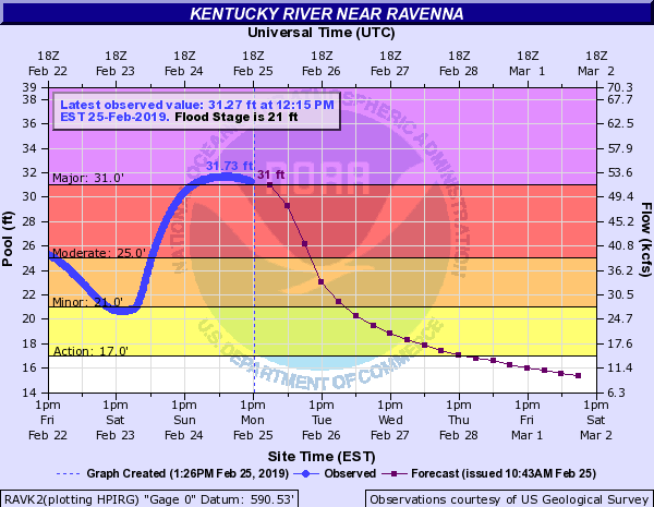
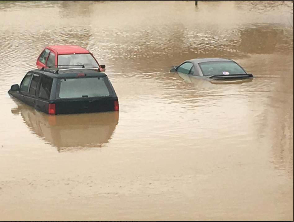
Periods of rain worked back into eastern Kentucky early on February 20 as a warm frontal boundary lifted north across the Commonwealth. A cold front brought additional rainfall through the afternoon and evening, before drier conditions worked into eastern Kentucky during the morning of February 21. Rain quickly spread back north that evening into the 22nd with southeastern Kentucky continuing to see prolonged light rain into the afternoon of the 23rd. A cold front brought additional rain to much of eastern Kentucky late on the 23rd. A spike in moisture ahead of this front resulted in additional moderate to heavy rain and high rainfall rates across portions of eastern Kentucky late on the 23rd. The convection ahead of the cold front that evening resulted in the majority of the flooding and flash flooding issues across eastern Kentucky. Showers and thunderstorms capable of heavy rainfall trained over parts of Wayne, Pulaski, Rockcastle, and other counties along the I-75 corridor, resulting in deadly flash flooding and river flooding along the Cumberland River. Later in the evening, the bulk of the rainfall shifted north to counties along the Mountain Parkway. Flash flooding and river flooding occurred in Powell, Wolfe, Breathitt, Magoffin, and Johnson Counties. Lighter rainfall continued into the night as flooding issues remained widespread into the 24th. Rainfall amounts from this event ranged from near 2 inches in portions of the Bluegrass region and northeast Kentucky, to greater than 4 inches across locations in southern and southeast Kentucky. This additional water on top of saturated ground continued to promote mud and rock slides across eastern Kentucky, complete with power outages from fallen debris and trees. Pikeville experienced a massive rockslide early on February 22, resulting in several cars and a building being damaged. Other impacts included countless roads being inundated with standing water, pavement and water pipes breaking, water threatening homes, roads and bridges being washed away, and rising lake levels. Of the 33 counties across eastern Kentucky, at least 27 were forced to declare State of Emergencies due to rainfall during and before this event. This included Knott County due to over $150,000 in county road damages. Beattyville, Clay City, Harlan, Hazard, Jenkins, Monticello, Paintsville, Pikeville, Salyersville, Stanton, West Liberty, and Whitesburg also declared State of Emergencies. Additionally, the Kentucky Governor declared a State of Emergency across the entire Commonwealth. The persistent rainfall of the winter season and the amount of rainfall from this event led to Lake Cumberland reporting their highest lake level of 756.52 feet on February 26th, breaking the old record of 751.69 feet dating back to May 1984. As a result, Wolf Creek Dam had to release at a record discharge level of 59,880 cubic feet per second. Cave Run Lake also rose to within 6 feet of their record pool elevation. Buckhorn Lake came within 10 feet of their all-time record, partially resulting in Kentucky Highway 257 near Confluence having flood waters cover the highway isolating 40 to 50 families for numerous days following the end of the flooding rains. |
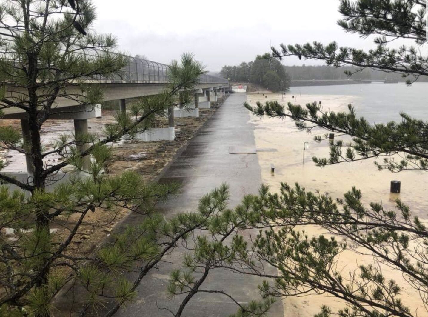
Laurel River Lake Spillway (Courtesy of Laurel County Emergency Manager) |
River Flooding
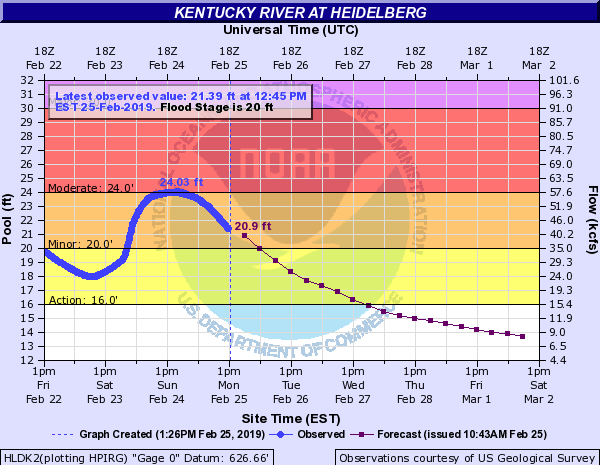
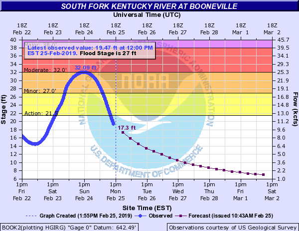
Kentucky River Flooding:
 |
 |
 |
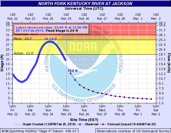 |
| Ravenna | Heidelberg | Booneville (South Fork) | Jackson (North Fork) |
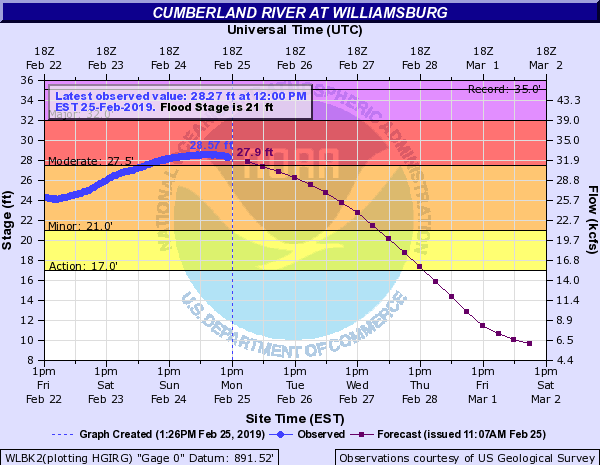
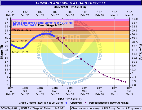
Cumberland River Flooding:
 |
 |
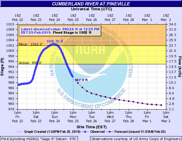 |
| Williamsburg | Barbourville | Pineville |
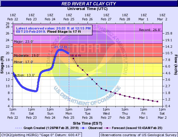
Red and Big Sandy River Flooding:
 |
 |
| Clay City (Red River) | Paintsville (Levisa Fork) |
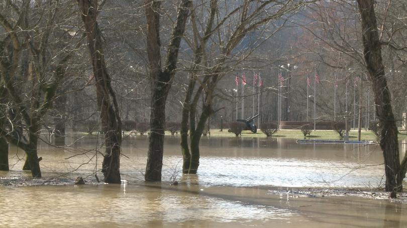
Photos
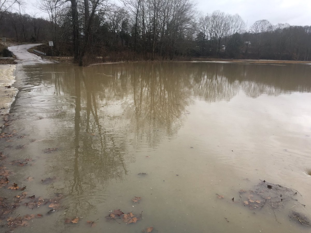
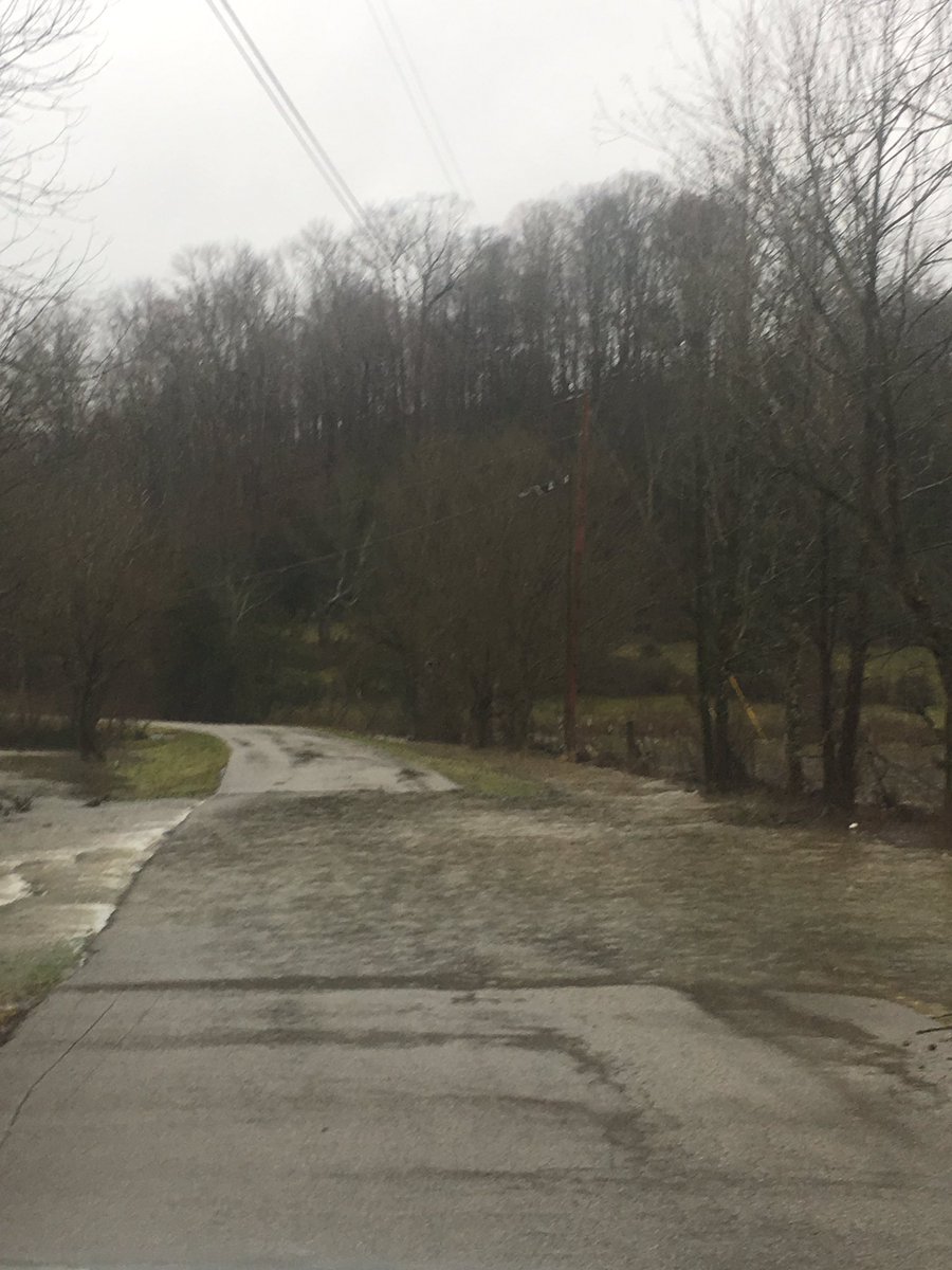
Flooding Pictures:
 |
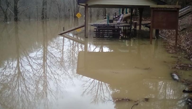 |
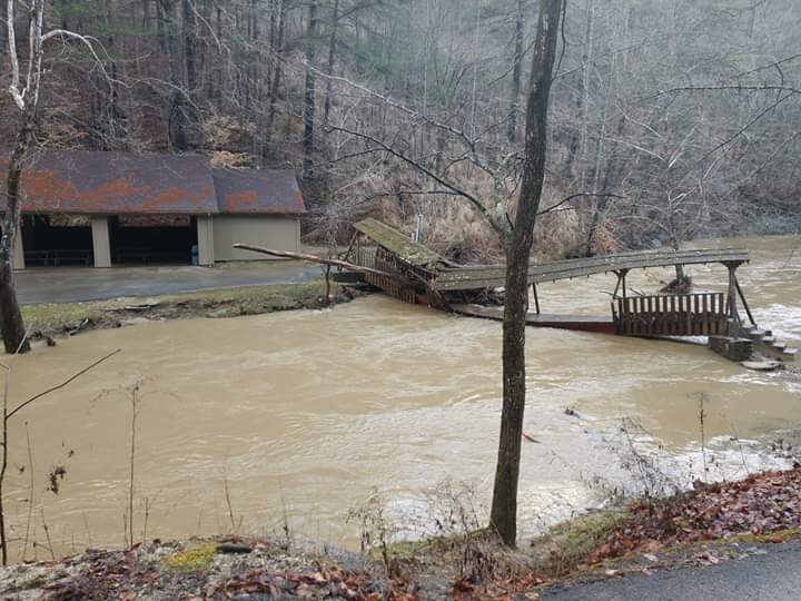 |
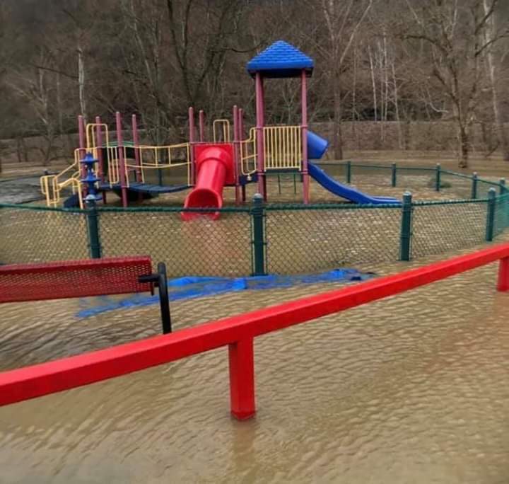 |
| Archer Park in Prestonsburg - Floyd County (Courtesy WYMT) |
Confluence, KY - Leslie County (Courtesy WYMT) |
Footbridge at Natural Bridge State Park - Powell County (Courtesy Johnny Ray Feltner) |
Douthitt Park, Jackson, KY - Breathitt County (Courtesy Johnny Ray Feltner) |
 |
 |
 |
 |
| Roundstone Creek near Mount Vernon - Rockcastle County (Courtesy Jordan Smith) |
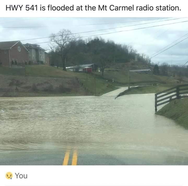
Highway 541 near Kentucky Mountain Bible College - Breathitt County (Courtesy Johnny Ray Feltner) |
Lake Linville Flooding Near Mount Vernon - Rockcastle County (Courtesy Jordan Smith) |
Flooding in Rockcastle County (Courtesy Jordan Smith) |
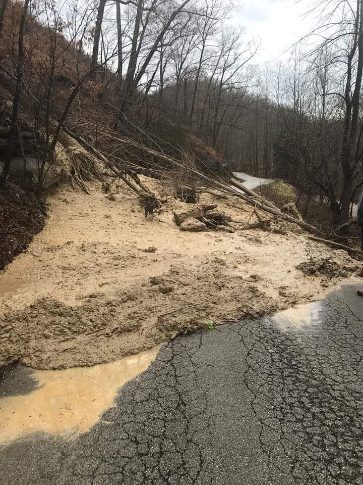
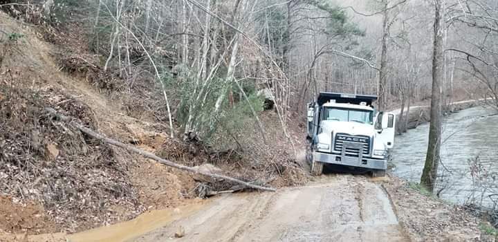
Rock/Mud Slides:
 |
 |
 |
 |
| Bowlings Creek - Breathitt County (Courtesy Johnny Ray Feltner) |
Jonancy - Pike County (Courtesy Johnny Ray Feltner) |
Pikeville - Pike County (Courtesy WYMT) |
Pikeville - Pike County (Courtesy WYMT) |
 |
 |
| Quicksand Creek Road - Breathitt County (Courtesy Johnny Ray Feltner) |
Highway 7 - Letcher/Knott County Line (Courtesy Troublesome Creek Times) |
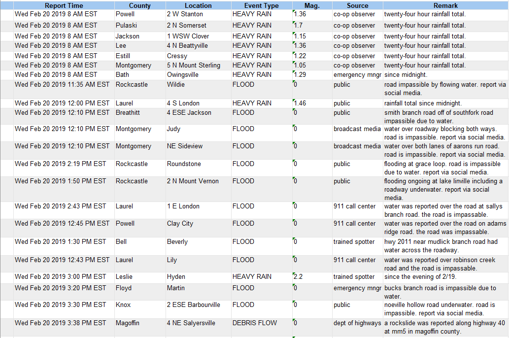
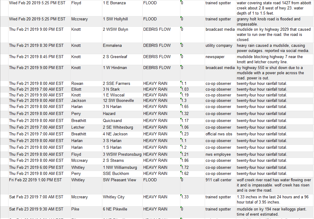
Rain Reports
5 Day Rainfall Totals Ending Sunday (February 24th) Morning

Location                     Amount     Provider
Beattyville 4n               5.21 in    COOP
Meldrum                      5.21 in    HADS
Billows                      5.16 in    HADS
Heidelberg                   5.11 in    USARMY-COE
Harlan 3n                    5.11 in    UCOOP
London Airport               5.07 in    NWS
Booneville                   5.02 in    HADS
Stearns River                4.89 in    USARMY-COE
Lawson                       4.81 in    COCORAHS
Gray Hawk                    4.75 in    HADS
Lost Creek                   4.74 in    COCORAHS
Cumberland River             4.71 in    GOES
Oneida                       4.70 in    COOP
4 SW Blue Heron              4.65 in    HADS
Tallega                      4.63 in    HADS
Paintsville River            4.59 in    USARMY-COE
Saxton                       4.56 in    HADS
Jackson                      4.47 in    HADS
Corbin Dam                   4.46 in    USARMY-COE
Somerset                     4.45 in    RAWS
Booneville 12sw              4.44 in    COOP
Jackson Airport (NWS)        4.42 in    NWS
Manchester                   4.42 in    USGS
Koomer Ridge                 4.34 in    RAWS
Barbourville                 4.32 in    HADS
Hazard                       4.25 in    HADS
Buckhorn Lake                4.24 in    COOP
1 S North Corbin             4.13 in    HADS
Hyden River                  4.10 in    USARMY-COE
Laurel Lake Dam              4.10 in    USARMY-COE
Farmers                      4.06 in    HADS
1 SW Pikeville               4.01 in    HADS
Barnetts Creek               4.01 in    HADS
Sand Hill                    3.97 in    HADS
Inez 2e                      3.97 in    COOP
Prestonsburg 3wsw            3.97 in    COOP
Jackson Apt                  3.94 in    RAWS
Williamsburg                 3.94 in    HADS
Paintsville 1e               3.82 in    COOP
Stanton 2w                   3.79 in    COOP
1 ENE Gates                  3.66 in    COCORAHS
Cressy                       3.64 in    UCOOP
Levisa Fork Telemark         3.60 in    COOP
Skyline                      3.50 in    COOP
Big Sandy                    3.49 in    RAWS
Cranks Creek Reservoir       3.46 in    GOES
Virgie                       3.44 in    USARMY-COE
2 SE Whitesburg              3.36 in    COOP
2 W Fishtrap Lake            3.30 in    HADS
Elkhorn City                 3.26 in    HADS
Diablock                     3.26 in    CWOP
Whitesburg                   3.18 in    HADS
Carr Fork Lake               3.17 in    COOP
Cave Run Lake                3.10 in    COOP
Triangle Mtn                 2.89 in    RAWS
Environment
Surface Maps:
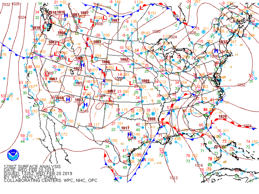 |
| February 20th to February 24th Surface Maps |
Preconditions Heading Into Flood Event:
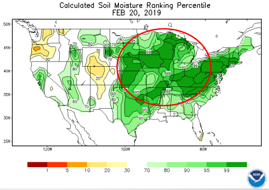 |
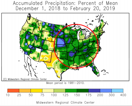 |
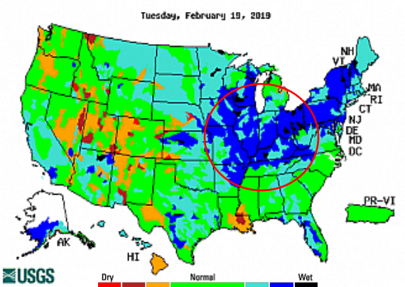 |
| Calculated Soil Moisture Ranking Percentile; February 20th, 2019 | Accumulated Precipitation: Percent of Mean; December 1st, 2018 - February 20th, 2019 | Streamflow; February 19th, 2019 |
Favorable Environment for Flash Flooding and Heavy Rain, February 23rd, 2019:
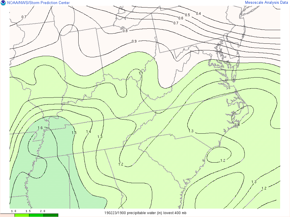 |
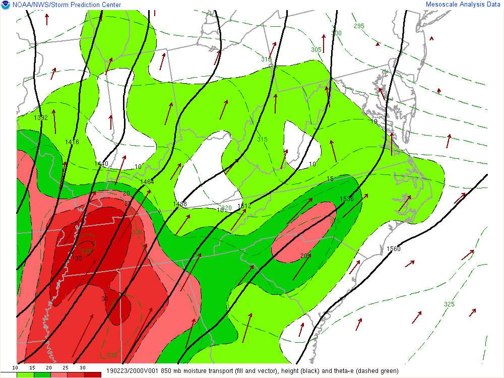 |
| 2 pm EST - 11 pm EST, Saturday, February 23rd Observed Precipitable Water (PW) | 2 pm EST - 11 pm EST, Saturday, February 23rd Observed 850mb Moisture Transport |
 |
Media use of NWS Web News Stories is encouraged! Please acknowledge the NWS as the source of any news information accessed from this site. |
|