
Unseasonably warm temperatures continue today across the southern U.S., with more than 100 record or near record maximum temperatures forecast through the rest of the week and over the weekend. Dry and gusty winds will produce elevated to critical fire weather in the central and southern Plains and elevated conditions over portions of the Desert Southwest on Friday. Read More >
Overview
An area of low pressure moving across the Tennessee Valley brought an area of persistent light to moderate rain into southeastern Kentucky, beginning this Sunday morning April 23rd and lasting into the overnight hours. This round of rain fell on top of what had fallen the previous several days, thus leading to numerous instances of flooding.
Rivers and streams began to rise through the day as widespread four day rainfall amounts of 4-5 inches fell near the Virginia and Tennessee state lines, with three day amounts of 3-4 inches common. Several roads were closed due to high water, while multiple points along the Cumberland River experienced minor flooding for the next couple of days. One man was rescued 30 yards downstream along the Cumberland River near Williamsburg, where moderate flooding occurred, as he was pulled into the high waters. Minor flooding was also reported on the Kentucky River at Ravenna and Hazard, while several points along the Kentucky and Big Sandy Rivers breached action stage.
 Cumberland Falls following the weekend's rains. Courtesy WYMT. |
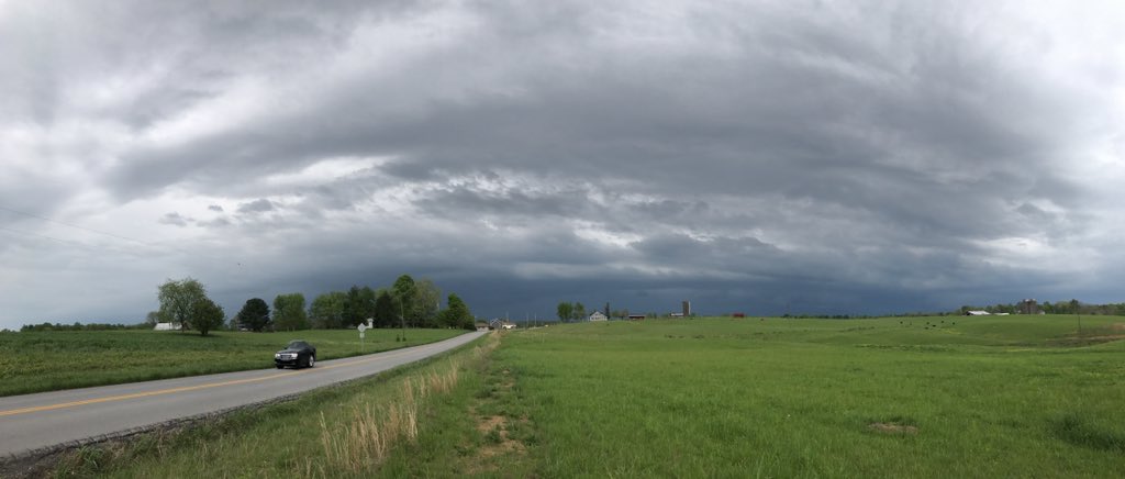 A shelf cloud approaching London. Courtesy Johnnie Nicholson. |
 |
 |
 |
| Water over Tackett Creek Road south of Williamsburg. Courtesy WKYT. | Flooding in Harlan County. Courtesy Jennifer. | Archer Park in Prestonsburg. Courtesy Allen Bolling. |
 |
 |
 |
| Mudslide on Highway 1344 near Calvin in Bell County. Courtesy local emergency management. | Flooding on Highway 15 from Smoot Creek near Dry Fork in Letcher County. Courtesy WYMT. | Highway 699 in Cutshin in Leslie County. Courtesy WYMT. |
River Flooding - Hydrographs
 |
 |
 |
| Moderate flooding on the Cumberland River at Williamsburg. | Minor Flooding on the Cumberland River at Barbourville. | Minor Flooding on the Cumberland River at Pineville. |
 |
 |
| Minor Flooding on the Kentucky River at Ravenna. | Minor Flooding on the Kentucky River at Hazard. |
Radar
 |
| Radar imagery from Sunday morning into the early evening. |
Rainfall Amounts
Public Information Statement
National Weather Service Jackson KY
125 PM EDT Mon Apr 24 2017

...A wet weekend across eastern Kentucky...

A slow moving storm system brought several rounds of rain to the area
over the weekend.  The rain was heaviest over the Upper Cumberland
region and headwaters of the Kentucky River and river flooding
produced by runoff from this rainfall was an ongoing concern.

The following report provides a summary of automated and human-read
rain gauge data available in each county in the NWS Jackson, KY
forecast and warning area for the 4 day period ending around
8 am EDT Monday April 24th.

Id      Station Name              Lat/Lon     Total
...Bath County Gauges...
PRSTKY Owingsville 4S Mesonet   38.09/-83.76   0.61

...Bell County Gauges...
1A6    Middlesboro AWOS         36.62/-83.74   4.69
YELK2  Yellow Creek RAWS        36.60/-83.70   4.98
MDLK2  Meldrum Stream Gauge     36.67/-83.69   4.57
PVLK2  Pineville River Gauge    36.76/-83.69   3.76

...Breathitt County Gauges...
KYBE01 Talbert 1.9ESE COCORAHS  37.41/-83.43   2.20
QKSDKY Jackson 3SE Mesonet      37.54/-83.34   1.62
JKL    Jackson ASOS             37.60/-83.32   1.32
JKNK2  Jackson River Gauge      37.55/-83.39   1.16

...Clay County Gauges...
ODAK2  Oneida Coop              37.27/-83.65   2.88
CHTK2  Peabody RAWS             37.14/-83.58   3.53

...Elliott County Gauges...
GIMK2  Gimlet 9N Coop           38.22/-83.13   0.47
SDHK2  Sandy Hook Coop          38.10/-83.12   0.56

...Estill County Gauges...
CSYK2  Cressy Coop              37.83/-84.04   0.77

...Fleming County Gauges...
FLEK2  Flemingsburg 2N Coop     38.45/-83.73   0.58
SRKK2  Sharkey Stream Gauge     38.25/-83.57   0.60

...Floyd County Gauges...
DWYK2  Dewey Lake Stream Gauge  37.74/-82.73   1.03
PSTK2  Prestonsburg River Gauge 37.67/-82.78   1.16

...Harlan County Gauges...
HARK2  Harlan 3S                36.81/-83.34   4.94
HROK2  Harlan 3N Coop           36.88/-83.31   4.01
BMTNKY Harlan 24E Mesonet       36.92/-82.91   4.90
CMBK2  Cumberland River Gauge   36.97/-82.99   4.41
LYLK2  Lloyal River Gauge       36.85/-83.35   3.54
MFLK2  Martin Fork Lk Gauge     36.75/-83.25   5.06
CCLK2  Cranks Creek Lk Gauge    36.73/-83.23   4.76

...Jackson County Gauges...
CAVK2  Clover Bottom Coop       37.49/-84.17   1.20
KYJC01 McKee 9.4NW COCORAHS     37.52/-84.11   1.33
OLINKY McKee 5S Mesonet         37.36/-83.97   1.89
GRHK2  Gray Hawk Gauge          37.40/-83.95   1.79

...Johnson County Gauges...
PNVK2  Paintsville 1E Coop      37.82/-82.78   0.95
BTCKKY Paintsville 4W Mesonet   37.83/-82.88   0.86
PTVK2  Paintsville River Gauge  37.82/-82.79   1.03
PNTK2  Paintsville Lake Gauge   37.84/-82.87   0.77

...Knott County Gauges...
CFLK2  Carr Creek Lake Coop     37.23/-83.0W   2.61
VESTKY Hindman 5N Mesonet       37.41/-82.99   2.27
CFLK2  Carr Creek Lk Dam Gauge  37.23/-83.03   3.38

...Knox County Gauges...
BBVK2  Barbourville Water Coop  36.86/-83.89   3.50
BMBLKY Barbourville 3E Mesonet  36.87/-83.83   3.39
BBVK2  Barbourville River Gauge 36.86/-83.89   2.92

...Laurel County Gauges...
LDNK2  London KSP Coop          37.13/-84.10   3.20
BUNK2  Bunch Coop               37.10/-84.21   2.64
LOZ    London Corbin Apt        37.08/-84.07   3.23
BLWK2  Billows River Gauge      37.17/-84.30   2.17
CBNK2  Corbin Dam Gauge         36.97/-84.12   3.84

...Lee County Gauges...
BCAK2  Beattyville 4N Coop      37.63/-83.72   1.01
TLLK2  Tallega River Gauge      37.55/-83.60   1.11

...Leslie County Gauges...
HYDK2  Hyden River Gauge        37.14/-83.37   3.18

...Letcher County Gauges...
WHBK2  Whitesburg 2SE Coop      37.10/-82.80   4.29
SKLK2  Skyline Coop             37.07/-82.97   4.05
KYLT03 Jeremiah 1.4N COCORAHS   37.19/-82.93   3.48
WTBGKY Whitesburg 2NW Mesonet   37.13/-82.84   4.05
WHTK2  Whitesburg River Gauge   37.12/-82.82   4.32

...Magoffin County Gauges...
SWWK2  Salyersville Water Coop  37.74/-83.07   1.05

...Martin County Gauges...
INEK2  Inez 2E Coop             37.87/-82.52   0.91
BSAK2  Big Sandy RAWS           37.75/-82.63   1.18

...McCreary County Gauges...
STRK2  Stearns Coop             36.67/-84.48   5.10
FLRKKY Whitley City 3N Mesonet  36.77/-84.48   5.36

...Menifee County Gauges...
WELK2  Wellington Coop          37.95/-83.48   0.87

...Montgomery County Gauges...
IOB    Mt Sterling Airport      38.06/-83.98   0.56

...Morgan County Gauges...
WLBTKY West Liberty 2SW Mesonet 37.90/-83.27   0.79

...Owsley County Gauges...
ICYK2  Island City Coop         37.36/-83.77   2.22
BNVLKY Booneville 2S Mesonet    37.45/-83.69   1.66

...Perry County Gauges...
BUCK2  Buckhorn Lake Coop       37.33/-83.47   2.66
HAZK2  Hazard Water Plant Coop  37.25/-83.18   2.63
KYPR04 Viper 0.5N               37.19/-83.15   3.32
BUCK2  Buckhorn Lake Dam Gauge  37.33/-83.47   2.53
HAZK2  Hazard River Gauge       37.25/-83.18   2.54

...Pike County Gauges...
DORTKY Pikeville 13S Mesonet    37.28/-82.52   2.91
PKYK2  Pikeville River Gauge    37.46/-82.53   2.58
FTLK2  Fishtrap Lake Gauge      37.43/-82.42   2.41
VRGK2  Virgie Gauge             37.33/-82.58   2.10
ELKK2  Elkhorn City River Gauge 37.30/-82.34   3.23

...Powell County Gauges...
CYCK2  Clay City 1WNW Coop      37.86/-83.93   0.81
STAK2  Stanton 2W Coop          37.86/-83.90   0.85
CYCK2  Clay City River Gauge    37.86/-83.93   0.73

...Pulaski County Gauges...
SSTK2  Somerset 2N Coop         37.12/-84.62   1.74
SSTK2  Somerset Stream Gauge    37.12/-84.62   1.75
SOMK2  Somerset Apt RAWS        37.06/-84.61   2.01

...Rockcastle County Gauges...
KYRC02 Brodhead 7.3SSW COCORAHS 37.30/-84.46   1.43

...Rowan County Gauges...
CRLK2  Cave Run Lake Coop       38.12/-83.53   0.58
KYRW03 Morehead 6.4NE COCORAHS  38.24/-83.34   0.70
MRHDKY Morehead 4NE Mesonet     38.22/-83.48   0.62
TRMK2  Triangle Mtn RAWS        38.17/-83.41   0.46
CRLK2  Cave Run Lake Dam Gauge  38.12/-83.53   0.31

...Wayne County Gauges...
KYWY01 Monticello 9.1W COCORAHS 36.82/-85.01   2.98
EKQ    Monticello AWOS          36.86/-84.86   2.33
MTCK2  Monticello Stream Gauge  36.87/-84.83   3.98

...Whitley County Gauges...
WWPK2  Williamsburg 1NW Coop    36.74/-84.18   4.27
KYWH05 Corbin 7.3SW COCORAHS    36.87/-84.21   4.71
WLBK2  Williamsburg River Gauge 36.74/-84.16   3.98
CORK2  Corbin Stream Gauge      36.95/-84.10   4.65
SXTK2  Saxton River Gauge       36.63/-84.11   4.07

...Wolfe County Gauges...
KOMK2  Koomer Ridge RAWS        37.78/-83.63   0.82

$$
3 Day Rainfall - Friday April 21 - Sunday April 23, 2017
 |
| 3 day rainfall amounts from Friday April 21 through Sunday April 23. |
 |
Media use of NWS Web News Stories is encouraged! Please acknowledge the NWS as the source of any news information accessed from this site. |
|

