
Dangerous and extreme heat will remain across portions of the central U.S. this week, persisting across the mid to lower Mississippi Valley, Gulf Coast, southern Plains and portions of Texas. A heat wave over the Southwest U.S. will peak this weekend. Heavy to excessive rainfall may produce flash flooding from the Delmarva Peninsula north into the Hudson Valley today and tonight. Read More >
Thunderstorms developed and trained over a narrow corridor producing flash flooding in southwest Breathitt and northern Perry County during the early morning hours of May 1st. Later in the day, numerous strong to severe storms raked across eastern Kentucky during the afternoon and evening hours. The storms formed in a warm moist air mass ahead of an approaching cold front. The storms produced hail as large as 1.75 inches in diameter, damaging winds, and flooding across the area.
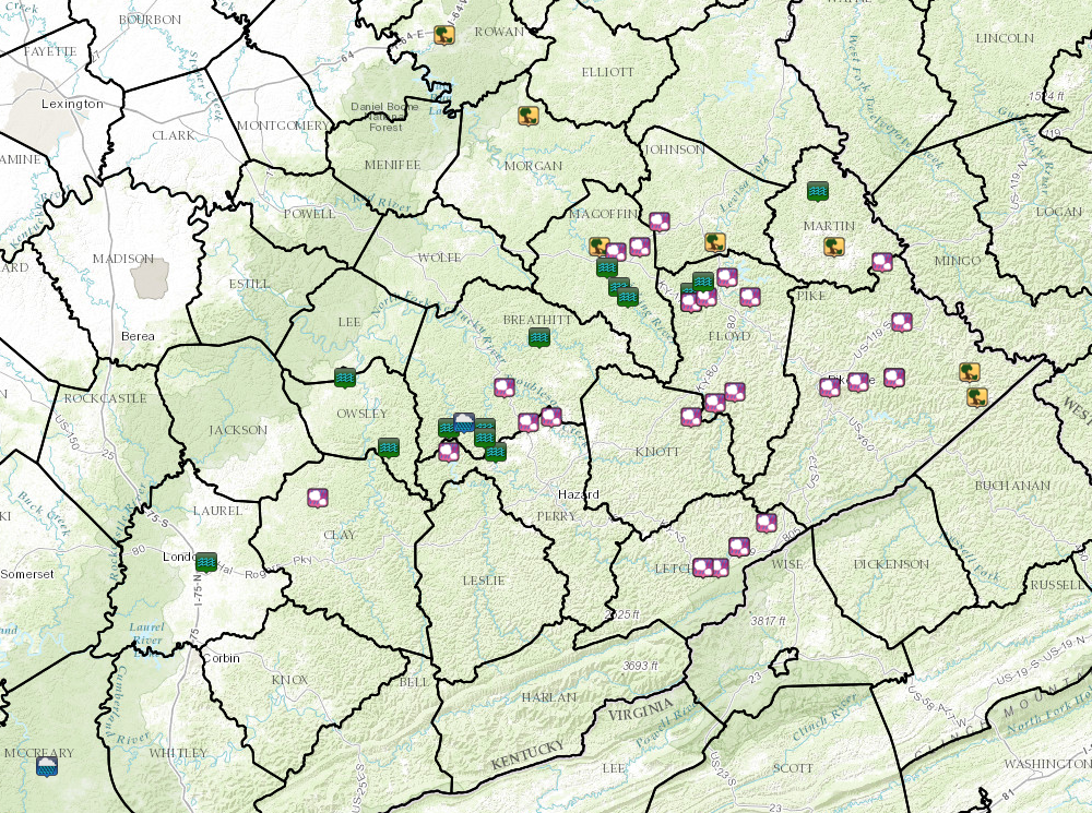 Local Storm Reports from May 1-2, 2016. |
Local Storm Reports
| Timestamps are UTC | |||||||
| Report Time | County | Location | Event Type | Mag. | Source | Remark | |
| Sun May 01 2016 09:03:00 GMT-0400 (Eastern Daylight Time) | Perry | Chavies | FLOOD | 0 | broadcast media | water over portions of keneva rd along eversole creek and approaching some homes. | |
| Sun May 01 2016 09:45:00 GMT-0400 (Eastern Daylight Time) | Breathitt | Wolf Coal | FLASH FLOOD | 0 | nws employee | water several feet deep over hwy 1933. | |
| Sun May 01 2016 09:45:00 GMT-0400 (Eastern Daylight Time) | Breathitt | Altro | FLASH FLOOD | 0 | nws employee | water inside church. | |
| Sun May 01 2016 10:02:00 GMT-0400 (Eastern Daylight Time) | Laurel | London | FLOOD | 0 | 911 call center | several roads with standing water on them around london, but depth of water over roads is unknown. | |
| Sun May 01 2016 11:00:00 GMT-0400 (Eastern Daylight Time) | Breathitt | Crockettsville | FLASH FLOOD | 0 | nws employee | water over bowling creek road. a family is trapped due to a bridge being washed out. | |
| Sun May 01 2016 11:20:00 GMT-0400 (Eastern Daylight Time) | Martin | Inez | FLOOD | 0 | co-op observer | water over road on turkey creek road at inez water plant. completely blocking one lane of road and almost completely blocking other lane. | |
| Sun May 01 2016 11:20:00 GMT-0400 (Eastern Daylight Time) | Floyd | 5 W Prestonsburg | FLOOD | 0 | trained spotter | a home on middle creek road is almost completely surrounded by water. | |
| Sun May 01 2016 11:20:00 GMT-0400 (Eastern Daylight Time) | Floyd | 5 W Prestonsburg | FLASH FLOOD | 0 | trained spotter | a home on middle creek road is almost completely surrounded by water. | |
| Sun May 01 2016 12:04:00 GMT-0400 (Eastern Daylight Time) | Magoffin | Sublett | FLOOD | 0 | trained spotter | hwy 1635 has 3 to 4 inches of water over road and road is impassible. | |
| Sun May 01 2016 13:00:00 GMT-0400 (Eastern Daylight Time) | Breathitt | 2 ESE Talbert | HEAVY RAIN | 3.77 | nws employee | 24 hour rainfall total. | |
| Sun May 01 2016 13:15:00 GMT-0400 (Eastern Daylight Time) | Floyd | Dotson | FLOOD | 0 | nws employee | water is over granny fitz bridge rd. | |
| Sun May 01 2016 19:45:00 GMT-0400 (Eastern Daylight Time) | Magoffin | 2 WNW Salyersville | TSTM WND DMG | 0 | 911 call center | large tree on powerlines on elk creek rd. | |
| Sun May 01 2016 20:15:00 GMT-0400 (Eastern Daylight Time) | Magoffin | 1 E Salyersville | HAIL | 1 | broadcast media | ||
| Sun May 01 2016 20:30:00 GMT-0400 (Eastern Daylight Time) | Johnson | 3 S Paintsville | TSTM WND DMG | 0 | 911 call center | tree down on ky 1750 at east point. | |
| Sun May 01 2016 20:42:00 GMT-0400 (Eastern Daylight Time) | Floyd | 2 N Prestonsburg | HAIL | 0.5 | trained spotter | ||
| Sun May 01 2016 21:15:00 GMT-0400 (Eastern Daylight Time) | Martin | 1 SW Mcclure | TSTM WND DMG | 0 | dept of highways | tree down near wolfe creek area. | |
| Sun May 01 2016 22:00:00 GMT-0400 (Eastern Daylight Time) | Rowan | 2 WSW Morehead | TSTM WND DMG | 0 | 911 call center | large tree across power line at the junction of jewell lane and skaggs road. | |
| Sun May 01 2016 22:15:00 GMT-0400 (Eastern Daylight Time) | Morgan | N Wrigley | TSTM WND DMG | 0 | 911 call center | tree down on hwy 711 on dehart rd. | |
| Sun May 01 2016 23:06:00 GMT-0400 (Eastern Daylight Time) | Magoffin | 4 ENE Salyersville | HAIL | 1 | public | ||
| Sun May 01 2016 23:06:00 GMT-0400 (Eastern Daylight Time) | Johnson | Oil Springs | HAIL | 0.25 | trained spotter | ||
| Sun May 01 2016 23:20:00 GMT-0400 (Eastern Daylight Time) | Pike | Kimper | HAIL | 1.75 | public | picture from wymt facebook page and chris johnson wymt | |
| Sun May 01 2016 23:30:00 GMT-0400 (Eastern Daylight Time) | Pike | 2 NW Paw Paw | TSTM WND DMG | 0 | dept of highways | several trees down along jct 194. | |
| Sun May 01 2016 23:30:00 GMT-0400 (Eastern Daylight Time) | Pike | Phelps | TSTM WND DMG | 0 | 911 call center | tree down near phelps. | |
| Mon May 02 2016 00:48:00 GMT-0400 (Eastern Daylight Time) | Breathitt | 1 SW Rousseau | FLOOD | 0 | public | water is now over ky30w and is about the depth of a car tire. also reported water over hwy542 at an unknown depth. | |
| Mon May 02 2016 01:06:00 GMT-0400 (Eastern Daylight Time) | Magoffin | Lakesville | FLOOD | 0 | amateur radio | road flooded at route 7 near meadow going toward royalton, and also along ky1090 toward lakesville | |
| Mon May 02 2016 17:49:00 GMT-0400 (Eastern Daylight Time) | Floyd | Dotson | HAIL | 0.75 | trained spotter | ||
| Mon May 02 2016 17:49:00 GMT-0400 (Eastern Daylight Time) | Floyd | 3 WSW Prestonsburg | HAIL | 0.88 | nws employee | ||
| Mon May 02 2016 18:05:00 GMT-0400 (Eastern Daylight Time) | Floyd | 3 ESE Prestonsburg | HAIL | 1 | public | via local business | |
| Mon May 02 2016 18:08:00 GMT-0400 (Eastern Daylight Time) | Clay | Burning Springs | HAIL | 1.75 | 911 call center | ||
| Mon May 02 2016 18:20:00 GMT-0400 (Eastern Daylight Time) | Perry | Buckhorn | HAIL | 1.75 | public | ||
| Mon May 02 2016 18:30:00 GMT-0400 (Eastern Daylight Time) | Owsley | Sebastian | HAIL | 1 | 911 call center | the right hand fork of buffalo. | |
| Mon May 02 2016 18:36:00 GMT-0400 (Eastern Daylight Time) | Letcher | Whitesburg | HAIL | 1.25 | public | quarter size and larger hail reported on social media. | |
| Mon May 02 2016 18:40:00 GMT-0400 (Eastern Daylight Time) | Pike | Hatfield Station | HAIL | 1 | public | via social media | |
| Mon May 02 2016 18:45:00 GMT-0400 (Eastern Daylight Time) | Letcher | Thornton | HAIL | 1.75 | trained spotter | ||
| Mon May 02 2016 18:50:00 GMT-0400 (Eastern Daylight Time) | Letcher | Mcroberts | HAIL | 1.25 | trained spotter | hail off and on for 15 minutes. began as dime size and got as large as half dollars. | |
| Mon May 02 2016 18:50:00 GMT-0400 (Eastern Daylight Time) | Breathitt | Ned | HAIL | 1.75 | trained spotter | ||
| Mon May 02 2016 18:55:00 GMT-0400 (Eastern Daylight Time) | Perry | Rowdy | HAIL | 1 | public | via social media | |
| Mon May 02 2016 18:58:00 GMT-0400 (Eastern Daylight Time) | Breathitt | Lost Creek | HAIL | 1 | public | information via social media site. | |
| Mon May 02 2016 18:58:00 GMT-0400 (Eastern Daylight Time) | Letcher | Ermine | HAIL | 1.25 | public | information obtained via social media site. | |
| Mon May 02 2016 18:58:00 GMT-0400 (Eastern Daylight Time) | Letcher | Whitesburg | HAIL | 1 | public | information obtained from social media site. | |
| Mon May 02 2016 19:05:00 GMT-0400 (Eastern Daylight Time) | Owsley | Pebworth | FLASH FLOOD | 0 | broadcast media | local media posted pictures of water flowing over over highway 11 and around buildings in the pebworth community. | |
| Mon May 02 2016 19:13:00 GMT-0400 (Eastern Daylight Time) | Floyd | Wayland | HAIL | 2 | public | ||
| Mon May 02 2016 19:14:00 GMT-0400 (Eastern Daylight Time) | Knott | 1 E Mousie | HAIL | 1.25 | trained spotter | ||
| Mon May 02 2016 19:20:00 GMT-0400 (Eastern Daylight Time) | Floyd | Minnie | HAIL | 1.25 | public | ||
| Mon May 02 2016 19:32:00 GMT-0400 (Eastern Daylight Time) | Pike | Pikeville | HAIL | 1 | trained spotter | ||
| Mon May 02 2016 19:38:00 GMT-0400 (Eastern Daylight Time) | Pike | Raccoon | HAIL | 1 | public | social media report via facebook | |
| Mon May 02 2016 19:40:00 GMT-0400 (Eastern Daylight Time) | Owsley | Sebastian | FLASH FLOOD | 0 | 911 call center | the following roads are under water and have been closed spivey road, jug road, marcum ridge road, hwy 11 north at pebworth, and the right hand fork of buffalo. | |
| Mon May 02 2016 19:45:00 GMT-0400 (Eastern Daylight Time) | Letcher | Thornton | HAIL | 1.75 | trained spotter | ||
| Mon May 02 2016 19:50:00 GMT-0400 (Eastern Daylight Time) | Pike | Kimper | HAIL | 2 | public | report via charleston nws office | |
| Mon May 02 2016 19:53:00 GMT-0400 (Eastern Daylight Time) | Magoffin | 1 S Royalton | FLASH FLOOD | 0 | trained spotter | hwy 1635...aka oakley road...is being inundated by oakly creek. road is impassable. | |
| Mon May 02 2016 20:00:00 GMT-0400 (Eastern Daylight Time) | Floyd | 2 E Bonanza | FLASH FLOOD | 0 | trained spotter | highway 1427 impassable due to high water | |
| Mon May 02 2016 20:01:00 GMT-0400 (Eastern Daylight Time) | Pike | Canada | HAIL | 1 | public | social media report via twitter | |
| Mon May 02 2016 21:25:00 GMT-0400 (Eastern Daylight Time) | Mccreary | Whitley City | HEAVY RAIN | 1.48 | trained spotter | from around 2 pm today until 525 pm. | |
 |
Media use of NWS Web News Stories is encouraged! Please acknowledge the NWS as the source of any news information accessed from this site. |
|

