Severe thunderstorms are forecast through this weekend along a slow moving cold front and secondary storm system that will impact areas from the southern Plains to the Great Lakes. Large hail and isolated damaging wind gusts are the main threats with these storms along with a risk for heavy to excessive rainfall which could bring flooding. Read More >
Widespread wind damage and deadly flash flooding occurred across eastern Kentucky as three distinct waves of heavy rain and thunderstorms affected the area from Monday afternoon July 13th through Tuesday evening July 14th.
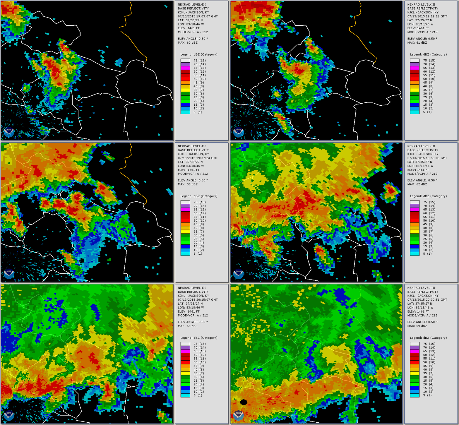
The first rounds of thunderstorms caused severe flash flooding in three areas, the Flatgap/Redbush communities of Johnson County, Hays Branch of Triplett Creek in Rowan County and Buchanan Road in Fleming County. The hardest hit area was the Flatgap/Redbush community of Johnson County where devastating flash flooding occurred late Monday afternoon along Big Mudlick Creek and Ramey Branch. Four fatalities occurred and over 50 swift water rescues were performed in this area. Entire double wide houses were seen floating down Big Mudlick Creek and getting forced under a bridge. More than 150 homes were destroyed with as many as 500 homes being affected to some extent. While no rain gauges were located in this hard hit area, radar estimates indicate that around 3" of rain fell in an hour with brief rainfall rates of 6" to 7" per hour falling. Additional flash flooding occurred in Rowan County along US 60E northeast of Morehead where a CoCoRaHS observer measured 2.02" of rain in 30 minutes which caused extensive flooding of Hays Branch of Triplett Creek.
 |
 |
With the ground already saturated, the next two rounds of storms overnight Monday night and then during the afternoon and evening hours on Tuesday caused additional flash flooding and wind damage across a widespread area. Storms Tuesday afternoon produced a 6.5 mile long swath of concentrated wind damage north of Flemingsburg, KY which demolished a mobile home and injured four people as winds reached 100 mph. An EF1 tornado touched down briefly inside this larger path of damaging straight-line winds.
Additional severe wind damage occurred near Morehead in Rowan County and scattered about in other communities across eastern Kentucky. All in all, there were around 200 different severe weather (flash flood, wind damage, hail greater than 1" in diamter, and/or tornado) reports called into the National Weather Service office in Jackson, KY for the 36 hour period ending midnight Tuesday night. At one point, over 50,000 east Kentucky households were without power due to the storms with many remaining without power until Friday.
 |
 |
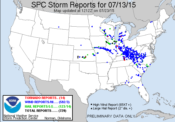
| SPC Storm Reports 8 am EDT July 13th through 8 am EDT July 14th |
SPC Storm Reports 8 am EDT July 14th through 8 am EDT July 15th |
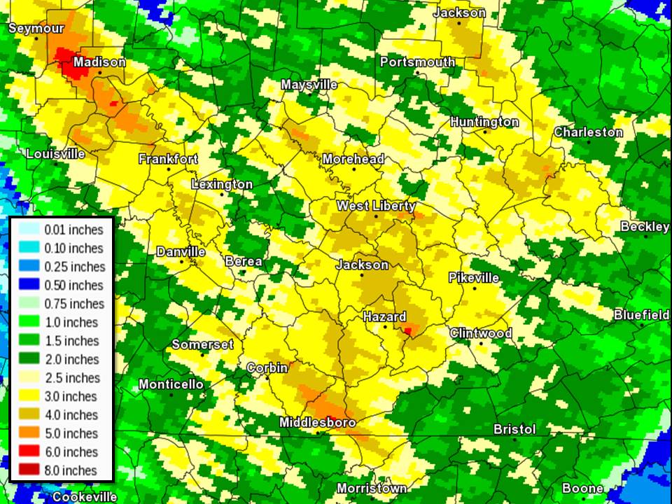
The three rounds of thunderstorms produced impressive two day rainfall totals across the region.
 |
...48 HOUR RAINFALL AMOUNTS ENDING AROUND 8 AM JULY 15TH...

* ONLY REPORTS OF 2.50 INCHES OR GREATER ARE INCLUDED IN THIS SUMMARY.

LOCATION                     AMOUNT     PROVIDER

...BELL COUNTY...
ARJAY                        5.64 IN    IFLOWS
COLDIRON                     3.94 IN    COOP
4 W MIDDLESBORO              3.31 IN    COOP

...BREATHITT COUNTY...
ROBINSON FOREST              5.75 IN    IFLOWS
TOWN HILL                    5.19 IN    IFLOWS
3 SE JACKSON                 3.85 IN    MESONET
NWS JACKSON                  3.75 IN    ASOS
JACKSON                      3.42 IN    USARMY-COE

...CLAY COUNTY...
ONEIDA                       3.81 IN    COOP
MANCHESTER                   3.54 IN    USGS

...ELLIOTT COUNTY...
DOCTOR TOWER                 3.17 IN    IFLOWS

...ESTILL COUNTY...
FURNACE                      3.99 IN    IFLOWS

...FLEMING COUNTY...
BALD HILL                    4.77 IN    IFLOWS
FLEMINGSBURG                 2.56 IN    COOP
BEECHBURG                    2.52 IN    IFLOWS

...FLOYD COUNTY...
3 WSW PRESTONSBURG           3.77 IN    COOP
DAVID                        3.48 IN    IFLOWS
RIGHT BEAVER                 3.26 IN    IFLOWS
DEWEY LAKE                   3.22 IN    USARMY-COE

...HARLAN COUNTY...
CUMBERLAND                   2.98 IN    USARMY-COE
E. JONES FARM                2.82 IN    IFLOWS
1 S HARLAN                   2.70 IN    COOP
BAXTER                       2.50 IN    COOP

...JACKSON COUNTY...
5 S MCKEE                    3.10 IN    MESONET
GRAY HAWK                    3.33 IN    IFLOWS
CLOVER BOTTOM                2.89 IN    COOP
MCKEE                        2.77 IN    IFLOWS

...JOHNSON COUNTY...
4 W PAINTSVILLE              3.12 IN    MESONET

...KNOTT COUNTY...
HINDMAN                      4.84 IN    IFLOWS
PIPPA PASSES                 4.45 IN    IFLOWS
CARR CREEK LAKE              3.87 IN    COOP

...KNOX COUNTY...
3 E BARBOURVILLE             4.29 IN    MESONET
BARBOURVILLE WATER PLANT     4.01 IN    COOP
ARTEMUS                      3.94 IN    IFLOWS
JOHNSON HOLLOW               3.70 IN    IFLOWS
HELTON BRANCH                2.93 IN    IFLOWS

...LAUREL COUNTY...
EAST BERNSTADT               4.13 IN    IFLOWS
MONEY ROAD                   4.02 IN    IFLOWS
BILLOWS                      3.84 IN    USARMY-COE
LONDON-CORBIN APT            3.46 IN    ASOS
BUNCH                        3.19 IN    COOP

...LEE COUNTY...
BEATTYVILLE                  4.53 IN    IFLOWS
4 N BEATTYVILLE              3.61 IN    COOP
TALLEGA                      2.94 IN    USARMY-COE

...LESLIE COUNTY...
LUCINDA                      5.45 IN    IFLOWS
WILDER BRANCH                4.11 IN    IFLOWS

...LETCHER COUNTY...
2 SE WHITESBURG              3.43 IN    COOP
SKYLINE                      3.40 IN    COOP
2 NW WHITESBURG              3.38 IN    MESONET

...MARTIN COUNTY...
BIG SANDY AIRPORT            3.85 IN    RAWS
2 E INEZ                     3.56 IN    COOP

...MCCREARY COUNTY...
STEARNS                      3.85 IN    IFLOWS
OSBOURNE CREEK               2.74 IN    IFLOWS
HAYES CREEK                  2.59 IN    IFLOWS

...MENIFEE COUNTY...
STONE QUARY                  3.31 IN    IFLOWS

...MORGAN COUNTY...
2 SW WEST LIBERTY            3.52 IN    MESONET

...OWSLEY COUNTY...
INDIAN CREEK                 5.18 IN    IFLOWS
STURGEON                     4.13 IN    IFLOWS
ISLAND CITY                  3.80 IN    COOP
2 S BOONEVILLE               3.65 IN    MESONET

...PERRY COUNTY...
ROCKHOUSE                    5.84 IN    IFLOWS
HAZARD                       4.46 IN    IFLOWS
HAZARD WATER PLANT           3.37 IN    COOP
BUCKHORN LAKE                3.59 IN    COOP

...PIKE COUNTY...
FLATWOODS                    4.86 IN    IFLOWS
13 S PIKEVILLE               2.75 IN    MESONET
JOHNS PEAK                   2.60 IN    IFLOWS

...PULASKI COUNTY...
PUNKIN FIRE DEPT             4.07 IN    IFLOWS

...ROCKCASTLE COUNTY...
LIVINGSTON                   3.15 IN    IFLOWS
CLIMAX FIRE DEPT             3.03 IN    IFLOWS

...ROWAN COUNTY...
CAVE RUN LAKE                3.65 IN    COOP
6.4 NE MOREHEAD              3.53 IN    COCORAHS
 -2.02 IN FELL IN 20 MINUTES MONDAY AFTERNOON
MOREHEAD FD #2               3.03 IN    IFLOWS
CLEARFIELD ELEMENTARY        3.00 IN    IFLOWS
4 NE MOREHEAD                2.99 IN    MESONET
TRIANGLE MOUNTAIN            2.52 IN    RAWS

...WAYNE COUNTY...
BELL                         2.72 IN    IFLOWS

...WOLFE COUNTY...
CAMPTON ELEMENTARY           3.39 IN    IFLOWS
STILLWATER                   3.35 IN    IFLOWS
RED RIVER SCHOOL             2.84 IN    IFLOWS

OBSERVATIONS ARE COLLECTED FROM A VARIETY OF SOURCES WITH VARYING
EQUIPMENT AND EXPOSURE. NOT ALL DATA LISTED ARE CONSIDERED OFFICIAL.