Parts of east Kentucky were hit by multiple rounds of showers and thunderstorms from August 18th through the 22nd. The repeating nature of the thunderstorm complexes caused rainfall totals to add up producing flash flooding.
Initially, the storms targeted an area from southern Breathitt, northern Perry into Knott County. Training showers and thunderstorms produced flash flooding in these areas during the morning hours of August 18th and then again two days later during the evening hours of August 20th.
|
August 18th and 20th Flash Flood Reports:
BREATHITT COUNTY Begin: 08/18/14 07:30 EDT End: 08/18/14 09:30 EDT
Flash flooding of Freeman Fork caused Freeman Fork Road to be impassable.
PERRY COUNTY Begin: 08/18/14 07:30 EDT End: 08/18/14 11:00 EDT
Over three inches of rain fell across northern Perry County. This amount of rain produced flash flooding which surrounded trailers in the Chavies Community, flooded a church near the intersection of Highway 15 and 28, and closed Highway 476 between Hardburly and Darfork.
KNOTT COUNTY Begin: 08/18/14 07:45 EDT End: 08/18/14 11:00 EDT
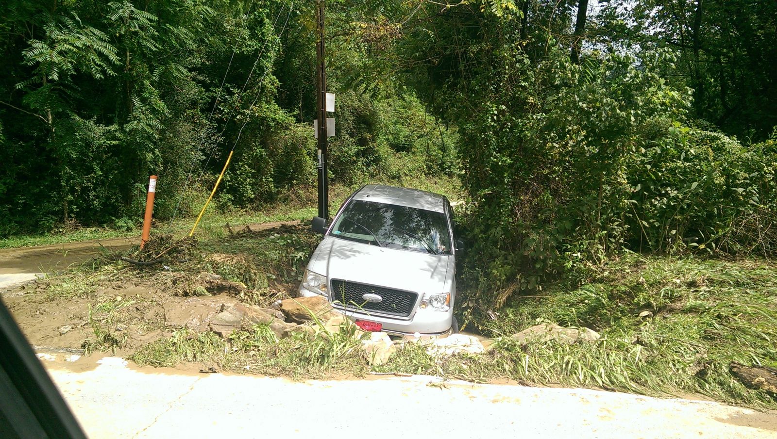
Over three inches of rainfall from slow moving thunderstorms produced flash flooding across the county. Troublesome Creek was reported out of its banks from Hindman to Carrie, six inches of flowing water was reported over Highway 80, flooding at the junction of Highway 550 and 160 made the roads impassable, flood waters surrounded a house in Garner, the Hazard Community & Technical School campus was flooded in Hindman, and water was reported over the bumper of an SUV between Leburn and Hindman.
PERRY COUNTY Begin: 08/20/14 19:20 EDT End: 08/21/14 00:00 EDT
Heavy rainfall from slow moving thunderstorms on saturated ground produced several areas of flash flooding across Perry County, including along Big Willard Road where several people were trapped in the Big Willard School. Grapevine Creek also flooded the Davidson Church along Highway 28 and flash flooding was reported along Bulan Hiner Road and along Old Highway 80 West near Combs. Several mudslides were also reported in Grapevine and Chavies.
KNOTT COUNTY Begin: 08/20/14 19:45 EDT End: 08/20/14 23:00 EDT
Troublesome creek was reported to have come out of its banks in the Carrie area shortly after a public report of 1.78 inches of rain fell in 35 minutes. A trailer on Lick Branch Road was flooded. A foot of flowing water was reported over Highway 1102. Also, the Ball Creek Volunteer Fire Dept assisted several families that were trapped by flood waters in their homes near Highway 550 in Hindman between 730 pm EST and 800 pm EST.
|
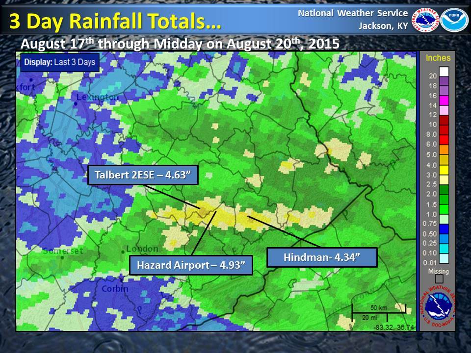
A second, more severe round of flash flooding occurred during the evening hours of August 22nd when training thunderstorms produced a band of three to four, and in some cases more, inches of rain over parts of Johnson, Floyd and Pike Counties. In most instances, the bulk of the rainfall indicated on the map below fell in 1 to 2 hours!

|
August 22nd Flash Flood Reports:
JOHNSON COUNTY Begin: 08/22/14 20:00 EDT End: 08/23/14 02:00 EDT
Widespread flash flooding occurred across much of Johnson County during the evening of August 22nd as over three inches of rain fell in one to two hours. Basements, garages and homes were flooded in numerous areas with multiple reports of road damage to private and public property. Roads were completely blocked and in some cases were completely washed away. There were also numerous reports of downed trees and electric lines due to mudslides. Sixteen homes were classified as having major damage along with two businesses.
FLOYD COUNTY Begin: 08/22/14 20:21 EDT End: 08/23/14 03:00 EDT
severe flash flooding occurred across parts of Floyd County as three to four inches of rain fell in one to two hours. Flash flood reports first came in from Lancer where eight inches to a foot of water was flowing across a roadway. Flood waters was reported to have entered homes and vehicles along Spradlin Branch and Mays Branch near Prestonsburg and Main Street and North Lake Drive were closed in downtown Prestonsburg. Highway 1427 was washed out by flood waters and the Creekside Subdivision near the confluence of Potts Branch and Abbott Creek was evacuated due to rising water. Flood water washed partially washed out the road at the junction of Highway 979 and 1426 near Harold. Flood waters were reported to be covering all four lanes of US 23 near Auxier as late as midnight.
PIKE COUNTY Begin: 08/22/14 20:22 EDT End: 08/23/14 02:00 EDT
A foot of water was reported flowing across Highway 3227 from Joes Creek into Johns Creek, with flooding beginning between 715 pm EST and 730 pm EST. Highway 90 at Kinnikinnick Lane was also flooded with people trapped inside of a residence. Stone Coal Creek flooded Stone Coal Road near the Walmart with water up to the guardrail. Hurricane Creek also flooded in multiple locations with water reported in the Old Regular Church near the community of Owsley.
Additional flash flood reports were received from Montgomery, Perry, Wolfe, Estill and Martin Counties on August 22nd.
|
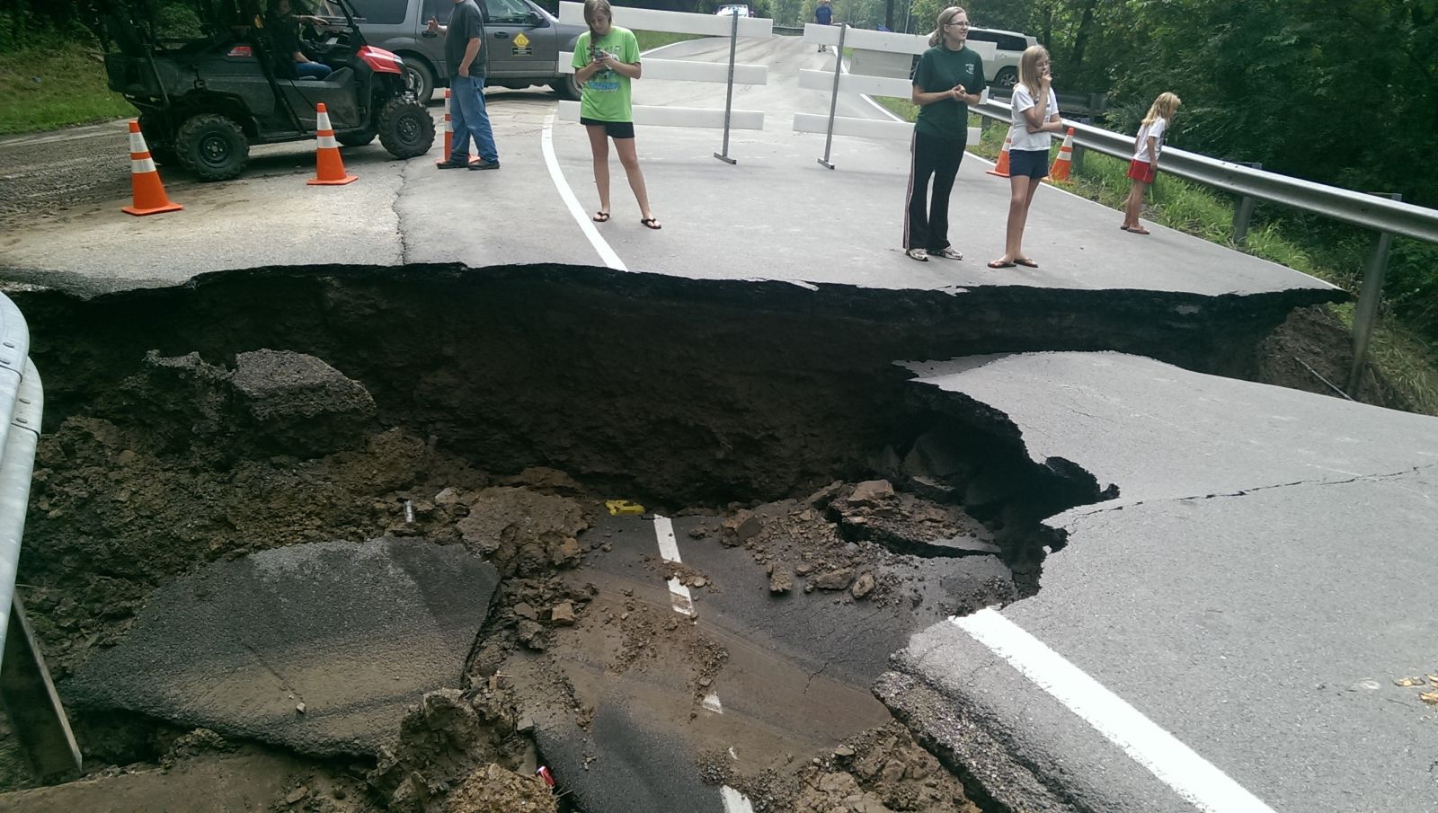
The picture below shows some of the damage as a section of highway 1428 near Prestonsburg was washed out. This was located near Short Branch. This is a good example as to why you should not drive across flooded roadways. You never know what lies below the flowing water. Thanks to Eric Thomas for the picture.
Included below is another picture sent to us from Eric Thomas taken on Kentucky 1428, 3 miles west of the intersection with US 23 looking from Abbott Creek Road up Potts branch.