Overview
A strong storm system and associated cold front approached eastern Kentucky on Easter Sunday, with rainfall beginning during the afternoon. As the low pressure system intensified and moved into the Ohio Valley during the evening of the 12th, wind speeds began to drastically increase across eastern Kentucky. The Kentucky Mesonet station in Dorton, (positioned at 2774 feet elevation) recorded a 79 mph wind gust!
Several other gusts of 40+ mph occurred, leading to numerous instances of damage across eastern Kentucky. This includes downed trees, power lines, and structural damage, causing several roadways to be blocked for a period of time into the morning of the 13th. As many as 70,000 to 75,000 power outages were reported across eastern Kentucky. As a result of these winds, Kentucky Power reported 318 poles had to be replaced while a total of 33 miles of electric wire were downed. Given the magnitude of this event, folks at the National Weather Service office in Jackson decided to take a more in depth look at this event and see what may have led to this damaging wind event.
After hours of discussion and research, we concluded this event was caused by gravity waves moving through the region. Several locations demonstrated significant surface pressure drops during the time of the strongest winds. This coincided with several features above the surface that are common with gravity waves. While events of this magnitude are rare, they have happened in the past and you can find some of these cases by accessing the "Additional Resources" tab below.
For additional information on this event please visit the original event summary page located HERE.
We would like to extend a special "Thank You" to the Kentucky Mesonet out of Western Kentucky University for providing much of the data.
What Is a Gravity Wave?
|
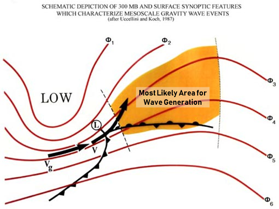
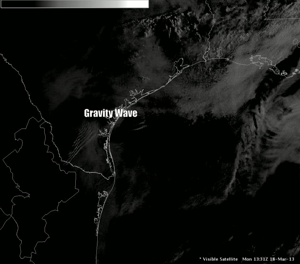
Gravity waves are a relatively common meteorological phenomenon that typically develop and dissipate in the mid to upper levels of the atmosphere without causing any readily apparent effects on our daily weather. In many ways, they can be thought of as ripples moving through the atmosphere which cause a rapid fall and rise in pressure along with a corresponding strong downward and upward motion. Gravity waves often appear in satellite images as shockwave or ripple patterns in the clouds. The figure on the right shows a gravity wave, captured by satellite imagery, causing a rippled cloud pattern off the Texas Coast. Gravity waves can be initiated by many different phenomena including deep convection, shear instability, momentum surges, geostrophic adjustment, unbalanced frontogenesis, and topography. However, a very special combination of atmospheric factors is required to maintain the waves and duct them to the Earth’s surface. The critical ingredient for the wave’s survival is a deep low-level inversion or stable layer, such as is found north of a surface warm front. This inversion layer must be very stable but also deep enough to contain at least a quarter of the vertical wavelength of the gravity wave. Furthermore, there must also be a conditionally unstable layer above the inversion layer to prevent the wave energy from propagating upwards and dissipating. When these conditions are met, the inversion layer provides a good medium for the continued horizontal propagation of the trapped gravity wave. Trapped gravity waves typically move at roughly the speed of the mean flow in which they are embedded. In the April 12-13 wind event, the mean wind was likely in excess of 60 mph based on the low-level RAP forecast wind speeds. Gravity wave wind events are very difficult to forecast and are often ongoing before forecasters are aware of their presence. One of the key tell-tale signs of a gravity wave is a sudden drop in surface pressure ahead of the approaching wave trough followed by the rapid onset of strong winds, peaking with the passage of the trough. Behind the trough, surface pressures rise rapidly and the winds diminish. A sharp back edge or break developing in a precipitation shield, indicative of sinking motions, can be another tell-tale sign of a gravity wave. |
Example of a gravity wave just off the coast of Texas caught by visible satellite |
April 12th-13th Event Details
In this particular case, the gravity wave generation seems to have been largely synoptic, although eastern Kentucky's terrain likely played some role in the wave's initiation and the channeling of the resulting winds. The nearby deep convection could have also played a role.
|
Here are some things to look for in a pattern that may support gravity waves:
|
 |
|
300mb chart at 00z April 13th has a negatively tilted and highly diffluent trough with a jet approaching downstream axis of inflection. This matches the pattern for gravity waves. |
06z April 13th Surface Map had a surface frontal boundary to the south or southeast of the area. |
|
An anomalous SSW low-level jet of 60+ knots at 850 mb was advecting into eastern Kentucky. |
The anomalous southwest jet was also noted at the 700 mb level. |
|
RAP Model Forecast 850mb Wind Speed and Direction. You can clearly see the increase in wind speeds aloft coinciding with the same time as the gravity waves push through the area. |
|
 |
|
|
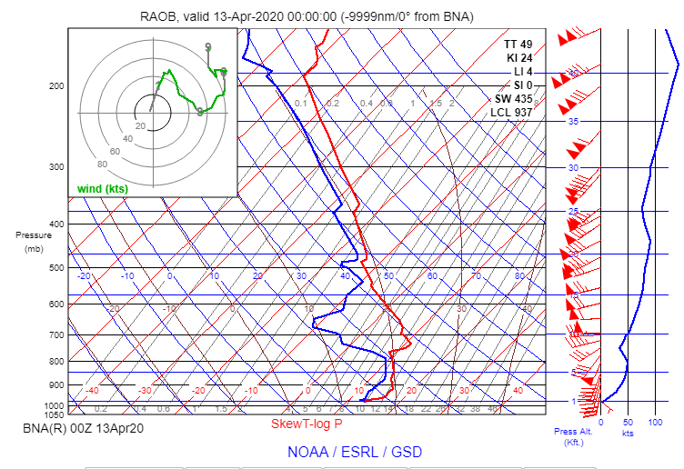
8 pm, April 12th Nashville (KBNA) Upper Air Sounding. Of note, you can clearly see the strong 40-50 knot low-level jet between ~ 900-775 mb over-topped by a sharp inversion and conditionally unstable layer, the key to maintaining a gravity wave near the surface. |
|
|
8 pm April 12th - 2 am April 13th Jackson (JKL) Radar Loop. You can notice the drying that occurs between 8 pm and 10 pm associated with the winds being forced downwards to the ground with the gravity waves. |
|
|
McCreary County Mesonet |
|
|
Pike County Mesonet (Dorton) |
|
|
London-Corbin Airport |
|
|
Knott County Mesonet |
|
|
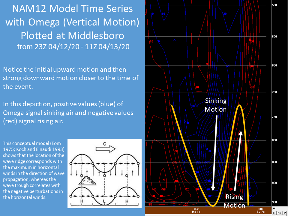
Graph of Jackson, KY surface pressure and wind gusts. The pressure dropped 5.4 mb in about 30 minutes! The Highest wind gust occurred as the pressure hit its minimum. |
|
Damage and Impacts
|
Here are some of the more notable areas of damage:
|
 |
|
 |
| Tree down on Baker Hill in Perry County. Courtesy of Johnny Ray Feltner. | Tree snapped on County Road near Kenny Lane in London. Courtesy of Team W700. | Bobby Davis Park Road in Hazard. Courtesy of Johnny Ray Feltner. |
 |
 |
 |
| Barn destroyed in Stinnett. Courtesy of WYMT. | Route 112 between McDowell and Wheelwright in Floyd County. Courtesy of local Sheriff's Office. | Damage to high school scoreboard in Pikeville. Courtesy WYMT. |
 |
 |
| Near Alice Lloyd College. Courtesy of Eddie Scarberry. | Near Alice Lloyd College. Courtesy of Eddie Scarberry. |
Wind Speeds
...HIGHEST WIND REPORTS APRIL 12TH...

Location                                       Speed     Time/Date       Lat/Lon
3 E Dorton (Pike County Mesonet)               79 MPH    1010 PM 04/12   37.28N/82.52W
1 WNW Yellow Mountain (Knott County Mesonet)   55 MPH    1045 PM 04/12   37.41N/82.99W
3 WNW Pleasant (Big Sandy Airport)             53 MPH    1209 AM 04/13   37.75N/82.63W
London-Corbin Airport                          49 MPH    0953 PM 04/12   37.08N/84.07W
1 WNW Big Black Mountain                       46 MPH    0805 PM 04/12   36.92N/82.91W
Shelbiana (Knox County Mesonet)                46 MPH    0930 PM 04/12   36.87N/83.83W
Pike County Airport                            45 MPH    1115 PM 04/12   37.57N/82.57W
Owingsville 4 S (Bath County Mesonet)          45 MPH    0115 AM 04/13   38.09N/83.76W
National Weather Service Office                44 MPH    0215 AM 04/13   37.59N/83.31W
Peabody RAWS                                   43 MPH    1101 PM 04/12   37.14N/83.58W
2 N Marshes Siding (McCreary County Mesonet)   42 MPH    0950 PM 04/12   36.77N/84.48W
Crown (Letcher County Mesonet)                 41 MPH    0915 PM 04/12   37.14N/82.85W
Williamsburg Airport                           40 MPH    0937 PM 04/12   36.84N/84.21W
Jackson Airport RAWS                           40 MPH    1115 PM 04/12   37.59N/83.32W
Additional Resources
October 25th, 2008 Gravity Wave Event Across Eastern North Carolina
February 3-4, 2006 Gravity Wave Event Across Charleston Harbor
April 9th, 2015 Gravity Wave Event Across South Texas
February 22nd, 1998 Gravity Wave Event Across Alabama
Researchers and Gravity Waves (Article from September 24th, 2019)
 |
Media use of NWS Web News Stories is encouraged! Please acknowledge the NWS as the source of any news information accessed from this site. |
|


.PNG)
.PNG)
.PNG)
.PNG)
.PNG)
