
Multiple corridors of severe thunderstorms are expected across the Upper Midwest on Monday into Monday night, with a regional severe weather outbreak possible. The most dangerous period is likely during the late afternoon and evening when strong tornado potential should be maximized. Scattered large to very large hail and damaging winds are likely as well. Read More >
Overview
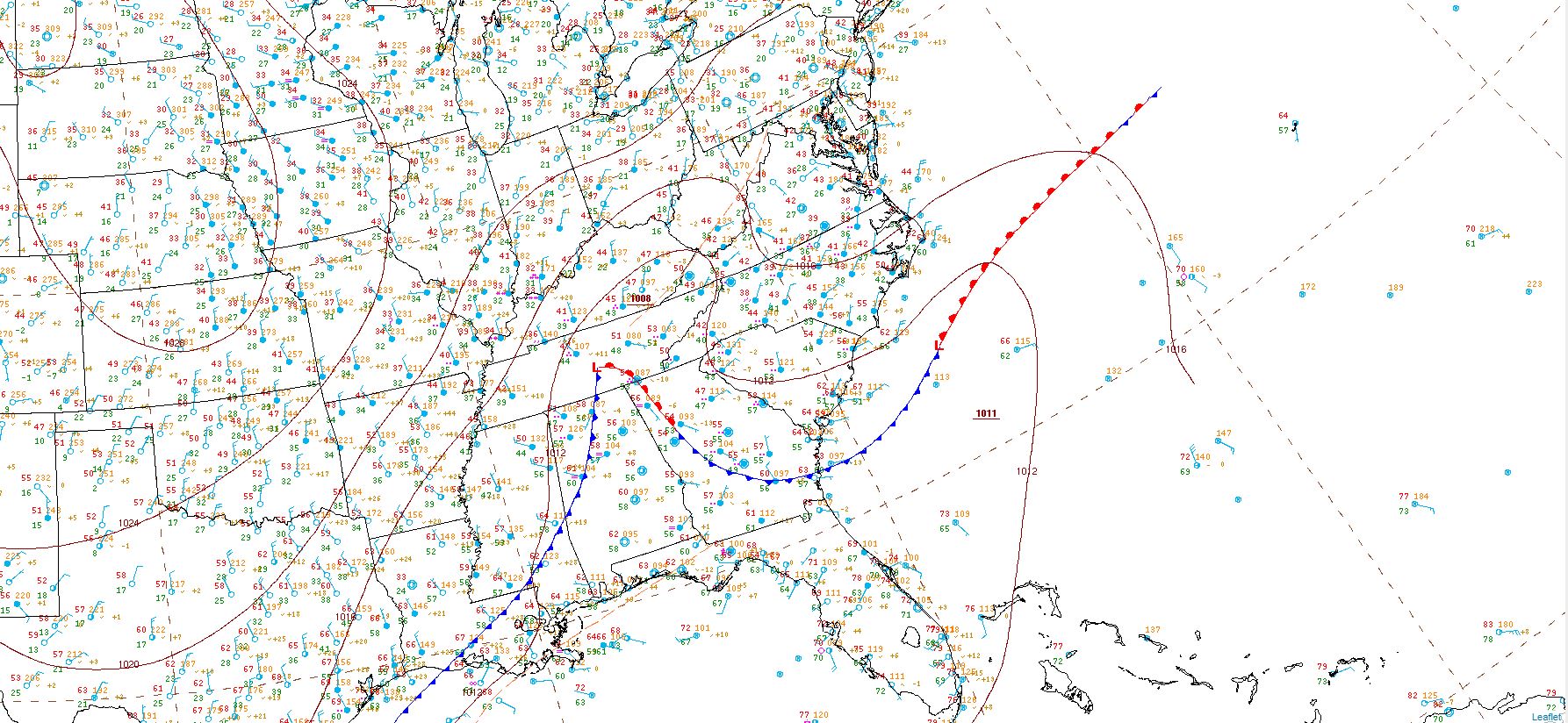
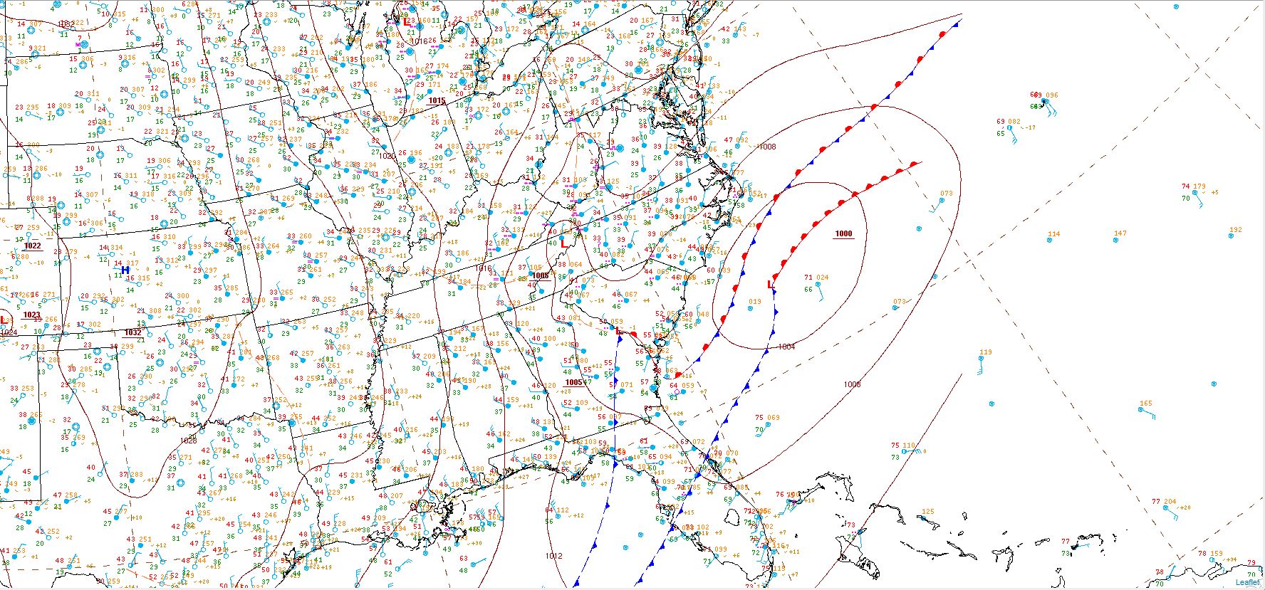
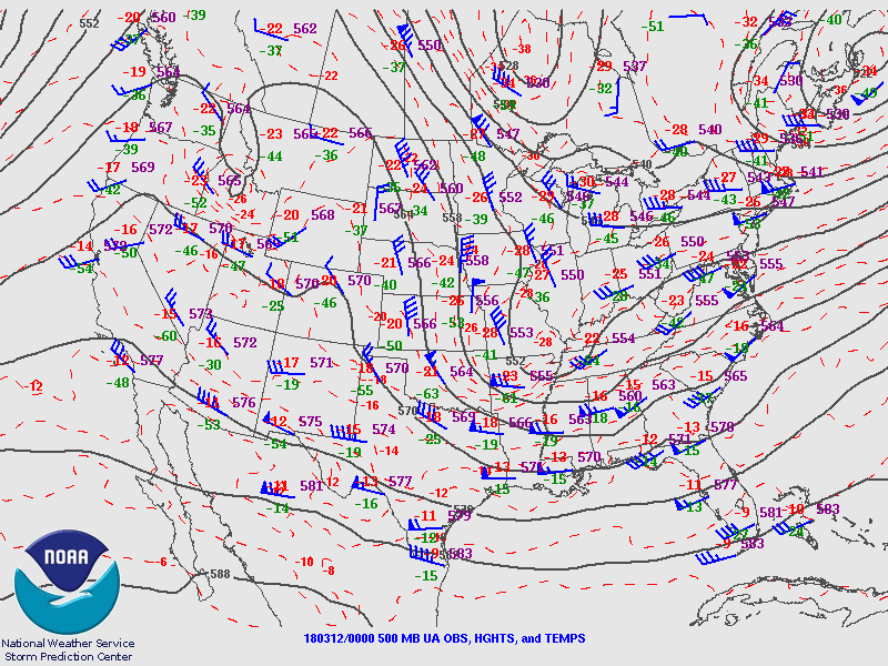
An upper level low moved into the TN and OH Valley region and then into the Appalachians from Sunday evening, March 11th into Monday, March 12th. At the same time, a surface low pressure system tracked into the TN Valley and southern Appalachians before redeveloping over the Southeastern U.S. during the night and then off the coast of the Carolinas on Monday. Temperatures on Sunday the 11th were mild, reaching the upper 40s to mid 50s. However, the upper level low brought colder air into the region and was strong enough to allow rapid cooling of the atmosphere to near or just below the freezing mark in most locations in East KY between 11 PM EDT on March 11 and 3 AM EDT on March 12. The development of heavier snow bands occurred at the same time over central KY, and with the cooling moving into eastern KY overnight, affected portions of east central KY first. These bands then moved east and affected areas generally north of KY Highway 80 to near the Mountain Parkway corridor. Within the bands, snowfall rates of up to 2 inches per hour occurred, leading to an area of heavier amounts (see storm reports below).
By 10 AM EDT on Monday, widespread accumulating snow had occurred over most of eastern Kentucky with the final band of snow working across the area. The snow finally exited into Virginia and West Virginia around 1 PM EDT. By that time, the heavy, wet snowfall totals ranged from as little as a half of an inch in some locations near the TN border to about 8 inches in areas near the Daniel Boone National Forest. A few localized higher amounts nearing 10 inches were observed on ridgetops from the Daniel Boone National Forest west.
At the height of the storm, at least 12,000 customers in East KY were without power. Slick and slushy conditions led to a 40 vehicle pileup on Mountain Parkway in eastern Powell County, forcing the closure of the roadway between 1:30 AM and 2:30 AM EDT Sunday night. In addition to the falling snow, trees and limbs succumbed to the weight of the heavy wet snow and fell onto roadways. Although with temperatures near freezing, plowing and salting improved road conditions during the day on Monday. This process was slowed a bit as highway departments, first responders, and utility companies cleared snow, large limbs, and utility lines from roadways.
 |
 |
 |
| Downed trees near Mount Vernon (photo courtesy of Jordan Smith) | Mount Vernon (photo courtesy of Jordan Smith) | Tree and power pole damage from heavy wet snow in Powell County (photo courtesy of Tim Brunota) |
 |
 |
 |
| Snow in trees in the distance in Morgan County (photo courtesy of Stacie Stacy) | Wintry scene from Stacy Fork Community in Morgan County (photo courtesy of Stacie Stacy)
|
Webcam view of Pikeville showing elevation dependent nature of the snowfall (photo courtesy of WOWK TV) |
Snowfall
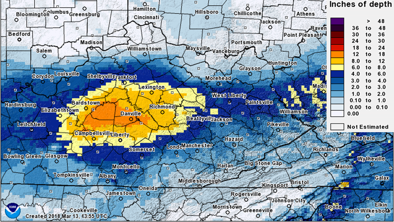
Computer analyzed snowfall for 24 hour period ending at 8 PM EDT on March 12, 2018. Amounts may not represent the exact snowfall in some locations. See below for more specific amounts:
...Snowfall Reports from the Wet Snow Event By County and Location...

Location                     Amount    Time/Date       Lat/Lon

...Kentucky...

...Bath County...
1 W Owingsville              3.2 in    0537 AM 03/12   38.14N/83.78W
Owingsville                  2.0 in    0800 AM 03/12   38.14N/83.76W

...Breathitt County...
2 NW Haginsville             5.0 in    1050 AM 03/12   37.59N/83.32W
2 SE Keck                    4.5 in    0450 AM 03/12   37.59N/83.34W
1 SE Fivemile                3.0 in    0630 AM 03/12   37.58N/83.39W
Lawson                       2.3 in    0809 AM 03/12   37.60N/83.46W

...Clay County...
Oneida                       1.0 in    0820 AM 03/12   37.27N/83.65W

...Elliott County...
3 N Stark                    2.0 in    0800 AM 03/12   38.22N/83.14W

...Estill County...
Cressy                       8.2 in    0700 AM 03/12   37.82N/84.04W
Irvine                       7.0 in    0745 AM 03/12   37.70N/83.97W
Irvine                       5.0 in    0312 AM 03/12   37.70N/83.97W

...Floyd County...
Bonanza                      2.8 in    1130 AM 03/12   37.69N/82.86W
Prestonsburg                 2.0 in    0726 AM 03/12   37.67N/82.77W
2 ENE Dotson                 1.8 in    0700 AM 03/12   37.66N/82.82W
1 E Blue River               1.5 in    0845 AM 03/12   37.62N/82.83W

...Jackson County...
1 WSW Clover Bottom          8.0 in    0745 AM 03/12   37.49N/84.17W
Sandgap                      5.0 in    0400 AM 03/12   37.48N/84.09W
1 N Loam                     4.0 in    0840 AM 03/12   37.42N/84.13W
1 ESE Maulden                2.7 in    0700 AM 03/12   37.35N/83.83W

...Johnson County...
Thealka                      3.0 in    0700 AM 03/12   37.82N/82.79W
1 WSW Wittensville           2.5 in    0530 AM 03/12   37.86N/82.81W

...Knott County...
2 SW Bolyn                   2.5 in    1130 AM 03/12   37.43N/82.93W
1 S Hindman                  1.8 in    1100 AM 03/12   37.32N/82.98W

...Lee County...
Yellow Rock                  7.0 in    0812 AM 03/12   37.57N/83.81W
2 NNE Mount Olive            6.2 in    0600 AM 03/12   37.64N/83.71W
1 NE Belle Point             5.8 in    1000 AM 03/12   37.57N/83.74W
1 NNW Belle Point            4.7 in    0700 AM 03/12   37.57N/83.75W
Beattyville                  4.0 in    0318 AM 03/12   37.58N/83.71W

...Letcher County...
1 ENE Payne Gap              2.0 in    1130 AM 03/12   37.16N/82.64W
1 SSW Ermine                 1.0 in    0700 AM 03/12   37.10N/82.80W

...Martin County...
2 SW Davella                 3.0 in    1130 AM 03/12   37.78N/82.60W
2 E Inez                     2.0 in    0700 AM 03/12   37.87N/82.50W

...McCreary County...
1 S Stearns                  0.2 in    0700 AM 03/12   36.68N/84.48W

...Menifee County...
Frenchburg                   7.0 in    0900 AM 03/12   37.95N/83.62W
Frenchburg                   4.0 in    0254 AM 03/12   37.95N/83.62W

...Montgomery County...
Oggs Station                 4.0 in    0528 AM 03/12   38.02N/83.83W
Mount Sterling               3.0 in    0800 AM 03/12   38.06N/83.95W

...Morgan County...
Ezel                         6.5 in    0700 AM 03/12   37.89N/83.44W
West Liberty                 4.0 in    0537 AM 03/12   37.91N/83.27W

...Perry County...
Hazard                       1.2 in    0744 AM 03/12   37.25N/83.20W
Rowdy                        1.0 in    0743 AM 03/12   37.42N/83.21W
Viper                        0.5 in    0855 AM 03/12   37.18N/83.15W

...Powell County...
2 SW Bowen                   8.5 in    0601 AM 03/12   37.82N/83.79W
2 SW Bowen                   5.8 in    0359 AM 03/12   37.82N/83.79W
1 SSE Clay City              5.0 in    1010 AM 03/12   37.85N/83.92W
2 SW Bowen                   4.0 in    0247 AM 03/12   37.82N/83.79W
2 W Stanton                  3.5 in    0800 AM 03/12   37.85N/83.89W
Powell Valley                3.5 in    0800 AM 03/12   37.87N/83.95W
2 W Stanton                  3.2 in    0800 AM 03/12   37.85N/83.89W

...Pulaski County...
2 N Somerset                 2.2 in    0900 AM 03/12   37.11N/84.61W
1 WNW Somerset               1.6 in    0800 AM 03/12   37.09N/84.63W

...Rockcastle County...
1 ESE Hiatt                  7.2 in    0915 AM 03/12   37.41N/84.36W
Maretburg                    5.8 in    0845 AM 03/12   37.36N/84.39W
Mount Vernon                 3.5 in    0324 AM 03/12   37.36N/84.34W

...Rowan County...
2 SSE Farmers                1.5 in    0700 AM 03/12   38.12N/83.53W
1 NNE Gates                  1.4 in    0730 AM 03/12   38.25N/83.36W

...Wayne County...
1 NNW Cabell                 0.7 in    0724 AM 03/12   36.84N/85.01W

...Wolfe County...
Campton                      4.0 in    0309 AM 03/12   37.74N/83.55W

Observations are collected from a variety of sources with varying
equipment and exposures. We thank all volunteer weather observers
for their dedication. Not all data listed are considered official.
Environment
 |
 |
 |
 |
|
3/11/2018 8 PM EDT surface analysis with a surface low moving through the TN Valley. |
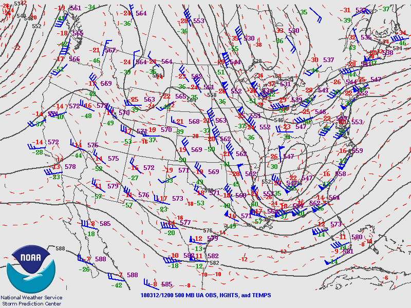
3/12/2018 8 AM EDT surface analysis with a surface low moving across the southern Appalachians and redeveloping over the southeast. | 3/11/2018 8 PM EDT 500 mb analysis (about 15,000 - 18,000 feet aloft) showing a shortwave trough moving across the lower OH Valley and TN Valley. This feature was the primary driver of the vertical motion and cooling that led to rain changing to snow across eastern KY. | 3/12/2018 8 AM EDT 500 mb analysis (about 15,000 - 18,000 feet aloft) showing the shortwave trough having closed off into an upper level low over the TN Valley and southern Appalachians. After this time, snow began to diminish across eastern KY. |
 |
Media use of NWS Web News Stories is encouraged! Please acknowledge the NWS as the source of any news information accessed from this site. |
|

