Temperatures - Warmer than Normal
- During Autumn 2024, average temperatures ranged from 49°F at Medford Taylor County Airport, WI (AWOS) to 55.2°F at Alma Dam 4, WI (COOP) in the Upper Mississippi River Valley.
- Temperature anomalies ranged from 3°F to 7°F warmer than normal.
- The hottest temperature was 92°F at Boscobel Airport, WI (ASOS) on September 15, and Decorah, IA (COOP) on September 21.
- The coldest temperature was 3°F at the Austin Waste Water Treatment Facility, MN (COOP) and Dodge Center Airport, MN on November 30.
|
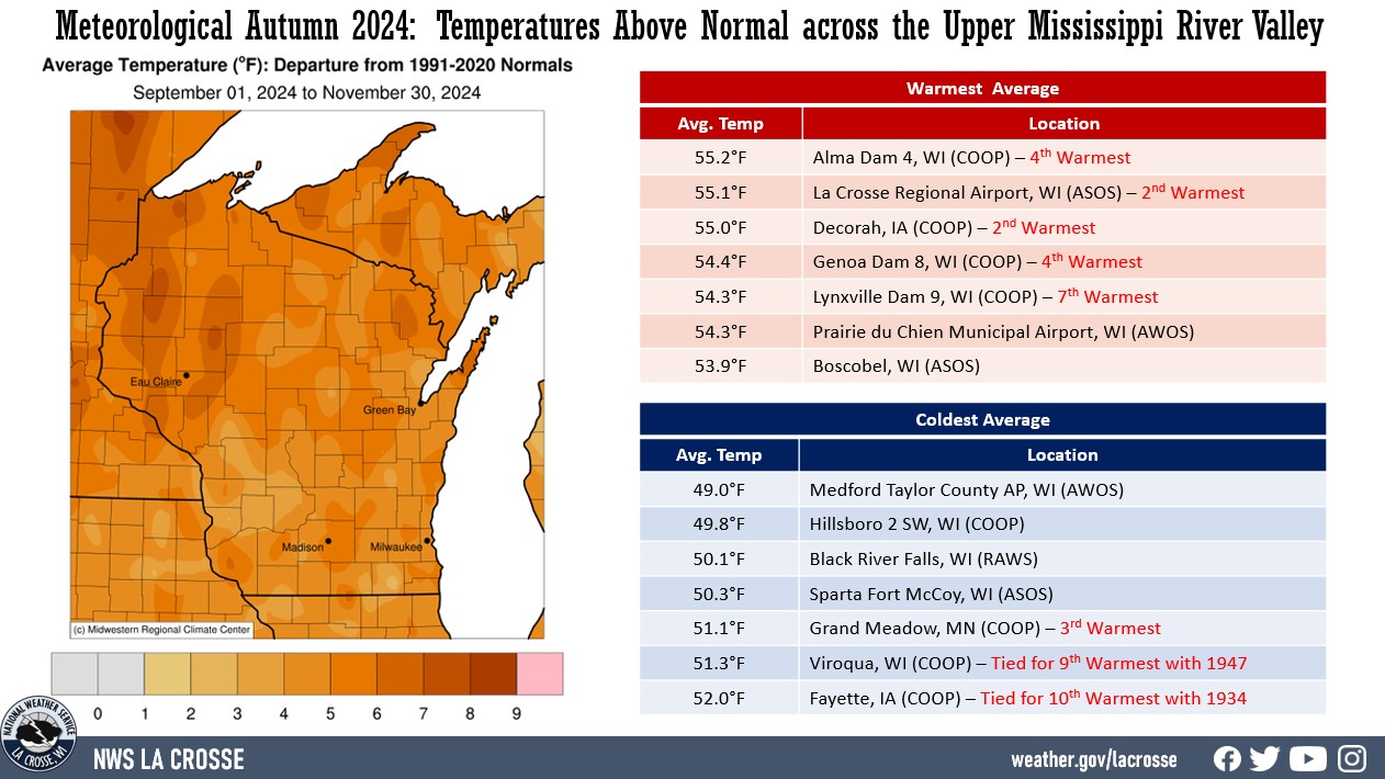 |
Several locations saw one of their 10 warmest autumns.
- 2nd Warmest - Decorah, IA & La Crosse, WI
- 3rd Warmest - Grand Meadow, MN
- 4th Warmest - Alma Dam 4, WI & Genoa Dam 8, WI
- 7th Warmest - Lynxville Dam 9, WI
- Tied for 9th Warmest - Viroqua, WI
- Tied for 10th Warmest - Fayette, IA
Precipitation - Highly Variable
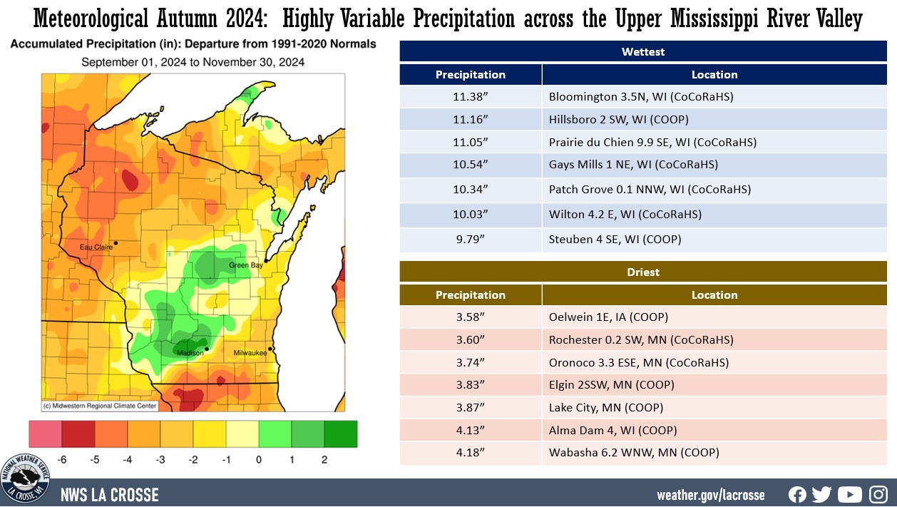
- During Autumn 2024, precipitation was highly variable across the Upper Mississippi River Valley.
- Precipitation varied from 3.58" near Oelwein, IA (COOP) to 11.38" near Bloomington WI (CoCoRaHS).
- Precipitation anomalies ranged from 5" below normal to 2" wetter than normal.
- The highest one-day precipitation was 3.11" near Platteville, WI (COOP) from October 30 through October 31.
|
 |
Snowfall:
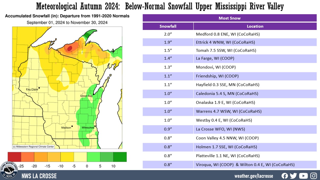
- Autumn snowfall ranged from a trace to 2" near Medford, WI (CoCoRaHS).
- These values were within 5 inches of normal.
- The snowiest day was 1.2" at La Farge, WI (COOP) from 7 AM on November 20 to 7 AM on November 21.
|
 |
The information below details meteorological autumn 2024 temperatures, precipitation, and snowfall for La Crosse WI, and Rochester MN.
La Crosse WI...
Meteorological Autumn of 2024 was much warmer (tied with 2015 for the 3rd warmest) and slightly drier than normal in La Crosse, WI. More details can be found below.
Temperatures - Tied for 3rd Warmest
- From September 1 through November 30, La Crosse Regional Airport had an average temperature of 55.1°F.
- This was 3.7°F warmer than the 1991-2020 normal of 51.4°F.
- This was tied with 2015 for the 3rd warmest autumn with 2015. Only 2016 (56.6°F - warmest) and 1931 (55.6°F - 2nd warmest) were warmer.
- The warmest temperature was 90°F on September 15 and the coldest temperature was 11°F on November 30.
|
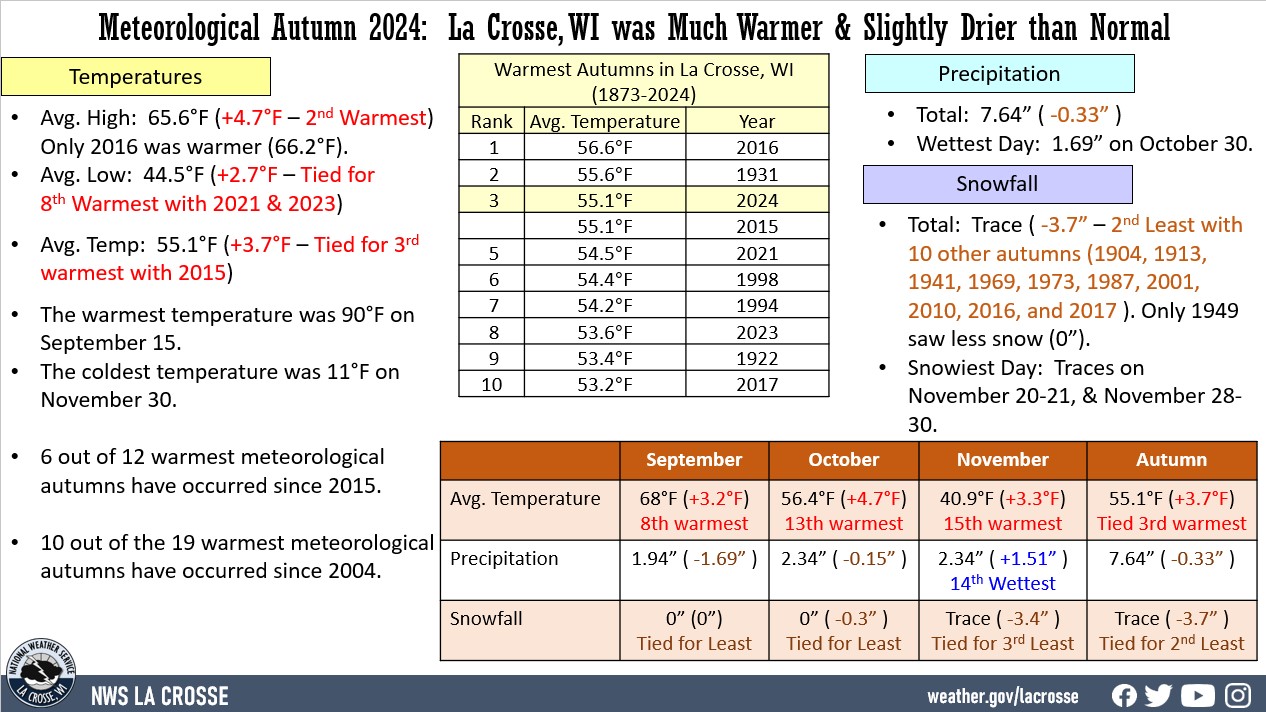 |
The table below lists the 10 warmest autumns for La Crosse, WI
Ten Warmest Autumns
in La Crosse, WI
1873-2023
Average
Rank Temperature Year
---- ----------- ----
1 56.6°F 2016
2 55.6°F 1931
3 55.1°F 2024
55.1°F 2015
5 54.5°F 2021
6 54.4°F 1998
7 54.2°F 1994
8 53.6°F 2023
9 53.4°F 1922
10 53.2°F 2017
- 6 out of 12 warmest meteorological autumns have occurred since 2015. 10 out of the 19 warmest meteorological autumns have occurred since 2004.
- The table below contains the monthly average temperatures and their departures from normal for the autumn of 2024.
Autumn 2024 Temperatures
in La Crosse WI
Average Departure
Month Temperature from Normal
----- ----------- -----------
September 68.0°F +3.2°F - 8th warmest
October 56.4°F +4.7°F - 13th warmest
November 40.9°F +3.3°F - 15th warmest
Autumn 55.1°F +3.7°F - Tied for 3rd warmest
- The average high temperature was 65.6°F which was 4.7°F warmer than the 1991-2020 normal of 60.9°F. This was the 2nd warmest. Only 2016 was warmer (66.2°F).
- The average low temperature was 44.5°F which was 2.7°F warmer than the 1991-2020 normal of 41.8°F. This was tied with 2021 and 2023 for 8th warmest.
- The warmest high temperature was 90°F on September 15.
- The coldest high temperature was 22°F on November 30.
- The warmest low temperature was 65°F on September 16.
- The coldest low temperature was 11°F on November 30.
- Temperatures averaged above normal on 62 days, below normal on 25 days, and normal on 4 days.
Precipitation - Slightly Drier than Normal
- From September 1 through November 30, La Crosse Regional Airport received 7.64" of precipitation.
- This was 0.33" drier than the 1991-2020 normal of 7.97".
- The table below contains the monthly precipitation totals and their departures from normal for the autumn of 2024.
Autumn 2024 Precipitation
in La Crosse WI
Precipitation Departure
Month Total from Normal
----- ------------- -----------
September 1.94 inches -1.69 inches
October 2.34 inches -0.15 inches
November 3.36 inches +1.51 inches - 14th Wettest
Autumn 7.64 inches -0.33 inches
- The highest daily precipitation total was 1.69" on October 30.
- Precipitation fell on 28 days (30.8%). Measurable rain fell on 18 days (19.8%), and trace amounts fell on another 10 days (11%).
Breakdown by precipitation amounts
None 63 Days (69.2%)
Trace 10 Days (11.0%)
0.01-0.09 inches 6 Days ( 6.6%)
0.10-0.24 inches 4 Days ( 4.4%)
0.25-0.49 inches 3 Days ( 3.3%)
0.50-0.99 inches 2 Days ( 2.2%)
1.00-1.99 inches 3 Day ( 3.3%)
Snowfall - Tied for 2nd Least
- From September 1 through November 30, the official snow observer near La Crosse Regional Airport received a trace of snow.
- This was 3.7" below the 1991-2020 normal of 3.7 inches. This was tied for 2nd least with 10 other autumns (1904, 1913, 1941, 1969, 1973, 1987, 2001, 2010, 2016, and 2017). Only 1949 saw less snow (0").
- The table below contains the monthly snowfall totals and their departures from normal for the autumn of 2024.
Autumn 2024 Snowfall
in La Crosse WI
Snowfall Departure
Month Total from Normal
----- ------------- -----------
September 0.0 inches 0.0 inches - Tied for Least
October 0.0 inches -0.3 inches - Tied for Least
November Trace -3.4 inches - Tied for 3rd Least
Autumn Trace -3.7 inches - Tied for 2nd Least
- The highest daily snowfall total was a trace on November 20-21, November 25, and November 28-30.
- A trace of snow fell on 6 days (6.6%). There was no measurable snow for the first time since 2017.
Breakdown by snowfall amounts
None 85 Days (93.4%)
Trace 6 Days ( 6.6%)
- The greatest snow depth was a trace on November 21.
Sky...
- It was clear on 57 days.
- It was partly cloudy on 23 days.
- It was cloudy on 11 days.
Sea Level Pressure...
- Highest was 30.56 inches on October 26.
- Lowest was 29.17 inches on November 19.
Winds...
- Highest sustained wind was 40 mph from the northwest on October 24.
- Highest wind gust was 54 mph from the northwest on October 24.
Rochester MN...
Meteorological autumn of 2024 much warmer and drier than normal at Rochester, MN. More details can be found below.
Temperatures - 3rd Warmest
- From September 1 through November 30, Rochester International Airport had an average temperature of 52.4°F.
- This was 4.9°F warmer than the 1991-2020 normal of 47.5°F.
- This made it the 3rd warmest autumn. Only 2016 (53.1°F - warmest) and 1963 (52.6°F - 2nd warmest) were warmer.
|
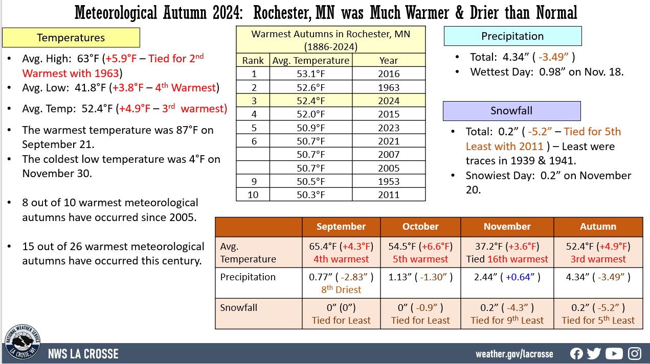 |
- The table below lists the 10 warmest autumns for Rochester, MN.
Ten Warmest Autumns
in Rochester MN
1886-2023
Average
Rank Temperature Year
---- ----------- ----
1 53.1°F 2016
2 52.6°F 1963
3 52.4°F 2024
4 52.0°F 2015
5 50.9°F 2023
6 50.7°F 2021
50.7°F 2007
50.7°F 2005
9 50.5°F 1953
10 50.3°F 2011
- 8 out of 10 warmest meteorological autumns have occurred since 2005.
- 15 out of 26 warmest meteorological autumns have occurred this century.
- The table below contains the monthly average temperatures and their departures from normal for the autumn of 2024.
Autumn 2024 Temperatures
in Rochester MN
Average Departure
Month Temperature from Normal
----- ----------- -----------
September 65.4°F +4.3°F - 4th Warmest
October 54.5°F +6.6°F - 5th Warmest
November 37.2°F +3.6°F - Tied for the
16th Warmest
Autumn 52.4°F +4.9°F - 3rd Warmest
- The average high temperature was 63°F which was 5.9°F warmer than the 1991-2020 normal of 57.1°F. This was tied with 1963 for the 2nd warmest.
- The average low temperature was 41.8°F which was 3.8°F warmer than the 1991-2020 normal of 38.0°F. This was the 4th warmest.
- The warmest high temperature was 87°F on September 21.
- The coldest high temperature was 18°F on November 30.
- The warmest low temperature was 63°F on September 14.
- The coldest low temperature was 4°F on November 30.
- Temperatures averaged above normal on 63 days, below normal on 24 days, and normal on 4 days.
Precipitation - Below Normal
- From September 1 through November 30, Rochester International Airport received 4.34" of precipitation.
- This was 3.49" drier than the 1991-2020 normal of 7.83".
- The table below contains the monthly precipitation totals and their departures from normal for the autumn of 2024.
Autumn 2024 Precipitation
in Rochester, MN
Precipitation Departure
Month Total from Normal
----- ------------- -----------
September 0.77 inches -2.83 inches - 8th Driest
October 1.13 inches -1.30 inches
November 2.44 inches +0.64 inches
Autumn 4.34 inches -3.49 inches - 22nd Driest
- The highest daily precipitation total was 0.98" on November 18.
- Precipitation fell on 25 days (27.5%). Measurable rain fell on 19 days (20.9%) and trace amounts fell on another 6 days (6.6%).
Breakdown by precipitation amounts
None 66 Days (72.5%)
Trace 6 Days ( 6.6%)
0.01-0.09 inches 9 Days ( 9.9%)
0.10-0.24 inches 3 Days ( 3.3%)
0.25-0.49 inches 5 Days ( 5.5%)
0.50-0.99 inches 2 Days ( 2.2%)
Snowfall - Below Normal
- From September 1 through November 30, the official snow observer near Rochester International Airport received 0.2" of snow.
- This was 5.2" below the 1991-2020 normal of 5.4".
- The table below contains the monthly snowfall totals and their departures from normal for the autumn of 2024.
Autumn 2024 Snowfall
in Rochester MN
Snowfall Departure
Month Total from Normal
----- ------------- -----------
September 0.0 inches 0.0 inches - Tied for Least
October 0.0 inches -0.9 inches - Tied for Least
November 0.2 inches -4.3 inches - Tied for 9th Least
Autumn 0.2 inches -5.2 inches - Tied for 5th Least
- The highest daily snowfall total was 0.2" on November 20.
- Snow fell 6 days (6.6%). Measurable snow fell on 1 day (1.1%) and trace amounts fell on another 5 days (5.5%).
Breakdown by snowfall amounts
None 85 Days (93.4%)
Trace 5 Days ( 5.5%)
0.1-0.9 inches 1 Day ( 1.1%)
- The greatest snow depth was a trace on November 21.
Sky...
- It was clear on 64 days.
- It was partly cloudy on 17 days.
- It was cloudy on 10 days.
Sea Level Pressure...
- Highest was 30.55 inches on October 26.
- Lowest was 29.14 inches on November 19.
Winds...
- Highest sustained wind was 35 mph on October 31 (northwest), November 16 (south), and November 19 (west).
- Highest wind gust was 52 mph on October 24 from the northwest.