
For Moderate/High/Extreme hazard risk, more detailed information will be provided via emailed briefings to core partners.
Red Flag Event Criteria |
|
1) Forest fuel conditions dry enough to support dangerous fire behavior. This shall be coordinated with the New Hampshire Forest Protection Bureau, and the Maine Forest Service.
|
|
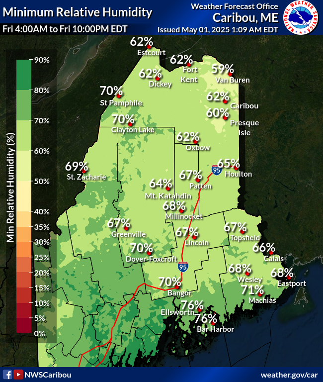
2) Weather conditions which could result in dangerous fire behavior: less than 30% humidity and frequent or sustained gusts above 25 mph.
|
| Note: Both forest and weather conditions must be expected to issue a Red Flag Warning. |
|
|
Day 1 Min RHMap displays minimum relative humidity values for the afternoon of Day 1. Map is updated every time the forecaster issues a new forecast. |
 |
Day 2 Min RHMap displays 24 hour minimum relative humidity values for the afternoon of Day 2. Map is updated every time the forecaster issues a new forecast.
|
Day 1 OutlookThe Day 1 Outlook covers the 24-hour period from 12Z on the morning of product issuance to 12Z the following morning, with the update covering the 19-hour period from 17Z at issuance to 12Z the following morning. |
Day 2 OutlookThe Day 2 Outlook covers the following 24-hour period after Day 1 out to 48 hours. The Day 2 Fire Weather Outlook is scheduled for issuance at 10Z and is updated at 20Z. |
 Day 3-8 Fire Wx Discussion Day 3-8 Fire Wx Discussion |
Day 3-8 OutlookThe Day 3-8 Outlook covers the period of 48 to 192 hours from 12Z on the morning of product issuance. The Day 3-8 Fire Weather Outlook is scheduled for issuance at 22Z. |
 use Firefox to view
|
Short-Range Ensemble Forecast (SREF)Short-Range Ensemble Forecast is produced by postprocessing the 21 members NCEP SREF plus the operational WRF-NAM for a total of 22 members. Special emphasis is placed on high-impact, mesoscale guidance including fire weather. |
Weather HazardsMap displays active watch, warnings, advisories and short term forecasts in the lower 48 states. Map automatically refreshes every five minutes. |
Surface AnalysisThe Weather Prediction Center (WPC) produces surface maps which depicts the analysis of highs, lows, fronts, troughs, outflow boundaries, squall lines, and drylines. |


 Coastal Flood
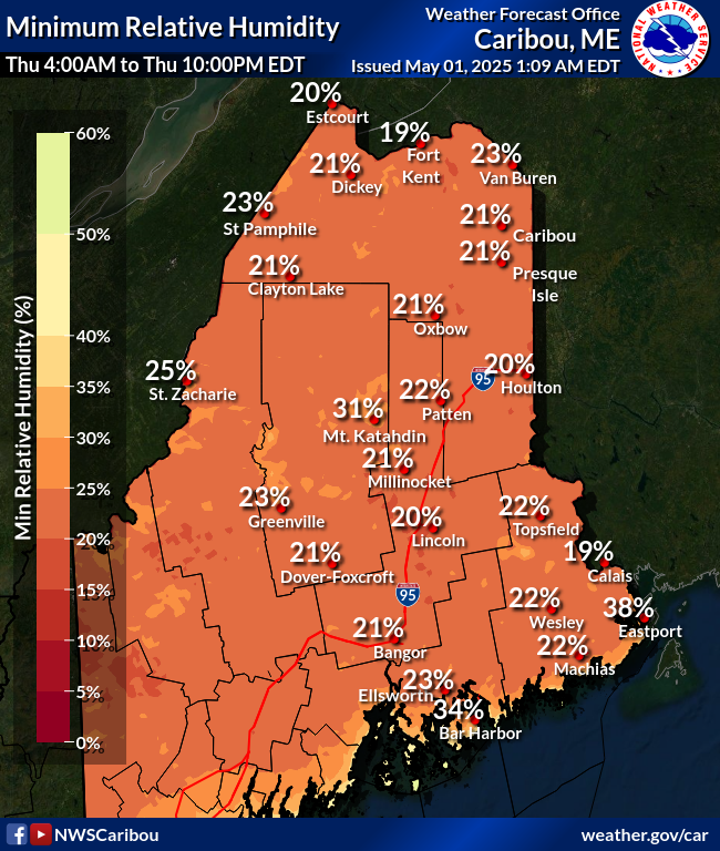