|
Summary
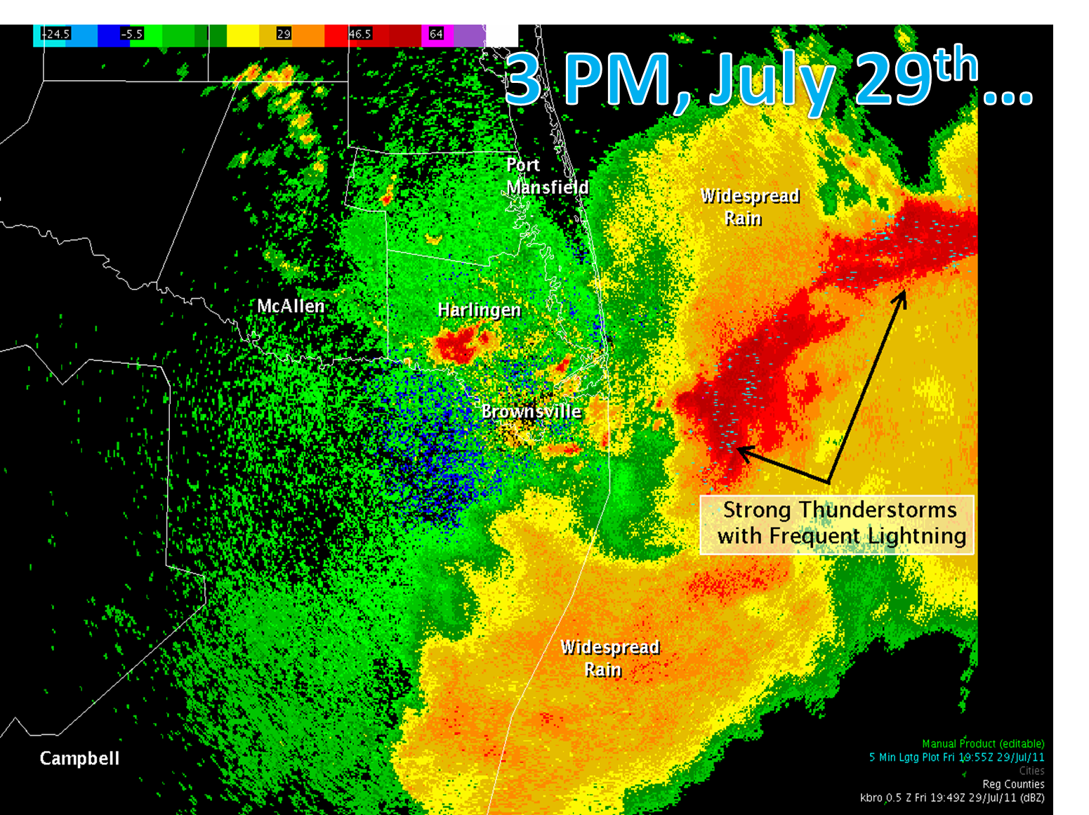
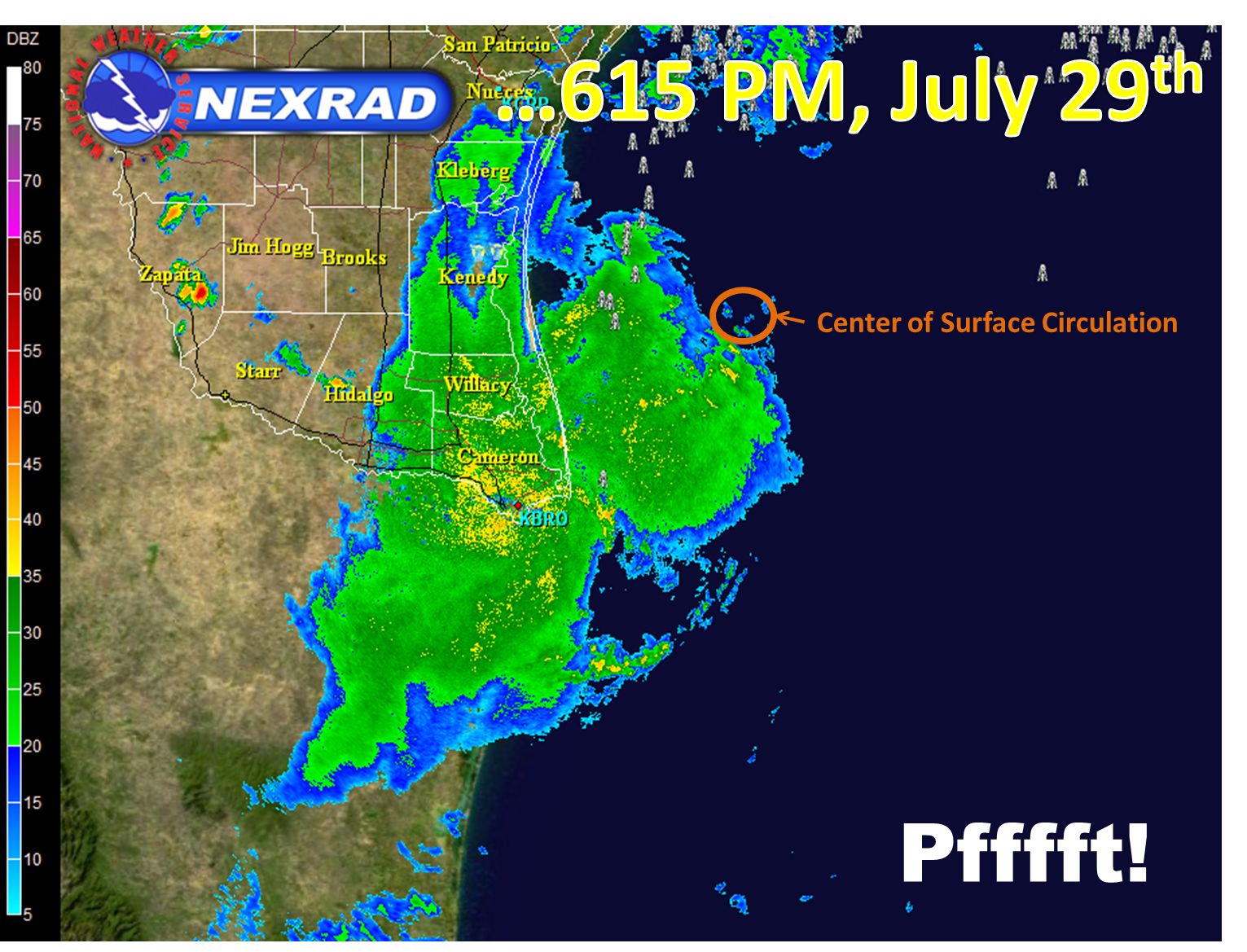
Tropical Storm Don failed to meet expectations compared with others before it (2010’s Hermine, for one), as a pronounced cluster of strong thunderstorms in and near the center (below, left) faded into oblivion in a matter of hours (below, right), leaving nothing more than gentle, light rains and light to nearly calm winds on land. By the time the surface circulation made landfall in northeastern Kenedy County, precipitation had largely ended across the Lower Rio Grande Valley and skies had begun to clear toward the coast. After the rain shield fell apart, leftover boundaries became active as the back end of the mid level circulation moved across Tamaulipas and Nuevo Léon into early morning of July 30th; locally heavy downpours in isolated to scattered showers and thunderstorms across the Rio Grande Plains and Brush Country of Zapata, Jim Hogg, and Starr County dropped close to an inch of rain in a short period of time between midnight and noon.
The only impacts on land were slippery roads and some ponding of water from South Padre Island to Brownsville and Harlingen during the Friday afternoon commute, along with a few cloud to ground lightning strikes. There were no known measured winds (sustained or gusts) reaching tropical storm force (39 mph). Coastal impacts were minimal; in fact, as the graying skies kept crowds from the beaches, surfers took full advantage of the clean and building surf, which rose high enough for rideable waves but without the tempest on the water that has accompanied other cyclones. The worst impacts were likely across the nearshore waters during the mid afternoon, when hundreds of cloud to ground lightning strikes, blinding rains, and locally rough seas made for difficulty for any mariners caught out in the cluster.
So, What Killed Don?
The answer seems simple. Or is it? Some small cyclones moving through warm waters often intensify rapidly, turning a relatively routine event into a life threatening windstorm (Charley, 2004). Others fail to intensify rapidly, and some lose their identity. Research into tropical cyclones is heavily invested in intensity prediction; much more study is needed to improve this critical aspect of forecasting. For Don, we observed three elements which may have led to Don’s struggle to survive, followed by the storm’s rapid demise:
- Dry Atmospheric Air. Don, being moved along by decent east to east–southeast flow in the mid levels of the atmosphere, quickly found inhospitable dry air along it’s path heading to Texas. Dry atmospheric air increases the amount of evaporation, and cooling, in and near the storm environment. While such cooling is favorable for atmospheric instability, it is unfavorable for the "heat engines" that drive tropical cyclones. Such cooling may have led to increased icing in the vertical growth region, leading to impressive cloud to ground lightning production. Most tropical cyclones have have much lower lightning strike frequencies than Don.
- Wind Shear. Just enough wind shear from north winds more than 25,000 feet above the ground elongated Don’s core, with the heaviest weather well south of the center of the surface circulation. When wind shear is combined with dry air in the same regions, the slightly tilted core takes on the personality of a mesoscale convective complex, where thunderstorms cluster in a circular fashion.
- Cool Nearshore Waters. A tropical cyclone struggling to intensify requires only a slight disruption to bring it down. Prior to Don’s arrival along the South Texas coast, surf zone water temperatures had dipped into the 70s to around 80°F, courtesy of a prolonged period of southeast flow which brought cooler undersea waters to the surface. Small thunderstorm clusters, which need warm, humid, unstable air to maintain their updrafts, can be destroyed by even a small area of stable air. Radar showed rapid decay of heavy rain, while satellite trends showed warming of the highest clouds. At the same time, hundreds of lightning strikes faded to dozens, then to only a few. All in less than three hours.
- Did Time of Day Matter? What might have occurred had the thunderstorm cluster approached the coast at 4 AM rather than 4 PM? In the past, energy from tropical waves arriving during the pre dawn hours have set off torrential rains, which begin before daybreak and continue until noon or so near the coast. One reason for this may be the increased instability (warm humid conditions) over the Gulf compared with cooler land just prior to daybreak. Could Don have done likewise, maintained it’s core, and dumped between 2 and 4 inches of rain along with gusty winds, 12 hours earlier (or later)?
We are planning to be part of future research efforts to investigate reasons, known and unknown, for Don’s rapid death.
Report
The text preliminary report can be found here. A table of precipitation, from highest to lowest, follows.
Table of Rainfall from Tropical Storm Don, July 29th through 7 AM July 30th 2011
|
City/Town
|
County
|
Rainfall (in.)
|
|
2.6 ESE Harlingen
|
Cameron
|
0.96
|
|
Hebbronville/Coop
|
Jim Hogg
|
0.85
|
|
4.1 E Brownsville
|
Cameron
|
0.71
|
|
0.7 E Rancho Viejo
|
Cameron
|
0.66
|
|
Brownsville/Intl Arpt
|
Cameron
|
0.63
|
|
Hebbronville/Arpt
|
Jim Hogg
|
0.61 (estimate)
|
|
5 SSE San Benito
|
Cameron
|
0.58
|
|
4.4 NE Brownsville
|
Cameron
|
0.57
|
|
Port Isabel Coop
|
Cameron
|
0.52
|
|
0.1 SSE Brownsville
|
Cameron
|
0.51
|
|
3.0 SE Rancho Viejo
|
Cameron
|
0.44
|
|
4.9 NNW Brownsville
|
Cameron
|
0.44
|
|
5 NW Brownsville
|
Cameron
|
0.44
|
|
0.3 NE Los Fresnos
|
Cameron
|
0.42
|
|
1.3 WNW Brownsville
|
Cameron
|
0.40
|
|
Alice Intl Arpt
|
Jim Wells
|
0.39
|
|
McCook/Coop
|
Hidalgo
|
0.39 (estimate)
|
|
Bayview
|
Cameron
|
0.36
|
|
Laguna Atascosa NWR
|
Cameron
|
0.35
|
|
4.7 WSW Harlingen
|
Cameron
|
0.29
|
|
Harlingen/Coop
|
Cameron
|
0.21
|
|
0.5 WNW Falfurrias
|
Brooks
|
0.21
|
|
8.9 SSW Falfurrias
|
Brooks
|
0.21
|
|
2.2 SW Palm Valley
|
Cameron
|
0.20
|
|
Harlingen/Valley Intl Arpt
|
Cameron
|
0.20
|
|
Kingsville NAS
|
Kleberg
|
0.16
|
|
Raymondville
|
Willacy
|
0.16
|
|
La Joya
|
Hidalgo
|
0.15
|
|
Falcon Lake RAWS
|
Starr
|
0.14
|
|
Weslaco Coop
|
Hidalgo
|
0.14 (estimate)
|
|
11 N La Joya
|
Hidalgo
|
0.13
|
|
Port Mansfield
|
Willacy
|
0.12
|
|
Mercedes 6 SSE
|
Hidalgo
|
0.12
|
|
2.4 NE McAllen
|
Hidalgo
|
0.12
|
|
1 NNE Alamo
|
Hidalgo
|
0.09
|
|
1.9 ENE Mission
|
Hidalgo
|
0.06
|
|
Sarita
|
Kenedy
|
0.05
|
|
Weslaco/Mid Valley Arpt
|
Hidalgo
|
0.04
|
|
Edinburg Coop
|
Hidalgo
|
0.03
|
|
San Manuel Coop
|
Hidalgo
|
0.02
|
|
McAllen/Miller Arpt
|
Hidalgo
|
0.01
|
|
McAllen/Water Plant
|
Hidalgo
|
0.01
|
|


