Temperatures:
| During the meteorological winter (December 1 through February 28) of 2022-23, average temperatures ranged from 16.7°F at Medford, WI (COOP) to 25.7°F at Boscobel Airport, WI (ASOS). These temperatures ranged from near-normal to 4°F warmer than normal. The largest departures were in Wisconsin. The warmest temperature was 54°F at Guttenberg Lock & Dam 10, IA, and near Lancaster, WI on December 30. The coldest temperature was -25°F at Black River Falls, WI (RAWS); at Preston, MN (COOP); and near Theilman, MN (COOP) on January 31; and southwest of Elkader, IA on February 1. | 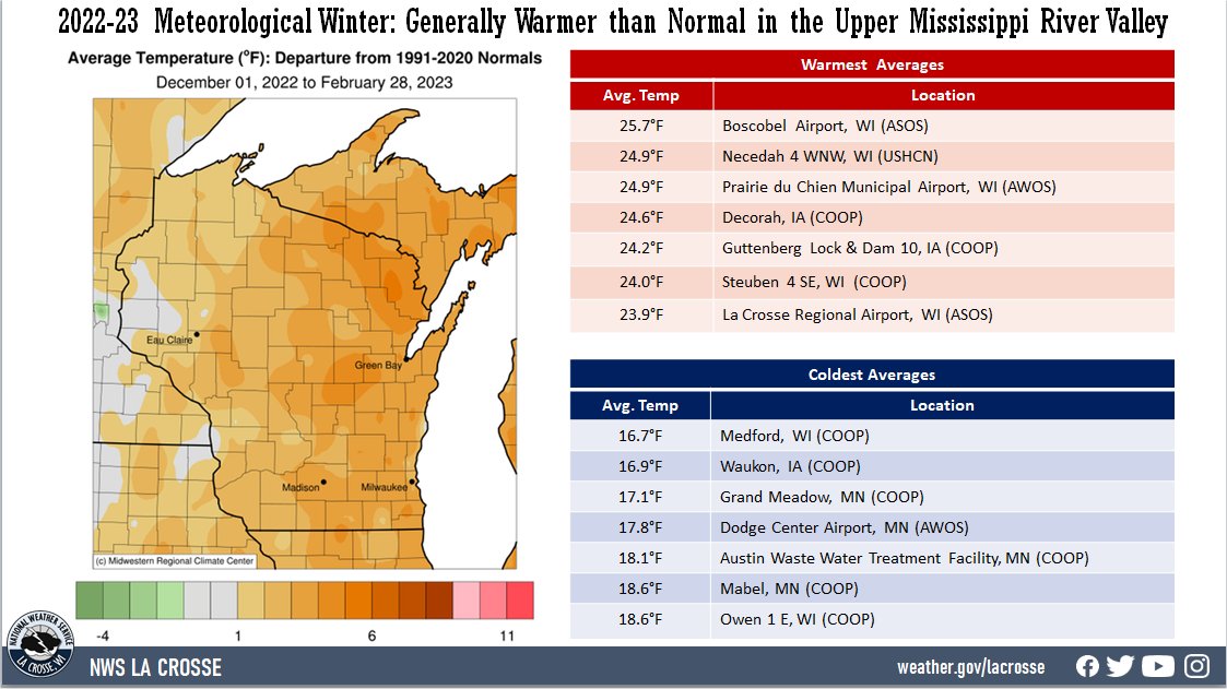 |
Precipitation:
| Precipitation ranged from 4.36" at Grand Meadow, MN (COOP) to 8.12" near Steuben, WI (COOP). These precipitation values ranged from near-normal to 4" wetter-than-normal. The following locations had their wettest winters La Cresent Dam 7, MN (7.83 inches); Prairie du Chien, WI (7.16 inches); Rochester, MN (6.57 inches) and Steuben, WI (8.12 inches). The greatest 1-day precipitation total was 1.68" near Mather, WI (COOP) from 7 am on December 14 to 7 am on December 15. | 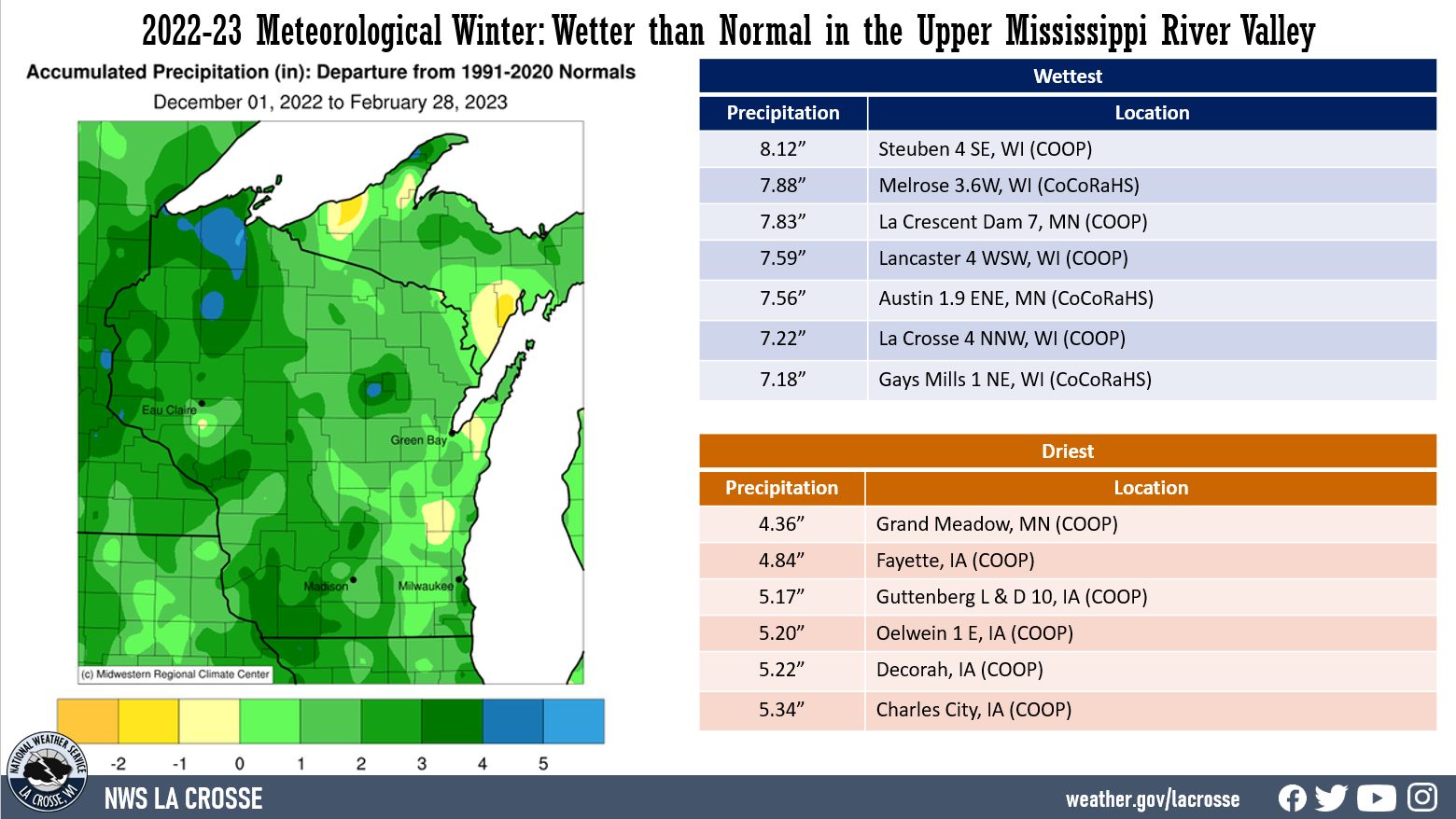 |
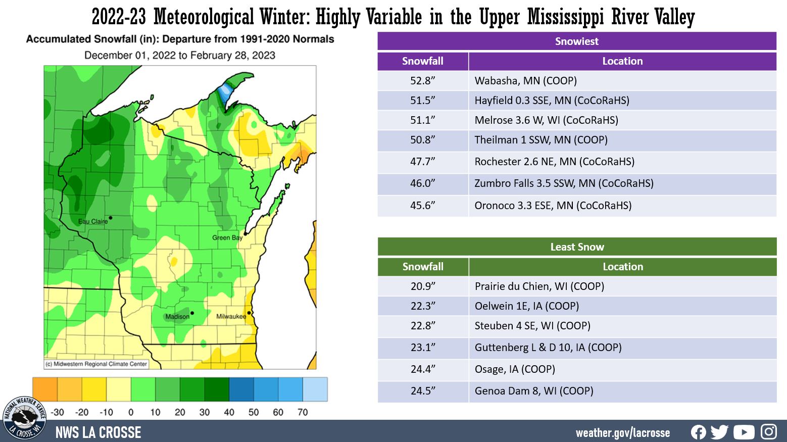
Snowfall:
|
Snowfall ranged from 20.9" at Prairie du Chien, WI (COOP) to 52.8" at Wabasha, MN (COOP). These snowfall values ranged from 15" below normal to 20" above normal. Rochester, MN had its 11th snowiest meteorological winter. The greatest 1-day snowfall total was 1.68" near Mather, WI (COOP) from 7 am on December 14 to 7 am on December 15. The greatest 1-day snowfall was 13.2" at Theilman, MN (COOP). This snow fell from 7 AM on February 22 to 7 AM on February 23. This was the snowiest February day there. The previous record was 12.2" on February 24, 2019. |
 |
Below are climate summaries for La Crosse, WI, and Rochester, MN.
Temperatures - Warmest Since the Winter of 2019-20
|
 |
The table below contains the monthly temperatures and their departures from normal for the winter of 2022-23.
Winter 2022-23 Temperatures
in La Crosse WI
Average Departure
Month Temperature from Normal
----- ----------- -----------
December 21.5°F - 3.6°F
January 24.4°F + 5.5°F - 14th Warmest
February 26.1°F + 2.8°F
Winter 24.0°F + 1.5°F
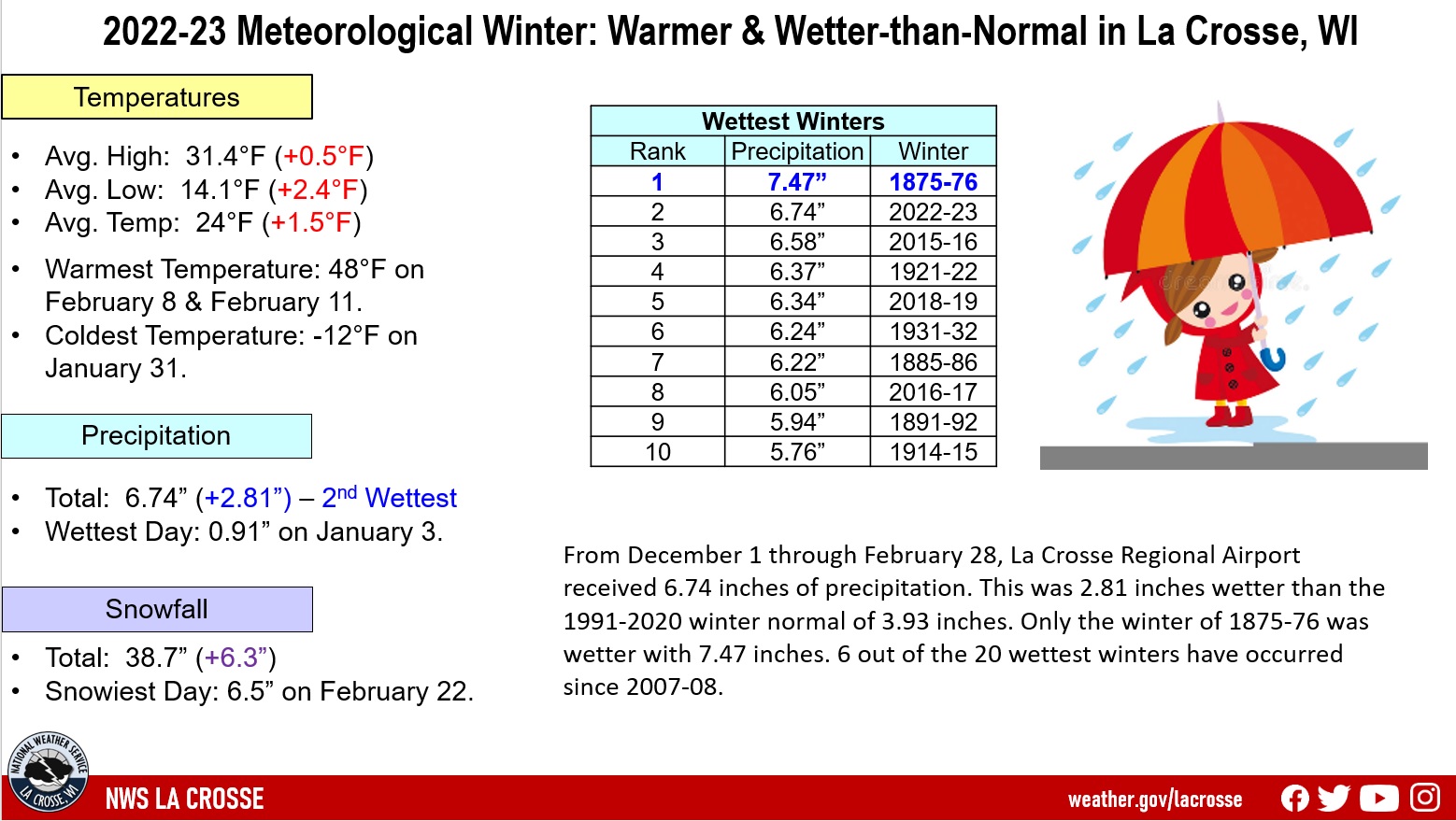
Precipitation - 2nd Wettest
10 Wettest Meteorological
Winters for La Crosse, WI
1872-2023
Rank Precipitation Winters
---- ------------- -------
1 7.47 inches 1875-76
2 6.74 inches 2022-23
3 6.58 inches 2015-16
4 6.37 inches 1921-22
5 6.34 inches 2018-19
6 6.24 inches 1931-32
7 6.22 inches 1885-86
8 6.05 inches 2016-17
9 5.94 inches 1891-92
10 5.76 inches 1914-15
The table below contains the monthly precipitation totals and their departures from normal for the winter of 2022-23.
Winter 2022-23 Precipitation
in La Crosse WI
Precipitation Departure
Month Total from Normal
----- ------------- -----------
December 2.38 inches +0.89 inches - 14th Wettest
January 2.17 inches +0.92 inches - 17th Wettest
February 2.19 inches +1.00 inches - 12th Wettest
Winter 6.74 inches +2.81 inches - 2nd Wettest
Snowfall - Above Normal
From December 1 through February 28, the snow observer near La Crosse Regional Airport received 38.7 inches of snow. This was 6.3 inches above 1991-2020 normal of 32.4 inches.
The table below contains the monthly snowfall totals and their departures from normal for the winter of 2022-23.
Winter 2022-23 Snowfall
in La Crosse WI
Snowfall Departure
Month Total from Normal
----- ------------ -----------
December 17.0 inches +6.1 inches - 18th Snowiest
January 10.2 inches -1.6 inches
February 11.5 inches +1.8 inches
Winter 38.7 inches +6.3 inches
Snow Depth - Below Average
From December 1 through February 28, the official snow observer near La Crosse Regional Airport had an average snow depth of 3.9 inches. This was 0.5 inches lower than the long-term average (1893-2023) of 4.4 inches.
The greatest snow depth was 10 inches on February 24-25.
There was snow on the ground on 77 days (85.6 percent) this winter. Measurable snow was on the ground on 68 days (75.6 percent) and trace amounts of snow on the ground on 9 days (9.9 percent).
Sky Cover
Clear Days - 28 days (Normal 22 days)
Partly Cloudy Days - 31 days (Normal 20 days)
Cloudy Days - 31 days (Normal 48 days)
Winds
Barometric Pressure
Temperatures - Warmer than Normal
|
 |
Precipitation - Wettest
10 Wettest Meteorological
Winters for Rochester MN
1886-2023
Rank Precipitation Winters
---- ------------- -------
1 6.57 inches 2022-23
2 6.30 inches 2018-19
3 5.85 inches 2016-17
4 5.47 inches 1887-88
5 5.29 inches 2010-11
6 4.92 inches 1982-83
7 4.69 inches 1950-51
8 4.61 inches 2015-16
9 4.29 inches 1932-33
10 4.25 inches 1966-67
The table below contains the monthly precipitation totals and their departures from normal for the winter of 2022-23.
Winter 2022-23 Precipitation
in Rochester MN
Precipitation Departure
Month Total from Normal
----- ------------- -----------
December 1.62 inches +0.34 inches
January 2.41 inches +1.42 inches - 3rd Wettest
February 2.54 inches +1.52 inches - 2nd Wettest
Winter 6.57 inches +3.29 inches - Wettest
Snowfall...11th Snowiest
20 Snowiest Meteorological
Winters for Rochester MN
1939-2023
Rank Snowfall Winters
---- -------- -------
1 68.2 inches 2018-19
2 60.4 inches 2010-11
3 50.0 inches 2000-01
4 48.1 inches 1969-70
5 46.5 inches 2013-14
6 46.4 inches 2008-09
7 45.8 inches 1996-97
8 44.4 inches 2009-10
9 43.9 inches 1995-96
10 43.6 inches 1978-79
11 43.4 inches 2022-23
12 43.3 inches 2016-17
13 43.1 inches 1993-94
14 43.0 inches 1970-71
15 40.6 inches 1981-82
16 40.1 inches 1998-99
17 40.0 inches 2003-04
40.0 inches 1987-88
40.0 inches 1950-51
20 39.9 inches 1961-62
The table below contains the monthly snowfall totals and their departures from normal for the winter of 2022-23.
Winter 2022-23 Snowfall
in Rochester MN
Snowfall Departure
Month Total from Normal
----- ------------ -----------
December 18.3 inches +5.9 inches
Tied for 12th Snowiest
January 11.5 inches -0.7 inches
February 13.6 inches +2.9 inches
Winter 43.4 inches +8.1 inches - 14th Snowiest
Snow Depth...Above Average
From December 1 through February 28, the official snow observer near Rochester International Airport had an average snow depth of 5.8 inches. This was 0.6 inches higher than the long-term average (1938-2023) of 5.2 inches.
The greatest snow depth was 12 inches on December 22-27 and February 24-26.
There was snow on the ground on 84 days (93.3 percent) this winter. Measurable snow was on the ground on 79 days (87.8 percent) and trace amounts of snow on the ground on 5 days (5.6 percent).
Sky Cover
Clear Days - 32 days (Normal 20 days)
Partly Cloudy Days - 31 days (Normal 20 days)
Cloudy Days - 27 days (Normal 50 days)
Winds
Barometric Pressure


 Weather Story
 Weather Map
 Local Radar