Upper Mississippi River Climate Summary for Astronomical Winter 2024-25:
Temperatures - Near to Above Normal
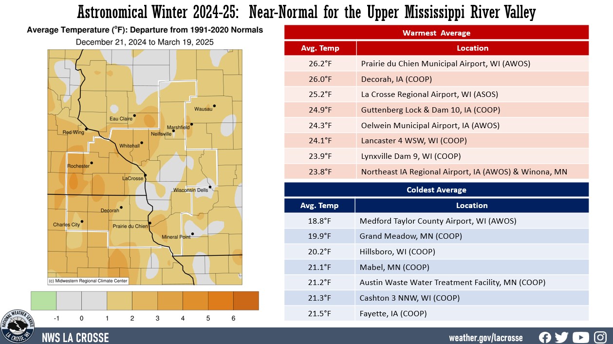
- During the astronomical winter of 2024-25, temperatures in the Upper Mississippi River Valley ranged from 18.8°F at Medford Taylor County Airport (AWOS) to 26.2°F at Prairie du Chien Municipal Airport (AWOS).
- Temperature anomalies ranged from near-normal to 5°F warmer than normal.
- There was a 109°F difference between the warmest and coldest temperatures in the Upper Mississippi River Valley.
- The warmest temperature was 81°F at Prairie du Chien, WI (COOP & AWOS) and Sparta Fort McCoy Airport, WI (AWOS) on March 14.
- Meanwhile, the coldest temperature was -28°F at Black River Falls, WI (RAWS) on February 18.
|
 |
Precipitation - Near to Drier than Normal
- Precipitation totals ranged from 2.18" at Alma Dam 4, WI (COOP) to 5.43" near Warrens, WI (CoCoRaHS).
- Precipitation anomalies ranged from 3" drier than normal to 1" wetter than normal.
- The highest one-day precipitation was 1.70" near Brownsville, MN (CoCoRaHS) from March 18 through March 19.
- Abnormally dry (D0) to moderate (D1) drought conditions changed little across the NWS La Crosse Hydrologic Service Area (HSA) during the winter.
|
 |
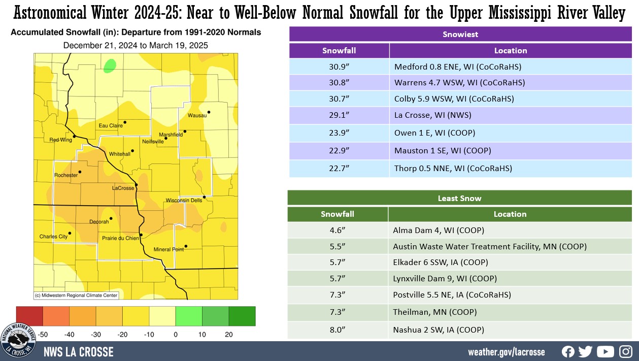
Snowfall - Below Normal
- Snowfall totals were highly variable. They ranged from 4.6" at Alma Dam 4, WI (COOP) to 30.9" near Medford, WI (CoCoRaHS).
- Snowfall anomalies ranged from near normal to 30" below normal.
- The highest one-day snowfall was 9.6" near Mather, WI on March 19.
|
 |
Here are more details on the winter for La Crosse WI and Rochester MN...
La Crosse WI...
During the astronomical winter (December 21 through March 19), La Crosse Regional Airport was warmer and slightly drier than average. The information below provides more details on these statistics.
Temperatures - 25th Warmest
- During astronomical winter, temperatures averaged 25.2°F at La Crosse Regional Airport.
- This was 4.2°F warmer than the long-term (1872-2025) average of 21°F.
- This was the 25th warmest astronomical winter.
- 9 out the last 11 astronomical winters have warmer than the long-term average. This includes the 2nd warmest (2023-24), 5th warmest (2016-17), 11th warmest (2019-20), 15th warmest (2015-16), 25th (2024-25), and 29th warmest (2022-23).
|
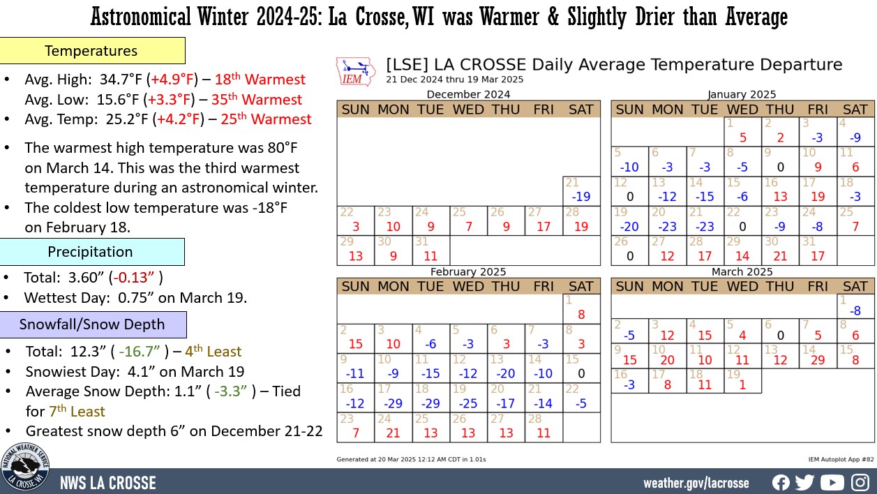 |
- The average high temperature was 34.7°F. This was 4.9°F warmer than the long-term average of 29.8°F. This was the 18th warmest.
- The average low temperature was 15.6°F. This was 3.3°F warmer than the long-term average of 12.3°F. This was the 35th warmest.
- The warmest high temperature was 80°F on March 14. This was the 3rd warmest during an astronomical winter. The warmest temperature in astronomical winter was 83°F (March 17) during the astronomical winter of 2011-12. The second warmest was 82°F (March 7) in 1999-2000.
- The coldest high temperature was -1°F on January 20.
- The warmest low temperature was 49°F on March 14.
- The coldest low temperature was -18°F on February 18.
Precipitation - Slightly Below Average
- During astronomical winter, a total of 3.60" of precipitation fell at La Crosse Regional Airport.
- This was 0.13" drier than the long-term (1872-2025) average of 3.73".
- The wettest day occurred on March 19 when 0.75" of precipitation fell.
- Measurable (0.01" or greater) precipitation fell on 21 days (23.6%) and trace amounts of precipitation fell on another 20 days (22.5%).
Snowfall - 4th Least
-
During astronomical winter, a total of 12.3" of snow was measured by the official NWS snow observer near La Crosse Regional Airport.
-
This was 16.7" below the long-term (1896-2025) average of 29.0".
This was the 4th least and the least amount of snow in astronomical winter since 1967-68 (5.6 inches - least). Below are the ten astronomical winters with the least amount of snow for La Crosse, WI.
10 Least Amount of Snow
in an Astronomical Winter
for La Crosse, WI
1896-2024
Rank Snowfall Winters
---- -------- -------
1 5.6 inches 1967-68
2 11.7 inches 1957-58
3 11.8 inches 1933-34
4 12.3 inches 2024-25
5 13.0 inches 1953-54
6 13.3 inches 1983-84
7 13.4 inches 1902-03
8 13.7 inches 1954-55
13.7 inches 1947-48
10 14.5 inches 1963-64
- The snowiest day occurred on March 19 when 4.1" of snow fell.
- Measurable (0.1 inches or greater) snow fell on 11 days (12.4%) and trace amounts of snow fell on another 18 days (20.2%).
Snow Depth - Tied for 7th Least
- During astronomical winter, the average snow depth measured by the official NWS snow observer was 1.1".
- This was 3.3" below the long-term (1893-2025) average of 4.4".
- This was tied for the 7th least in a meteorological winter with 1930-31, 1957-58, 1980-81, 1989-90, and 2001-02.
- Below are the ten astronomical winters with the least snow depth average for La Crosse, WI.
10 Lowest Avg. Snow Depth
in an Astronomical Winter
for La Crosse, WI
1896-2024
Rank Snow Depth Winters
---- ---------- -------
1 0.4 inches 1967-68
0.4 inches 1932-33
3 0.5 inches 1933-34
4 0.7 inches 1943-44
5 0.9 inches 1963-64
6 1.0 inches 1994-95
7 1.1 inches 2024-25
1.1 inches 2001-02
1.1 inches 1989-90
1.1 inches 1980-81
1.1 inches 1957-58
1.1 inches 1930-31
- Measurable snow was on the ground on 25 days or 28.1% of the season.
- A trace of snow was on the ground on 11 days or 12.4% of the season.
- There was no snow on the ground for 53 days or 59.6% of the season.
- The greatest snow depth was 6" on December 21-22.
Rochester MN...
During the astronomical winter (December 21 through March 19), Rochester International Airport warmer than average with near average precipitation. The information below provides more details on these statistics.
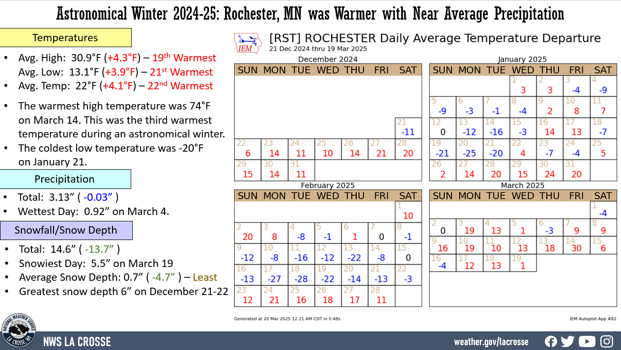
Temperatures - 22nd Warmest
- During astronomical winter, temperatures averaged 22°F at Rochester International Airport.
- This was 4.1°F warmer than the long-term (1886-2025) average of 17.9°F.
- This was the 22nd warmest astronomical winter.
- 5 out of the last 6 astronomical winters have been warmer than the long-term average.
|
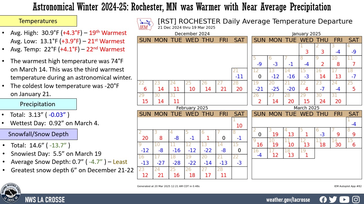 |
- The average high temperature was 30.9°F. This was 4.3°F warmer than the long-term average of 26.6°F. This was the 19th warmest.
- The average low temperature was 13.1°F. This was 3.9°F warmer than the long-term average of 9.2°F. This was the 21st warmest.
- The warmest high temperature was 74°F on March 14. This was tied for 3rd warmest during an astronomical winter with 2023-24 (74°F - March 11). Only the winters of 1999-2000 (75°F - March 7) and 2011-12 (81°F - March 17) had a warmer high temperature for an astronomical winter.
- The coldest high temperature was -5°F on January 20.
- The warmest low temperature was 48°F on March 14. This was tied for the 3rd warmest in a meteorological winter with 1994-95 (48°F on March 13). Only the winters of 2011-12 (62°F - March 19) and 1999-2000 (49°F - March 7) had a warmer low temperature for an astronomical winter.
- The coldest low temperature was -20°F on January 21.
Precipitation - Near Average
- During astronomical winter, a total of 3.13" of precipitation fell at Rochester International Airport.
- This was 0.03" wetter than the long-term (1886-2025) average of 3.10".
- The wettest day occurred on March 4 when 0.92" of precipitation fell.
- Measurable (0.01" or greater) precipitation fell on 17 days (19.1%) and trace amounts of precipitation fell on another 22 days (24.7%).
Snowfall - Below Average
- During astronomical winter, a total of 14.6" of snow was measured by the official NWS snow observer near Rochester International Airport. This was 13.7" below the long-term (1909-2025) average of 28.3".
- The snowiest day occurred on March 19 when 5.5" of snow fell.
- Measurable (0.1" or greater) snow fell on 12 days (13.5%) and trace amounts of snow fell on another 16 days (18%).
Snow Depth - Least Average
- During astronomical winter, the average snow depth measured by the official NWS snow observer near Rochester International Airport was 0.7".
- This was 4.7" lower than the long-term (1938-2025) average of 5.4". This was the least in an astronomical winter.
- The previous record was 0.8" in 1956-57, 1967-68, and 2011-12.
- Below are the ten astronomical winters with the lowest average snow depth for Rochester, MN.
10 Lowest Avg. Snow Depth
in an Astronomical Winter
for Rochester, MN
1909-2025
Rank Snowfall Winters
---- -------- -------
1 0.7 inches 2024-25
2 0.8 inches 2011-12
0.8 inches 1967-68
0.8 inches 1956-57
5 0.9 inches 1963-64
6 1.0 inches 2023-24
1.0 inches 1957-58
8 1.2 inches 1986-87
1.2 inches 1953-54
10 1.4 inches 2002-03
- Measurable snow was on the ground for 23 days or 25.8% of the season.
- A trace of snow was on the ground on 10 days or 11.2% of the season.
- There was no snow on the ground on 56 days or 62.9% of the season.
- The greatest snow depth was 6" from December 21-22.