Upper Mississippi River Climate Summary for Meteorological Winter 2023-24:
Temperatures - Well Above-Normal
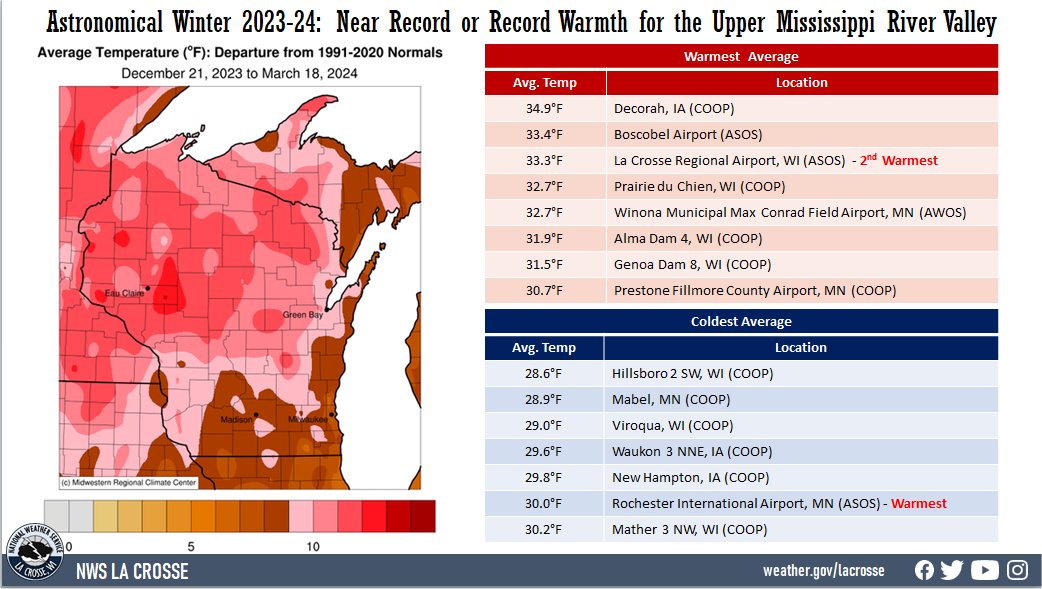
- During the astronomical winter of 2023-24, temperatures in the Upper Mississippi River Valley ranged from 28.6°F near Hillsboro, WI (COOP) to 34.9°F at Decorah, IA (COOP). Temperature anomalies ranged from 8 to 12°F warmer than normal. Many locations had record or near-cord warmth. There was a 105°F difference between the warmest and coldest temperatures in the Upper Mississippi River Valley. The warmest temperature was 78°F at Boscobel Airport, WI on March 4. Meanwhile, the coldest temperature was -27°F at Theilman, MN (COOP) on January 20.
|
 |
Precipitation - Below Normal
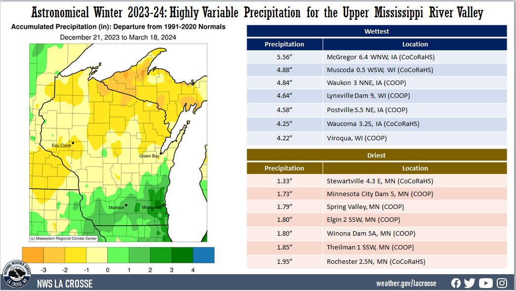
- Precipitation totals ranged from 1.33" near Stewartville, MN (CoCoRaHS) to 5.56" near McGregor, IA (CoCoRaHS). Precipitation anomalies ranged from 2" drier than normal to 2" wetter than normal. The highest one-day precipitation was 1.22" south of Mondovi, WI (CoCoRaHS) from December 25 through December 26.
- Moderate (D1) to extreme (D3) drought lingers expanded during astronomical winter from 65% to 90% of the NWS La Crosse Hydrologic Service Area (HSA).
|
 |
Snowfall - Below Normal
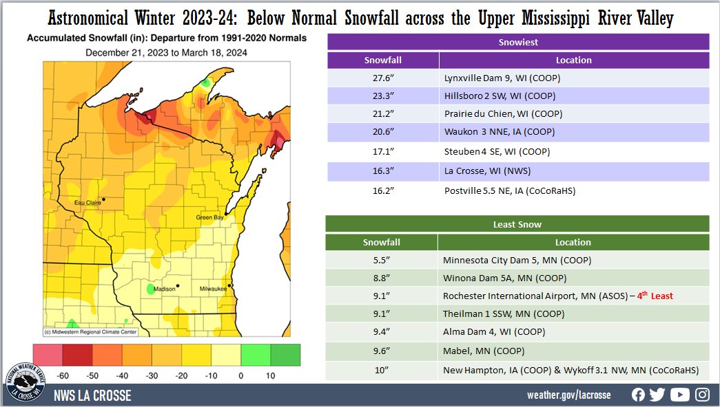
- Snowfall totals were highly variable. They ranged from 5.5" at Minnesota City Dam 5, MN (COOP) to 27.6" at Lynxville Dam 9, WI (COOP). Snowfall anomalies ranged from near normal to 30" below normal. The highest one-day snowfall was 12.5" at La Farge, WI (COOP) from January 12 through January 13.
|
 |
Here are more details on the winter for La Crosse WI and Rochester MN...
La Crosse WI...
During the astronomical winter (December 21 through March 18), La Crosse Regional Airport was drier and much warmer than average. The information below provides more details on these statistics.
Temperatures - 2nd Warmest
- During astronomical winter, temperatures averaged 33.3°F at La Crosse Regional Airport. This was 12.3°F warmer than the long-term (1872-2023) average of 21°F. This was the 2nd warmest astronomical winter. Only the winter of 1877-78 was warmer with an average temperature of 36.5°F.
|
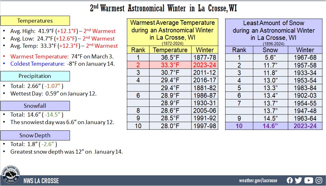 |
- Below are the 10 warmest astronomical winters.
Warmest Astronomical Winters
in La Crosse, WI
1872-2024
Rank Avg Temperature Winter
---- --------------- ------
1 36.5°F 1877-78
2 33.3°F 2023-24
3 30.7°F 2011-12
4 29.4°F 2016-17
29.4°F 1881-82
6 28.9°F 1986-87
28.9°F 1930-31
8 28.6°F 2005-06
9 28.5°F 1991-92
10 28.0°F 1997-98
- This was only the 2nd winter to see an average temperature above freezing. 8 out of the last 10 astronomical winters have been warmer than the long-term average. This included the 2nd (2023-24), 4th (2016-17 - tied with 1881-82) and the 11th (2019-20) warmest astronomical winters.
- The average high temperature was 41.9°F. This was 12.1°F warmer than the long-term average of 29.8°F. This was the 2nd warmest. Only 1877-78 was warmer with an average temperature of 43.4°F.
- The average low temperature was 24.7°F. This was 12.6°F warmer than the long-term average of 12.3°F. This was the 2nd warmest. Only 1877-78 was warmer with an average temperature of 29.7°F.
- The warmest high temperature was 74°F on March 3. This was tied for the 6th warmest during an astronomical winter with the winters of 1986-87 (March 7) and 1989-90 (March 12). The warmest temperature in astronomical winter was 83°F during the astronomical winter of 2011-12 (March 17).
- The coldest high temperature was 2°F on January 14.
- The warmest low temperature was 50°F on December 25.
- The coldest low temperature was -8°F on January 14, January 15, and January 20.
Precipitation - Below Average
- During astronomical winter, a total of 2.66" of precipitation fell at La Crosse Regional Airport. This was 1.07" drier than the long-term (1872-2024) average of 3.73".
- The wettest day occurred on January 12 when 0.59" of precipitation fell.
- Measurable (0.01" or greater) precipitation fell on 18 days (20.2%) and trace amounts of precipitation fell on another 13 days (14.6%).​
Snowfall - Below Average
- During astronomical winter, a total of 14.6" of snow was measured by the official NWS snow observer near La Crosse Regional Airport.
- This was 14.5" below the long-term (1896-2024) average of 29.1".
- This was the 10th least and the least amount of snow in astronomical winter since 1983-84 (13.3" - 5th least).
- Below are the ten astronomical winters with the least amount of snow for La Crosse, WI.
10 Least Amount of Snow
in an Astronomical Winter
for La Crosse, WI
1896-2024
Rank Snowfall Winters
---- -------- -------
1 5.6 inches 1967-68
2 11.7 inches 1957-58
3 11.8 inches 1933-34
4 13.0 inches 1953-54
5 13.3 inches 1983-84
6 13.4 inches 1902-03
7 13.7 inches 1954-55
13.7 inches 1947-48
9 14.5 inches 1963-64
10 14.6 inches 2023-24
- The snowiest day occurred on January 12 when 6.6" of snow fell.
- Measurable (0.1" or greater) snow fell on 9 days (10.1%) and trace amounts of snow fell on another 10 days (11.2%).
Snow Depth - Below Normal
- During astronomical winter, the average snow depth measured by the official NWS snow observer was 1.8". This was 2.6" below the long-term (1893-2024) average of 4.4".
- Measurable snow was on the ground on 24 days or 27% of the season.
- A trace of snow was on the ground on 5 days or 5.6% of the season.
- There was no snow on the ground for 60 days or 67.4% of the season.
- The greatest snow depth was 12" between January 14.
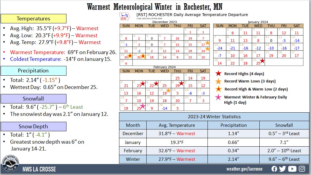
Rochester MN...
During the astronomical winter (December 21 through March 18), Rochester International Airport was drier and much warmer than average. The information below provides more details on these statistics.
Temperatures - Warmest
- During astronomical winter, temperatures averaged 30°F at Rochester International Airport. This was 12.1°F warmer than the long-term (1886-2023) average of 17.9°F. This was the warmest astronomical winter. The previous record was 29.5°F in 2011-12.
|
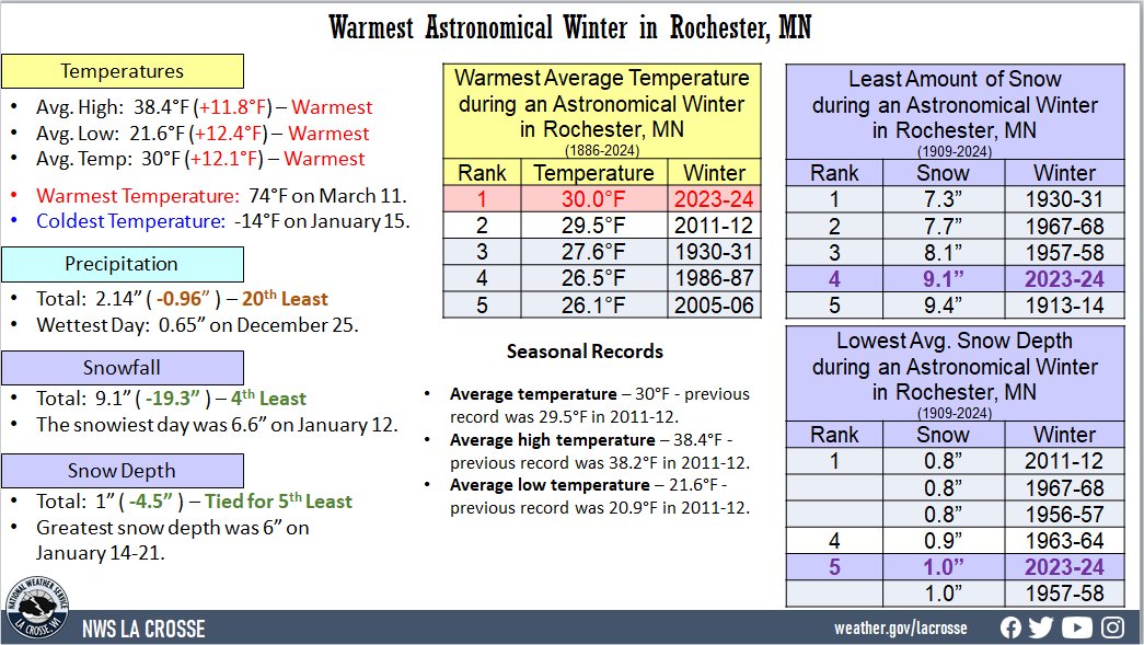 |
- Below are the 10 warmest astronomical winters.
Warmest Astronomical Winters
in Rochester MN
1886-2024
Rank Avg Temperature Winter
---- --------------- ------
1 30.0°F 2023-24
2 29.5°F 2011-12
3 27.6°F 1930-31
4 26.5°F 1986-87
5 26.1°F 2005-06
6 25.8°F 1991-92
7 24.9°F 1989-90
8 24.2°F 1982-83
9 24.1°F 2016-17
10 23.6°F 1999-2000
- 4 out of the last 5 astronomical winters have been warmer than the long-term average.
- The average high temperature was 38.4°F. This was 11.8°F warmer than the long-term average of 26.6°F. The previous record was 38.2 inches in 2011-12.
- The average low temperature was 21.6°F. This was 12.4°F warmer than the long-term average of 9.2°F. The previous record was 20.9 inches in 2011-12.
- The warmest high temperature was 74°F on March 11. This was 3rd warmest during an astronomical winter. Only the winters of 1999-2000 (75°F - March 7) and 2011-12 (81°F - March 17) had a warmer high temperature for astronomical winter.
- The coldest high temperature was -5°F on January 14.
- The warmest low temperature was 44°F on December 24, December 25, and March 12.
- The coldest low temperature was -14°F on January 15.
Precipitation - 20th Driest
- During astronomical winter, a total of 2.14" of precipitation fell at Rochester International Airport.
- This was 0.96" drier than the long-term (1886-2023) average of 3.10".
- This was the 20th driest astronomical winter and the driest since 2008-2009 (1.96" - tied with 1990-91 for the 16th driest winter).
- Below are the 20 driest astronomical winters.
20 Driest Astronomical
Winters for Rochester, MN
1886-2024
Rank Precipitation Winters
---- ------------- -------
1 0.72 inches 1957-58
2 1.02 inches 1963-64
3 1.26 inches 1967-68
4 1.46 inches 1986-87
5 1.52 inches 1956-57
6 1.60 inches 2002-03
7 1.61 inches 1913-14
8 1.63 inches 1912-13
9 1.65 inches 1911-12
10 1.70 inches 2007-08
11 1.73 inches 1971-72
1.73 inches 1933-34
13 1.74 inches 1930-31
14 1.76 inches 1909-10
15 1.85 inches 1994-95
16 1.96 inches 2008-09
1.96 inches 1990-91
18 2.00 inches 1963-64
19 2.05 inches 1977-78
20 2.14 inches 2023-24
- The wettest day occurred on December 25 when 0.65" of precipitation fell.
- Measurable (0.01" or greater) precipitation fell on 19 days (21.3%) and trace amounts of precipitation fell on another 9 days (10.1%).
Snowfall - 4th Least
- During astronomical winter, a total of 9.1" of snow was measured by the official NWS snow observer near Rochester International Airport.
- This was 19.3" below the long-term (1909-2024) average of 28.4".
- This was the 4th least in an astronomical winter and the least since 7.7" in 1967-68. The least was 7.3 inches in 1930-31.
- Below are the ten astronomical winters with the least amount of snow for Rochester, MN.
10 Least Amount of Snow
in an Astronomical Winter
for Rochester, MN
1909-2024
Rank Snowfall Winters
---- -------- -------
1 7.3 inches 1930-31
2 7.7 inches 1967-68
3 8.1 inches 1957-58
4 9.1 inches 2023-24
5 9.4 inches 1913-14
6 9.7 inches 1933-34
7 13.3 inches 1986-87
8 13.5 inches 1963-64
9 13.6 inches 1963-64
13.6 inches 1943-44
- The snowiest day occurred on January 12 when 2.1" of snow fell.
- Measurable (0.1" or greater) snow fell on 10 days (11.2%) and trace amounts of snow fell on another 11 days (12.4%).
Snow Depth - Tied for the 5th Least Average
- During astronomical winter, the average snow depth measured by the official NWS snow observer near Rochester International Airport was 1".
- This was 4.5" lower than the long-term (1938-2024) average of 5.5".
- This was tied with 1957-58 for the 5th least.
- The lowest average snow depth was 0.8" in 1967-68 and 2011-12
- Below are the ten astronomical winters with the lowest average snow depth for Rochester, MN.
10 Lowest Avg. Snow Depth
in an Astronomical Winter
for Rochester, MN
1909-2024
Rank Snowfall Winters
---- -------- -------
1 0.8 inches 2011-12
0.8 inches 1967-68
0.8 inches 1956-57
4 0.9 inches 1963-64
5 1.0 inches 2023-24
6 1.0 inches 1957-58
7 1.2 inches 1986-87
1.2 inches 1953-54
9 1.4 inches 2002-03
10 1.6 inches 2005-06
1.6 inches 2001-02
1.6 inches 1994-95
- Measurable snow was on the ground for 22 days or 24.7% of the season.
- A trace of snow was on the ground on 2 days or 2.2% of the season.
- There was no snow on the ground on 65 days or 73% of the season.
- The greatest snow depth was 6 inches from January 14 through January 21.