Upper Mississippi River Climate Summary for Meteorological Summer 2024:
Temperatures - Near Normal
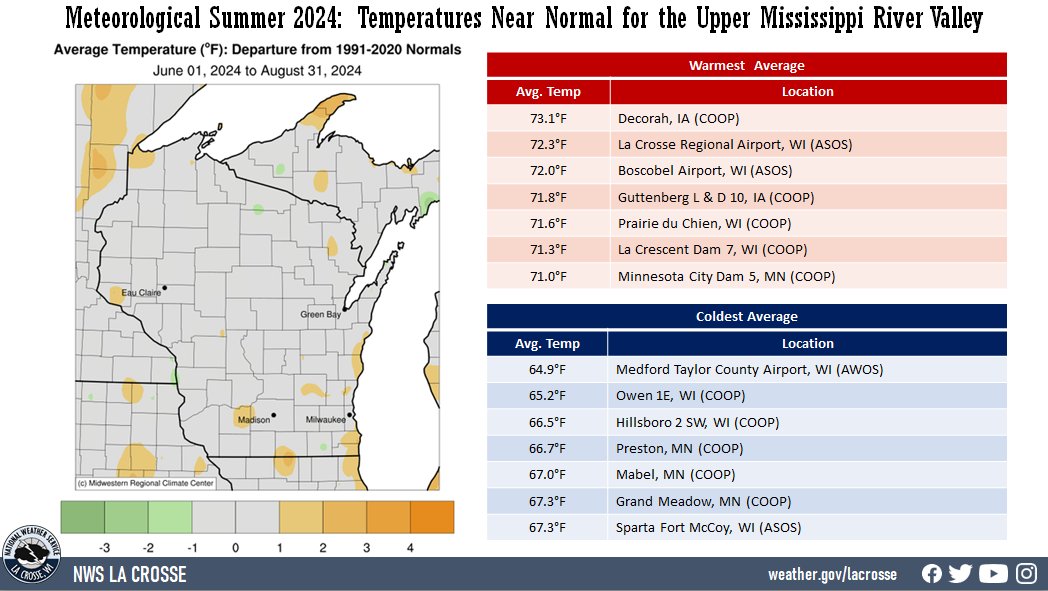
- During meteorological summer (June 1 through August 31) 2024, average temperatures ranged from 64.9°F at Medford Taylor County Airport (AWOS) to 73.1°F at Decorah, IA (COOP).
- Temperature anomalies were within 2°F of normal.
- There was a 62°F difference between the warmest and coldest temperatures in the Upper Mississippi River Valley.
- The warmest temperature was 98°F at Decorah, IA (COOP) on August 27. Meanwhile, the coldest temperature was 36°F at Sparta Fort McCoy, WI (ASOS) on June 11.
|
 |
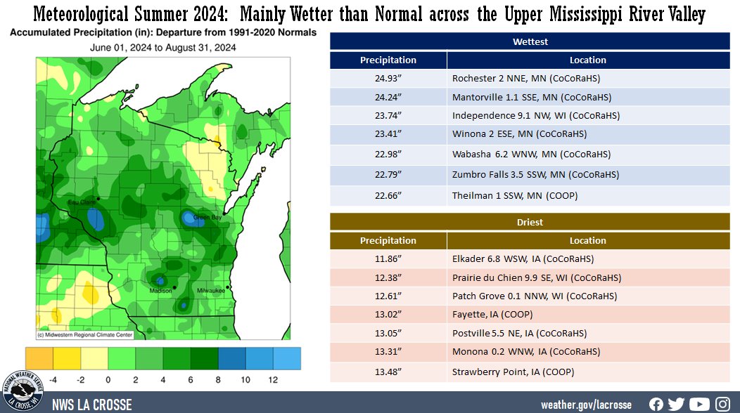
Precipitation - Mainly Wetter than Normal
- Rainfall totals varied from 11.86" near Elkader, IA (CoCoRaHS) to 24.93" near Rochester, MN (CoCoRaHS).
- Rainfall anomalies ranged from 3" drier than normal to 10" wetter than normal.
- The highest one-day precipitation was 5.61" near Wykoff, MN (CoCoRaHS) on June 22. There were unofficial rainfall totals of 6 to 6.5" from southern Winona County (MN) to eastern Jackson County (WI) from August 29-30.
|
 |
Below are the 2024 meteorological summer climate summaries for La Crosse, WI, and Rochester, MN.
La Crosse, WI
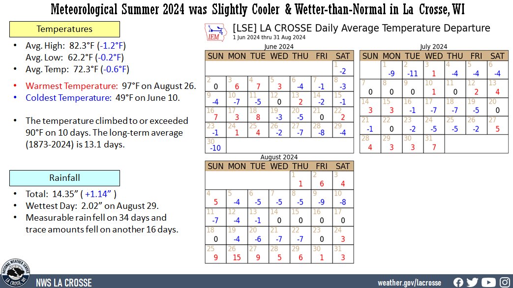
2024 Meteorological Summer was the Slightly Cooler and Wetter than Normal in La Crosse WI
...Meteorological Summer 2024 Highlights...
Temperatures - Slightly Cooler than Normal
- During meteorological summer (June 1st through August 31st) of 2024, La Crosse Regional Airport had an average temperature of 72.3°F.
- This was 0.6°F cooler than the 1991-2020 normal of 72.9°F.
- The table below provides a breakdown of the temperature departures from normal for La Crosse WI this summer.
|
 |
Summer 2024 Temperatures
in La Crosse WI
Departure from
Normal
--------------
June Avg Temp 70.1°F -0.9°F
Avg Max Temp 79.9°F -1.8°F
Avg Min Temp 60.2°F -0.2°F
July Avg Temp 74.0°F -1.0°F
Avg Max Temp 84.2°F -1.2°F
Avg Min Temp 63.8°F -0.7°F
August Avg Temp 72.6°F -0.2°F
Avg Max Temp 82.7°F -0.5°F
Avg Min Temp 62.5°F +0.2°F
Summer Avg Temp 72.2°F -0.7°F
Avg Max Temp 82.3°F -1.2°F
Avg Min Temp 62.2°F -0.2°F
Other temperature tidbits this summer...
- The hottest temperature was 97°F on August 26.
- The coldest high temperature was 68°F on July 2.
- The warmest low temperature was 76°F on August 26.
- The coldest temperature was 49°F on June 10.
- The temperature climbed to or exceeded 90°F on 10 days. The long-term average (1873-2024) is 13.1 days. The greatest number was 41 days in 1988.
- Temperatures averaged above normal on 37 days, below normal on 44 days, and normal on 11 days.
Rainfall - Wetter than Normal
- During the meteorological summer, La Crosse Regional Airport received 14.35 inches of rain. This was 1.14 inches wetter than the 1991-2020 normal of 13.21 inches. The table below contains the monthly rainfall totals and their departures from normal for this summer.
Summer 2024 Rainfall
in La Crosse WI
Departure
Month Rain Total from Normal
----- ---------- -----------
June 5.14 inches +0.06 inches
July 5.42 inches +1.19 inches
August 3.79 inches -0.11 inches
Summer 14.35 inches +1.14 inches
- Other rainfall tidbits this summer...
- The wettest day occurred on August 29 when 2.02 inches of rain fell.
- Measurable rain fell on 34 days (37%) and trace amounts fell on another 17 days (18.5%).
- No Rain - 42 days (45.7%)
- Trace - 17 days (18.5%)
- 0.01-0.09 inches - 12 days (13%)
- 0.10-0.24 inches - 9 days (9.8%)
- 0.25-0.49 inches - 3 days (3.3%)
- 0.50-0.99 inches - 5 days (5.4%)
- 1.00-1.99 inches - 3 days (3.3%)
- 2.00-2.99 inches - 2 days (2.2%)
Sky...
- It was clear on 42 days.
- It was partly cloudy on 36 days.
- It was cloudy on 4 days.
Sea Level Pressure...
- Highest was 30.34 inches on June 30.
- Lowest was 29.49 inches on June 5.
Winds...
- Highest sustained wind was 44 mph from the northeast on July 13.
- Highest wind gust was 65 mph from the northeast on July 13.
Rochester, MN
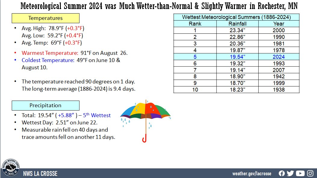
2024 Meteorological Summer Had Its 5th Wettest and It was Slightly Warmer-than-Normal in Rochester MN
...Meteorological Summer 2024 Highlights...
Temperatures - Slightly Warmer than Normal
- During meteorological summer (June 1st through August 31st) of 2024, Rochester International Airport had an average temperature of 69°F.
- This was 0.3°F warmer than the 1991-2020 normal of 68.7°F.
- The table below provides a breakdown of the temperature departures from normal for Rochester MN this summer.
|
 |
Summer 2024 Temperatures
in Rochester MN
Departure from
Normal
--------------
June Avg Temp 67.9°F +0.4°F
Avg Max Temp 77.6°F Normal
Avg Min Temp 58.2°F +0.7°F
July Avg Temp 70.6°F +0.1°F
Avg Max Temp 80.5°F +0.2°F
Avg Min Temp 60.6°F -0.2°F
August Avg Temp 68.5°F +0.3°F
Avg Max Temp 78.4°F +0.4°F
Avg Min Temp 58.6°F +0.3°F
Summer Avg Temp 69.0°F +0.3°F
Avg Max Temp 78.8°F +0.2°F
Avg Min Temp 59.1°F +0.3°F
Other temperature tidbits this summer...
- The hottest temperature was 91°F on August 26.
- The coldest high temperature was 68°F on July 2.
- The warmest low temperature was 71°F on August 26.
- The coldest temperature was 49°F on June 10 and August 10.
- The temperature reached 90 degrees on 1 day. The long-term average (1886-2024) is 9.4 days.
- Temperatures averaged above normal on 48 days, below normal on 38 days, and normal temperatures on 6 days.
Rainfall - 5th Wettest
- During the meteorological summer, Rochester International Airport received 19.54 inches of rain.
- This was 5.88 inches wetter than the 1991-2020 normal of 13.66 inches.
- This was the 5th wettest summer and wettest since 2000 (23.34 inches - wettest).
- Below are the 10 wettest meteorological summers in Rochester, MN.
Wettest Meteorological Summers
in Rochester MN
(1886-2024)
Rank Rainfall Year
---- -------- ----
1 23.34 inches 2000
2 22.86 inches 1990
3 20.36 inches 1981
4 19.87 inches 1978
5 19.54 inches 2024
6 19.32 inches 1993
7 19.14 inches 2007
8 18.90 inches 1942
9 18.70 inches 1999
10 18.23 inches 1938
- The table below contains the monthly rainfall totals and their departures from normal for this summer.
Summer 2024 Rainfall
in Rochester MN
Departure
Month Rain Total from Normal
----- ---------- -----------
June 9.86 inches +4.51 inches - 3rd Wettest
July 4.76 inches +0.57 inches
August 4.92 inches +0.80 inches
Summer 19.54 inches +5.88 inches
Other rainfall tidbits this summer...
- The wettest day occurred on June 22 when 2.51 inches of rain fell.
- Measurable rain fell on 40 days (43.5%) and trace amounts fell on another 11 days (12%).
- No Rain - 41 days (44.6%)
- Trace - 11 days (12%)
- 0.01-0.09 inches - 14 days (15.2%)
- 0.10-0.24 inches - 7 days (7.6%)
- 0.25-0.49 inches - 3 days (3.3%)
- 0.50-0.99 inches - 8 days (8.7%)
- 1.00-1.99 inches - 6 days (6.5%)
- 2.00-2.99 inches - 2 days (2.2%)
Sky...
- It was clear on 50 days.
- It was partly cloudy on 38 days.
- It was cloudy on 4 days.
Sea Level Pressure...
- Highest was 30.36 inches on June 30.
- Lowest was 29.51 inches on June 24.
Winds...
- Highest sustained wind was 63 mph from the northwest on July 13.
- Highest wind gust was 81 mph from the northwest on July 13.


 Weather Story
 Weather Map
 Local Radar