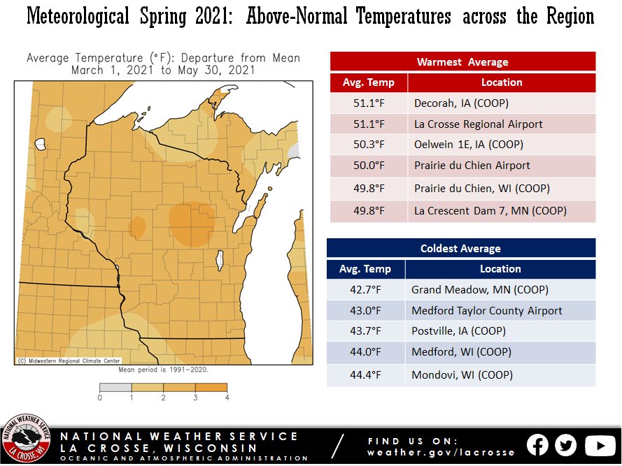
During the 2021 meteorological spring (March 1-May 31), temperatures averaged 1 to 3°F warmer-than-normal across the Upper Mississippi River Valley. Seasonal average temperatures ranged from 42.7°F at Grand Meadow, MN to 51.1°F at Decorah, IA and La Crosse Regional Airport. Normally, spring temperatures average 40°F to 45°F north of Interstate 94 and 45°F to 50°F across the remainder of the area.
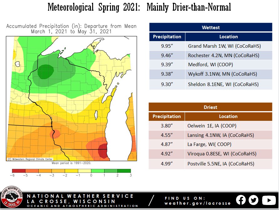
Precipitation totals were up to 1” wetter-than-normal north of Wisconsin 29 in north-central Wisconsin. Elsewhere, precipitation deficits were up to 4”. Precipitation totals ranged from 3.80” near Oelwein, IA to 9.95” in Grand Marsh, WI. Normally, 8 to 11 inches of precipitation falls during meteorological spring. Due to the spring precipitation deficits along with those over the winter, abnormally dry (D0) to moderate (D1) drought conditions developed across the La Crosse Hydrologic Service Area.
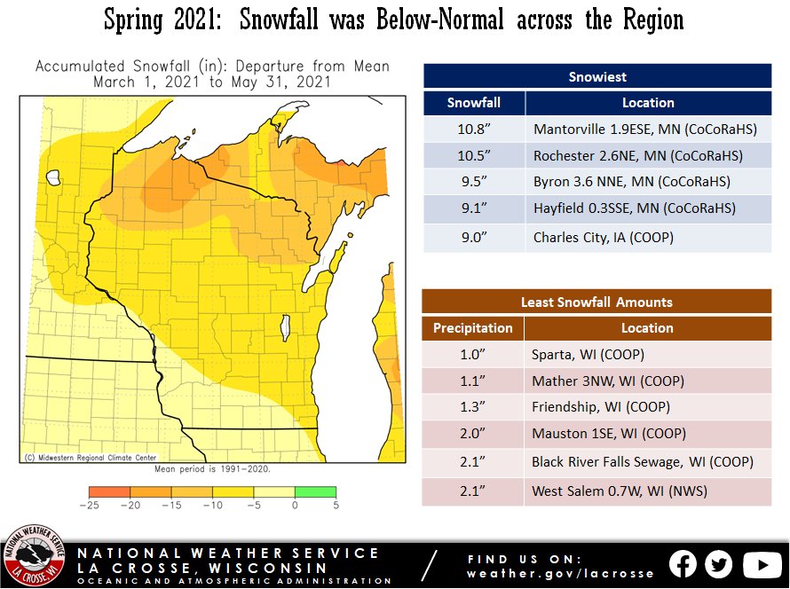
Snowfall was below-normal across the Upper Mississippi River Valley. Snow totals ranged from 1” at Sparta, WI to 10.8” near Mantorville, MN. Normally snowfall ranges from around 5” across the northeast Iowa and southwest Wisconsin to 10” to 15” north of Interstate 94.
 |
 |
 |
| Temperature Anomalies |
Precipitation ​Anomalies |
Snowfall ​Anomalies |
The meteorological spring of 2021 was warmer (2.6F warmer-than-normal) and drier-than-normal (2.55 inches drier-than-normal) at La Crosse Regional Airport. It was the 8th warmest spring. 5 out 11 warmest springs have occurred since 2000. More details on these statistics can be found below.
Temperatures -
From March 1st through May 31st, La Crosse Regional Airport had an average temperature of 51.2F. This was 2.6F warmer than the 1991-2020 normal of 48.6F. The table below contains the monthly temperatures and their departures from normal for the spring of 2021.
Spring 2021 Temperatures
in La Crosse WI+
Average Departure
Month Temperature from Normal
----- ----------- -----------
March 42.2 degrees +7.7 degrees - 7th Warmest
April 50.3 degrees +1.7 degrees
May 60.8 degrees -0.2 degrees
Spring 51.2 degrees +2.6 degrees - 8th Warmest
+ March and April used 1981-2010 normals. May and Spring used 1991-2020 normals.
Precipitation -
From March 1st through May 31st, La Crosse Regional Airport received 7.57 inches of precipitation. This was 2.55 inches drier than the 1991-2020 spring normal of 10.12 inches. The table below contains the monthly precipitation totals and their departures from normal for the spring of 2021.
Spring 2021 Precipitation
in La Crosse WI+
Precipitation Departure
Month Total from Normal
----- ------------- -----------
March 1.51 inches -0.53 inches
April 1.32 inches -2.02 inches
May 4.74 inches +0.41 inches
Spring 7.57 inches -2.55 inches
+ March and April used 1981-2010 normals. May and Spring used 1991-2020 normals.
Snowfall -
From March 1st through May 31st, the snow observer near La Crosse Regional Airport recorded 4.0 inches. This was 6.2 inches less than the 1991-2020 normal of 10.2 inches. The table below contains the monthly snowfall totals and their departures from normal for the spring of 2021.
Spring 2021 Snowfall
in La Crosse WI+
Snowfall Departure
Month Total from Normal
----- ------------- -----------
March 4.0 inches -3.1 inches
April Trace -1.7 inches
May 0.0 inches 0.0 inches
Spring 4.0 inches -6.2 inches
+ March and April used 1981-2010 normals. May and Spring used 1991-2020 normals.
The meteorological spring of 2021 was warmer (2.6F warmer-than-normal) and drier-than-normal (2.10 inches drier-than-normal) at Rochester International Airport. This was the 14th warmest spring. 7 out of the 15 warmest springs have occurred since 2000. More details on these statistics can be found below.
Temperatures -
From March 1st through May 31st, Rochester International Airport had an average temperature of 47.4 degrees. This was 2.6 degrees warmer than the 1991-2020 normal of 44.8 degrees.
The table below contains the monthly temperatures and their departures from normal for the spring of 2021.
Spring 2021 Temperatures
in Rochester MN+
Average Departure
Month Temperature from Normal
----- ----------- -----------
March 38.0 degrees +5.6 degrees - 10th Warmest
April 46.4 degrees -0.3 degrees
May 57.6 degrees 0.0 degrees
Spring 47.4 degrees +2.6 degrees - 14th Warmest
+ March and April used 1981-2010 normals. May and Spring used 1991-2020 normals.
Precipitation -
From March 1st through May 31st, Rochester International Airport received 6.99 inches of precipitation. This was 2.10 inches drier than the 1991-2020 normal of 9.89 inches. The table below contains the monthly precipitation totals and their departures from normal for the spring of 2021.
Spring 2021 Precipitation
in Rochester MN+
Precipitation Departure
Month Total from Normal
----- ------------- -----------
March 2.08 inches +0.20 inches
April 0.81 inches -2.43 inches - 4th Driest
May 4.10 inches -0.25 inches
Spring 6.99 inches -2.10 inches
+ March and April used 1981-2010 normals. May and Spring used 1991-2020 normals.
Snowfall -
From March 1st through May 31st, the snow observer near Rochester International Airport recorded 8.9 inches of snow. This was 3.5 inch less than the 1991-2020 normal of 12.4 inches. The table below contains the monthly snowfall totals and their departures from normal for the spring of 2021.
Spring 2021 Snowfall
in Rochester MN+
Snowfall Departure
Month Total from Normal
----- ------------- -----------
March 8.9 inches +0.2 inches
April Trace -3.3 inches
May 0.0 inches 0.0 inches
Spring 8.9 inches -3.5 inches
+ March and April used 1981-2010 normals. May and Spring used 1991-2020 normals.


 Weather Story
 Weather Map
 Local Radar