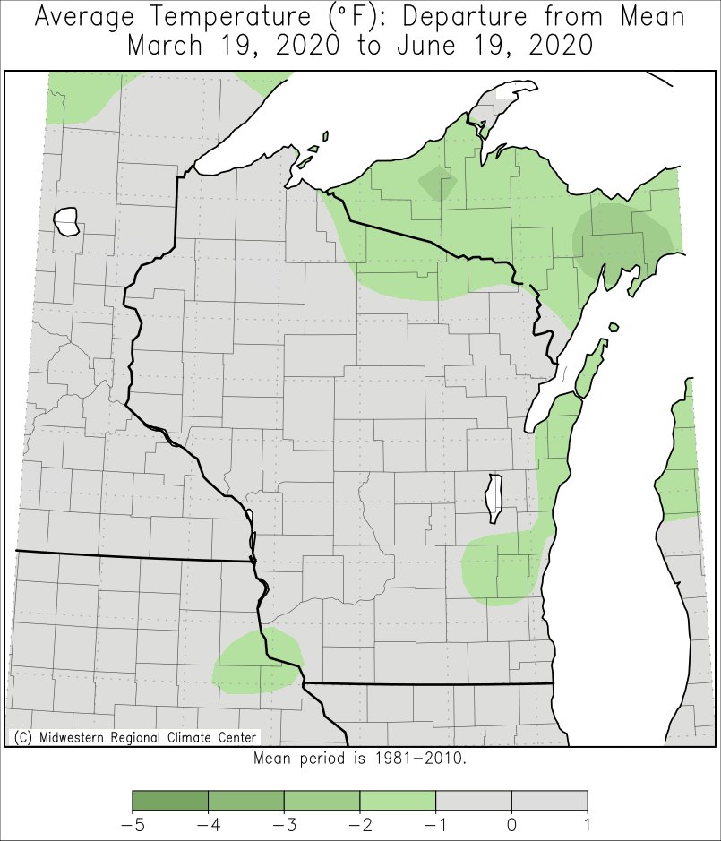
While the astronomical 2020 spring (March 19 to June 19) saw near-average temperatures, temperatures were far from that. There were several periods of well-above and well-below average temperatures. Some areas even saw record cold temperatures in mid-April and record warm temperatures in early June.
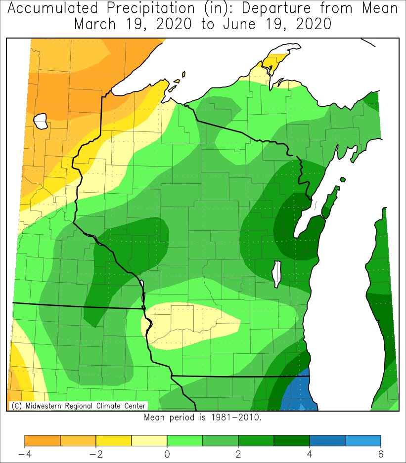
Precipitation was up to an inch drier-than-average in southwest Wisconsin. Meanwhile, the remainder of the area saw precipitation supluses anywhere from 1 to 4 inches above average.
Above average snow fell from southeast Minnesota into north-central Wisconsin. Much of that snow fell on April 12 (Easter Sunday). Elsewhere, snow totals were near- to below-average.
 |
 |
 |
| Temperature Departures | Precipitation Departures | Snowfall Departures |
More details for La Crosse, WI and Rochester, MN can be found below.
During the astronomical spring of 2020, temperatures averaged warmer and wetter than average at La Crosse Regional Airport. More details on these statistics can be found below.
Temperatures -
From March 19 through June 19, La Crosse Regional Airport had an average temperature of 55.6°F. This was 1.1°F warmer than the long-term average of 54.5°F.
There were 3 days in which the high temperature reached or exceeded 90°F.
There were 16 days in which the low temperature was 32°F or colder.
Precipitation -
From March 19 through June 19, La Crosse Regional Airport received 11.23" of precipitation. This was 1.12" wetter than the long-term average of 10.11".
Measurable precipitation (0.01" or greater) fell on 35 days and a trace of precipitation fell on 15 days.
The wettest spring day was 1.91" on June 9.
Snowfall -
From March 19 through June 19, the snow observer near La Crosse Regional Airport measured 3.4" of snow. This was 1.5" less than the long-term average of 4.9".
Measurable snow (0.1" or greater) fell on 5 days and a trace of precipitation fell on 4 days.
The snowiest day was 1.5" on April 12.
Snow Depth -
The greatest snow depth was 2" on April 13.
During the astronomical spring of 2020, it was wetter-than-average with near-average temperatures at Rochester International Airport. More details on these statistics can be found below.
Temperatures -
From March 19 through June 19. Rochester International Airport had an average temperature of 52.2°F. This was 0.1°F warmer than the long-term average of 52.1°F.
There were 2 days in which the high temperature reached or exceeded 90°F.
There were 28 days in which the low temperature was 32°F or colder.
Precipitation -
From March 19 through June 19, Rochester International Airport received 11.77 " of precipitation. This was 1.59" wetter than the long-term average of 10.18".
Measurable precipitation (0.01" or greater) fell on 42 days and a trace of precipitation fell on 10 days.
The wettest spring day was 2.20" on May 17.
Snowfall -
From March 19 through June 19, the snow observer near Rochester International Airport measured 10.3" of snow. This was 4.6" snowier than the long-term average of 5.7".
Measurable snow (0.1" or greater) fell on 10 days and a trace of precipitation fell on 2 days.
The snowiest day was 7.5" on April 12.
Snow Depth -
The greatest snow depth was 8" on April 13.

