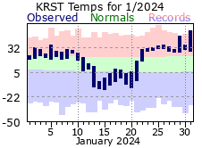
A dry and mild start to 2024 with nary a snowflake and above normal temperatures through the 6th of January for Rochester. A spate of days with mostly light snowfall changed the narrative starting with a few flurries on the 7th followed by measurable snows (albeit relatively minor amounts) for the 8th through the 13th. Much colder air flowed in on the tail end of these snows with temps dropping below normal for the 12th through the 21st. Temperatures would then turn back to the mild conditions experience during the first week, although markedly warmer this go around. The average temperatures from the 22nd through the 31st was 32.6 degrees, the 2nd warmest on record (for that period of January). Highs cracked the 50-degree mark on the 31st (52 degrees), 9th earliest 50 degree day in a year on record for Rochester (average is March 10th). As for additional precipitation, there wasn’t much after the 13th with only and 0.06” and 0.3” of snow. Overall, while there were 7 days with measurable snow (average for a January), most were around 2” or less, and the monthly total of 7.6” was around 4 ½” under a typical January.
|
 |
| |
|
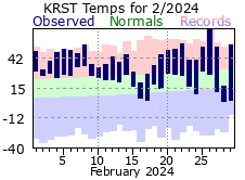
The very mild conditions would continue for February with only one day of below normal temperatures. There were 10 days with temperatures at or above 50 degrees, well above the average of 1 and an all-time record for February. The 69 degree high on the 26th was the 4th earliest 60-degree temperature in a year for Rochester. In addition, there were only 4 days where temperatures chilled into the single digits or lower (tying it for 6th least in a February) while not once chilling below zero (average is 8 days). Conversely, lows were recorded at 20 degrees or warmer on 19 days – 4th most in a February and above the average of 7. A mild February by any measure and the 32.6 average temp made it the all-time warmest February on record for Rochester. As for precipitation, it was a very dry month. Measurable precipitation fell on only 4 days (average is 7) for a total of only 0.34 inches (around 2/3rds of an inch below normal). With the mild conditions, most of that fell as rain. There were only 3 days of measurable snowfall with the 2.0” monthly total making it the 10th least snowy February on record for Rochester.
Checking in on the 3 winter months of December 2023 through February or 2024, the average temperature was 27.9 degrees – making it the all-time warmest on record.
|
 |
| |
|
|
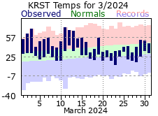
The mild conditions continued moving through the first half of March with above normal temperatures recorded through the first 16 days. This stretch was the warmest of its kind for Rochester. Temperatures reached or exceed 70 degrees twice during this period. The 72-degree high on the 3rd is the earliest 70 degree or warmer temperature in a year for Rochester. Temps took a downturn starting the 17th with mostly below normal readings through month’s end. The month’s average temperature would still finish well above normal (+5.6 degrees) despite the stark differences between the first and second halves but just outside the top 10 for record warmth (11th warmest). It was a dry start to February with only 3 days of measurable precipitation amounting to less than 1/10". Only a few flurries for snow. Measurable precipitation then fell on 6 consecutive days (21st through 26th) with 8.6” coming as snow.
|
 |
| |
|
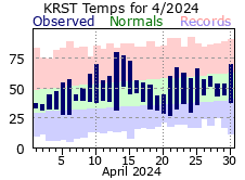
While not as warm compared to the respective monthly norms ala the previous 3 months, April continued the mild trend finishing over 1 ½ degrees above normal. More fluctuations in day to day temps but highlighted by a warm stretch during mid month. The high reached 80 degrees on the 13th for the first time in 2024, about 3 weeks ahead of the average. Measurable precipitation dropped on 14 days with 10 of those recording 1/10” or more, tied for 4th most in an April. The last snows of the 2023-24 season would fall over the 1st through 3rd for a total of 3.5”.
Looking back at the 2023-24 snowfall season, only 24.0” fell – making it the 4th least snowy season on record for Rochester.
|
 |
| |
|
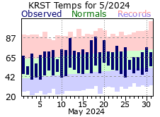
Aside from a smattering of a few warmer days, daily temperatures generally hovered plus/minus 5 degrees around the daily normals. While highs climbed above 85 degrees twice, they also failed to warm above 60 twice. Still, most days warmed above the monthly normal and, on the whole, April rounded out close to 2 degrees above normal as a result. The April rainfall total was right on its normal but dominated by a few wet days. Of the 13 days with measurable rain 7 of those recorded less than 1/10”.
Looking at the spring months (March-April-May), the average temperature was a mild 47.9 degrees – tied for 8th warmest on record
|
 |
| |
|
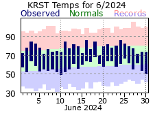
Much like May, June didn’t experience any significant or prolonged swings in day-to-day temperatures, more or less fluctuating within 5 degrees of the normal. Highs never reached 90 but never dipped into the 60s either. The average for the month was just a hair above normal. The same could not be said for rainfall as Rochester experienced a month-long deluge of wetness. There were 19 days with measurable rain, well above the average of 11 and 2nd most in a June. Of those, 8 recorded ½” or more – tying for 1st all-time with 1914. The longest break between measurable rains was only 2 days while mid month saw a stretch of 8 straight days where rain at least dampened the ground (15th through the 22nd). This tied it for 8th longest such streak on record for Rochester. Unsurprisingly, all the rainfall culminated in the 3rd most in any June for Rochester (9.86”) and the 9th most of any month all-time.
|
 |
| |
|
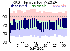
July followed the lead of April and June when it came to temperatures – not swinging too far off the daily normal and finishing right around its monthly normal for average temperature. The sogginess of June would spill over into the first half of July with 8 out of the first 15 days recording measurable rainfall. However, that stretch would account for 95% of the monthly total as there would only be 2 other days with measurable rain after that. Diving into this further, the first 15 days of July were the 5th wettest on record for Rochester (4.52”) while the last 16 days were the 13th driest with only 0.24” falling. Soggy start, dry end.
|
 |
| |
|
|
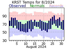
As had been the case the previous 3 months, there were not any significant swings in temperature or prolonged periods of hot or cool conditions for August. The first 90-degree day of 2024 did occur on the 26th (91). Rainfall for the month was fairly average when it came to days with measurable rains (had 11, the average is 10), but 3 of those recorded over 1” - which amounted to more than 75% of what would fall for August. There were also 8 and 9 day stretches where only a trace of rain fell. So, while the monthly precipitation total paints one picture, daily rainfall amounts paint a different one.
Looking at the summer months (June-July-August) 19.54 inches or rain fell, 5th most for a summer in Rochester.
|
 |
| |
|
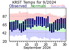
September traditionally marks the start of fall, but this year it felt more like a continuation of summer. The first week was a bit cool with every day but one averaging below normal. Milder to warm air settled in after that with the month on the whole averaging 65.4, over 4 degrees above normal and also marking it as the 5th warmest September on record for Rochester. There were 14 days with 80 degree or warmer temperatures, tying it for 5th most in a September (average is only 7 days). September was a very dry month. There were only 4 days with measurable rainfall, tying it with many other years for 2nd least in a September. Nearly 94% of the monthly total fell on one day – with 0.72” on the 19th. The grand total of just 0.77” made it the 8th driest on record for Rochester.
|
 |
| |
|
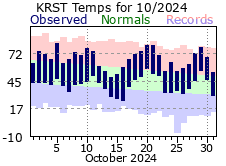
October experienced up’s and down’s for temps for the first 2 weeks, oscillating between a bit above or a bit below average. Thermostats turned up for the second half of the month, however, with temps from the 17th through month’s end averaging around 11 ½ degrees above normal. This late month warm up averaged 55.7 degrees and made it the 2nd warmest of its kind for an October. 3 days reached or topped 80 degrees. The last 80 degree day for 2024 fell on the 21st, tied for 4th latest occurrence in a year for Rochester (average is Sep 29th). Overall, the month finished at 54.5 degrees for an average, over 6 ½ degrees above normal and 5th warmest on record. October was another very dry month. Like September, there were only 4 days with measurable precipitation. The bulk of what fell occurred on the last 2 days, accounting for nearly 75% of the 1.13” monthly total. In fact, there was only 1 day where 0.01” fell over the first 23 days of the month. Going back to September, that would mark 34 days with only 0.01” – essentially a month with no rain.
|
 |
| |
|
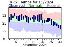
November continued the mild fall trend but it wasn’t excessively warm despite averaging over 3 ½ degrees above normal. Most days were within 5 to 10 degrees of the daily normal. Colder air moved in for the end of the month. Highs didn’t warm out of the teens, nor did lows climb out of the single digits, on the 29th and 30th. Precipitation was above normal and spread out through the month. A welcome break from the very dry conditions of September and October. The first measurable snow of the 2024-25 winter season dropped on the 20th with 0.2”, about 2 weeks later than the average (Nov 4th).
The fall months of September through November averaged 52.4 degrees, making it the 4th warmest fall on record in Rochester, There were 25 days where temps reached or exceeded 80 degrees, 2nd most for the fall, as was the 40 days with 70 degrees or warmer.
|
 |
| |
|
|
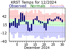
December finished off the year on a mild note, making it 12 for 12 for months with above normal temperatures in 2024 in Rochester. There were some “ups and downs” when it came to temperatures though, with a colder start and a mild finish to the month. Highs in the 50s on the 7th and 8th were followed by below zero lows on the 11th and 13th. Precipitation was normal for a typical December but highlighted by 2 events. First, over 6” of snow fell over the 19th and 20th, with snow cover lasting through the Christmas holiday. This would be the bulk of December’s snowfall, however, with only 4 other days recording measurable snow – and those amounted to less than 1”. The other event was over ¾” of rain that fell on the 27th and 28th. Not only did this rain help melt the remaining snow cover away, but it also served to saturate the atmosphere such that several days of widespread fog settled across Rochester.
|
 |
| |
|
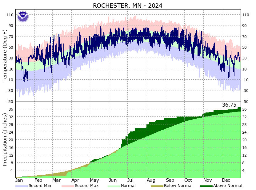
2024 for Rochester would be marked as one of its warmest years on record as the 48.6 degree average made it the 3rd warmest. Interestingly, the warmth had little to do with any hot stretches during the summer months, rather it was more about very mild periods during the winter and fall months. For instance, there was only 1 day where temperatures climbed into the 90s in 2024. In an average year this occurs 10 times. However, there were 245 days where highs reached or exceeded 50 degrees - this set an all-time record of such days in Rochester and was well above the average of 211. Further, there were only 143 days where freezing temperatures were realized. This is the 8th least amount of such days in a year for Rochester which, on average, has 162 freezing days.
Precipitation for 2024 was around 2” above normal. For the year, there were 115 days with measurable precipitation – right around the average of 112. However, 30 of those days recorded ½” or more, tying it for 3rd most in a year (average is 19 days). Despite finishing above normal, there was a notable dry period: from September 20th through October 23rd only 0.01” of rain fell – essentially over a month with no rain.
|
 |