|
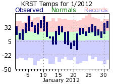
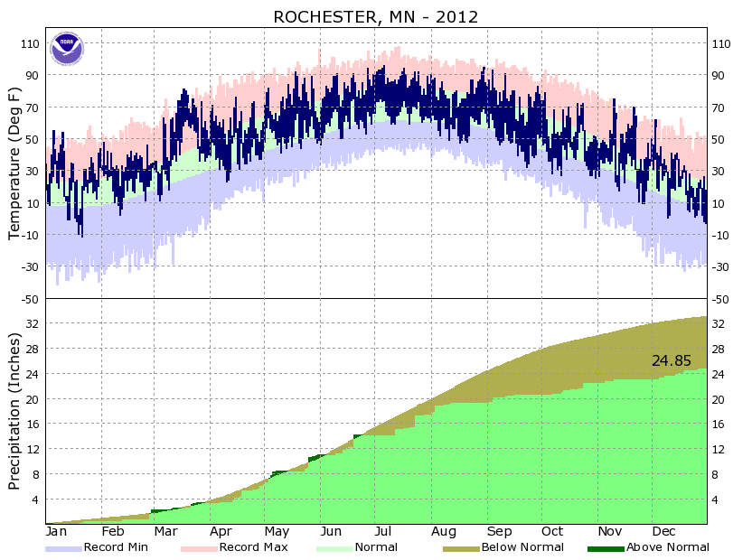
2012 got off to a warm start with January finishing over 7 degrees above the monthly normal. Temperatures did jump around though, with highs in the 40s and 50s 9 times, and in the single digits to teens 4 times. Lows only dropped below zero 6 times though, well below the average of 13 days. Meanwhile, precipitation was close to the January normal. Measurable snow fell on10 days, but 8 of those recorded less than 1 inch.
|
 |
| |
|
|
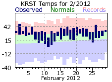
The warmth continued in February with temperatures never falling below zero and only two days with below normal temperatures. In an average February, morning lows drop below zero on 8 days. Although precipitation finished above normal, it was a dry month until the last two days. Less than 1/3 inch of precipitation fell through the 27th. On the 28th and 29th, however, 1.34 inches of rain dropped on Rochester – 82 percent of the monthly total. There were 8 days with measurable snow, but like January, when it did fall amounts were small. Six of those days recorded ½ inch or less with a one-day high of only 1.8 on the 13th.
|
 |
| |
|
|
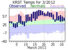
Mother Nature turned up the heat even more in March. Average temperatures finished a whopping 16.7 degrees above normal, easily crushing the previous warmest March on record. The 49.1 monthly average was more than 6 degrees above the 1910 record of 42.9. The month did start out cool though with highs in the 20s and 30s for the first 5 days. It quickly warmed after that with the warmest part of a month coming on a 6-day stretch from 14th through the 19th. Highs topped 70 everyday, reaching 80 or better on the 17th and 18th. Lows during this stretch were above the normal highs. 18 daily temperature records for highs and warmest lows were set or tied in March. The warmth was welcomed by many, eager to leave the colder winter months behind. Plants also responded with early blooms on flowers and many trees budding out. Unfortunately, a lot of this vegetation would be damaged or killed in April when freezing temperatures returned. There were 10 days with measurable precipitation, but amounts were generally small (6 days under 1/10 of an inch). With all the warmth, snow was almost non-existent. There were 4 days with a trace of snow, all in the first 8 days. This trace tied with it several other years for the 2nd least snowy March on record for Rochester.
|
 |
| |
|
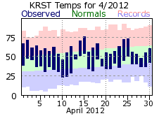
April brought a dose of normalcy to Rochester as temperatures tumbled downward to more seasonable spring values. While April did finish above normal, below normal temperatures were recorded on half the days. Freezing temperatures occurred 6 times, with a chilly 23 on the morning of the 10th. The cold temperatures damaged and killed some vegetation that blossomed and budded early due to the exceedingly warm March. Highs couldn’t even break 50 as late as the 28th (48 degrees). Precipitation was ½ inch below normal for a typical April and started out quite dry (0.05 inches falling through the 12th). The bulk of the monthly precipitation fell over the next 7 days (1.87” for 70% of the total). The last snowfall of the 2011-12 season came on the 16th when a few flurries flew.
|
 |
| |
|
|
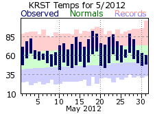
May continued 2012’s warm trend, finishing over 5 degrees above normal. Temperatures bounced around quite a bit though, typical for a spring month transitioning from a winter to summer pattern. High temperatures were 80 or greater 9 times, topping 90 on the 18th. However, temperatures also failed to warm above 70 11 times, with a rather chilly 60 on the 31st (coldest high of the month). April finished about 1 ¼ inches above normal for precipitation, most of it falling at the start and end of the month. From the 9th through 23rd only 0.05 inches of rainfall was recorded. The strongest wind of 2012 was felt in May as thunderstorms on the 26th gusted winds to 69 mph.
On the strength of a historically warm March, the spring months averaged 53.8 degrees, making it the warmest spring on record for Rochester (easily beating the previous record of 52.1 degrees set in 1977).
|
 |
| |
|
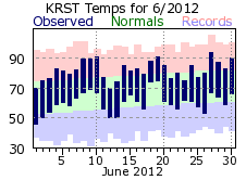
The summer month’s started fairly cool with highs in the 70s and lows in the mid 40s to low 50 for the 1st through 3rd of June. Temperatures warmed after that, reaching 90 or greater 4 times – above the typical June average of 1 to 2. That said, June had its handful of cooler days, with highs in the 70s 11 times. Rainfall was about 1 ½ inches below normal with most of the month’s total falling at mid-month. The bulk of the rain came on one day, the 20th, with 1.94 inches amounting for 60 percent of June’s total. After the 20th, only a trace of rain fell. In fact, this stretch of dry days would persist through July 12th – a span of 21 days with only a trace of rain.
|
 |
| |
|
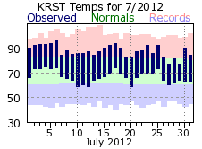
The oven was switched to “high” and was stuck there for much of July. The 77.1 average made it the 4th warmest July on record for Rochester, along with the 4th warmest month all-time. Highs were 90 degrees or greater a whopping 11 times – well above the normal of 3 to 4 days for a July and easily eclipsing the yearly average of 7. Heat Advisories and Excessive Heat Warnings were in effect for most of the region from the 2nd through the 6th. Tragically, the extreme heat of July resulted in the loss of life. Five residents of western and central Wisconsin perished from heat related causes. The causes for the prolonged heat, mostly a strong upper level ridge, also resulted in a dry weather pattern for the region. Measurable precipitation only occurred on 7 days in July at Rochester, with 5 of those days recording less than ¼ of an inch. The other two days accounted for 75% of the monthly total (0.96 on the 13th and 1.80 on the 24th).
|
 |
| |
|
|
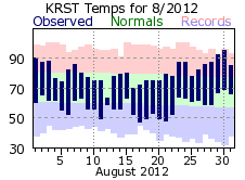
August brought some relief from the heat with temperatures right around the seasonable normals. Highs did reach 90 or greater 3 times, but were also in the 70s 15 times, with a cool 63 degrees on the 12th. Temperatures were below normal on 16 out of 19 days from the 4th through 22nd. Additional relief via rain did not occur, however. Measurable rain did fall on 12 days, but like July, 8 of those days were well under ¼ of an inch. The August total of 1.96 inches was over 2 ½ inches below normal with the first 2 weeks accounting for 96% of this amount. Only 0.05 inches of rain fell after the 13th.
The hot June and July helped the summer months round out as the 2rd warmest on record for Rochester (72.4 degrees). While the lack of rainfall did not set any records, the persistent dry conditions impacted crops and exacerbated a drought that been on going. The early warm-up and then freeze, along with the lack of summer rain, made for a very poor growing season for many.
|
 |
| |
|
|
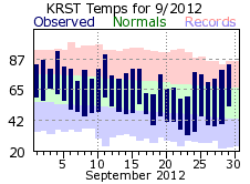
Temperatures bounced around quite a bit in September and the month wound up finishing about a degree above normal. There were 2 days that warmed to 90 degrees or greater, but there were 2 days that couldn’t warm above 60. The first freeze of the fall season came on the 23rd when temperatures dropped to 32 degrees. This was a week ahead of the usual first fall freeze for Rochester – September 30th. Unfortunately, rain continued to a rare commodity. The 1.29 inch total was over 2 inches below normal. What did fall came during the first part of the month. From the 18th through the 30th only 0.02 inches were recorded.
|
 |
| |
|
|
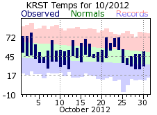
October was seasonable in terms of its average temperature, rounding out right around the monthly normal. However, there was quite a bit of fluctuation in daily temperatures. There were almost as many days with highs in the 70s (7) as there were in the 40s (6). Low temperatures dropped to freezing or lower 8 times. Precipitation was a bit below normal. There were 12 days with measurable precipitation, above the 8 to 9 day average of a typical October. However, nearly 50% of the month’s total fell on the 25th (0.84 inches), while 7 of the other rainy days recorded around 1/10 of an inch or less.
|
 |
| |
|
|
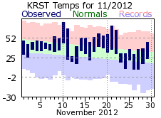
After a few months of near normal temperatures, November returned the early warm ways of 2012, finishing around 4 ½ degrees above normal. There were 4 days when highs topped 60, with 2 of those warming to 70 or greater. However, there were also 4 days when temperatures never warmed above freezing. The 11th and 12th of the month had the most dramatic swing as a cold front swept across the region. It warmed to 66 degrees on the 11th, but could only top out at 27 on the 12th. In addition, that front brought around ¼ inch of rainfall to Rochester on the 11th, and the only measurable snowfall for November on the 12th (0.1”). This was well below the normal of around 7 inches. There were only 4 days with measurable precipitation, with the 6th and 11th accounting for 94% of the monthly total. There was no measurable precipitation after the 12th.
|
 |
| |
|
|
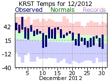
December started off quite warm, with above normal temperatures on 18 out of the first 20 days. The warmest day was the 3rd with a high of 62, 12 degrees warmer than any other December day. Temperatures cooled for the last third of the month, at or below the monthly normals. Precipitation was above normal while the 14.4 inch snow total was a couple inches above an average December. In fact, the 14.4 inch amount was 70% of the entire 2011-12 winter season total in Rochester. Two winter storms accounted for a bulk of the snow with 4.1 inches on 9th and another 5.5 on the 20th. The 20th saw near blizzard conditions at Rochester with winds gusting to 47 mph while averaging 24 mph through the day.
|
 |
| |
|
|
2012 will be remembered as the warmest on record for Rochester. March crushed its previous warmest on record by over 6 degrees, setting 18 daily high temperature records. On the whole, 33 daily records were set or tied for warmth, with the no cold records. July baked the region and was the 4th warmest month on record for Rochester. Amazingly, 7 months in 2012 set top 10 records for warmth with 2/3rds of the days recording above normal temperatures. Weather had a big impact on the crops. The very dry conditions exacerbated an ongoing drought, negatively impacting plant growth and harvest. Meanwhile, the early warm up in March followed by an April freeze damaged many fruit trees in the region.
|
 |