|
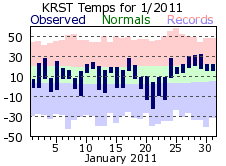
January 2011 was about average when it came to temperatures, but was marked by two distinct cold and warm periods, but in the latter half of the month. A blast of cold air moved into Rochester on the 19th, hanging around through the 23rd. Highs were in single digits for all but one day, while lows were below zero. This 5 day stretch was over 13 degrees below normal and harbored the coldest day of 2011: -22 on the 21st. There was a quick warm up right after this frigid period with lows popping back into the teens and highs mostly in the 20s to around 30. Snowfall was spread out across the month with measurable amounts on 12 days. Much of the snowfall was minimal though, with 7 of those days recording less than an inch. The highest amount was only 2.8 inches on the 31st.
|
 |
| |
|
|
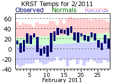
Like January, February was right around its monthly normal for temperature, but had distinct cold and warm periods. Cold air moved in for the second week of February, with temperatures around 20 degrees below normal for the 8th through the 10th. Highs did not climb above zero on the 8th. Milder air returned for the 13th through 17th as highs warmed to around 40 degrees and lows hovered around 30. February got off to a dry start with only 1.1 inches of snow falling over the first 19 days. Rochester managed to avoid a significant snow storm that barreled across Iowa, Illinois and southeast Wisconsin on the 1st and 2nd. A wide band of well over a foot of snow blanketed these areas while only two-tenths of an inch fell in Rochester. The area was not as lucky later on in the month as another storm system took aim on the region. This storm struck the area on the 20th and 21st, bringing a wintery mix of snow, sleet, freezing rain and rain to the region. In Rochester, temperatures were cold enough for snow to be the dominate precipitation type with 7 inches falling over the two-day span. Some freezing rain and sleet did mix in late afternoon on the 20th.
|
 |
| |
|
|
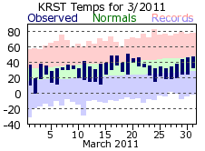
March temperatures continued the early year trend of being close, but just below normal, with no large fluctuations between mild and cold periods. Precipitation was above normal in March, mostly thanks to the 2.20 inches that fell on the 22nd. The first rumbles of thunder for the new year occurred on the 20th, with a few more on the 22nd. There were only 4 days of measurable snowfall with the 4.6 inch monthly total below normal. The windiest day of 2011 came on the 12th of March with average wind speeds of 24.4 mph and a peak gust of 53 mph. This would not be the highest peak gust speed though; that would come a few months later (58 mph on July 1st).
|
 |
| |
|
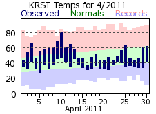
Spring temperatures were hard to come by in April despite finishing above normal. Normally a volatile month for temperatures as the jet stream transitions from the winter to summer season, this April only gave a brief glimpse of summer. The 81 degree day on 10th was the warmest day by far in April; the next warmest was only 69. Highs were in the 40s 13 times and in the 50s 6 times. It never made it to 40 on the 16th with a high of only 38 degrees. A late season winter storm dropped 4 inches of heavy, wet snow on Rochester on the 19th and 20th. Overall, it was a wet month with measurable precipitation on 16 days, with over 1/10 of an inch being recorded on 9 of those.
It was a long winter for Rochester with a record 41.3 inches of snow falling in December and snowfall then continuing to fall into the middle of April. The total for the 2010-11 season was 70.5 inches, well above the 51.9 inch normal and 6th snowiest winter all-time for Rochester.
|
 |
| |
|
|
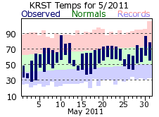
May was above normal on the whole with respect to temperature, but like April, displayed a lot of variance in day to day values. All the seasons were represented with a winter-like high of 39 on the 2nd to summer warmth of 88 on the 10th and 87 on the 30th. The last freeze of the spring was on 4th, a few days earlier than normal. Precipitation was close to normal for a typical May with 7 day recording at least 4 tenths of an inch. The 20th through 25th was a wet stretch as 5 out of the 6 days received nearly ½ inch of rain.
|
 |
| |
|
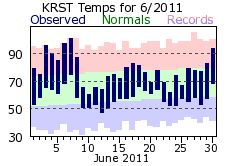
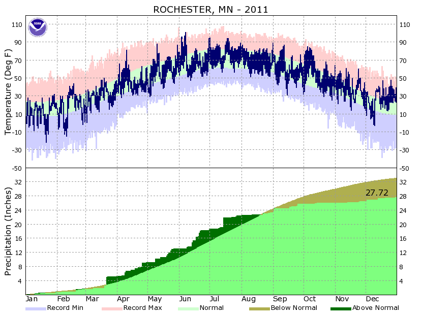
June got off to a blistering start as temperatures reached 90 or greater 4 times in the first week, with the hottest temperature of the year of 101 on the 7th. It was only the 20th time Rochester has hit a temperature of 101 or greater. Despite averaging over 13 degrees above normal in the first week, June temperatures came in just under 2 degrees above normal. This was thanks to some swings that are more typical of spring rather than summer. After the hot 7th highs quickly cooled to 65 by the 9th, dropping a few more degrees to 60 on the 10th. In all, there were 5 days where highs reached or exceeded 90 degrees, but 8 days where it did not top 70. For precipitation, June made it 5 months in a row with above normal precipitation. The rain came in chunks with 5 days of over ½ inch; two of those over an inch.
It was a soggy start to the year. The total of 18.27 inches through the end of June was the 12th wettest first half of a year on record for Rochester. The second half would be a completely different story.
|
 |
| |
|
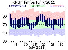
Summer would baste the region in heat during the month of July. Temperatures topped 90 degrees 5 times, with the brunt of heat coming on the 17th through 20th. The average temperature of 75.1 degrees was the 6th warmest on record. Heat advisories and warnings were in effect at various times to account for the dangerous heat. There was a brief 4 day break from the month long heat wave with a string of highs in the 70s from the 12th through 15th. Rainfall was close to the monthly normal, but 65% of that came on the 15th with 2.73 inches. A point of interest here is that after such a wet start to the year, this one day total would be more than any other month, on the whole, would receive for the rest of the year.
|
 |
| |
|
|
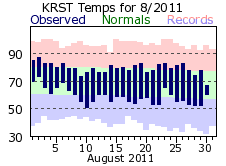
August was right on its monthly normal with respect to temperatures with no significant hot or cold periods. Precipitation, however, was down compared to the previous summer months and a typical August. While there were 8 days with measurable precipitation, less than ¼ inch fell most of the days. The 0.96 total made it the 6th driest July on record for Rochester.
On the whole, the summer of 2011 was a very warm one. The average temperature of 70.8 degrees was the 10th warmest on record for Rochester.
|
 |
| |
|
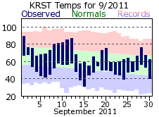
| September kicked off the transition to fall with a warm 89 degree day on the first. This would be the exception though as highs only reached 80 degrees or better 5 more times. After a high of 87 on the 12th, temperatures would be below normal on 13 of the remaining 18 days. Temperatures wouldn’t crack 60 degrees on 6 days. Precipitation was about an inch below the September normal with the stretch of dry days from the 4th through 16th accounting for most of this deficit. Out of the 9 days there was measurable rainfall, 4 of those recorded 1/4 of an inch or greater. |
 |
| |
|
|
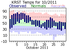
Like 2010, the first half of October 2011 was very mild. Temperatures were above normal from the 2nd through the 16th with highs reaching 80 or greater from the 3rd through 9th. The second half would be cooler, but close to normal. The first freezing temp of the fall came on the 1st, which was just a day later than normal. Overall, the 53.0 degree average made it the 10th warmest October on record in Rochester. October would continue the dry trend, finishing around 2 inches below normal. There was a trace or less of rainfall on 26 of the 31 days. The highest one-day total was only 0.14 inches on the 13th. The monthly total of 0.29 inches made it the 6th driest October on record. The first snowflakes of the season flew on 27th.
|
 |
| |
|
|
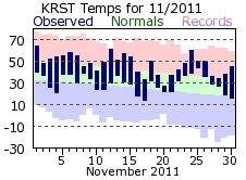
November brought more mild temperatures, rounding out around 4 ½ degrees above its normal. The 38.5 degree average made it the 7th warmest November on record. The warmest period was at the end of the month with the last 9 days averaging over 10 degrees above normal. In fact, low temperatures on the 23rd through 26th were at or above the normal highs for late November. The very dry fall conditions also persisted with measurable rainfall on only 5 days. The 0.38 total was the 16 driest November in Rochester. The first measurable snow of the season fell on the 19th with 0.2 inches. However, this was all that fell and was well short of 6.1 inch November normal.
It was a mild and very dry fall. The meager 3.14 inch precipitation total over the 3 months marked it as the 10th driest on record. The mild 50.3 degree average temperature placed it at 6 for warmest falls in Rochester.
|
 |
| |
|
|
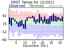
December started out on the cool-side, with below normal temperatures on 7 out of the first 10 days. However, mild air would move in after that and hold across the area for the rest of the month. Highs reached or exceeded 40 degrees 6 times, while low temperatures for the last week of December were closer to the average highs rather than lows. Rochester received only 2/3rds of its normal snowfall for December, the snowiest month on average. There were 9 days with measurable snow, but 5 of those recorded less than ½ inch. A storm system toward the end of month brought a mixed bag of snow, rain, freezing rain and sleet to Rochester on the 30th.
|
 |
| |
|
|
2011 will be remembered as a tale of two halves: one exceeding wet, the other very dry. While Rochester finished over 5 inches below normal for precipitation, it didn’t start out like that. Through July 22.45 inches of precipitation had fallen, well on the way toward the normal value of 33.02. However, Mother Nature’s faucet slammed shut for the rest of the year as only an additional 5 plus inches would fall. The first 7 months of the year would account for 81% of 2011’s total, while the last 5 months were a collective 8 inches below normal. Temperatures also did a flip of their own as the first 3 months were below normal and the last 3 very mild. In the middle was some recording setting heat in June and July.
|
 |
