A stretch of very cold temperatures is expected from tonight through Tuesday. Limit your time outdoors during this timeframe and be prepared for cold weather impacts to vehicles and buildings. Read More >
La Crosse, WI
Weather Forecast Office
Summary
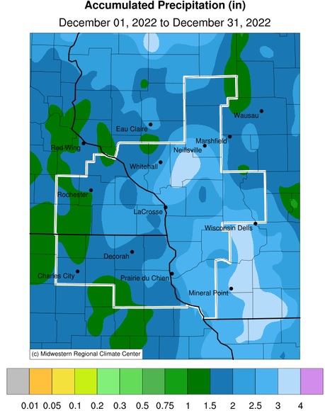
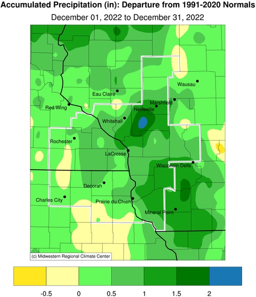
December 2022 precipitation anomalies ranged from near-normal to 2.5” wetter-than-normal across the Upper Mississippi River Valley. Precipitation totals ranged from 1.01” at Grand Meadow, MN (COOP) to 4.01” at Black River Falls, WI (COOP). The greatest 1-day precipitation was 2.31" at Black River Falls, WI (COOP). This precipitation fell from 7 AM on December 14 to 7 AM on December 15.
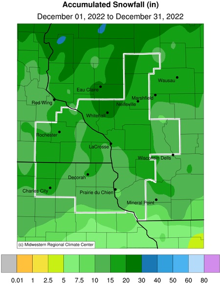
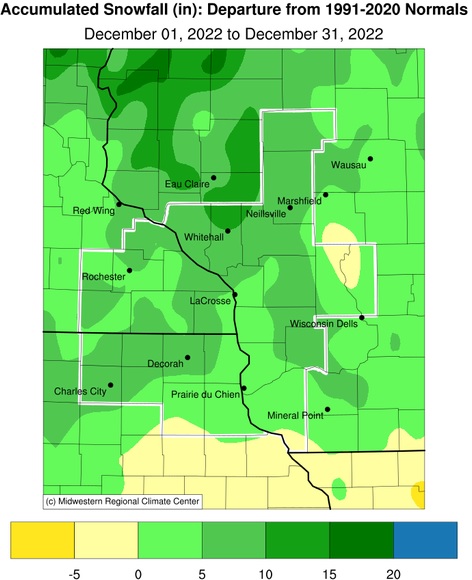
Snowfall was up to 10” above-normal for the month. Snowfall ranged from 7.3” near Oelwein, IA (COOP) to 21.1” at La Farge, WI (COOP). The greatest 1-day snowfall was 6" near Decorah, IA (COOP). This snow fell from 7 AM on December 8 to 7 AM on December 9.
Flood Conditions
During December 2022, there was no river flooding in the La Crosse Hydrologic Service Area (HSA).
River Conditions
USGS average monthly stream flows for December 2022 were above normal for the Lemonweir River at New Lisbon, WI. Elsewhere, the monthly stream flows were either near normal or not ranked in the NWS La Crosse Hydrologic Service Area (HSA).
The Mississippi River at La Crosse, WI had an average 7 AM stage of 5.15 feet during the month. This was 0.09 feet below the 1937-2022 long-term average of 5.24 feet. The lowest stage was 4.76 feet on December 8 and December 9, and the highest stage was 5.79 feet on December 19. This site has not been at or above flood stage (12 feet) since April 12, 2020. This ongoing stretch of 993 days is the 11th longest without reaching the flood stage. It is the longest since a 1,108-day stretch from April 22, 2011, to May 3, 2014 (the 9th longest stretch). The longest stretch was a 3,986-day stretch from May 12, 1954, to April 9, 1965.
Drought
During December 2022, the severe (D2) drought continued over northwest Buffalo County in west-central Wisconsin at 0.1% of the La Crosse Hydrologic Service Area (HSA). Moderate (D1) drought was reduced from 20.1% of the La Crosse HSA at the beginning of the month to 16.3% by the end of the month. Abnormally dry (D0) conditions expanded from 40.7% of the La Crosse HSA at the beginning of the month to 45.4% by the end of the month.
| Precipitation | ||
 |
 |
|
| Snowfall | ||
 |
 |
Our Office
Staff
Want a tour?
Looking for a speaker?
Community Involvement
Station / Location Info
Follow Us On Social Media
Student Opportunities
Weather Safety
SkyWarn
Preparedness
Preparedness (En Espanol)
Weather Radio
StormReady
WRN Ambassadors
Additional Information
Storm Summaries
Cooperative Observers
Educational Resources
Science / Research
Weather Phenomenon
Mayfly Tracking
Latest
Temp/Pcpn Summary
Precipitation Reports
Forecast Discussion
Hazardous Weather Outlook
Hourly Weather
Public Information Statement
Local Storm Report
Lightning Plot Archive
River Stages
Water Temp
Observations
Precipitation Plotter
Soil Temps
US Dept of Commerce
National Oceanic and Atmospheric Administration
National Weather Service
La Crosse, WI
N2788 County Road FA
LaCrosse, WI 54601
608-784-7294
Comments? Questions? Please Contact Us.

