Overview
|
An early season winter storm brought slippery to hazardous holiday travel conditions to the region on the night of Tuesday, November 26th through the day on Wednesday the 27th. Precipitation moved in from the south southwest starting by late afternoon, spreading north through the night. Relatively warm temperatures at the surface resulting in a sharp cutoff to where snow or rain fell, with a narrow avenue where a mix was more likely. The heavy snows impacted southeast Minnesota into northern Wisconsin where 6 to 10" fell. To the east and south of there, the snow quickly transitioned to rain with little if any accumulations. The bulk of the snow fell by early Wednesday morning, just in time for strong northwest winds to kick in. Gusts from 40 to 50 mph were common across much of the area, knocking down branches covered in heavy snow while creating additional hazards for motorists. The winds eventually diminished by early Wednesday evening. |
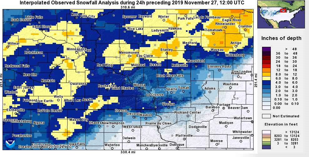 Snow Amounts |
Wind:
Public Information Statement
National Weather Service La Crosse WI
244 PM CST Wed Nov 27 2019

...HIGHEST WIND REPORTS FROM TODAY...

Location                     Speed     Time/Date       Lat/Lon

...Iowa...

...Fayette County...
Oelwein Municipal Airport    45 MPH    1015 AM 11/27   42.68N/91.97W

...Floyd County...
Charles City Airport         44 MPH    1155 AM 11/27   43.07N/92.62W
Nashua - Northeast Isu-Rdf   32 MPH    1100 AM 11/27   42.94N/92.57W

...Howard County...
Saratoga                     36 MPH    0945 AM 11/27   43.35N/92.42W
Riceville                    30 MPH    1215 PM 11/27   43.36N/92.48W

...Winneshiek County...
Decorah Municipal Airport    44 MPH    1155 AM 11/27   43.27N/91.72W
5 NW Frankville              38 MPH    0120 PM 11/27   43.25N/91.70W

...Minnesota...

...Dodge County...
2 E Kasson                   44 MPH    0630 AM 11/27   44.02N/92.71W
Dodge Center Airport         39 MPH    0616 AM 11/27   44.02N/92.82W

...Fillmore County...
2 ESE Canton                 44 MPH    0950 AM 11/27   43.52N/91.89W
Preston Airport              37 MPH    1015 AM 11/27   43.68N/92.17W

...Mower County...
1 ENE Dexter                 42 MPH    0850 AM 11/27   43.73N/92.68W
Austin Municipal Airport     37 MPH    1115 AM 11/27   43.67N/92.92W

...Olmsted County...
Rochester International Airp 51 MPH    0738 AM 11/27   43.90N/92.50W
Mayo Helipad                 43 MPH    0816 AM 11/27   44.02N/92.48W
3 N Stewartville             42 MPH    0840 AM 11/27   43.90N/92.48W
Jct CR 7 I-90 Mile Post 226  40 MPH    1130 AM 11/27   43.96N/92.21W
Byron                        30 MPH    0846 AM 11/27   44.04N/92.64W

...Wabasha County...
1 SSE Kellogg                37 MPH    1020 AM 11/27   44.28N/91.99W
Lake City                    34 MPH    0721 AM 11/27   44.32N/92.44W

...Winona County...
1 E Ridgeway                 34 MPH    0145 PM 11/27   43.91N/91.54W
Winona Municipal Airport     32 MPH    0836 AM 11/27   44.07N/91.70W

...Wisconsin...

...Crawford County...
Prairie Du Chien  Airport    43 MPH    1015 AM 11/27   43.02N/91.12W

...Grant County...
Lancaster                    40 MPH    1041 AM 11/27   42.83N/90.69W
Boscobel Airport             38 MPH    1202 PM 11/27   43.15N/90.68W
Platteville Municipal Airpor 37 MPH    0115 PM 11/27   42.68N/90.43W
Boscobel                     31 MPH    0103 PM 11/27   43.15N/90.68W

...Jackson County...
1 E Black River Falls        33 MPH    0115 PM 11/27   44.30N/90.73W
Black River Falls Area Airpo 31 MPH    1235 PM 11/27   44.25N/90.85W

...Juneau County...
Volk Field                   45 MPH    1126 AM 11/27   43.92N/90.27W
Necedah                      45 MPH    1248 PM 11/27   44.03N/90.08W
Mauston Airport              39 MPH    1215 PM 11/27   43.83N/90.13W

...La Crosse County...
La Crosse Regional Airport   44 MPH    0902 AM 11/27   43.88N/91.25W
La Crosse                    36 MPH    0931 AM 11/27   43.77N/91.22W
St. Joseph 3W                33 MPH    1134 AM 11/27   43.80N/91.10W

...Monroe County...
Sparta/Fort McCoy Airport    41 MPH    0955 AM 11/27   43.97N/90.73W

...Taylor County...
Medford Airport              38 MPH    1235 PM 11/27   45.10N/90.30W
3 NE Lublin                  33 MPH    0914 AM 11/27   45.11N/90.69W
Medford                      33 MPH    1032 AM 11/27   45.30N/90.30W

...Vernon County...
Viroqua Municipal Airport    36 MPH    1235 PM 11/27   43.58N/90.90W

Observations are collected from a variety of sources with varying
equipment and exposures. We thank all volunteer weather observers
for their dedication. Not all data listed are considered official.

$$
Snow/Ice
Public Information Statement
National Weather Service La Crosse WI
1155 AM CST Wed Nov 27 2019

...STORM TOTALS RECEIVED SINCE 9 AM...

Location                     Amount    Time/Date       Lat/Lon

...Iowa...

...Mitchell County...
Carpenter                    7.0 in    0918 AM 11/27   43.41N/93.02W

...Minnesota...

...Dodge County...
Kasson                       7.3 in    0900 AM 11/27   44.03N/92.75W

...Fillmore County...
Peterson                     4.0 in    0900 AM 11/27   43.79N/91.83W

...Houston County...
Spring Grove                 6.3 in    1108 AM 11/27   43.56N/91.64W

...Mower County...
1 SW Austin                  4.5 in    0852 AM 11/27   43.66N/92.98W

...Olmsted County...
2 SSE Rochester              6.3 in    0855 AM 11/27   44.01N/92.42W

...Winona County...
Winona 1.3 SSW               7.0 in    1030 AM 11/27   44.03N/91.68W
Winona                       3.0 in    0900 AM 11/27   44.05N/91.66W

...Wisconsin...

...Adams County...
2 E Strongs Prairie          1.0 in    1127 AM 11/27   44.06N/89.94W

...Buffalo County...
Nelson                       5.0 in    1111 AM 11/27   44.42N/92.00W

...Clark County...
2 SSE Longwood               3.0 in    1115 AM 11/27   44.86N/90.59W

...Jackson County...
Northfield                   7.0 in    1120 AM 11/27   44.46N/91.10W

...Juneau County...
4 ESE Lemonweir              1.0 in    1139 AM 11/27   43.76N/89.95W

...La Crosse County...
3 SSW Barre Mills            6.5 in    0930 AM 11/27   43.80N/91.15W
6 SSE La Crosse              4.5 in    0856 AM 11/27   43.75N/91.18W

...Monroe County...
Tomah                        3.5 in    0922 AM 11/27   43.99N/90.50W
Tomah                        3.0 in    1133 AM 11/27   43.99N/90.50W

...Taylor County...
3 NNW Lublin                 10.0 in   1126 AM 11/27   45.12N/90.75W

...Trempealeau County...
3 W Frenchville              2.3 in    1115 AM 11/27   44.14N/91.38W

Observations are collected from a variety of sources with varying
equipment and exposures. We thank all volunteer weather observers
for their dedication. Not all data listed are considered official.

$$
Photos:
Header
| Caption (source) |
Caption (source) |
Caption (source) |
Caption (source) |
Rain Reports
 |
Media use of NWS Web News Stories is encouraged! Please acknowledge the NWS as the source of any news information accessed from this site. |
|

