During November 2020, average temperatures ranged 3 to 6F warmer-than-normal across the Upper Mississippi River Valley. These temperatures were more typical of October than November. Average temperatures ranged from 47.1F at Medford Taylor County Airport (Taylor County, WI) to 54.7F at Decorah, IA. It was the 8th warmest November in La Crosse ( 5 out of the 8 warmest Novembers have occurred since 2001) and 12th warmest in Rochester.
Precipitation generally ranged from 1 to 3 inches across the region. This was within 1 inch of normal for most locations. Precipitation total ranged from 0.87” at Prairie du Chien, WI to 3.05” at Osage, IA.
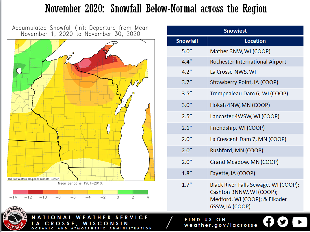
Snowfall was anywhere from 2 to 6 inches below normal across the Upper Mississippi River Valley. The highest snow total was 5 inches near Mather, WI.
Here are the November 2020 climate summaries for La Crosse, WI and Rochester, MN.
 |
 |
 |
| November 2020 Temperature Departures |
November 2020 Precipitation Departures |
November 2020 Snowfall Departures |
...November was Warmer Than Normal and Slightly Above Normal
precipitation in La Crosse Wisconsin...

...November Highlights...

The average temperature was 41.8 degrees. This was 5.9 degrees warmer
than normal. The highest temperature of 75 degrees occurred on the 6th
and 9th. The lowest temperature of 30 degrees occurred on the
30th. There were 22 days where the average daily temperature was
at or above normal. The warmest stretch occurred from the 3rd
through the 9th where the daily average temperature ranged from 12
to 26 degrees above normal. There were no days during the
month...where the high temperature was at or below 32 degrees.
Typically...November averages 5 days where the high temperatures
is at or below 32 degrees.

A total of 2.40 inches of precipitation fell. This was 0.39
inches above normal. The majority of the precipitation occurred on
the 9th and 10th where 1.67 inches of precipitation fell with only 6
days of measurable precipitation in the month.

La Crosse, Wisconsin received 1.0 inch of snow in the month. This
one inch of snow fell on 1 day the 24th. Typically...November
averages 3 days of measurable snowfall in November.

...Records...

The temperature climbed to 73 degrees on November 5th. This broke
the daily record high of 72 degrees previously set in 2016.

The temperature climbed to 75 degrees on November 6th. This broke
the daily record high of 71 degrees previously set in 2016.

The temperature dropped to 60 degrees occurred on November 7th.
This broke the daily record warmest low temperature of 59 degrees
previously set in 1874.

The temperature dropped to 57 degrees occurred on November 8th.
This broke the daily record warmest low temperature 53 degrees
previously set in 1874.

The temperature climb to 75 degree on November 9th. This tied the
record daily high temperature which was last set in 1999.

...November was Warmer Than Normal and Received Above Normal
precipitation in Rochester Minnesota...

...November Highlights...

The average temperature was 37.9 degrees. This was 4.0 degrees
warmer than normal. The highest temperature of 74 degrees
occurred on the 3rd. The lowest temperature of 13 degrees
occurred on the 13th. There were 19 days where the average daily
temperature was at or above normal. The warmest stretch occurred
from the 3rd through the 9th where the daily average temperature
ranged from 12 to 24 degrees above normal. There were no days
during the month...where the high temperature was at or below 32
degrees. Typically...November averages 6 days where the high
temperatures is at or below 32 degrees.

A total of 2.52 inches of precipitation fell. This was 0.61
inches above normal. The majority of the precipitation occurred on
the 9th and 10th where 1.89 inches of precipitation fell with only 5
days of measurable precipitation in the month.

Rochester, Minnesota received 4.4 inches of snow in the month with 5
days of measurable snow. Typically...November averages 3 days of
snowfall.

...Records...

The temperature dropped to 54 degrees on November 7th breaking the
previous record daily warmest low temperature of 50 degrees set in
1977.

A daily record snowfall occurred on November 24th where 4.0 inches
of snow fell. This broke the previous record of 2.2 inches set in
1977.


 Weather Story
 Weather Map
 Local Radar