Upper Mississippi River Climate Summary for Meteorological Spring 2024:
|
|
|
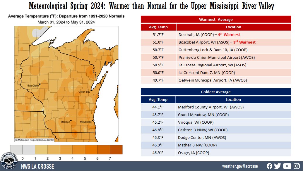 |
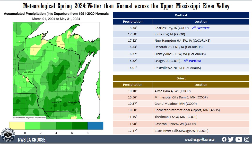
Precipitation - Wetter than Normal
|
 |
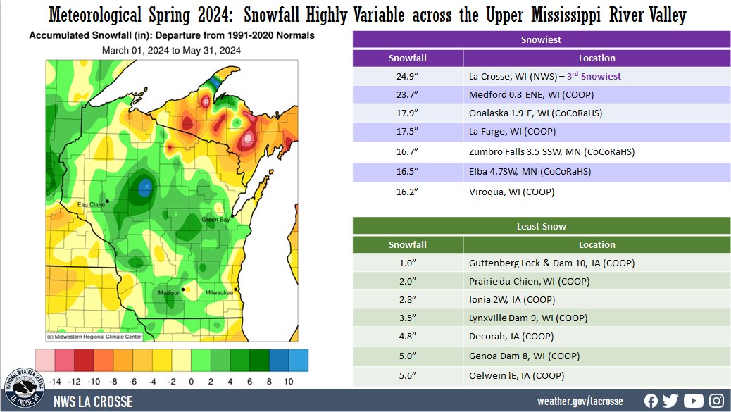
Snowfall - Highly Variable
|
 |
Below are the climate summaries for the 2024 meteorological spring in La Crosse, WI and Rochester, MN
The 2024 meteorological spring (March 1 through May 31) was tied for the 13th warmest with 1910 and the 12th wettest for La Crosse, WI. More details on these statistics can be found below.
|
Temperatures - Tied for 12th Warmest with 1910 & 1985
|
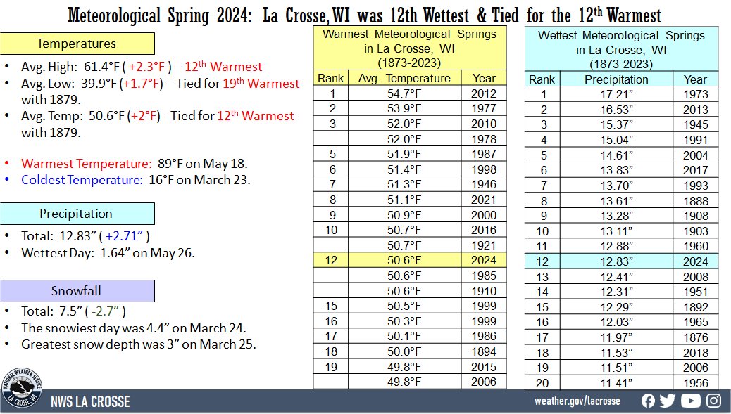 |
Warmest Meteorological Springs
in La Crosse, WI
1873-2024
Average
Rank Temperature Year
---- ----------- ----
1 54.7°F 2012
2 53.9°F 1977
3 52.0°F 2010
52.0°F 1878
5 51.9°F 1987
6 51.4°F 1998
7 51.3°F 1946
8 51.1°F 2021
9 50.9°F 2000
10 50.7°F 2016
50.7°F 1921
12 50.6°F 2024
50.6°F 1985
50.6°F 1910
15 50.5°F 1999
16 50.3°F 2007
17 50.1°F 1986
18 50.0°F 1894
19 49.8°F 2015
49.8°F 2006
The table below contains the monthly temperatures and their departures from normal for the spring of 2024.
Spring 2024 Temperatures
in La Crosse WI
Average Departure
Month Temperature from Normal
----- ----------- -----------
March 39.9°F +4.1°F - Tied for 14th Warmest
with 1977
April 49.5°F +0.5°F
May 62.5°F +1.5°F
Spring 50.6°F +2.0°F - Tied with 1910 and 1985
for 12th Warmest
Precipitation - 12th Wettest
Wettest Meteorological Springs
for La Crosse, WI
1873-2020
Rainfall
Rank Amount Year
---- -------- ----
1 17.21 inches 1973
2 16.53 inches 2013
3 15.37 inches 1945
4 15.04 inches 1991
5 14.61 inches 2004
6 13.83 inches 2017
7 13.70 inches 1993
8 13.61 inches 1888
9 13.28 inches 1908
10 13.11 inches 1903
11 12.88 inches 1960
12 12.83 inches 2024
13 12.41 inches 2008
14 12.31 inches 1951
15 12.29 inches 1892
16 12.03 inches 1965
17 11.97 inches 1876
18 11.53 inches 2018
19 11.51 inches 2006
20 11.41 inches 1956
Spring 2024 Precipitation
in La Crosse WI
Precipitation Departure
Month Total from Normal
----- ------------- -----------
March 1.86 inches -0.18 inches
April 4.26 inches +0.51 inches
May 6.71 inches +2.38 inches - 12th Wettest
Spring 12.83 inches +2.71 inches - 12th Wettest
Snowfall - Below Normal
Spring 2024 Snowfall
in La Crosse WI
Snowfall Departure
Month Total from Normal
----- ------------- -----------
March 6.4 inches -0.9 inches
April 1.1 inches -1.8 inches
May 0.0 inches 0.0 inches
Spring 7.7 inches -2.7 inches
The 2024 meteorological spring (March 1 through May 31) was tied with 2000 for the 8th warmest and 22nd wettest for Rochester, MN. More details on these statistics can be found below.
|
Temperatures - Tied with 2000 for the 8th Warmest Spring
|
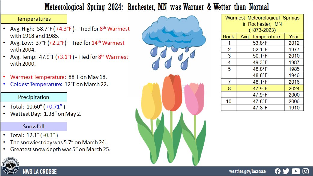 |
Warmest Meteorological Springs
in Rochester, MN
1886-2024
Average
Rank Temperature Year
---- ----------- ----
1 53.8°F 2012
2 52.1°F 1977
3 50.1°F 2010
4 49.3°F 1987
5 48.8°F 1985
48.8°F 1946
7 48.1°F 2016
8 47.9°F 2024
47.9°F 2000
10 47.8°F 2006
47.8°F 1910
Spring 2024 Temperatures
in Rochester MN
Average Departure
Month Temperature from Normal
----- ----------- -----------
March 37.3°F +5.6°F - 11th Warmest
April 46.8°F +1.6°F
May 59.4°F +1.8°F
Spring 47.9°F +3.1°F - Tied for 8th Warmest
with 2000
Precipitation - 22nd Wettest Spring
Spring 2024 Precipitation
in Rochester MN
Precipitation Departure
Month Total from Normal
----- ------------- -----------
March 2.35 inches +0.33 inches
April 3.92 inches +0.40 inches
May 4.33 inches -0.02 inches
Spring 10.60 inches +0.71 inches
Snowfall - Slightly Below Normal
Spring 2024 Snowfall
in Rochester MN
Snowfall Departure
Month Total from Normal
----- ------------- -----------
March 8.6 inches 0.0 inches
April 3.5 inches +0.2 inches
May 0.0 inches -0.5 inches
Spring 12.1 inches -0.3 inches


 Weather Story
 Weather Map
 Local Radar