| During the meteorological spring of 2022 (March 1 through May 31), temperature anomalies ranged from 2°F below normal to near normal across the Upper Mississippi River Valley. Average temperatures ranged from 39.5°F at Medford, WI (COOP) to 47.7°F at Boscobel, WI (ASOS). The coldest temperature was -8°F at Medford (COOP) on March 12 and the hottest temperature was 97°F at Boscobel Airport, WI (ASOS) on May 12. This is a 105°F difference. | 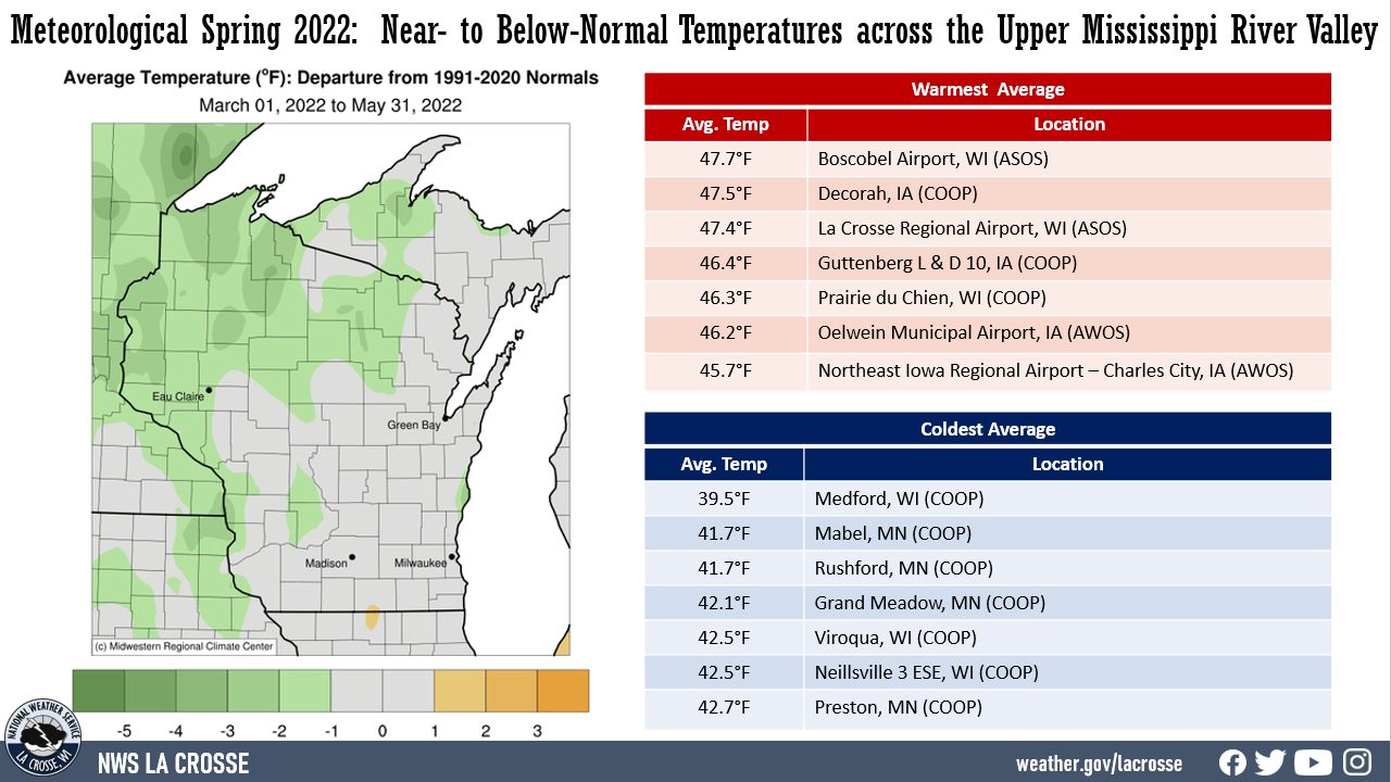 |
| Precipitation anomalies ranged from 3" drier-than-normal to 4" wetter-than-normal across the Upper Mississippi River Valley. Precipitation totals ranged from 6.65” near Oelwein, IA (COOP) to 14.18” near Rochester, MN (CoCoRaHS). The wettest 1-day precipitation was 4.50" at St. Ansgar, IA (COOP). This precipitation fell from 7 AM on April 12 to 7 AM on April 13. | 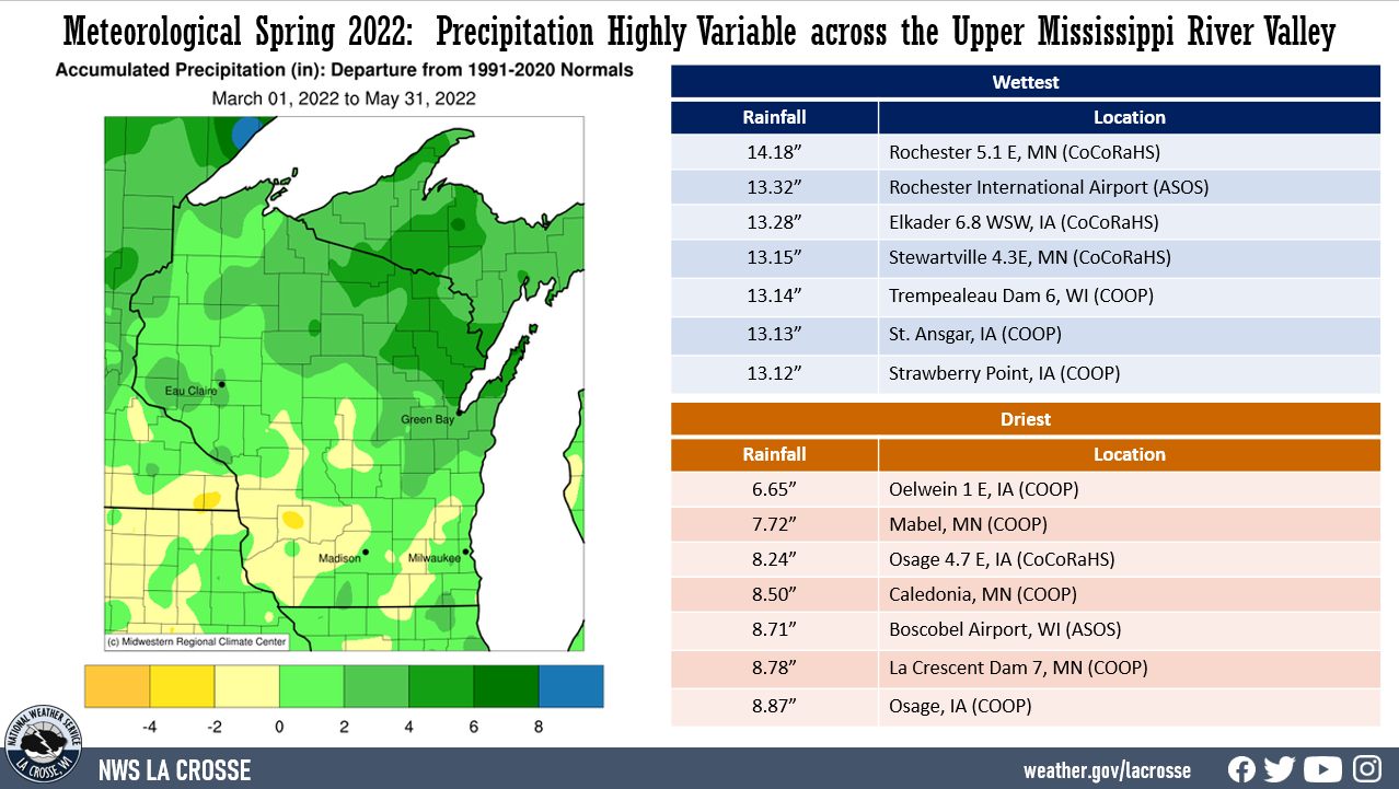 |
| Snowfall anomalies ranged from 15" below-normal to 5" above-normal. Snowfall totals ranged from 0" at Minnesota City Dam 5, Rushford, and Winona Dam 5 in southeast Minnesota to 12.8" at Medford, WI. The snowiest day was 6.6" near Prairie du Chien, WI (CoCoRaHS) from 7 AM on March 6 to 7 AM on March 7. | 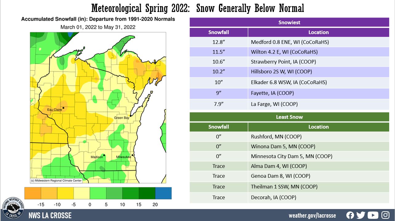 |
Below are the climate summaries for the 2022 meteorological spring in La Crosse, WI and Rochester, MN
|
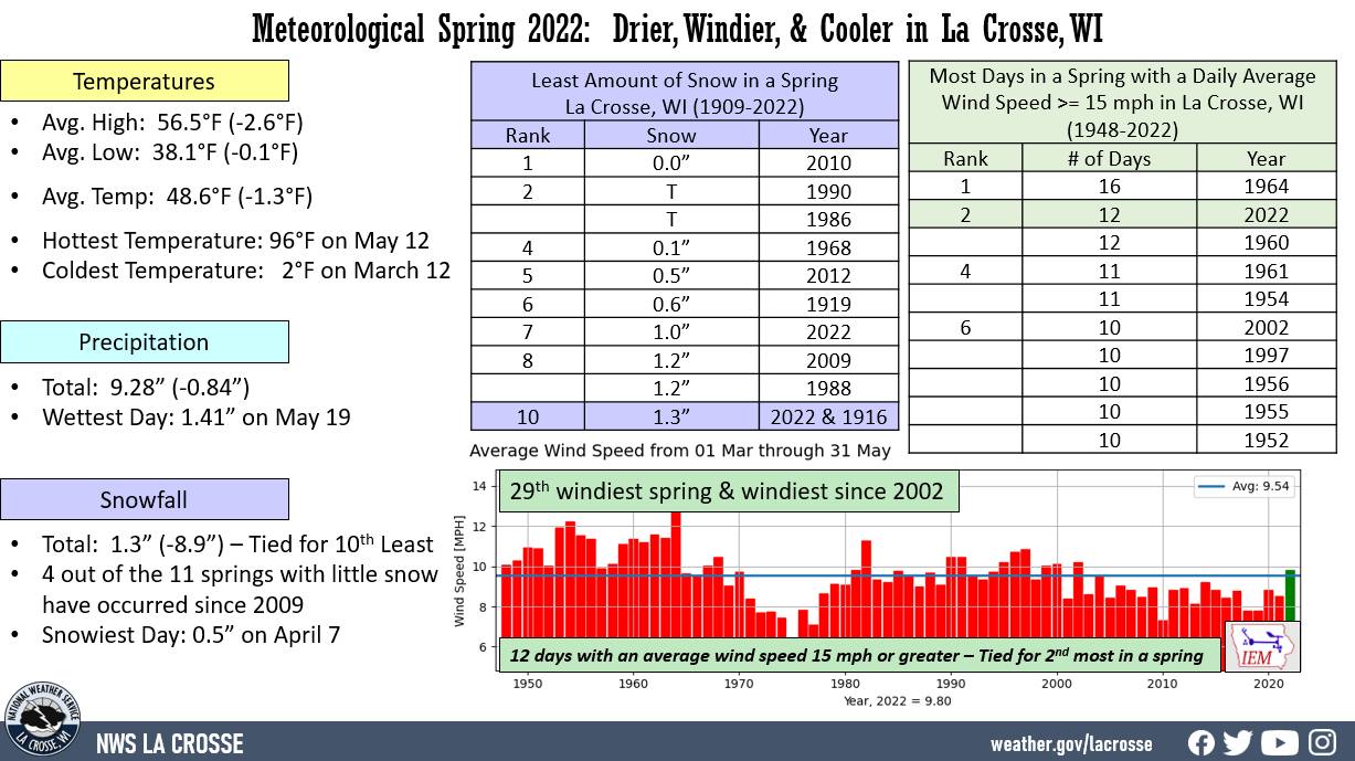
The meteorological spring of 2021 was slightly cooler (1.3°F cooler-than-normal) and drier-than-normal (0.84" drier-than-normal) at La Crosse Regional Airport. More details on these statistics can be found below. Temperatures - Cooler than Normal From March 1st through May 31st, La Crosse Regional Airport had an average temperature of 47.3°F. This was 1.3°F cooler than the 1991-2020 normal of 48.6°F. This was the coolest spring since 2019 (45.4°F). The table below contains the monthly temperatures and their departures from normal for the spring of 2022. |
 |
Spring 2022 Temperatures
in La Crosse WI
Average Departure
Month Temperature from Normal
----- ----------- -----------
March 35.2°F -0.6°F
April 44.5°F -4.5°F
May 62.4°F +1.4°F
Spring 47.3°F -1.7°F
Precipitation - Slightly Drier than Normal
From March 1st through May 31st, La Crosse Regional Airport received 9.28" of precipitation. This was 0.84" drier than the 1991-2020 spring normal of 10.12". The table below contains the monthly precipitation totals and their departures from normal for the spring of 2022.
Spring 2022 Precipitation
in La Crosse WI
Precipitation Departure
Month Total from Normal
----- ------------- -----------
March 1.81 inches -0.23 inches
April 3.27 inches -0.48 inches
May 4.20 inches -0.13 inches
Spring 9.28 inches -0.84 inches
Snowfall - Tied for 10th Least
From March 1st through May 31st, the snow observer near La Crosse Regional Airport recorded 1.3". This was 8.9" less than the 1991-2020 normal of 10.2". This was tied for 10th least with 1916. 4 out of the 11 springs with little snow have occurred since 2009. The table below contains the monthly snowfall totals and their departures from normal for the spring of 2022.
Spring 2022 Snowfall
in La Crosse WI
Snowfall Departure
Month Total from Normal
----- ------------- -----------
March 0.3 inches -7.0 inches
Tied for 8th least in a March with 1990
April 1.0 inch -1.9 inches
May 0.0 inches 0.0 inches
Spring 1.3 inches -8.9 inches
Tied for 10th Least with 1916
Winds - Windiest Spring since 2002
|
The meteorological spring of 2022 was cooler (0.9°F cooler-than-normal), windier, and wetter-than-normal (3.43" wetter-than-normal) at Rochester International Airport. This was the 7th wettest spring and 7th least snow for a spring. There were 16 days when the daily average wind speed was 20 mph or greater. This was the 6th most in a spring. More details on these statistics can be found below. Temperatures - Coolest Spring since 2019 From March 1st through May 31st, Rochester International Airport had an average temperature of 43.9°F. This was 0.9°F cooler than the 1991-2020 normal of 44.8°F. This was the coolest spring since 2019 (45.1°F). |
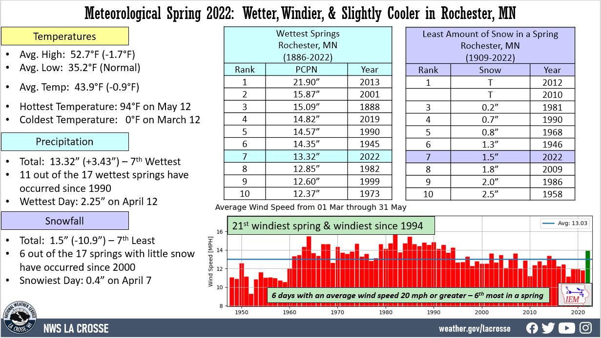 |
The table below contains the monthly temperatures and their departures from normal for the spring of 2022.
Spring 2022 Temperatures
in Rochester MN
Average Departure
Month Temperature from Normal
----- ----------- -----------
March 32.3°F +0.6°F
April 40.3°F -4.9°F
Tied for 12th Coldest April
May 59.3°F +1.7°F
Spring 43.9°F -0.9°F
Precipitation - 7th Wettest and Wettest since 2019
From March 1st through May 31st, Rochester International Airport received 13.32" of precipitation. This was 3.43" wetter than the 1991-2020 normal of 9.89". This was the 7th wettest spring. 11 out of the 17 wettest springs have occurred since 1990. This was the wettest spring since 2019 (14.82" - 5th wettest). The wettest spring occurred in 2013 when 21.90" of precipitation fell. The table below contains the monthly precipitation totals and their departures from normal for the spring of 2022.
Spring 2022 Precipitation
in Rochester MN
Precipitation Departure
Month Total from Normal
----- ------------- -----------
March 2.29 inches +0.27 inches
April 6.83 inches +3.52 inches
2nd Wettest April
May 4.20 inches -0.15 inches
Spring 13.32 inches +3.43 inches
7th Wettest Spring
Snowfall - 7th Least and the Least since 2012
From March 1st through May 31st, the snow observer near Rochester International Airport recorded 1.5" of snow. This was 10.9" less than the 1991-2020 normal of 12.4". 6 out of the 17 springs with little snow have occurred since 2000. The table below contains the monthly snowfall totals and their departures from normal for the spring of 2022.
Spring 2022 Snowfall
in Rochester MN
Snowfall Departure
Month Total from Normal
----- ------------- -----------
March 0.6 inches -8.0 inches
7th least for March
April 0.9 inches -2.4 inches
8th least for April
May 0.0 inches -0.5 inches
Spring 8.9 inches -10.9 inches
7th least for a spring
Winds - Windiest Spring since 1994


 Weather Story
 Weather Map
 Local Radar