Temperature
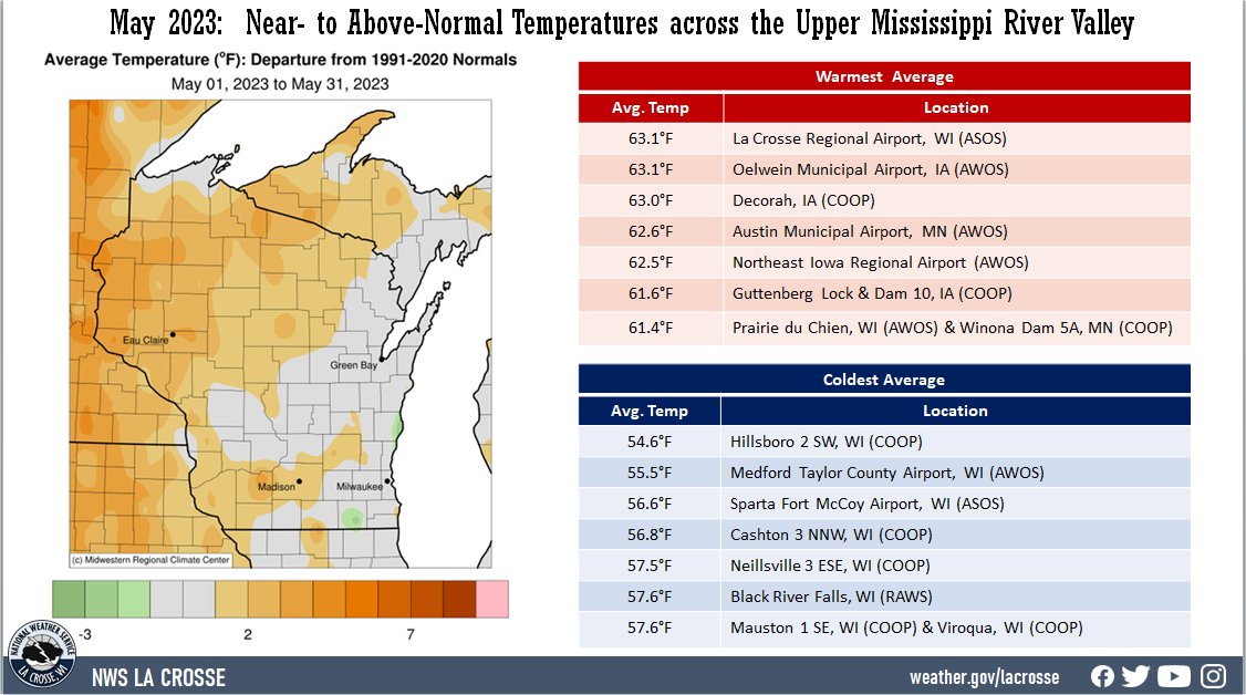
| During May 2023, average temperatures ranged from 54.6°F 2 miles southwest of Hillsboro, WI (COOP observer) to 63.1°F at La Crosse Regional Airport (AWOS) and Oelwein Municipal Airport (AWOS) in the Upper Mississippi River Valley. Temperature anomalies ranged from near normal to 4°F warmer than normal. Rochester, MN tied 1991 (60.9°F) for their 16th warmest May. La Crosse, WI tied 1959 (63.1°F) for their 24th warmest May. The warmest temperature was 92°F at the Boscobel Airport (ASOS) on May 31. Meanwhile, the coldest temperature was 24°F in Mabel, MN (COOP) on May 4. |
 |
Precipitation
|
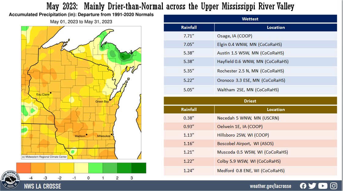
Precipitation ranged from 0.38" near Necedah, WI (USCRN) to 7.71" at Osage, IA (COOP). This precipitation ranged from 3" below normal to 1" wetter than normal. La Crosse Regional Airport (1.75") tied 1924 and 1953 for its 19th driest May. The highest one-day precipitation was 4.83" at Osage, IA (COOP) from May 11-12.
The unusually dry May for much of the area resulted in the expansion of the abnormally dry (D0) conditions across the La Crosse County Hydrologic Service Area (HSA). At the beginning of May, only 8.6% of the HSA was in D0. By the end of May, this had expanded to just over half (51.87%) of the HSA. In addition, a small area (2.47%) of moderate (D1) drought developed in parts of Chickasaw and Fayette counties in northeast Iowa.
May 2023 was a quiet severe weather month for the NWS La Crosse County Warning Area. There were only 3 convective warnings (1 Severe Thunderstorm Warning and 2 Flash Flood Warnings) issued. This was tied with 1988, 1991, 1993, and 2020 for the 6th least in May. The greatest was 83 warnings in 2013. There was only 1 Severe Thunderstorm Warning issued. This tied 2005, 2009, and 2020 for the 3rd least in May. Only 1986 and 1990 saw less (no Severe Thunderstorm Warnings). The greatest number of Severe Thunderstorm Warnings in May was 64 in 1998. There were 2 Flash Flood Warnings issued. This was tied for the 7th most with 2010 and 2022. The most Flash Flood Warnings in May was 18 in 2004. Severe weather records date back to 1986.
|
 |
Below are the May 2023 climate summaries for La Crosse, WI, and Rochester, MN...
La Crosse, WI
May 2023 was Warm and Dry in La Crosse, WI
May 2023 Highlights
|
Temperatures - Tied for 24th Warmest May
- The average temperature at La Crosse Regional Airport was 63.1°F. This was 2.1°F warmer than the 1991-2020 normal of 61°F. This was tied for the 24th warmest May with 1959 and the warmest May since 2018 (67.6°F - 2nd warmest).
- The average high temperature was 75.4°F. This was 3.4°F warmer than the 1991-2020 normal of 72°F. This was the 15th warmest during May and the warmest since 2018 (78.8°F - 5th warmest).
- The average low temperature was 50.8°F. This was 0.7°F warmer than the 1991-2020 normal of 50.1°F.
|
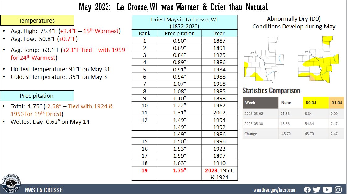 |
- The warmest temperature was 91°F on May 31.
- The coldest temperature was 35°F on May 3.
- There were 2 days in which the temperature reached or exceeded 90°F. Normally, there is 1 day.
Precipitation...Tied for the 19th Driest May
- A total of 1.75" of precipitation fell. This was 2.58" drier than the 1991-2020 normal of 4.33".
- This was tied for the 19th driest May with 1924 and 1953. It was the driest May since 2002 (1.31 inches - 11th driest May).
- The wettest day was 0.62" on May 14.
May 2023 Records...
Looking ahead to June...
- The normal high temperature in La Crosse rises from 78°F on June 1st to 85°F on the 30th. The normal low temperature rises from 56°F on the 1st to 64°F by the end of the month. The normal mean temperature for the month is 71.0°F. La Crosse’s hottest June occurred back in 1993 with an average temperature of 76.5°F, and their coldest June occurred in 1969 with an average temperature of 61.4°F.
- For June, the hottest temperature ever recorded was 102°F on June 20, 1933, and June 21, 1988, and the coldest temperature was 33°F on June 1, 1897. There are typically 4 days with temperatures at or above 90°F.
- The average precipitation for June is 5.08". The wettest June occurred in 1899 when 11.56" of precipitation fell. The driest June occurred in 1910 when 0.37" of precipitation fell. The wettest June day was 4.50" on June 18, 2011. Normally, there are 7 days with thunderstorms.
Rochester, MN
Rochester
May 2023 was Unusually Warm and Slightly Wetter in Rochester, MN
May 2023 Highlights...
|
Temperatures...Tied for the 16th Warmest
- The average temperature at Rochester International Airport was 60.9°F. This was 3.3°F warmer than the 1991-2020 normal of 57.6°F. This was tied for the 16th warmest May with 1991 and the warmest May since 2018 (64.1°F - 3rd warmest).
- The average high temperature was 72.6°F. This was 4.6°F warmer than the 1991-2020 normal of 68°F. This was tied with 1972 for the 18th warmest May and the warmest since 2018 (74.8°F - 8th warmest).
- The average low temperature was 49.1°F. This was 2°F warmer than the 1991-2020 normal of 47.1°F. This was the 18th warmest May and the warmest since 2018 (53.5°F - warmest).
|
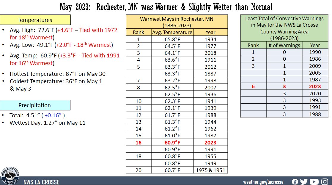 |
- The warmest temperature was 87°F on May 30.
- The coldest temperature was 36°F on May 1.
- There were 0 days in which the temperature reached or exceeded 90°F. Normally, there is 1 day.
Precipitation...Slightly Wetter-than-Normal
- A total of 4.51" of precipitation fell. This was 0.16" wetter than the 1991-2020 normal of 4.35".
- The wettest day was 1.27" on May 11.
May 2023 Records...
Looking ahead to June...
- The normal high temperature in Rochester rises from 74°F on June 1st to 80°F by the end of the month. The normal low temperature rises from 53°F on the 1st to 61°F by the end of the month. The normal mean temperature for the month is 67.5°F. Rochester’s hottest June occurred back in 1933 with an average temperature of 73.9°F, and their coldest June occurred in 1969 with an average temperature of 59.6°F.
- For June, the hottest temperature ever recorded was 105°F on June 27, 1934, and the coldest temperature was 31°F on June 9, 1937. There are typically 2 days with temperatures at or above 90°F.
- The average precipitation for June is 5.35". The wettest June occurred in 2000 when 12.51" of precipitation fell. The driest June occurred in 1910 when a trace of precipitation fell. The wettest June day was 4.90" on June 28, 2019. Normally, there are 8 days with thunderstorms.

